Hurricane Wilma - Cat. 5
Moderator: S2k Moderators
-
Toro694
-
WindRunner

- Category 5

- Posts: 5803
- Age: 35
- Joined: Fri Jul 29, 2005 8:07 pm
- Location: Warrenton, VA, but Albany, NY for school
- Contact:
00Z model runs:
150
WHXX01 KWBC 210036
CHGHUR
DISCLAIMER...NUMERICAL MODELS ARE SUBJECT TO LARGE ERRORS.
PLEASE REFER TO TPC/NHC OFFICIAL FORECASTS FOR TROPICAL CYCLONES.
NATIONAL HURRICANE CENTER NORTH ATLANTIC OBJECTIVE AIDS FOR
HURRICANE WILMA (AL242005) ON 20051021 0000 UTC
...00 HRS... ...12 HRS... ...24 HRS... ...36 HRS...
051021 0000 051021 1200 051022 0000 051022 1200
LAT LON LAT LON LAT LON LAT LON
BAMD 19.1N 85.8W 20.1N 86.9W 20.8N 87.9W 21.0N 88.7W
BAMM 19.1N 85.8W 19.9N 87.2W 20.4N 88.0W 20.4N 88.5W
A98E 19.1N 85.8W 19.9N 86.5W 20.5N 87.4W 21.2N 87.7W
LBAR 19.1N 85.8W 20.4N 86.7W 21.8N 87.2W 23.5N 86.8W
SHIP 130KTS 132KTS 135KTS 135KTS
DSHP 130KTS 132KTS 135KTS 135KTS
...48 HRS... ...72 HRS... ...96 HRS... ..120 HRS...
051023 0000 051024 0000 051025 0000 051026 0000
LAT LON LAT LON LAT LON LAT LON
BAMD 21.2N 89.6W 21.2N 90.8W 20.1N 88.3W 23.3N 81.0W
BAMM 20.2N 89.1W 20.2N 89.5W 21.4N 84.0W 29.0N 76.0W
A98E 21.5N 88.0W 24.3N 86.2W 29.1N 80.8W 39.8N 76.5W
LBAR 25.9N 84.9W 33.6N 74.3W .0N .0W .0N .0W
SHIP 129KTS 108KTS 74KTS 33KTS
DSHP 129KTS 108KTS 64KTS 22KTS
...INITIAL CONDITIONS...
LATCUR = 19.1N LONCUR = 85.8W DIRCUR = 320DEG SPDCUR = 5KT
LATM12 = 18.3N LONM12 = 85.2W DIRM12 = 303DEG SPDM12 = 5KT
LATM24 = 18.0N LONM24 = 84.0W
WNDCUR = 130KT RMAXWD = 20NM WNDM12 = 125KT
CENPRS = 923MB OUTPRS = 1009MB OUTRAD = 250NM SDEPTH = D
RD34NE = 175NM RD34SE = 150NM RD34SW = 120NM RD34NW = 175NM
0 likes

inotherwords wrote:I would not put too much credence on the Schnitt show, especially vs. the NHC. "Schnitt" is the same guy as the morning DJ called MJ on 93.3 FLZ in Tampa. He's just a blowhard.
If I want meteorological advice, I'll take it from the NHC and not from some right-wing talk monkey.
Hey inotherwords.....I hope you have a job in something other than weather forecasting,or politics.Seems you have limited knowledge in neither.Typical lefty
0 likes
-
truballer#1

-
Foladar0
CDO62 wrote:inotherwords wrote:I would not put too much credence on the Schnitt show, especially vs. the NHC. "Schnitt" is the same guy as the morning DJ called MJ on 93.3 FLZ in Tampa. He's just a blowhard.
If I want meteorological advice, I'll take it from the NHC and not from some right-wing talk monkey.
Hey inotherwords.....I hope you have a job in something other than weather forecasting,or politics.Seems you have limited knowledge in neither.Typical lefty
Politics = no no.
0 likes


CDO62 wrote:inotherwords wrote:I would not put too much credence on the Schnitt show, especially vs. the NHC. "Schnitt" is the same guy as the morning DJ called MJ on 93.3 FLZ in Tampa. He's just a blowhard.
If I want meteorological advice, I'll take it from the NHC and not from some right-wing talk monkey.
Hey inotherwords.....I hope you have a job in something other than weather forecasting,or politics.Seems you have limited knowledge in neither.Typical lefty
Ugh... what the hell does that have to do with just about anything?
0 likes
-
cycloneye

- Admin

- Posts: 149328
- Age: 69
- Joined: Thu Oct 10, 2002 10:54 am
- Location: San Juan, Puerto Rico
So far so good the discussions in this thread from the first page with very different opinions posted but with respect to others who may not have the same view.Let's continue these discussions about the models,the track,the movement,the wobbles,the intensity,posting sat pics,until Wilma decides what will she do finnally and she is gone at the end in the NE coast.In other words this thread will be open until the final advisorie is written so the 110 pages for Katrina will be a memory as this thread will surpass that one by many pages so folks continue to post away.
0 likes
Visit the Caribbean-Central America Weather Thread where you can find at first post web cams,radars
and observations from Caribbean basin members Click Here
and observations from Caribbean basin members Click Here
-
truballer#1

My current opinion:
GFDL goes out to lunch at 12z
Today's 18z GFS and GFDL are getting on my nerves!
http://moe.met.fsu.edu/cyclonephase/gfs ... 018/1.html
http://moe.met.fsu.edu/cyclonephase/gfd ... 018/2.html
Now there's a northward into the FL peninsula trend
GFDL goes out to lunch at 12z
Today's 18z GFS and GFDL are getting on my nerves!
http://moe.met.fsu.edu/cyclonephase/gfs ... 018/1.html
http://moe.met.fsu.edu/cyclonephase/gfd ... 018/2.html
Now there's a northward into the FL peninsula trend
0 likes


CDO62 wrote:inotherwords wrote:I would not put too much credence on the Schnitt show, especially vs. the NHC. "Schnitt" is the same guy as the morning DJ called MJ on 93.3 FLZ in Tampa. He's just a blowhard.
If I want meteorological advice, I'll take it from the NHC and not from some right-wing talk monkey.
Hey inotherwords.....I hope you have a job in something other than weather forecasting,or politics.Seems you have limited knowledge in neither.Typical lefty
Now that was damn funny! But not allowed. Knock it off.
0 likes
CDO62 wrote:inotherwords wrote:I would not put too much credence on the Schnitt show, especially vs. the NHC. "Schnitt" is the same guy as the morning DJ called MJ on 93.3 FLZ in Tampa. He's just a blowhard.
If I want meteorological advice, I'll take it from the NHC and not from some right-wing talk monkey.
Hey inotherwords.....I hope you have a job in something other than weather forecasting,or politics.Seems you have limited knowledge in neither.Typical lefty
Take this crap elsewhere. Seriously.
0 likes
-
whereverwx
- Category 5
- Posts: 1107
- Joined: Mon May 31, 2004 10:15 pm


-
timeflow

- Tropical Depression

- Posts: 99
- Age: 53
- Joined: Tue Jul 05, 2005 5:48 pm
- Location: Orlando, FL
- Contact:
truballer#1 wrote:purple just exploded all around the storm!
Yeah, that was interesting. It seemed like such a uniform shift into lighter shades of purple, made me think that perhaps this was simply the result of the sun setting. Now that's something I just don't know. (Last year it looked like Jeanne did the same thing leading up to FL landfall.) The eye also appears better as the loop progresses. This storm does seem to be intensifying again. The scary part is that the hurricane force winds are so much broader now, and the eyewall will affect a much larger area with this larger eye... as a Cat 4 or 5...
0 likes
-
markymark8
- Tropical Storm

- Posts: 111
- Joined: Sat Oct 08, 2005 11:57 am
- Location: North Carolina
Wilmas pressure is up to 923 and her eye has looked ragged on infrared satellite most of today and this evening. Like Rita she has never really gotten back that awesome eye back since her ERC. Her eye on the latest infrared has improved alot though. You can still see its not a perfect semectrical eye that a cat 5 should have. The south to southwest part of eyewall looks like it is having a little trouble but the rest of the areas in her eye have gotten alot better in the last half hour. We will see if this trend continues on getting that core better organized and tighten up some more. The 11 pm advisory hopefully will give us some good info on what shes doing and see if her pressure is starting to drop once again. http://www.ssd.noaa.gov/PS/TROP/DATA/RT ... IR4/20.jpg
0 likes

- Belize - -
| discussions | reports | pleas for help | QHWRN | guide | climatology | archive |
--------------------------------------------------------------------------------
- wind,waves and now rain
From: "sailsportsbelize" <info at sailsportsbelize.com>
Date: Thu, 20 Oct 2005 16:01:54 -0600
Just been into town and some parts of the road is flooded from the high surge. A couple of the hotels have lost piers to the waves and there has been a lot of beach erosion, the most I have seen in the last 7 years only Mitch did more damage to the beach side of the island.
the rain has just started with a vengeance. So there will be some more flooding here on the island and more than likely on the mainland.
4.04pm local
Chris
SailSports Belize - Windsurfing, Sailing and Kitesurfing School. Offering vacation packages and certified instruction. http://www.sailsportsbelize.com
Surf Guru - Quiksilver, Ripcurl, Neil Pryde, Reef, Dakine clothing and accessories in Belize
--------------------------------------------------------------------------------
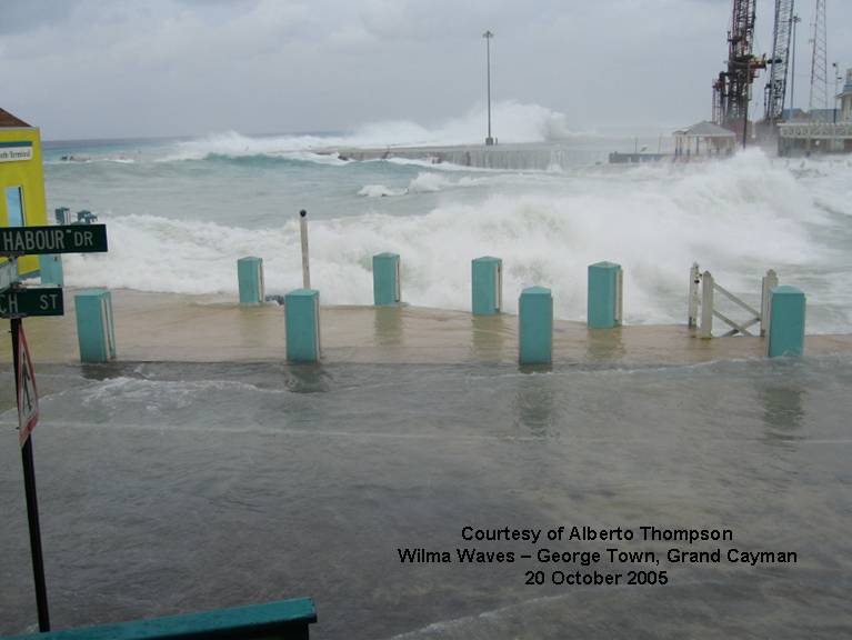
from stormcarib.com
lots of pics of the surge coming in from Cayman Islands here -
(will only post one here)
http://www.stormcarib.com/reports/2005/cayman.shtml
- - Mexico - -
(incl. Cozumel and Cancun)
| discussions | reports | pleas for help | QHWRN | guide | climatology | archive |
--------------------------------------------------------------------------------
- Wilmaaaaaaaaaa
From: "mike, and chrissy hopson" <hotinplaya at playful.com>
Date: Thu, 20 Oct 2005 18:19:26 -0500
Hi every one
We are pretty much ready, this storm is alot differant than Emily, she was small and compact, Wilma is huge and moving so slow,.
We have been in tropical storm winds for several hours, and the storm center will not be here until noon on friday.
I went to the resort Chrissy and I work at 8:00am , for the guest meeting, I was broken hearted, close to tears, we just reopend from Emily Sept 17, and 1 1/2 days before Wilma gets here, we have sufferred extensive damage from the Surf.
All of our guest have been evacuated to one of the mega resorts near Tulumn, where the rooms are far from the beach, much better than last time when they were sent to the Cancun convention center. Believe it or not , we have had checkins at our resort today??? "are you stupid, or just dumb"
On a lighter note, as I was returning home, noticed fire and police cars at a near by condo, when I stopped to see what was happening, turns out the poor fellow had boarded up his 3rd story condo, and then realized he didn't have a way down from his balcony, hince the fire truck!!
the picture is of our staff, these folks have been back to work just one month, but they are all in good spirits , wishing you were here, (and they were'nt)
0 likes
-
O Town
- S2K Supporter

- Posts: 5205
- Age: 52
- Joined: Wed Sep 07, 2005 9:37 pm
- Location: Orlando, Florida 28°35'35"N 81°22'55"W
Thanks for the link, good pics of the wave action. Looks like in the last hour since I watched survivor,she has cleared out the eye completley and ready to intensify agian, and starting to get the complete ring of heavy convection around the eye again. Looks beautiful on imagery but scary for all those in her path. I swar she has something funny going on with that eye. On the IR image it ALMOST looks like a pinwheel type eye starting to form, I know it is just me but she has had an odd eye since the beginning.
0 likes
Radar presentation of the eye wall looks better as well.
http://www.southwx.net/radar/cancun_radar_animated.html
http://www.southwx.net/radar/cancun_radar_animated.html
0 likes

Wilma's eye is contracting on radar - she is getting stronger again - another wobble toward the N-NW too.
http://www.southwx.net/radar/cancun_radar_animated.html
http://www.southwx.net/radar/cancun_radar_animated.html
0 likes
Who is online
Users browsing this forum: No registered users and 10 guests