Hurricane Wilma - Cat. 5

Moderator: S2k Moderators

Message
Author
THead
S2K Supporter
S2K Supporter
Posts: 790
Joined: Mon Aug 30, 2004 5:09 pm
Location: Lauderhill, Fla./Jefferson, Ga.

#2721 Postby THead » Fri Oct 21, 2005 1:01 pm

Derek Ortt wrote:based upon the aircraft data, it appears as if Wilma reached land as a category 3 hurricane, with winds of 125 m.p.h. Not as bad as feared, but still worse than Roxanne of 1995


Surprised its not higher, her eye looks a bit clouded on vis, but looks near perfect on IR. Still a very healthy looking storm overall, in my amatuer opinion.
:wink:
0 likes   

User avatar
Agua
Category 5
Category 5
Posts: 1138
Joined: Thu Jul 31, 2003 4:54 pm
Location: Biloxi, Mississippi

#2722 Postby Agua » Fri Oct 21, 2005 1:01 pm

THead wrote:
southfloridawx2005 wrote:i see the more northerly component if you zoom in on the vis floater loop.


I'll be.....looks like you're correct. We'll have to see if it holds.


It's been going NW and is going into the YP. Wobbles.
0 likes   

Brent
S2K Supporter
S2K Supporter
Posts: 38106
Age: 37
Joined: Sun May 16, 2004 10:30 pm
Location: Tulsa Oklahoma
Contact:

#2723 Postby Brent » Fri Oct 21, 2005 1:01 pm

BULLETIN
HURRICANE WILMA INTERMEDIATE ADVISORY NUMBER 25A
NWS TPC/NATIONAL HURRICANE CENTER MIAMI FL
1 PM CDT FRI OCT 21 2005

...EYEWALL OF WILMA LASHING COZUMEL AND NEARING THE NORTHEASTERN
COAST OF THE YUCATAN PENINSULA...

A HURRICANE WARNING REMAINS IN EFFECT FROM SAN FELIPE TO CHETUMAL ON
THE YUCATAN PENINSULA...INCLUDING COZUMEL AND THE NEARBY ISLANDS.

A TROPICAL STORM WARNING AND A HURRICANE WATCH REMAIN IN EFFECT FROM
WEST OF SAN FELIPE TO CELESTUN.

A TROPICAL STORM WARNING IS IN EFFECT FOR THE PROVINCES OF LA
HABANA...CIUDAD DE LA HABANA...PINAR DEL RIO...AND THE ISLE OF
YOUTH. A HURRICANE WATCH REMAINS IN EFFECT IN CUBA FOR THE
PROVINCES OF MATANZAS WESTWARD THROUGH PINAR DEL RIO...AND FOR THE
ISLE OF YOUTH.

ALL INTERESTS IN THE FLORIDA KEYS AND THE FLORIDA PENINSULA SHOULD
CLOSELY MONITOR THE PROGRESS OF EXTREMELY DANGEROUS HURRICANE WILMA.

FOR STORM INFORMATION SPECIFIC TO YOUR AREA...INCLUDING POSSIBLE
INLAND WATCHES AND WARNINGS...PLEASE MONITOR PRODUCTS ISSUED
BY YOUR LOCAL WEATHER OFFICE.

AT 1 PM CDT...1800Z...THE CENTER OF HURRICANE WILMA WAS LOCATED
NEAR LATITUDE 20.4 NORTH... LONGITUDE 86.7 WEST OR ABOUT 15
MILES... 25 KM... EAST-SOUTHEAST OF COZUMEL MEXICO.

WILMA IS MOVING TOWARD THE NORTHWEST NEAR 5 MPH... 7 KM/HR. ON THIS
TRACK... THE CORE OF WILMA WILL BE OVER COZUMEL DURING THE NEXT
FEW HOURS AND BE NEAR THE NORTHEASTERN COAST OF THE YUCATAN
PENINSULA LATER TODAY AND TONIGHT. HOWEVER... WILMA HAS A LARGE
CIRCULATION AND HURRICANE CONDITIONS ARE ALREADY BEING EXPERIENCED
IN PORTIONS OF THE NORTHEASTERN YUCATAN PENINSULA. CANCUN RADAR
CONTINUES TO SHOW STRONG RAINBANDS OVER COZUMEL AND CANCUN.

MAXIMUM SUSTAINED WINDS ARE NEAR 140 MPH... 225 KM/HR... WITH HIGHER
GUSTS. WILMA IS A CATEGORY FOUR HURRICANE ON THE SAFFIR-SIMPSON
SCALE. SOME FLUCTUATIONS IN INTENSITY ARE POSSIBLE BEFORE WILMA
MAKES LANDFALL ON THE NORTHEASTERN COAST OF THE YUCATAN PENINSULA.

HURRICANE FORCE WINDS EXTEND OUTWARD UP TO 85 MILES... 140 KM...
FROM THE CENTER... AND TROPICAL STORM FORCE WINDS EXTEND OUTWARD UP
TO 200 MILES... 325 KM. NOAA BUOY 42056 RECENTLY REPORTED SUSTAINED
WINDS OF 56 MPH... 91 KM/HR... AND 27 FOOT SEAS.

ESTIMATED MINIMUM CENTRAL PRESSURE IS 926 MB...27.34 INCHES.

COASTAL STORM SURGE FLOODING OF 7 TO 11 FEET ABOVE NORMAL TIDE
LEVELS... ALONG WITH LARGE AND DANGEROUS BATTERING WAVES... CAN BE
EXPECTED NEAR AND TO THE NORTH OF THE CENTER ALONG ON THE
NORTHEASTERN YUCATAN PENINSULA.

WILMA IS EXPECTED TO PRODUCE 10 TO 20 INCHES OF RAIN THROUGH
SUNDAY ACROSS PORTIONS OF WESTERN CUBA AND THE YUCATAN PENINSULA...
WITH ISOLATED AMOUNTS OF 40 INCHES POSSIBLE. OUTER RAINBANDS WILL
CONTINUE TO AFFECT PORTIONS OF SOUTHERN FLORIDA... ESPECIALLY THE
KEYS... WITH SOME 2 TO 4 INCH RAINS POSSIBLE THROUGH SUNDAY.

NOAA BUOY 42003 IN THE EASTERN GULF OF MEXICO INDICATES THAT LARGE
SWELLS GENERATED BY WILMA HAVE PROPAGATED WELL INTO THE EASTERN
GULF OF MEXICO. THESE SWELLS WILL LIKELY AFFECT PORTIONS OF THE
NORTHERN GULF COAST TODAY.

REPEATING THE 1 PM CDT POSITION...20.4 N... 86.7 W. MOVEMENT
TOWARD...NORTHWEST NEAR 5 MPH. MAXIMUM SUSTAINED
WINDS...140 MPH. MINIMUM CENTRAL PRESSURE... 926 MB.

THE NEXT ADVISORY WILL BE ISSUED BY THE NATIONAL HURRICANE CENTER AT
4 PM CDT.

FORECASTER KNABB
0 likes   
#neversummer

User avatar
TreasureIslandFLGal
S2K Supporter
S2K Supporter
Posts: 1581
Age: 57
Joined: Sun Aug 15, 2004 6:16 pm
Location: Clearwater, Florida ~3 miles from the coast now. We finally moved safely off the barrier island!

#2724 Postby TreasureIslandFLGal » Fri Oct 21, 2005 1:03 pm

anyone have the link to the latest and greatest model spread? the site I used to view them on is not running. -the spaghetti run would be great if anyone has the link!
0 likes   

THead
S2K Supporter
S2K Supporter
Posts: 790
Joined: Mon Aug 30, 2004 5:09 pm
Location: Lauderhill, Fla./Jefferson, Ga.

#2725 Postby THead » Fri Oct 21, 2005 1:03 pm

Agua wrote:
THead wrote:
southfloridawx2005 wrote:i see the more northerly component if you zoom in on the vis floater loop.


I'll be.....looks like you're correct. We'll have to see if it holds.


It's been going NW and is going into the YP. Wobbles.


Yeah there's no doubt its going into the YP, but at this rate it may only be over land 6-8 hours, and like I said earlier, a large portion of the circulation and possibly the eastern eyewall may stay over water the whole time.
0 likes   

mtm4319
Category 5
Category 5
Posts: 1537
Joined: Sun Sep 12, 2004 2:47 am
Location: Mobile, AL

#2726 Postby mtm4319 » Fri Oct 21, 2005 1:04 pm

140 mph, pressure down 4 mb.
0 likes   

djtil
Category 2
Category 2
Posts: 699
Joined: Fri Jul 08, 2005 10:09 am

#2727 Postby djtil » Fri Oct 21, 2005 1:04 pm

Surprised its not higher, her eye looks a bit clouded on vis, but looks near perfect on IR. Still a very healthy looking storm overall, in my amatuer opinion.


yep...it looks good but its spread out right now which has limited the potential.....you have a very wide inner eyewall to begin with in addition to an even wider outer eyewall. while this may limit extreme devastation due to localized 150mph winds it will mean that a huge area along the yucatat will see 100-120mph winds.
0 likes   

User avatar
artist
Category 5
Category 5
Posts: 9792
Joined: Mon Jun 06, 2005 3:26 pm
Location: West Palm

#2728 Postby artist » Fri Oct 21, 2005 1:04 pm

This is from CAncun - I have pasted them in order
click on this link to find the other picture links as I only posted one here.
http://www.stormcarib.com/reports/2005/mexico.shtml


Wilmaaaaaaaaaaaaaaaaaaaaaaaaaaaaaaaaaaaaaaa
From: "mike, and chrissy hopson" <hotinplaya at playful.com>
Date: Fri, 21 Oct 2005 10:23:25 -0500

Can't believe it, I am able to post!!!!, lost power around 5:12 and 22 seconds, or some where around there.

realized we still had phone (DSL) , hooked up the generator, and I'M BACK

We are all ok, the winds are incredible, and she is still 40 miles away, our condo is pure concrete, all boarded up, with the generator out side the front door, the noise is incredible, and I really think the house is shaking!!!

our neibhors house is beginning to blow thru (they are on the north side of us, and bearing the brunt (protecting us)

they lost windows in the bathroom, (closed it off), now their front patioo doors are going, they are in process of moving here, between gust.

only good thing is this storm is here in the daytime

Wilmaaaa continued
From: "mike, and chrissy hopson" <hotinplaya at playful.com>
Date: Fri, 21 Oct 2005 10:24:44 -0500

sorry about that, a gust came thru, and my generator started to take off!!! **** there it goes again

MIKE HOBSON REPORT
From: "gene" <genemb at bellsouth.net>
Date: Fri, 21 Oct 2005 10:53:39 -0500

Wind driven rain about 3" in the house since my last post. Rain coming into our house from the upstairs units!

Neighbors whose house is blowing through can't get back over here because in the last 10 minutes the wind has doubled!

Post again if i can. We are ok. Mike


--------------------------------------------------------------------------------
- LIVE in Cancun...for now
From: "Kevin Alexander Murcko" <cancunkev at hotmail.com>
Date: Fri, 21 Oct 2005 11:55:30 -0600

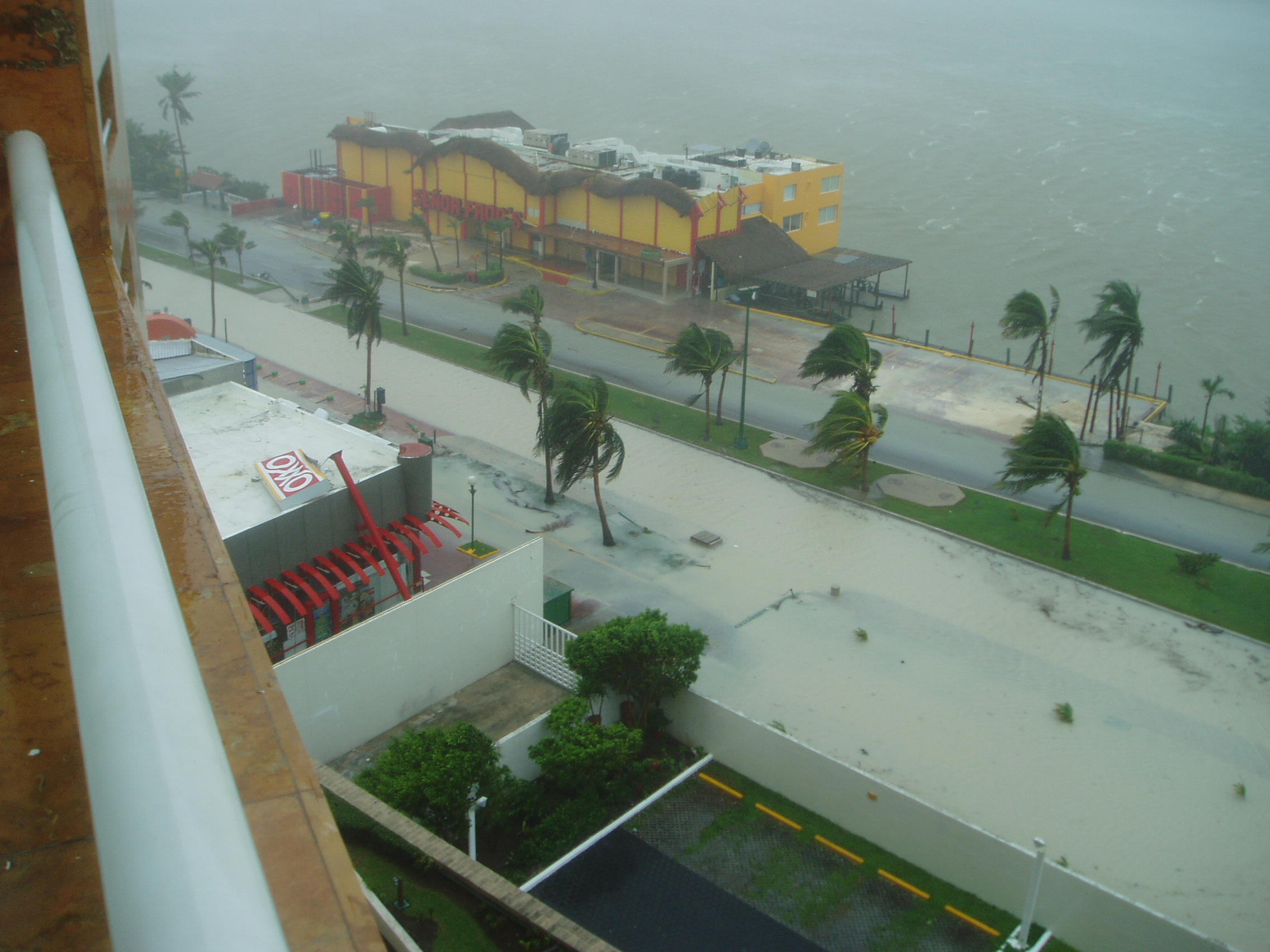
Kevin (CancunKev) from Cancun:

I have been opening my hurricane shutters hour by hour to check and see the storms progression here in the heart of the hotel zone in Cancun. We started to receive Hurricane force winds early this morning around 2 AM, and at this point Kukuklcan Blvd is under anywhere from 1 to 3 feet of water, at least from were we are in Maralago, about 2 blocks from Coco Bongo, The CITY, The Forum Shopping Mall, etc.

On the ocean side the waves look to be around 10 feet at this point with about 5 feet of surge. There is NO beach left as far as I can see, and the destruction is only going to continue.

I have attached a few photos, and will continue hour by hour until the power goes out. We do have generators in the building but I am not sure if they will be used as if the garage floods, the generators may cause for harm then good.

"See" you in about an hour....

CancunKev

Attachment: PA210030.JPG
Description: JPEG image

Attachment: PA210029.JPG
Description: JPEG image

Attachment: PA210028.JPG
Description: JPEG image

Attachment: PA210027.JPG
Description: JPEG image

Attachment: PA210025.JPG
Description: JPEG image

Mike Hobson Report
From: "gene" <genemb at bellsouth.net>
Date: Fri, 21 Oct 2005 12:29:25 -0500

Wow!

Since the last report the storm surge here I estimate to be about 10 feet! Cars are floating by!

Our downstairs toilets are "bubbling" which means the water level has reached the pipes! We may have to escape to the upstairs, but we are all ok!

Still no sign of our neighbors I mentioned!

Hopefully more later!

Mike


Image
0 likes   

curtadams
S2K Supporter
S2K Supporter
Posts: 1122
Joined: Sun Aug 28, 2005 7:57 pm
Location: Orange, California
Contact:

#2729 Postby curtadams » Fri Oct 21, 2005 1:09 pm

THead wrote:
Derek Ortt wrote:based upon the aircraft data, it appears as if Wilma reached land as a category 3 hurricane, with winds of 125 m.p.h. Not as bad as feared, but still worse than Roxanne of 1995

Surprised its not higher, her eye looks a bit clouded on vis, but looks near perfect on IR. Still a very healthy looking storm overall, in my amatuer opinion.
:wink:


She has double eyewalls - so effectively she's TWO Cat 3 storms, rather than one Cat 4-5. Plus the outer wall is very thick and the eye is large.
0 likes   

Derek Ortt

#2730 Postby Derek Ortt » Fri Oct 21, 2005 1:12 pm

there are no 140 m.p.h. winds in this cyclone. I am not sure why the intensity was kept that high. Due to the double eye, the pressure gradient has become flatter, which has created a larger area of 100KT winds
0 likes   

AZS
Tropical Storm
Tropical Storm
Posts: 117
Joined: Sun Sep 18, 2005 5:50 pm
Location: PD, Azores Islands, Portugal

#2731 Postby AZS » Fri Oct 21, 2005 1:13 pm

curtadams wrote:
THead wrote:
Derek Ortt wrote:based upon the aircraft data, it appears as if Wilma reached land as a category 3 hurricane, with winds of 125 m.p.h. Not as bad as feared, but still worse than Roxanne of 1995

Surprised its not higher, her eye looks a bit clouded on vis, but looks near perfect on IR. Still a very healthy looking storm overall, in my amatuer opinion.
:wink:


She has double eyewalls - so effectively she's TWO Cat 3 storms, rather than one Cat 4-5. Plus the outer wall is very thick and the eye is large.


She is a CAT 4.
Winds of 140 mph
926 mb

i don´t think we are looking at the same storm :roll:
0 likes   

shawn67
Tropical Storm
Tropical Storm
Posts: 143
Age: 58
Joined: Fri Jul 08, 2005 3:03 pm
Location: Fresno, CA

#2732 Postby shawn67 » Fri Oct 21, 2005 1:15 pm

Derek Ortt wrote:there are no 140 m.p.h. winds in this cyclone. I am not sure why the intensity was kept that high. Due to the double eye, the pressure gradient has become flatter, which has created a larger area of 100KT winds


So basically you are now saying you know more than the NHC.

Shawn
0 likes   

Wirbelsturm
Tropical Low
Tropical Low
Posts: 33
Joined: Mon Oct 17, 2005 11:06 am
Location: Central Kentucky

#2733 Postby Wirbelsturm » Fri Oct 21, 2005 1:16 pm

Thank God it's weakened to 115 mph! The damage won't be nearly as bad, since wind damage increases exponentially.
0 likes   

jkt21787
Category 5
Category 5
Posts: 2061
Joined: Tue Aug 31, 2004 5:27 pm
Location: Memphis, TN

#2734 Postby jkt21787 » Fri Oct 21, 2005 1:19 pm

Wirbelsturm wrote:Thank God it's weakened to 115 mph! The damage won't be nearly as bad, since wind damage increases exponentially.

That depends on whether you believe Derek or the NHC it seems...
0 likes   

SamSagnella
Category 2
Category 2
Posts: 630
Age: 39
Joined: Fri Aug 26, 2005 12:02 pm
Location: Westport, CT
Contact:

#2735 Postby SamSagnella » Fri Oct 21, 2005 1:19 pm

Derek Ortt wrote:there are no 140 m.p.h. winds in this cyclone. I am not sure why the intensity was kept that high. Due to the double eye, the pressure gradient has become flatter, which has created a larger area of 100KT winds


Exactly -- the double wind maxima is what has saved the NE Yucatan from a much stronger system (wind-wise). However, sustained major hurricane-force winds will be experienced for a significant period of time, so the overall damage inflicted shouldn't really be minimized much at all. I like the analogy of the two category 3s as opposed to one category 4/5...thats pretty much exactly what is happening.
0 likes   

6SpeedTA95
Category 5
Category 5
Posts: 1206
Joined: Wed Oct 19, 2005 3:25 pm
Location: Oklahoma
Contact:

#2736 Postby 6SpeedTA95 » Fri Oct 21, 2005 1:20 pm

Wirbelsturm wrote:Thank God it's weakened to 115 mph! The damage won't be nearly as bad, since wind damage increases exponentially.


Wind damage does increase exponentially but why are all these rumors floating around of it only beeing 100kts? The NHC is saying 140 mph and quite frankly the pressures would support that easily.
0 likes   

User avatar
artist
Category 5
Category 5
Posts: 9792
Joined: Mon Jun 06, 2005 3:26 pm
Location: West Palm

#2737 Postby artist » Fri Oct 21, 2005 1:21 pm

latest message - also more pics at the link, the first 2 are of them, the others are of the storm.

New Update and Photos (1 PM CDT)
From: "Kevin Alexander Murcko" <cancunkev at hotmail.com>
Date: Fri, 21 Oct 2005 13:11:19 -0600

First off I would like to thank everyone for their emails and well wishes, it means a lot, thanks.

I have snapped a few more photos of the "beach", the waves are starting to come in with greater force, and the winds have picked up.

The street side has a few more inches of water, but very similar conditions as my last report.

I heard from a friend in Downtown, and he tells me his phone and electricity is out, and that the noise of the wind winding through their apartment building is "amazing".

I also herd back from a client in Playa del Carmen. He tells me basically the same story, and that he will try and stay in touch by cell phone as long as he can. Flood waters are about 10 feet from his home and he has moved all furniture etc. up on the second floor.

More to come....


http://www.stormcarib.com/reports/2005/mexico.shtml
0 likes   

LanceW
Tropical Depression
Tropical Depression
Posts: 89
Joined: Wed Aug 24, 2005 12:09 pm
Location: Poinciana FL

#2738 Postby LanceW » Fri Oct 21, 2005 1:22 pm

AZS wrote:
curtadams wrote:
THead wrote:
Derek Ortt wrote:based upon the aircraft data, it appears as if Wilma reached land as a category 3 hurricane, with winds of 125 m.p.h. Not as bad as feared, but still worse than Roxanne of 1995

Surprised its not higher, her eye looks a bit clouded on vis, but looks near perfect on IR. Still a very healthy looking storm overall, in my amatuer opinion.
:wink:


She has double eyewalls - so effectively she's TWO Cat 3 storms, rather than one Cat 4-5. Plus the outer wall is very thick and the eye is large.


She is a CAT 4.
Winds of 140 mph
926 mb

i don´t think we are looking at the same storm :roll:


Well, RECON confirms what Derek said, winds of 120 MPH or so.
0 likes   

markymark8
Tropical Storm
Tropical Storm
Posts: 111
Joined: Sat Oct 08, 2005 11:57 am
Location: North Carolina

#2739 Postby markymark8 » Fri Oct 21, 2005 1:22 pm

Wirbelsturm wrote:Thank God it's weakened to 115 mph! The damage won't be nearly as bad, since wind damage increases exponentially.
If she has dropped to 115 mph winds she will be nothing but a wimpy storm when she hits Florida. She wont even be as strong as Katrina most likeley now when she hit Florida. I dont think florida is going to have to worry about hardly anything. There will be Hurricane veterens sitting out on their porch watching this one. It will be like a summer severe thunderstorm to them.
Last edited by markymark8 on Fri Oct 21, 2005 1:24 pm, edited 1 time in total.
0 likes   

User avatar
linkerweather
Professional-Met
Professional-Met
Posts: 261
Joined: Sat Jul 23, 2005 5:59 am
Location: tampa bay area

#2740 Postby linkerweather » Fri Oct 21, 2005 1:23 pm

And recon dropsonde measured 118kt in the eyewall....so 118x1.1507=135.8 mph
0 likes   


Return to “2005”

Who is online

Users browsing this forum: No registered users and 8 guests