Tropical Storm Ophelia
Moderator: S2k Moderators

-
Blown Away

- S2K Supporter

- Posts: 10253
- Joined: Wed May 26, 2004 6:17 am
I know it's the BAM Medium, but it's the first model to show the SW movement back towards SFL! I guess we will have to see if the others start showing the same! The only concern I have is the forecasts have anticipated slight N movement since last night! I've only noticed 28.9 at
5pm yesterday and 28.6 at 11am today, that's S! That BAM doesn't show as much E movement as the other models before turning SW. I think the other models have anticipated a little more N or E movement by now! Just an observation!
5pm yesterday and 28.6 at 11am today, that's S! That BAM doesn't show as much E movement as the other models before turning SW. I think the other models have anticipated a little more N or E movement by now! Just an observation!
0 likes
-
BensonTCwatcher

- Category 5

- Posts: 1050
- Joined: Sat Aug 28, 2004 10:11 pm
- Location: Southport NC
Well, Ophelia is an interesting lady.
That Accuweather track is not all that ridiculous.
I have been thinking for a couple days now that we will see 1 of two general possibilities. No way I am going to put my guess out there specifically as to the track. Way too many variables. But since this is the place for reasonable guesses based on observations, science etc. I'll go out on limb at the risk of being very wrong on this one. Here goes:
NOTE: NOT AN OFFICAL FORECAST. SEE s2K disclaimer and refer to the NHC for OFFICAL INFORMATION.
General solution 1
The ridge trapping that is taking place is somewhat rare for TC's. It does happen, but it takes just right conditions to keep a storm stationary. Given that fact, and the fact that it has been stationary for a while, it is likely that the ridge to the west will shift to allow a overall motion to begin soon. I am not an expert, so, I am looking for a global scale influence on the N or W side of the ridge to Ophelia's west to shift it east and cause Ophelia to move ENE overall consistent with the NHC track for the next 24-36 hours.

After that 36+ hours I expect that the massive mid atlantic ridge will bulge westward as it appears to starting to now. The anticyclone between Ophelia and Nate looks like it is joining and this will cause a slingshot like movement to Ophelia bringing her near the GA coast. By that time the ridge center over OK, will have shifted east as depicted by the GFS. This will move Ophelia NE near Myrtle Beach SC.
Landfall under this scenario would be in NC due to the coastline shape and it would be trying to re-curve.
General Solution 2
The same synoptic changes apply here but much sooner causing the system to re-curve well shy of the EC. It may waggle S on this track but I don't buy the loop back under any scenario at this point.
Since this is low confidence, I thought I would just put it out there for discussion while wait to see what she will do
That Accuweather track is not all that ridiculous.
I have been thinking for a couple days now that we will see 1 of two general possibilities. No way I am going to put my guess out there specifically as to the track. Way too many variables. But since this is the place for reasonable guesses based on observations, science etc. I'll go out on limb at the risk of being very wrong on this one. Here goes:
NOTE: NOT AN OFFICAL FORECAST. SEE s2K disclaimer and refer to the NHC for OFFICAL INFORMATION.
General solution 1
The ridge trapping that is taking place is somewhat rare for TC's. It does happen, but it takes just right conditions to keep a storm stationary. Given that fact, and the fact that it has been stationary for a while, it is likely that the ridge to the west will shift to allow a overall motion to begin soon. I am not an expert, so, I am looking for a global scale influence on the N or W side of the ridge to Ophelia's west to shift it east and cause Ophelia to move ENE overall consistent with the NHC track for the next 24-36 hours.
After that 36+ hours I expect that the massive mid atlantic ridge will bulge westward as it appears to starting to now. The anticyclone between Ophelia and Nate looks like it is joining and this will cause a slingshot like movement to Ophelia bringing her near the GA coast. By that time the ridge center over OK, will have shifted east as depicted by the GFS. This will move Ophelia NE near Myrtle Beach SC.
Landfall under this scenario would be in NC due to the coastline shape and it would be trying to re-curve.
General Solution 2
The same synoptic changes apply here but much sooner causing the system to re-curve well shy of the EC. It may waggle S on this track but I don't buy the loop back under any scenario at this point.
Since this is low confidence, I thought I would just put it out there for discussion while wait to see what she will do
0 likes
-
Canelaw99

- S2K Supporter
- Posts: 2128
- Age: 49
- Joined: Tue Aug 31, 2004 8:27 am
- Location: Homestead, FL
I agree with ya - the BAM is the first, and hopefully an outlier. I know you can't always trust it, but it's changed it's tune in the last day or so. Our local mets have basically told us to keep an eye on it as we are still in the southern tip of the 5 day cone. No one mentioned the slight southerly dip this morning though, and I sure haven't seen this northerly/northeasterly trek she's supposed to be on.....time will tell ultimately though 
0 likes


Here WFTV has the offical movement of drifting SW since 8PM, about 22 miles. Not using their inhouse model so far, already severe beach erosion already for a "weak" system.Canelaw99 wrote:I agree with ya - the BAM is the first, and hopefully an outlier. I know you can't always trust it, but it's changed it's tune in the last day or so. Our local mets have basically told us to keep an eye on it as we are still in the southern tip of the 5 day cone. No one mentioned the slight southerly dip this morning though, and I sure haven't seen this northerly/northeasterly trek she's supposed to be on.....time will tell ultimately though
0 likes
IMO its all about ratings.My local met in NC started his bit with a catch phrase right before a commercial. he said "our weather going downhill the weekend as ophelia edges closer" and he just shrugged his shoulders.Even if she did move this way she is a good ways out still but he had to get people to come back after the break.Just sensationalism!
Officially she is stationary and the NHC is the only group that matters at this point.
On radar either the west edge of the center filled in or she moved a hair the ENE but overall i say she is stationary!
Officially she is stationary and the NHC is the only group that matters at this point.
On radar either the west edge of the center filled in or she moved a hair the ENE but overall i say she is stationary!
0 likes
-
deltadog03

- Professional-Met

- Posts: 3580
- Joined: Tue Jul 05, 2005 6:16 pm
- Location: Macon, GA
-
ameriwx2003

- Category 4

- Posts: 980
- Joined: Tue Jul 22, 2003 10:45 am
Wow.... the 12Z GFS has dropped the out to Sea scenario and has a Major Hurricane at 180 Hrs just offshore the Carolinas after moving NE then looping back toward the Coast.. IMHO the GFS is still taking Ophelia to far East before Turning back... we will see.
http://www.nco.ncep.noaa.gov/pmb/nwprod ... _fpc.shtml
http://www.nco.ncep.noaa.gov/pmb/nwprod ... _fpc.shtml
0 likes
-
x-y-no

- Category 5
- Posts: 8359
- Age: 65
- Joined: Wed Aug 11, 2004 12:14 pm
- Location: Fort Lauderdale, FL
ameriwx2003 wrote:Wow.... the 12Z GFS has dropped the out to Sea scenario and has a Major Hurricane at 180 Hrs just offshore the Carolinas after moving NE then looping back toward the Coast.. IMHO the GFS is still taking Ophelia to far East before Turning back... we will see.
http://www.nco.ncep.noaa.gov/pmb/nwprod ... _fpc.shtml
Beat me to it ... I was just about to post that.
Note that after 180 hours, it stalls the storm again, right off the Carolinas coast for a couple of days before eventually taking it ashore just before it's picked up by a trough.
0 likes
-
deltadog03
- Professional-Met
- Posts: 3580
- Joined: Tue Jul 05, 2005 6:16 pm
- Location: Macon, GA
-
feederband

- S2K Supporter
- Posts: 3423
- Joined: Wed Oct 01, 2003 6:21 pm
- Location: Lakeland Fl
-
DESTRUCTION5

- Category 5
- Posts: 4430
- Age: 44
- Joined: Wed Sep 03, 2003 11:25 am
- Location: Stuart, FL
-
MiamiensisWx
Appears to be looking better on both visible and infra-red imagery.
Visible:
http://www.ssd.noaa.gov/PS/TROP/DATA/RT/FLOAT/VIS/20.jpg
Infra-red:
http://www.ssd.noaa.gov/PS/TROP/DATA/RT/FLOAT/IR4/20.jpg
Now has a good convective burst and a seemingly gradually improving overall shape.
Visible:
http://www.ssd.noaa.gov/PS/TROP/DATA/RT/FLOAT/VIS/20.jpg
Infra-red:
http://www.ssd.noaa.gov/PS/TROP/DATA/RT/FLOAT/IR4/20.jpg
Now has a good convective burst and a seemingly gradually improving overall shape.
0 likes
-
ameriwx2003
- Category 4
- Posts: 980
- Joined: Tue Jul 22, 2003 10:45 am
12Z NOGAPS contnues the Loop back West trend as well..
https://www.fnmoc.navy.mil/CGI/PUBLIC/w ... rp&tau=144
https://www.fnmoc.navy.mil/CGI/PUBLIC/w ... rp&tau=144
0 likes
-
ameriwx2003
- Category 4
- Posts: 980
- Joined: Tue Jul 22, 2003 10:45 am
GFDL is much quicker in bringing Ophelia back West and has it landfalling about the GA/FL border around the 78-84 Hour time frame.. Scroll to the bottom of page at link below for Ophelia.
http://twister.sbs.ohio-state.edu/text/ ... s/05090817
http://twister.sbs.ohio-state.edu/text/ ... s/05090817
Last edited by ameriwx2003 on Thu Sep 08, 2005 12:45 pm, edited 1 time in total.
0 likes
 The models have moved much tighter together. Look at the GFDL now.
-
Brent
- S2K Supporter
- Posts: 38717
- Age: 37
- Joined: Sun May 16, 2004 10:30 pm
- Location: Tulsa Oklahoma
- Contact:
BULLETIN
TROPICAL STORM OPHELIA INTERMEDIATE ADVISORY NUMBER 9A
NWS TPC/NATIONAL HURRICANE CENTER MIAMI FL
2 PM EDT THU SEP 08 2005
...OPHELIA GRADUALLY STRENGTHENING WHILE REMAINING NEARLY
STATIONARY...
A TROPICAL STORM WARNING REMAINS IN EFFECT FOR THE EAST COAST OF
FLORIDA FROM COCOA BEACH NORTHWARD TO FLAGLER BEACH. A TROPICAL
STORM WARNING MEANS THAT TROPICAL STORM CONDITIONS ARE EXPECTED
WITHIN THE WARNING AREA WITHIN THE NEXT 24 HOURS.
A TROPICAL STORM WATCH REMAINS IN EFFECT FOR THE NORTHEAST FLORIDA
COAST FROM NORTH OF FLAGLER BEACH TO FERNANDINA BEACH. A TROPICAL
STORM WATCH MEANS THAT TROPICAL STORM CONDITIONS ARE POSSIBLE
WITHIN THE WATCH AREA WITHIN THE NEXT 36 HOURS.
INTERESTS ELSEWHERE IN NORTHERN AND CENTRAL FLORIDA...AND THE
SOUTHEASTERN UNITED STATES COAST SHOULD MONITOR THE PROGRESS OF
THIS SYSTEM.
FOR STORM INFORMATION SPECIFIC TO YOUR AREA...INCLUDING POSSIBLE
INLAND WATCHES AND WARNINGS...PLEASE MONITOR PRODUCTS ISSUED
BY YOUR LOCAL WEATHER OFFICE.
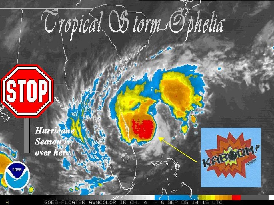
AT 2 PM EDT...1800Z...THE CENTER OF TROPICAL STORM OPHELIA WAS
LOCATED NEAR LATITUDE 28.6 NORTH... LONGITUDE 79.5 WEST OR ABOUT 70
MILES EAST-NORTHEAST OF CAPE CANAVERAL FLORIDA.
OPHELIA IS STATIONARY AND LITTLE OVERALL MOVEMENT IS EXPECTED TODAY.
MAXIMUM SUSTAINED WINDS ARE NEAR 65 MPH WITH HIGHER GUSTS. SOME
STRENGTHENING IS FORECAST...AND OPHELIA COULD BECOME A HURRICANE
DURING THE NEXT 24 HOURS.
TROPICAL STORM FORCE WINDS EXTEND OUTWARD UP TO 70 MILES FROM THE
CENTER. RAIN BANDS WITH STRONG WINDS IN SQUALLS HAVE BEEN
SPREADING OVER PORTIONS OF THE FLORIDA EAST COAST IN THE TROPICAL
STORM WARNING AREA.
AN AIR FORCE HURRICANE HUNTER PLANE JUST REPORTED A MINIMUM CENTRAL
PRESSURE OF 990 MB...29.23 INCHES.
OPHELIA IS EXPECTED TO PRODUCE TOTAL RAINFALL ACCUMULATIONS OF 1 TO
3 INCHES ACROSS PORTIONS OF CENTRAL AND NORTHERN FLORIDA...AND
SOUTHEASTERN GEORGIA...WITH ISOLATED MAXIMUM AMOUNTS OF UP TO 5
INCHES.
REPEATING THE 2 PM EDT POSITION...28.6 N... 79.5 W. MOVEMENT
...STATIONARY. MAXIMUM SUSTAINED WINDS... 65 MPH. MINIMUM CENTRAL
PRESSURE... 990 MB.
THE NEXT ADVISORY WILL BE ISSUED BY THE NATIONAL HURRICANE CENTER AT
5 PM EDT.
FORECASTER PASCH
TROPICAL STORM OPHELIA INTERMEDIATE ADVISORY NUMBER 9A
NWS TPC/NATIONAL HURRICANE CENTER MIAMI FL
2 PM EDT THU SEP 08 2005
...OPHELIA GRADUALLY STRENGTHENING WHILE REMAINING NEARLY
STATIONARY...
A TROPICAL STORM WARNING REMAINS IN EFFECT FOR THE EAST COAST OF
FLORIDA FROM COCOA BEACH NORTHWARD TO FLAGLER BEACH. A TROPICAL
STORM WARNING MEANS THAT TROPICAL STORM CONDITIONS ARE EXPECTED
WITHIN THE WARNING AREA WITHIN THE NEXT 24 HOURS.
A TROPICAL STORM WATCH REMAINS IN EFFECT FOR THE NORTHEAST FLORIDA
COAST FROM NORTH OF FLAGLER BEACH TO FERNANDINA BEACH. A TROPICAL
STORM WATCH MEANS THAT TROPICAL STORM CONDITIONS ARE POSSIBLE
WITHIN THE WATCH AREA WITHIN THE NEXT 36 HOURS.
INTERESTS ELSEWHERE IN NORTHERN AND CENTRAL FLORIDA...AND THE
SOUTHEASTERN UNITED STATES COAST SHOULD MONITOR THE PROGRESS OF
THIS SYSTEM.
FOR STORM INFORMATION SPECIFIC TO YOUR AREA...INCLUDING POSSIBLE
INLAND WATCHES AND WARNINGS...PLEASE MONITOR PRODUCTS ISSUED
BY YOUR LOCAL WEATHER OFFICE.
AT 2 PM EDT...1800Z...THE CENTER OF TROPICAL STORM OPHELIA WAS
LOCATED NEAR LATITUDE 28.6 NORTH... LONGITUDE 79.5 WEST OR ABOUT 70
MILES EAST-NORTHEAST OF CAPE CANAVERAL FLORIDA.
OPHELIA IS STATIONARY AND LITTLE OVERALL MOVEMENT IS EXPECTED TODAY.
MAXIMUM SUSTAINED WINDS ARE NEAR 65 MPH WITH HIGHER GUSTS. SOME
STRENGTHENING IS FORECAST...AND OPHELIA COULD BECOME A HURRICANE
DURING THE NEXT 24 HOURS.
TROPICAL STORM FORCE WINDS EXTEND OUTWARD UP TO 70 MILES FROM THE
CENTER. RAIN BANDS WITH STRONG WINDS IN SQUALLS HAVE BEEN
SPREADING OVER PORTIONS OF THE FLORIDA EAST COAST IN THE TROPICAL
STORM WARNING AREA.
AN AIR FORCE HURRICANE HUNTER PLANE JUST REPORTED A MINIMUM CENTRAL
PRESSURE OF 990 MB...29.23 INCHES.
OPHELIA IS EXPECTED TO PRODUCE TOTAL RAINFALL ACCUMULATIONS OF 1 TO
3 INCHES ACROSS PORTIONS OF CENTRAL AND NORTHERN FLORIDA...AND
SOUTHEASTERN GEORGIA...WITH ISOLATED MAXIMUM AMOUNTS OF UP TO 5
INCHES.
REPEATING THE 2 PM EDT POSITION...28.6 N... 79.5 W. MOVEMENT
...STATIONARY. MAXIMUM SUSTAINED WINDS... 65 MPH. MINIMUM CENTRAL
PRESSURE... 990 MB.
THE NEXT ADVISORY WILL BE ISSUED BY THE NATIONAL HURRICANE CENTER AT
5 PM EDT.
FORECASTER PASCH
0 likes
#neversummer
Who is online
Users browsing this forum: No registered users and 2 guests