ATL: IAN - Post-Tropical - Discussion
Moderator: S2k Moderators
-
- Category 2
- Posts: 514
- Joined: Fri Oct 11, 2019 11:35 pm
- Iceresistance
- Category 5
- Posts: 8912
- Age: 20
- Joined: Sat Oct 10, 2020 9:45 am
- Location: Tecumseh, OK/Norman, OK
Re: ATL: IAN - Tropical Storm - Discussion
Keldeo1997 wrote:https://cdn.discordapp.com/attachments/1021831616605200516/1023733344606883890/Screenshot_132.png
Got a Eyewall
Oh my goodness, that eyewall is extremely tiny!
2 likes
Bill 2015 & Beta 2020
Winter 2020-2021
All observations are in Tecumseh, OK unless otherwise noted.
Winter posts are focused mainly for Oklahoma & Texas.
Take any of my forecasts with a grain of salt, refer to the NWS, SPC, and NHC for official information
Never say Never with weather! Because ANYTHING is possible!
Winter 2020-2021
All observations are in Tecumseh, OK unless otherwise noted.
Winter posts are focused mainly for Oklahoma & Texas.
Take any of my forecasts with a grain of salt, refer to the NWS, SPC, and NHC for official information
Never say Never with weather! Because ANYTHING is possible!
Re: ATL: IAN - Tropical Storm - Discussion
1000x this. Shallow convection has clearly done the work of intensifying Ian into a shallow and small, but also robust, vortex.
What stands out to me is that dropsonde profiles suggests that Ian is not fully stacked (much closer than this morning), and that some of the SFMR readings are stronger than FL winds (though those readings may be rain-contaminated). This isn't because of shear, but because +PV in the mid-levels is generated by deep convection and there hasn't been enough of that to couple the mid-level wind field with the surface vortex. I really have no clue why Ian has taken so long to fire off deep convection, but it looks like it is beginning to now and so any appearance of misalignment should be taken care of in the next few hours.
https://twitter.com/webberweather/status/1574169603147587585
9 likes
I'm an busy grad student, not a professional forecaster. Please refer to the NHC and NWS for official forecasts.
Re: ATL: IAN - Tropical Storm - Discussion
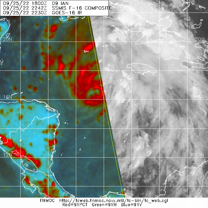
ThetaE wrote:1000x this. Shallow convection has clearly done the work of intensifying Ian into a shallow and small, but also robust, vortex.
What stands out to me is that dropsonde profiles suggests that Ian is not fully stacked (much closer than this morning), and that some of the SFMR readings are stronger than FL winds (though those readings may be rain-contaminated). This isn't because of shear, but because +PV in the mid-levels is generated by deep convection and there hasn't been enough of that to couple the mid-level wind field with the surface vortex. I really have no clue why Ian has taken so long to fire off deep convection, but it looks like it is beginning to now and so any appearance of misalignment should be taken care of in the next few hours.
https://twitter.com/webberweather/status/1574169603147587585
I believe Webb meant "sufficient but not necessary", not "necessary but not sufficient". The latter suggests you NEED deep convection for intensification but it might not be enough, which is the exact opposite of what's happening.
5 likes
Re: ATL: IAN - Tropical Storm - Discussion
Too me, the big and consequential aspect of finding the pressure so much lower than expected, is that this system may well get the chance to successfully conclude an EWC and get bigger and intensify further, increasing the chances of a hard cat-3+ landfall.
2 likes
- Hypercane_Kyle
- Category 5
- Posts: 2899
- Joined: Sat Mar 07, 2015 7:58 pm
- Location: Cape Canaveral, FL
Re: ATL: IAN - Tropical Storm - Discussion
Very dramatic improvements on the recon. Pressures have dropped to about 990 mb with the VDM showing an eyewall developing.
Ian is well on its way to hurricane status.
7 likes
My posts are my own personal opinion, defer to the National Hurricane Center (NHC) and other NOAA products for decision making during hurricane season.
- StPeteMike
- Category 1
- Posts: 357
- Joined: Thu Jun 07, 2018 11:26 pm
Re: ATL: IAN - Tropical Storm - Discussion
Such a small core doesn't question the chance we could get a Cat 4 before landfall around 21.8 N/84.4 W.
3 likes
The above post is not official and should not be used as such. It is the opinion of the poster and may or may not be backed by sound meteorological data. It is not endorsed by any professional institution or storm2k.org. For official information, please refer to the NHC and NWS products.
Re: ATL: IAN - Tropical Storm - Discussion
Last edited by Torgo on Sun Sep 25, 2022 6:28 pm, edited 3 times in total.
2 likes
Re: ATL: IAN - Tropical Storm - Discussion
THERE's the big convective burst!
The eyewall was open to the W when recon made the pass. I suspect this will close off the eyewall in no time.
8 likes
- ScottNAtlanta
- Category 5
- Posts: 1998
- Joined: Sat May 25, 2013 3:11 pm
- Location: Atlanta, GA
Re: ATL: IAN - Tropical Storm - Discussion
There is a 4 degree (C) variance in the eye temperature (in and out). When it's really ready to crank that difference will be much higher (for example it was about 10 degrees (C) when Fiona was cranking).
Last edited by ScottNAtlanta on Sun Sep 25, 2022 6:27 pm, edited 1 time in total.
3 likes
The posts in this forum are NOT official forecast and should not be used as such. They are just the opinion of the poster and may or may not be backed by sound meteorological data. They are NOT endorsed by any professional institution or storm2k.org. For official information, please refer to the NHC and NWS products.
- InfernoFlameCat
- Category 5
- Posts: 1966
- Age: 21
- Joined: Mon Dec 14, 2020 10:52 am
- Location: Buford, GA
Re: ATL: IAN - Tropical Storm - Discussion
I think we could see extreme rapid intensification shortly. With a closed or near closed eyewall, as well as it being a pinhole, we might see something like Wilma or Delta in terms of strengthening.
9 likes
I am by no means a professional. DO NOT look at my forecasts for official information or make decisions based on what I post.
Goal: to become a registered expert over tropical and subtropical cyclones.
-
- Admin
- Posts: 19165
- Age: 60
- Joined: Sun Aug 27, 2006 8:23 pm
- Location: Florence, KY (name is Mark)
Re: ATL: IAN - Tropical Storm - Discussion
5 likes
M a r k
- - - - -
Join us in chat: Storm2K Chatroom Invite. Android and IOS apps also available.
The posts in this forum are NOT official forecasts and should not be used as such. Posts are NOT endorsed by any professional institution or STORM2K.org. For official information and forecasts, please refer to NHC and NWS products.
- Iceresistance
- Category 5
- Posts: 8912
- Age: 20
- Joined: Sat Oct 10, 2020 9:45 am
- Location: Tecumseh, OK/Norman, OK
Re: ATL: IAN - Tropical Storm - Discussion
InfernoFlameCat wrote:I think we could see extreme rapid intensification shortly. With a closed or near closed eyewall, as well as it being a pinhole, we might see something like Wilma or Delta in terms of strengthening.
That eyewall is extremely tiny, it's just like a tornado! The tighter the pressure gradient, the faster the winds will become.
2 likes
Bill 2015 & Beta 2020
Winter 2020-2021
All observations are in Tecumseh, OK unless otherwise noted.
Winter posts are focused mainly for Oklahoma & Texas.
Take any of my forecasts with a grain of salt, refer to the NWS, SPC, and NHC for official information
Never say Never with weather! Because ANYTHING is possible!
Winter 2020-2021
All observations are in Tecumseh, OK unless otherwise noted.
Winter posts are focused mainly for Oklahoma & Texas.
Take any of my forecasts with a grain of salt, refer to the NWS, SPC, and NHC for official information
Never say Never with weather! Because ANYTHING is possible!
- ScottNAtlanta
- Category 5
- Posts: 1998
- Joined: Sat May 25, 2013 3:11 pm
- Location: Atlanta, GA
Re: ATL: IAN - Tropical Storm - Discussion
InfernoFlameCat wrote:I think we could see extreme rapid intensification shortly. With a closed or near closed eyewall, as well as it being a pinhole, we might see something like Wilma or Delta in terms of strengthening.
What you will probably see is an EWRC sooner rather than later. Recon said 18 miles...that's small but hardly remarkable
Wilma...fyi was 8 at it's smallest.
3 likes
The posts in this forum are NOT official forecast and should not be used as such. They are just the opinion of the poster and may or may not be backed by sound meteorological data. They are NOT endorsed by any professional institution or storm2k.org. For official information, please refer to the NHC and NWS products.
Re: ATL: IAN - Tropical Storm - Discussion
ScottNAtlanta wrote:InfernoFlameCat wrote:I think we could see extreme rapid intensification shortly. With a closed or near closed eyewall, as well as it being a pinhole, we might see something like Wilma or Delta in terms of strengthening.
What you will probably see is an EWRC sooner rather than later. Recon said 18 miles...that's small but hardly remarkable
Wilma...fyi was 8 at it's smallest.
Based on the microwave pass above, I think we’ll see a bit of an eyewall meld, with the W gap in the current eyewall being filled it by one of the outer bands.
1 likes
Irene '11 Sandy '12 Hermine '16 5/15/2018 Derecho Fay '20 Isaias '20 Elsa '21 Henri '21 Ida '21
I am only a meteorology enthusiast who knows a decent amount about tropical cyclones. Look to the professional mets, the NHC, or your local weather office for the best information.
Re: ATL: IAN - Tropical Storm - Discussion
I don't want to jump the hype bandwagon, but Ian is looking extremely primed for RI right now. Chances are it has already begun (next recon pass will indicate how fast it's deepening). Idk about Wilma-level deepening like was suggested earlier in this thread (Wilma's ERI is pretty much unique in the Atlantic basin), but I can imagine this could go Delta. Exciting hours for a hurricane watcher, but also very anxious hours for anyone in Ian's path. Stay safe everyone and prepare!
1 likes
- InfernoFlameCat
- Category 5
- Posts: 1966
- Age: 21
- Joined: Mon Dec 14, 2020 10:52 am
- Location: Buford, GA
Re: ATL: IAN - Tropical Storm - Discussion
ScottNAtlanta wrote:InfernoFlameCat wrote:I think we could see extreme rapid intensification shortly. With a closed or near closed eyewall, as well as it being a pinhole, we might see something like Wilma or Delta in terms of strengthening.
What you will probably see is an EWRC sooner rather than later. Recon said 18 miles...that's small but hardly remarkable
Wilma...fyi was 8 at it's smallest.
I misread the VDM. thanks. Thought it said 8
2 likes
I am by no means a professional. DO NOT look at my forecasts for official information or make decisions based on what I post.
Goal: to become a registered expert over tropical and subtropical cyclones.
- Iceresistance
- Category 5
- Posts: 8912
- Age: 20
- Joined: Sat Oct 10, 2020 9:45 am
- Location: Tecumseh, OK/Norman, OK
Re: ATL: IAN - Tropical Storm - Discussion
AJC3 wrote:C18 isn't a pinhole eye, gang.
A pinhole eye must have a circular diameter of less than 10 miles. This is not a pinhole eye like you mentioned, but a tiny one indeed.
2 likes
Bill 2015 & Beta 2020
Winter 2020-2021
All observations are in Tecumseh, OK unless otherwise noted.
Winter posts are focused mainly for Oklahoma & Texas.
Take any of my forecasts with a grain of salt, refer to the NWS, SPC, and NHC for official information
Never say Never with weather! Because ANYTHING is possible!
Winter 2020-2021
All observations are in Tecumseh, OK unless otherwise noted.
Winter posts are focused mainly for Oklahoma & Texas.
Take any of my forecasts with a grain of salt, refer to the NWS, SPC, and NHC for official information
Never say Never with weather! Because ANYTHING is possible!
Who is online
Users browsing this forum: No registered users and 59 guests