ATL: IAN - Models

Moderator: S2k Moderators

Message
Author
User avatar
jdray
Category 3
Category 3
Posts: 846
Joined: Tue Aug 31, 2004 10:07 pm
Location: NE Florida

Re: ATL: IAN - Models

#2741 Postby jdray » Mon Sep 26, 2022 9:52 am

The QPC 7Day is forecasting some heavy rain. I'm currently looking at a potential 15 inches+ right now up here near Jacksonville.
Image

NWS JAX is forecasting 6-12 inches as well.

Area Forecast Discussion
National Weather Service Jacksonville FL
905 AM EDT Mon Sep 26 2022

..................................
.HYDROLOGY...
Issued at 253 AM EDT Mon Sep 26 2022

Models are in general agreement with rainfall totals of 6-12
inches through the end of the week with Ian, with highest amounts
across coastal NE FL where strong low level convergent bands will
form, and another maximum expected closer to the eventual track of
Ian after it comes onshore and tracks through the Suwannee Valley
and into inland SE GA. Localized higher amounts can be expected
and other than the usual flash flooding threat on Wed/Thu/Fri,
expect significant river rises and main focus will be on most NE
FL basins, since they remain higher from heavy rainfall over the
past 2 months, with the Santa Fe still in Action/Elevated stages
at the moment, although the expected rainfall amounts will likely
bring potential for flooding on Black Creek, St Mary`s and
Suwannee Basins as well. A combination of trapped high tides and
fresh water flooding is also expected on the St Johns River and in
addition to likely Flood Watches from Wed through Fri, the St
Johns River Basin will likely need Coastal Flood Watches as well
4 likes   

Fancy1001
Category 1
Category 1
Posts: 452
Joined: Thu Jul 16, 2020 10:16 pm

Re: ATL: IAN - Models

#2742 Postby Fancy1001 » Mon Sep 26, 2022 9:59 am

Icon running a little stronger and a little southwest.
Last edited by Fancy1001 on Mon Sep 26, 2022 9:59 am, edited 1 time in total.
1 likes   

User avatar
chris_fit
Category 5
Category 5
Posts: 3078
Joined: Wed Sep 10, 2003 11:58 pm
Location: Tampa Bay Area, FL
Contact:

Re: ATL: IAN - Models

#2743 Postby chris_fit » Mon Sep 26, 2022 9:59 am

12Z Models have begun. ICON coming in... slightly slower.

Image
1 likes   

Fancy1001
Category 1
Category 1
Posts: 452
Joined: Thu Jul 16, 2020 10:16 pm

Re: ATL: IAN - Models

#2744 Postby Fancy1001 » Mon Sep 26, 2022 10:00 am

chris_fit wrote:12Z Models have begun. ICON coming in... slightly slower.

https://i.imgur.com/3ltShA9.png

Where are you getting your models from, tropical tidbits is a bit slow on the update.
1 likes   

SconnieCane
Category 4
Category 4
Posts: 913
Joined: Thu Aug 02, 2018 5:29 pm
Location: Madison, WI

Re: ATL: IAN - Models

#2745 Postby SconnieCane » Mon Sep 26, 2022 10:00 am

cane5 wrote:
skillz305 wrote:Is it me or are more of the models showing a crossing central Florida track? Per 12z model track guidance


Sorry for the ignorance is 12z the German model ?


12Z is a time at which model runs are initialized...equivalent to 0700 CDT. The German model is the ICON.
1 likes   

User avatar
chris_fit
Category 5
Category 5
Posts: 3078
Joined: Wed Sep 10, 2003 11:58 pm
Location: Tampa Bay Area, FL
Contact:

Re: ATL: IAN - Models

#2746 Postby chris_fit » Mon Sep 26, 2022 10:01 am

Stronger, but more W. Slowing down, gonna be close.


Image
1 likes   

User avatar
chris_fit
Category 5
Category 5
Posts: 3078
Joined: Wed Sep 10, 2003 11:58 pm
Location: Tampa Bay Area, FL
Contact:

Re: ATL: IAN - Models

#2747 Postby chris_fit » Mon Sep 26, 2022 10:03 am

Goodness, catastrophe if this pans out...

Image
2 likes   

User avatar
chris_fit
Category 5
Category 5
Posts: 3078
Joined: Wed Sep 10, 2003 11:58 pm
Location: Tampa Bay Area, FL
Contact:

Re: ATL: IAN - Models

#2748 Postby chris_fit » Mon Sep 26, 2022 10:05 am

And that's what the 12Z ICON wrote.... Slight left shift from previous runs, but stronger, still hits Tampa.

Image
1 likes   

User avatar
cheezyWXguy
Category 5
Category 5
Posts: 5529
Joined: Mon Feb 13, 2006 12:29 am
Location: Dallas, TX

Re: ATL: IAN - Models

#2749 Postby cheezyWXguy » Mon Sep 26, 2022 10:19 am

chris_fit wrote:And that's what the 12Z ICON wrote.... Slight left shift from previous runs, but stronger, still hits Tampa.

https://i.imgur.com/XOVQvtT.png

Pretty sure that’s worst case scenario right there. Good thing it’s only one run of one model, and the icon at that. Hopefully other models don’t match it, and still time for things to shift a bit
1 likes   

User avatar
kevin
Category 5
Category 5
Posts: 1768
Age: 25
Joined: Wed Aug 28, 2019 4:35 am

Re: ATL: IAN - Models

#2750 Postby kevin » Mon Sep 26, 2022 10:24 am

chris_fit wrote:Goodness, catastrophe if this pans out...

https://i.imgur.com/TFKmINJ.png


A high-end cat 3 or cat 4 into Tampa with the perfect angle for a historic storm surge. Let's hope it's just the ICON and that the other models are more offshore.
3 likes   

User avatar
SFLcane
S2K Supporter
S2K Supporter
Posts: 9606
Age: 46
Joined: Sat Jun 05, 2010 1:44 pm
Location: Lake Worth Florida

Re: ATL: IAN - Models

#2751 Postby SFLcane » Mon Sep 26, 2022 10:25 am

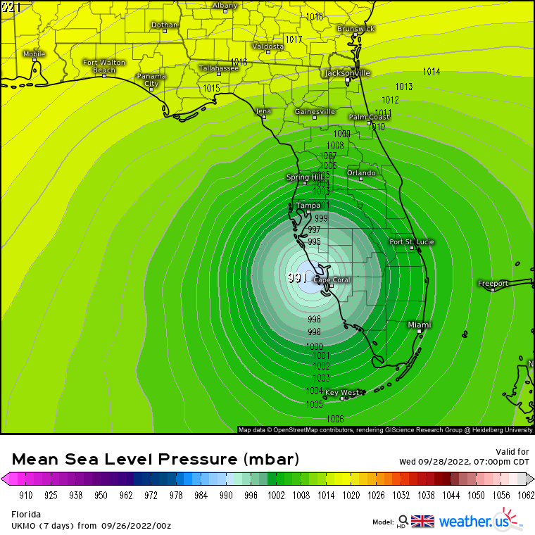
Was the 06z UKMET posted?
1 likes   

AutoPenalti
Category 5
Category 5
Posts: 3949
Age: 27
Joined: Mon Aug 17, 2015 4:16 pm
Location: Ft. Lauderdale, Florida

Re: ATL: IAN - Models

#2752 Postby AutoPenalti » Mon Sep 26, 2022 10:27 am

SFLcane wrote:Was the 06z UKMET posted?

No, what does it have?
1 likes   
The posts in this forum are NOT official forecasts and should not be used as such. They are just the opinion of the poster and may or may not be backed by sound meteorological data. They are NOT endorsed by any professional institution or STORM2K. For official information, please refer to products from the NHC and NWS.


Model Runs Cheat Sheet:
GFS (5:30 AM/PM, 11:30 AM/PM)
HWRF, GFDL, UKMET, NAVGEM (6:30-8:00 AM/PM, 12:30-2:00 AM/PM)
ECMWF (1:45 AM/PM)

TCVN
is a weighted averaged

User avatar
SFLcane
S2K Supporter
S2K Supporter
Posts: 9606
Age: 46
Joined: Sat Jun 05, 2010 1:44 pm
Location: Lake Worth Florida

Re: ATL: IAN - Models

#2753 Postby SFLcane » Mon Sep 26, 2022 10:29 am

AutoPenalti wrote:
SFLcane wrote:Was the 06z UKMET posted?

No, what does it have?


Image
2 likes   

Michele B
Category 4
Category 4
Posts: 906
Joined: Thu Aug 25, 2016 8:08 am
Location: SWFL

Re: ATL: IAN - Models

#2754 Postby Michele B » Mon Sep 26, 2022 10:31 am

skyline385 wrote:
skillz305 wrote:
LarryWx wrote:The 18Z UKMET at 60 is 40 miles ESE of the 12Z at 66.


Oh wow. Any visuals to that run?


Here is UKMET 12Z vs 12Z landfall vs18Z since the 06/18Z runs only go up to 60 hours

https://i.imgur.com/W5Mktai.jpg


That’s not Tampa.
1 likes   
Cleo - 1964, Betsy - 1965, David - 1979, Andrew - 1992, Charlie (Francis, Ivan, Jeanne) - 2004, Irma - 2017, Ian - 2022

User avatar
petit_bois
Tropical Storm
Tropical Storm
Posts: 227
Joined: Tue Jun 22, 2010 12:04 pm
Location: Petit Bois Island Mississippi

Re: ATL: IAN - Models

#2755 Postby petit_bois » Mon Sep 26, 2022 10:35 am

History suggests storms forecast to hit Tampa end up on the northern gulf coast... I don't like the number of models forcasting a slow down / stall off the Florida west coast. Elana did that...
2 likes   
Resident of the Atlantic Basin's Major Hurricane Hit Capital!
Camille (200+winds), Frederic, Goerges, Katrina... and many many more.

Disclaimer: I'm likely the smartest guy here... but I have no idea where a tropical cyclone will go. I suggest you take my opinion as a grain of salt. I suggest you look to the National Hurricane Center for accurate info.

MrJames
Tropical Storm
Tropical Storm
Posts: 183
Joined: Fri Sep 10, 2004 11:56 am
Location: Jax, FL

Re: ATL: IAN - Models

#2756 Postby MrJames » Mon Sep 26, 2022 10:36 am

SFLcane wrote:
AutoPenalti wrote:
SFLcane wrote:Was the 06z UKMET posted?

No, what does it have?


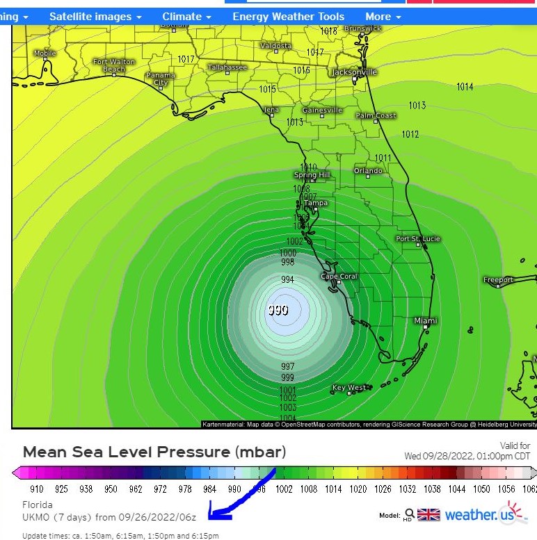
https://i.postimg.cc/Lsmfvn8F/ukmet.png


That is the 00z. I don't think the 06z goes out that far for the UKMET.
1 likes   

User avatar
skyline385
Category 5
Category 5
Posts: 2444
Age: 33
Joined: Wed Aug 26, 2020 11:15 pm
Location: Palm Beach County FL

Re: ATL: IAN - Models

#2757 Postby skyline385 » Mon Sep 26, 2022 10:37 am

Weak initialisation by 12Z GFS, 989mb at first timestep.


Sent from my iPhone using Tapatalk
1 likes   

User avatar
kevin
Category 5
Category 5
Posts: 1768
Age: 25
Joined: Wed Aug 28, 2019 4:35 am

Re: ATL: IAN - Models

#2758 Postby kevin » Mon Sep 26, 2022 10:43 am

Despite the weak initialization GFS is stronger at +18 hrs than the 06z run (971 vs 975 mb). Track so far almost identical.
0 likes   

User avatar
SFLcane
S2K Supporter
S2K Supporter
Posts: 9606
Age: 46
Joined: Sat Jun 05, 2010 1:44 pm
Location: Lake Worth Florida

Re: ATL: IAN - Models

#2759 Postby SFLcane » Mon Sep 26, 2022 10:43 am

MrJames wrote:
SFLcane wrote:
AutoPenalti wrote:No, what does it have?


https://i.postimg.cc/Lsmfvn8F/ukmet.png


That is the 00z. I don't think the 06z goes out that far for the UKMET.


Image
1 likes   

User avatar
kevin
Category 5
Category 5
Posts: 1768
Age: 25
Joined: Wed Aug 28, 2019 4:35 am

Re: ATL: IAN - Models

#2760 Postby kevin » Mon Sep 26, 2022 10:47 am

GFS+24 968 mb and perhaps a hair (about 0.2 degrees) further east than 06z.
1 likes   


Return to “2022”

Who is online

Users browsing this forum: No registered users and 68 guests