Current conditions at my house in Conway:
Pressure 986.7mb
Winds in the teens
Went outside a few minutes ago and watched a large branch fall out of one of our trees. Quite a few large branches down within a couple of blocks. Got run back into the house by a wall of rain.
ATL: IAN - Post-Tropical - Discussion
Moderator: S2k Moderators
-
Old-TimeCane

- Tropical Storm

- Posts: 139
- Age: 43
- Joined: Tue Aug 31, 2004 10:01 pm
- Location: Myrtle Beach, SC
Re: ATL: IAN - Hurricane - Discussion
1 likes
The above post is NOT an official forecast and should not be used as such. It is just the opinion of the poster and may or may not be backed by sound meteorological data. It is NOT endorsed by any professional institution or storm2k.org. For official information, please refer to the NHC and NWS products.
-
typhoonty
- Tropical Depression

- Posts: 94
- Age: 29
- Joined: Wed May 31, 2017 10:37 pm
- Location: Fort Myers / Tallahassee, FL
- Contact:
Re: ATL: IAN - Hurricane - Discussion
PTPatrick wrote:I think one thing too here is the trouble with messaging when you have a major city threatened. It seems often that the focus is on the effects to the major city, to the detriment of focus on neighboring communities. This is not an NHC problem so much as a media problem. And I don't bring it up as media bashing. Cities do have more people and therefor greater risk of loss of life, particularly from surge so I understand the focus on cities to a degree. I dont think the public at large has a great appreciation for what the surge risk is to an typical waterfront community when a large, high IKE, storm is bearing down. Most people only understand categories and wind, and until the tsunami comes to your town, its is truly hard to fathom the real risk. I certainly felt that way with Katrina. I knew it would be bad. Most people in Mississippi knew it would be bad. But even many people who survived Camille struggled to grasp the possibilities, and when the media is focused on New Orleans (or Tampa, or Houston, etc) impacts, it is just a setup to catch people off guard.
I will say the NHC has made great headway in their surge messaging since Katrina. their maps are decent and they communicate the real risk...its just that I am not sure they really reach very many people or that people "get it".
I think the best answer is some sort of impact scale map or more focus on storm size, the trouble is you cant throw out Saffir Simpson as its a well understand scale from a public knowledge point of view. Perhaps modifying S-S scale to capture surge risk/IKE/Storm size is the next best step. Maybe keep the categories but instead of a category being based on wind alone they could make the categories based on a size/surge/wind combination? just spitballing here.
The problem is Lee County isn't small, it has almost 800,000 people, Combined with Charlotte and Collier there are more people living in SWFL than live in Hillsborough County. It's not like Mexico Beach. I blame this on the lack of evacuation calls made by Lee County until Tuesday.
I'm willing to bet Lee County has the most population of any county in the United States actually located in a surge evacuation zone, although I haven't done the calculations. I'd estimate 95% of Lee County population is in a surge zone from a 5.
Last edited by typhoonty on Fri Sep 30, 2022 2:47 pm, edited 1 time in total.
4 likes
FSU Meteorology student, opinions are mine, 18 years experience covering TC's, consult NHC/Local officials when making decisions.
Gabrielle '01, Michelle '01, Charley '04, Frances '04, Dennis '05, Katrina '05, Rita '05, Wilma '05, Fay '08, Isaac '12 Hermine '16, Irma '17, Gordon '18, Michael '18, Eta '20 IAN '22
Gabrielle '01, Michelle '01, Charley '04, Frances '04, Dennis '05, Katrina '05, Rita '05, Wilma '05, Fay '08, Isaac '12 Hermine '16, Irma '17, Gordon '18, Michael '18, Eta '20 IAN '22
-
karenfromheaven

- Tropical Storm
- Posts: 166
- Age: 69
- Joined: Thu Sep 09, 2004 4:45 pm
- Location: Lehigh Acres FL
Re: ATL: IAN - Hurricane - Discussion
Nuno wrote:wxman57 wrote:MetsIslesNoles wrote:Listening to FEMA / Governor's press conference in Lee county right now, and I have to agree with the posters that have said we need something different than the cone in the future. Both FEMA and the Governor were quick to talk about Lee county not even being in the cone 72 hours before landfall. First, Lee was on the border of the cone 72 hours before. Second, it's obvious even the officials can't message the point that the cone is just for the center of the storm. Maybe we should go back to a 3 day cone plus a potential impact map? I wish I had answers. The NHC did a good job with a very tough forecast, but there needs to be a change in messaging.
Agree that the cone is absolutely meaningless as far as indicating a threat or possible impacts. The general accuracy of forecasts over the past 5 seasons (current cone) likely bears no resemblance to current uncertainty or possible impacts. In this case, the cone did not include Lee County because landfall uncertainty here was higher than the 5 season average. Cone never changes, though. It's always the same for every advisory with every storm, all season long.
What's needed is a probabilistic cone based on current storm wind field size and ensemble data. Trouble with that is the ensemble data for 8am EDT, for example, isn't all available until around 5pm EDT. Takes too long to get the ensemble data from the European run after the deterministic run is in. Forecasts were good. Hurricane into the coast near Ft. Myers from 24 hours out. Just minor heading changes were the difference between Tampa and Ft. Myers, same as with Charley.
Forecasts would have been shifted southward to Ft. Myers more quickly if the GFS had not been pulling the consensus model well northward across the peninsula. We ignored the GFS and compensated by adjusting the track farther south than the NHC. In the heat of battle, so to speak, it's hard to identify what model to trust. I knew that the GFS would be too slow and too far west, as it always is with a westerly sheared storm in the Gulf. But how much farther east/south would it track? That's the hard part.
But even amateurs here were insistent that GFS was out to lunch, what mechanism prevented the NHC from adding less weight to the GFS and its ensembles leading up to landfall? You could ignore the GFS in your professional setting, why couldn't the NHC? Is this also why watches were so delayed?
It does seem in recent years the NHC is far more cautious in issuing watches all around. I noticed many times in SEFL that we get TS watches for what would've been a hurricane watch in the past. Great, we have better forecasting capabilities now, but when it comes time to actually pull the trigger for a watch (and also for PTC's as I have noticed) it comes off as somewhat arbitrary when matched up to potential impacts? Like at what point does the NHC issue a TS watch, when the probability exceeds >40%? >75%? I am genuinely curious as I do not know this aspect of how the NHC operates.
Local officials and forecasters here were under pressure because they gave surge warnings and evacuations for Irma, and correctly so, which did not come to pass when Irma deviated east at the last minute from the forecast track. But local stations here for Ian were great and warned over and over for people to get out while there was still time. And there was time! I'm sorry, but this is on those who did not leave. Yes, I'm a little frustrated. My house was just outside the cone of Ian, but when it came ashore, the wind field expanded and the outer eyewall spend hours over my house, tearing out my pool screens and ripping shingles off my roof. But I expected this possibility, I was prepared, and the house is on high ground outside of evac zones. People down here are very conservative. They believe in their "personal freedom", didn't wear masks during covid, and sadly some thought they knew better than anyone else what they should do during this storm. The Lee County sheriff announced on TV many times before the storm that they would not, and could not, put their officers at risk once winds exceeded 45 mph, and he flatly said they would not respond to 911 calls during the storm. This is not an NHC problem. This is a problem with people who live here. It's just a shame that they are now taking resources away from recovery, and putting first responders' lives at risk in the process.
11 likes

Re: ATL: IAN - Hurricane - Discussion
Nuno wrote:But even amateurs here were insistent that GFS was out to lunch, what mechanism prevented the NHC from adding less weight to the GFS and its ensembles leading up to landfall? You could ignore the GFS in your professional setting, why couldn't the NHC? Is this also why watches were so delayed?
We still can't reliably say whether GFS was out to lunch until it's over, though. In the model thread you could see two camps of users, one insisting GFS was out to lunch, one still giving GFS some weight, saying it was the best model in the short term (there were plots to justify it*), and brining up past examples where the GFS ended up correct (such as Earl and Fiona).
UKMET is another example. It has consistently been the easternmost outlier with Ian, and ended up nailing it. Yet, most people didn't see it as credible, especially when its intensity was ridiculously low (insisted on a peak in the 980s until Ian was already a Cat 4). Its eastern track was seen as a result of the low intensity bias at that time. Euro suffered from the same issue of low intensity bias, but to a lesser degree.
While the board generally views Euro as more credible than GFS, with today's models we still don't know who will end up correct until after the fact. Somewhere inbetween is generally a good rule of thumb, but generally speaking Ian still went east of that.
* My own interpretation of those plots was that GFS did better than Euro with the track in Caribbean before the Cuba landfall, but its track in the Gulf was horrible. At the time these plots were made, only short-term verifications pre-Cuba could be made, hence GFS's "stellar" performance on the plots. There was no data on long-term verification because we didn't know where Ian would actually go yet.
5 likes
Re: ATL: IAN - Hurricane - Discussion
Agree with the previous statement. People need to take the action to leave when they are told to. We can’t force them to, and it’s a personal choice and I get that. It’s sad that some folks wouldn’t leave when they knew it was going to be catastrophic.
0 likes


Re: ATL: IAN - Hurricane - Discussion
Salute!
We should all be thankful that the NHC/NOAA, Storm2K, et al put out advisories to get out of Dodge early or be prepared for the worst.
Looks like Charleseton and "the Beach" are coming out well, especially compared to Punta Gorda and Ft Myers and......
Last "big one" I recall to hit S.Carolina was Hugo and that was decades ago. We had the first really good satellite coverage and watched the thing come in. At least the folks there had good warning compared to back in the 50's and 60's.
No doubt our weather agencies can do a little bit better, but I cannot say the same for the media. Every storm is different and each one comes to the coast at a different angle and deals with different shoreline topography and such. Then there's the last storm that was 100 years ago and trees, powerlines, etc. are present that had not gone thru the "Darwin" selection process!
So glad that we have minimal loss of life, and it also appears that many new building codes and construction techniques since Andrew have homes/cabins standing after the storm passed.
Gums sends...
4 likes
Re: ATL: IAN - Hurricane - Discussion
I was resisting but will jump in this discussion. There are many people with jobs where they will be fired if they take off when not in a mandatory evac zone. I suspect there are many small business owners who are already strapped themselves who tell their employees "sorry, we aren't in a mandatory evac zone, so I can't shut down and lose business because you are scared." And, for many, doing anything more than going to a local shelter is not financially feasible.
The world for professionals is very different than the world for service workers. Add in having kids and possible transportation issues, combined with "where do I go when this is going to hit the whole state and the only place is going north with millions of others" and it gets very complicated.
I get frustrated hearing stories of people with the means to leave who thought they knew more than the pros and then got in trouble. I have more understanding for the people with the lower paying jobs who help those communities run but don't have the means to leave without it being very certain, and maybe not really having the means then. I'm thinking fast food workers, the gas station employees running the place as people evac, and all the other low paying service jobs that let a community function. At least if there is a mandatory evac order, they can go to some local shelter.
I believe many of these same issues apply in any area where evacuations from potential threats are done - I'm thinking of fire evacs out west.
Today here in Raleigh metro it is very cool and very, very windy, but thankfully not bad so far.
16 likes
Re: ATL: IAN - Hurricane - Discussion
Old-TimeCane wrote:Current conditions at my house in Conway:
Pressure 986.7mb
Winds in the teens
Went outside a few minutes ago and watched a large branch fall out of one of our trees. Quite a few large branches down within a couple of blocks. Got run back into the house by a wall of rain.
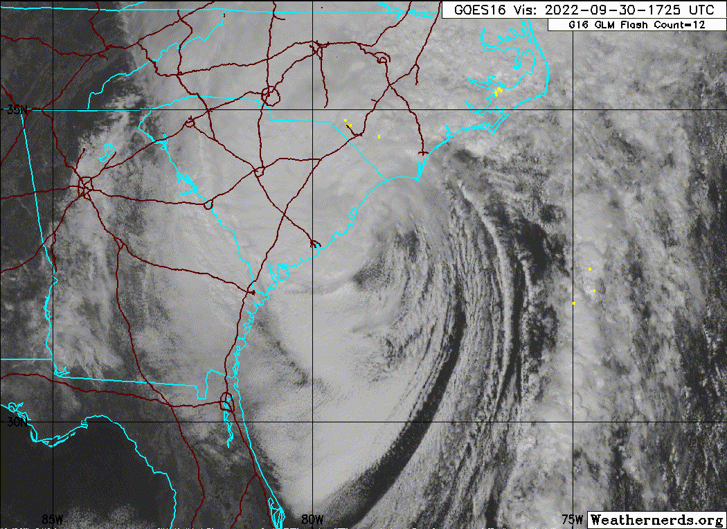
Conway, SC, data suggests center passing just east? They're at 33.8N, 79.0. Note the north wind:
30 Sep 4:15 pm 68 66 94 N 13G24
1.25 Lt Rain OVC006 28.96 981.7 28.99 0.05
30 Sep 3:55 pm 66 64 94 N 21G32
2.00 Hvy Rain OVC008 28.98 982.4 29.01 0.20
And now at 4:45 PM, a WNW wind as the center apparently passes just to its north:
30 Sep 4:35 pm 66 66 100 WNW 9 1.00 Lt Rain OVC004 28.98 982.4 29.01 0.06
Last edited by LarryWx on Fri Sep 30, 2022 3:47 pm, edited 1 time in total.
1 likes
Personal Forecast Disclaimer:
The posts in this forum are NOT official forecasts and should not be used as such. They are just the opinion of the poster and may or may not be backed by sound meteorological data. They are NOT endorsed by any professional institution or storm2k.org. For official information, please refer to the NHC and NWS products.
The posts in this forum are NOT official forecasts and should not be used as such. They are just the opinion of the poster and may or may not be backed by sound meteorological data. They are NOT endorsed by any professional institution or storm2k.org. For official information, please refer to the NHC and NWS products.
-
cycloneye

- Admin

- Posts: 139025
- Age: 67
- Joined: Thu Oct 10, 2002 10:54 am
- Location: San Juan, Puerto Rico
Re: ATL: IAN - Post-Tropical - Discussion
BULLETIN
Post-Tropical Cyclone Ian Advisory Number 33
NWS National Hurricane Center Miami FL AL092022
500 PM EDT Fri Sep 30 2022
...IAN BECOMES POST-TROPICAL BUT THE DANGEROUS STORM SURGE,
FLASH FLOODING AND HIGH WIND THREAT CONTINUES...
SUMMARY OF 500 PM EDT...2100 UTC...INFORMATION
----------------------------------------------
LOCATION...33.9N 79.2W
ABOUT 20 MI...35 KM NW OF MYRTLE BEACH SOUTH CAROLINA
MAXIMUM SUSTAINED WINDS...70 MPH...110 KM/H
PRESENT MOVEMENT...N OR 350 DEGREES AT 15 MPH...24 KM/H
MINIMUM CENTRAL PRESSURE...982 MB...29.00 INCHES
0 likes
Visit the Caribbean-Central America Weather Thread where you can find at first post web cams,radars
and observations from Caribbean basin members Click Here
and observations from Caribbean basin members Click Here
-
hohnywx
- Category 2

- Posts: 504
- Age: 33
- Joined: Sun Jul 19, 2009 8:34 pm
- Location: Hastings-on-Hudson, NY
Re: ATL: IAN - Hurricane - Discussion
Gums wrote:Salute!
We should all be thankful that the NHC/NOAA, Storm2K, et al put out advisories to get out of Dodge early or be prepared for the worst.
Looks like Charleseton and "the Beach" are coming out well, especially compared to Punta Gorda and Ft Myers and......
Last "big one" I recall to hit S.Carolina was Hugo and that was decades ago. We had the first really good satellite coverage and watched the thing come in. At least the folks there had good warning compared to back in the 50's and 60's.
No doubt our weather agencies can do a little bit better, but I cannot say the same for the media. Every storm is different and each one comes to the coast at a different angle and deals with different shoreline topography and such. Then there's the last storm that was 100 years ago and trees, powerlines, etc. are present that had not gone thru the "Darwin" selection process!
So glad that we have minimal loss of life, and it also appears that many new building codes and construction techniques since Andrew have homes/cabins standing after the storm passed.
Gums sends...
They haven’t even begun to announce fatality totals from Lee County. As it is now, there are already 21 deaths. I think your pronouncement here will be mistaken when all is said and done, sadly.
3 likes
-
Old-TimeCane
- Tropical Storm
- Posts: 139
- Age: 43
- Joined: Tue Aug 31, 2004 10:01 pm
- Location: Myrtle Beach, SC
Re: ATL: IAN - Hurricane - Discussion
LarryWx wrote: Conway, SC, data suggests center passing just east? They're at 33.8N, 79.0. Note the north wind:
30 Sep 4:15 pm 68 66 94 N 13G24
1.25 Lt Rain OVC006 28.96 981.7 28.99 0.05
30 Sep 3:55 pm 66 64 94 N 21G32
2.00 Hvy Rain OVC008 28.98 982.4 29.01 0.20
And now at 4:45 PM, a WNW wind as the center apparently passes just to its north:
30 Sep 4:35 pm 66 66 100 WNW 9 1.00 Lt Rain OVC004 28.98 982.4 29.01 0.06
That sounds about right. The center has definitely passed. Pressure is rising rapidly here. It's up to 983.0. Bottomed out at 980.8 from 4:20-4:28. 10 mph wind out right now.
1 likes
The above post is NOT an official forecast and should not be used as such. It is just the opinion of the poster and may or may not be backed by sound meteorological data. It is NOT endorsed by any professional institution or storm2k.org. For official information, please refer to the NHC and NWS products.
-
johngaltfla

- Category 5

- Posts: 1938
- Joined: Sun Jul 10, 2005 9:17 pm
- Location: Sarasota County, FL
- Contact:
Re: ATL: IAN - Post-Tropical - Discussion
I finally have phone data and internet back after 48 hours. I've been to South Venice near Englewood Road and US 41 at Jacaranda in Venice and it is a huge mess. Northport, FL is still flooding as the rain accumulations from the Myakka River plain flow down into the Northport-Port Charlotte area where some localized flooding is north of 8-10 feet still in low lying areas! Numerous power poles snapped in half, one transformer ripped off the pole and tossed across the street, roof damage in many places and lots of 80 year old plus oaks on houses or tearing down power lines. Sarasota is still experiencing flooding in the old celery fields area and some lanes on back roads are impassable unless you have a big 4x4 raised up at least a food.
I'm just now getting the scope beyond what was on the radio about how bad this was and folks, Ian is going to be retired, no ifs, ands or buts. Damned impressive storm even though our top winds (my estimate) were about 90-100 mph off and on for about 6 hours with gusts near 120 mph as the eyewall was just east of us. Add in the rain and it was a huge mess. For those that didn't listen to the NHC about the storm and failed to heed the evacuation warnings, I feel bad for but they were warned. This was one of the most impressive storms I've ever been through and just makes me even more thankful I left Charleston a week before Hugo. Good luck to everyone in the recovery and let's hope that's it for the CONUS this season. One $40 billion storm is enough, thank you very much.
I'm just now getting the scope beyond what was on the radio about how bad this was and folks, Ian is going to be retired, no ifs, ands or buts. Damned impressive storm even though our top winds (my estimate) were about 90-100 mph off and on for about 6 hours with gusts near 120 mph as the eyewall was just east of us. Add in the rain and it was a huge mess. For those that didn't listen to the NHC about the storm and failed to heed the evacuation warnings, I feel bad for but they were warned. This was one of the most impressive storms I've ever been through and just makes me even more thankful I left Charleston a week before Hugo. Good luck to everyone in the recovery and let's hope that's it for the CONUS this season. One $40 billion storm is enough, thank you very much.
4 likes
-
johngaltfla
- Category 5
- Posts: 1938
- Joined: Sun Jul 10, 2005 9:17 pm
- Location: Sarasota County, FL
- Contact:
Re: ATL: IAN - Hurricane - Discussion
Sanibel wrote:Good cell reception at Twins Spring Training ballpark...
A relative saw a flyover of my house...Roof intact and apparently still standing...Hope it didn't wash through in living area above stilts...
Funeral home was prompt and took my mother's body away yesterday at 1pm...4 foor surge had lapped at building first floor where she died...Person also died of heart attack there in car...
Got word from Sun Dial Resort 20 foot surge washed through second storie there...
Damn old friend, I'm so sorry to hear about your mom.
Good luck on your home and I am glad to see you are ok.
0 likes
-
Sciencerocks
- Category 5
- Posts: 7282
- Age: 38
- Joined: Thu Jul 06, 2017 1:51 am
Re: ATL: IAN - Hurricane - Discussion
Gums wrote:Salute!
We should all be thankful that the NHC/NOAA, Storm2K, et al put out advisories to get out of Dodge early or be prepared for the worst.
Looks like Charleseton and "the Beach" are coming out well, especially compared to Punta Gorda and Ft Myers and......
Last "big one" I recall to hit S.Carolina was Hugo and that was decades ago. We had the first really good satellite coverage and watched the thing come in. At least the folks there had good warning compared to back in the 50's and 60's.
No doubt our weather agencies can do a little bit better, but I cannot say the same for the media. Every storm is different and each one comes to the coast at a different angle and deals with different shoreline topography and such. Then there's the last storm that was 100 years ago and trees, powerlines, etc. are present that had not gone thru the "Darwin" selection process!
So glad that we have minimal loss of life, and it also appears that many new building codes and construction techniques since Andrew have homes/cabins standing after the storm passed.
Gums sends...
I saw a tweet that said this was the third highest storm surge at wherever (I think Myrtle Beach area) (at least in the recent era) after Hugo and Matthew.
3 likes
-
setxsunshine
- Tropical Low

- Posts: 37
- Joined: Fri Jul 23, 2010 10:26 am
- Location: SE Texas
Re: ATL: IAN - Hurricane - Discussion
karenfromheaven wrote:Nuno wrote:wxman57 wrote:
Agree that the cone is absolutely meaningless as far as indicating a threat or possible impacts. The general accuracy of forecasts over the past 5 seasons (current cone) likely bears no resemblance to current uncertainty or possible impacts. In this case, the cone did not include Lee County because landfall uncertainty here was higher than the 5 season average. Cone never changes, though. It's always the same for every advisory with every storm, all season long.
What's needed is a probabilistic cone based on current storm wind field size and ensemble data. Trouble with that is the ensemble data for 8am EDT, for example, isn't all available until around 5pm EDT. Takes too long to get the ensemble data from the European run after the deterministic run is in. Forecasts were good. Hurricane into the coast near Ft. Myers from 24 hours out. Just minor heading changes were the difference between Tampa and Ft. Myers, same as with Charley.
Forecasts would have been shifted southward to Ft. Myers more quickly if the GFS had not been pulling the consensus model well northward across the peninsula. We ignored the GFS and compensated by adjusting the track farther south than the NHC. In the heat of battle, so to speak, it's hard to identify what model to trust. I knew that the GFS would be too slow and too far west, as it always is with a westerly sheared storm in the Gulf. But how much farther east/south would it track? That's the hard part.
But even amateurs here were insistent that GFS was out to lunch, what mechanism prevented the NHC from adding less weight to the GFS and its ensembles leading up to landfall? You could ignore the GFS in your professional setting, why couldn't the NHC? Is this also why watches were so delayed?
It does seem in recent years the NHC is far more cautious in issuing watches all around. I noticed many times in SEFL that we get TS watches for what would've been a hurricane watch in the past. Great, we have better forecasting capabilities now, but when it comes time to actually pull the trigger for a watch (and also for PTC's as I have noticed) it comes off as somewhat arbitrary when matched up to potential impacts? Like at what point does the NHC issue a TS watch, when the probability exceeds >40%? >75%? I am genuinely curious as I do not know this aspect of how the NHC operates.
Local officials and forecasters here were under pressure because they gave surge warnings and evacuations for Irma, and correctly so, which did not come to pass when Irma deviated east at the last minute from the forecast track. But local stations here for Ian were great and warned over and over for people to get out while there was still time. And there was time! I'm sorry, but this is on those who did not leave. Yes, I'm a little frustrated. My house was just outside the cone of Ian, but when it came ashore, the wind field expanded and the outer eyewall spend hours over my house, tearing out my pool screens and ripping shingles off my roof. But I expected this possibility, I was prepared, and the house is on high ground outside of evac zones. People down here are very conservative. They believe in their "personal freedom", didn't wear masks during covid, and sadly some thought they knew better than anyone else what they should do during this storm. The Lee County sheriff announced on TV many times before the storm that they would not, and could not, put their officers at risk once winds exceeded 45 mph, and he flatly said they would not respond to 911 calls during the storm. This is not an NHC problem. This is a problem with people who live here. It's just a shame that they are now taking resources away from recovery, and putting first responders' lives at risk in the process.
The same thing happens in every storm whether the people are conservative or not. Local officials always inform people there will not be rescues during the storm. For whatever reason, some stay. Some reasons may actually be legit, but, ultimately, it's up to the individual. And first responders will do what they do and rescue people. My son is a first responder, so I get it.
Frustrations are high right now. It has been an awful few days and it's just beginning as far as getting things back to some sort of normalcy. Lot's of heartache and hard work ahead. I pray things go as smoothly as possible for all involved.
4 likes

Re: ATL: IAN - Hurricane - Discussion
typhoonty wrote:I'm willing to bet Lee County has the most population of any county in the United States actually located in a surge evacuation zone, although I haven't done the calculations. I'd estimate 95% of Lee County population is in a surge zone from a 5.
100% of Monroe County, Fl(the Keys) is in a surge zone from a 4..but thats only about 85,000 residents.
1 likes
Re: ATL: IAN - Hurricane - Discussion
setxsunshine wrote:The same thing happens in every storm whether the people are conservative or not. Local officials always inform people there will not be rescues during the storm. For whatever reason, some stay. Some reasons may actually be legit, but, ultimately, it's up to the individual. And first responders will do what they do and rescue people. .
With Ian many live aboard boaters in Key West stayed on their boats in the anchorage(offshore and exposed) during Ian. While many did this expecting "only tropical storm conditions", some would have done it with a hurricane warning as well.
There was no mandatory evacuation in effect for live aboard boaters like there was for past storms. This also played a role for the decision of many.
Needless to say there were Mayday calls Tuesday night. One couple I know of and their boat I is still missing. Some believe they saw their boat capsized and drifting out to sea(or Gulf) during the storm .
Obviously the Coast Guard could not put their seaman at risk during the height of the storm with Beaufort 10+ conditions to answer those calls until the winds subsided.
There are a lot of lessons to be learned from Ian.
2 likes
Re: ATL: IAN - Hurricane - Discussion
MetsIslesNoles wrote:Listening to FEMA / Governor's press conference in Lee county right now, and I have to agree with the posters that have said we need something different than the cone in the future.
Despite every meteorologist worth his degree warning against not focusing on the cone, the lay person does not get that message.
Perhaps wind speed probabilities and/or timing of winds need to be overlayed on the cone. That way those outside the cone can see visually they will be impacted.
5 likes

Re: ATL: IAN - Post-Tropical - Discussion
I went to South Daytona/Port Orange area this morning because of work, I think that reanalysis is going to show that Ian was a hurricane again way sooner than when the recon got there later in the evening.
The damage that I saw is not of a TS, the wind damage that I see on TV on structures right on the Beach is definitely of a hurricane. The Beach Safety Headquarter Station right on the beach reported sustained hurricane force winds with wind gusts in the 90s, but not sure the height of the anemometer.
The damage that I saw is not of a TS, the wind damage that I see on TV on structures right on the Beach is definitely of a hurricane. The Beach Safety Headquarter Station right on the beach reported sustained hurricane force winds with wind gusts in the 90s, but not sure the height of the anemometer.
5 likes
Who is online
Users browsing this forum: No registered users and 21 guests