
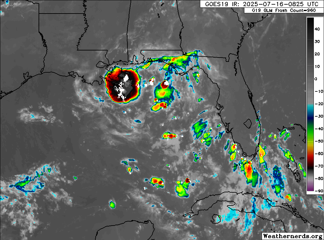
Convection is mainly driven by some shear with a 4000 CAPE infeed.
Anticyclone is to the east of the convection.
Good equator-ward outflow.
Watching closely.
ATL: INVEST 93L - Discussion
Moderators: hurricanetrack, S2k Moderators

The posts in this forum are NOT official forecasts and should not be used as such. They are just the opinion of the poster and may or may not be backed by sound meteorological data. They are NOT endorsed by any professional institution or STORM2K. For official information, please refer to products from the National Hurricane Center and National Weather Service.

Re: ATL: INVEST 93L - Discussion
0 likes
-
Hypercane_Kyle

- Category 5

- Posts: 3352
- Joined: Sat Mar 07, 2015 7:58 pm
- Location: Cape Canaveral, FL
Re: ATL: INVEST 93L - Discussion
My guess is this one will spin up right as it reaches the Louisiana coastline. HAFS-A portrays a realistic scenario.
0 likes
My posts are my own personal opinion, defer to the National Hurricane Center (NHC) and other NOAA products for decision making during hurricane season.
-
cycloneye

- Admin

- Posts: 145274
- Age: 68
- Joined: Thu Oct 10, 2002 10:54 am
- Location: San Juan, Puerto Rico
Re: ATL: INVEST 93L - Discussion
0 likes
Visit the Caribbean-Central America Weather Thread where you can find at first post web cams,radars
and observations from Caribbean basin members Click Here
and observations from Caribbean basin members Click Here
-
wxman57

- Moderator-Pro Met

- Posts: 22977
- Age: 67
- Joined: Sat Jun 21, 2003 8:06 pm
- Location: Houston, TX (southwest)
Re: ATL: INVEST 93L - Discussion
MLC has moved rapidly west to south of the western FL Panhandle. That's where all the convection is concentrated, and that's where to look for any LLC. That convection will be moving inland early tomorrow, so development chances have dropped way down. Looking like only 3-5" of rain across south LA and southern MS. Next!
0 likes
-
cycloneye
- Admin
- Posts: 145274
- Age: 68
- Joined: Thu Oct 10, 2002 10:54 am
- Location: San Juan, Puerto Rico
Re: ATL: INVEST 93L - Discussion
Tropical Weather Outlook
NWS National Hurricane Center Miami FL
800 AM EDT Wed Jul 16 2025
For the North Atlantic...Caribbean Sea and the Gulf of America:
Northeastern and north-central Gulf (AL93):
Surface and radar observations indicate that a broad area of low
pressure is moving westward across the Florida Panhandle between
Tallahassee and Panama City. The associated shower and thunderstorm
activity is disorganized and located mainly south and southwest of
the center. This system is forecast to continue moving westward, and
could emerge or redevelop over the far northeastern to north-central
portion of the Gulf later today or tonight, reaching the coast of
Louisiana by Thursday. If this system moves far enough offshore,
environmental conditions over the Gulf appear generally favorable
for additional development, and a tropical depression could still
form over the next couple of days before the system moves fully
inland by the end of the week.
Regardless of development, heavy rainfall could produce localized
flash flooding over portions of Florida through through today.
Heavy rainfall could also cause flash flooding for portions of the
north-central Gulf Coast beginning late today and continuing through
Friday. For additional information, please refer to products issued
by the Weather Prediction Center and your local National Weather
Service office.
* Formation chance through 48 hours...medium...40 percent.
* Formation chance through 7 days...medium...40 percent.
$$
Forecaster Beven
0 likes
Visit the Caribbean-Central America Weather Thread where you can find at first post web cams,radars
and observations from Caribbean basin members Click Here
and observations from Caribbean basin members Click Here
Re: ATL: INVEST 93L - Discussion
Doesn't look like much will happen today with it, maybe as it gets closer to Louisiana. All the models keeping it in the general area and looping it back into the gulf in a week or so are wild though. And that keys thing is still there.
1 likes
Re: ATL: INVEST 93L - Discussion
I now think that the prior 40% chance for TCG from 93L is now down to closer to 20%. But about everything has become a TC so far this season. So, we’ll see.
1 likes
Personal Forecast Disclaimer:
The posts in this forum are NOT official forecasts and should not be used as such. They are just the opinion of the poster and may or may not be backed by sound meteorological data. They are NOT endorsed by any professional institution or storm2k.org. For official information, please refer to the NHC and NWS products.
The posts in this forum are NOT official forecasts and should not be used as such. They are just the opinion of the poster and may or may not be backed by sound meteorological data. They are NOT endorsed by any professional institution or storm2k.org. For official information, please refer to the NHC and NWS products.
-
cycloneye
- Admin
- Posts: 145274
- Age: 68
- Joined: Thu Oct 10, 2002 10:54 am
- Location: San Juan, Puerto Rico
Re: ATL: INVEST 93L - Discussion
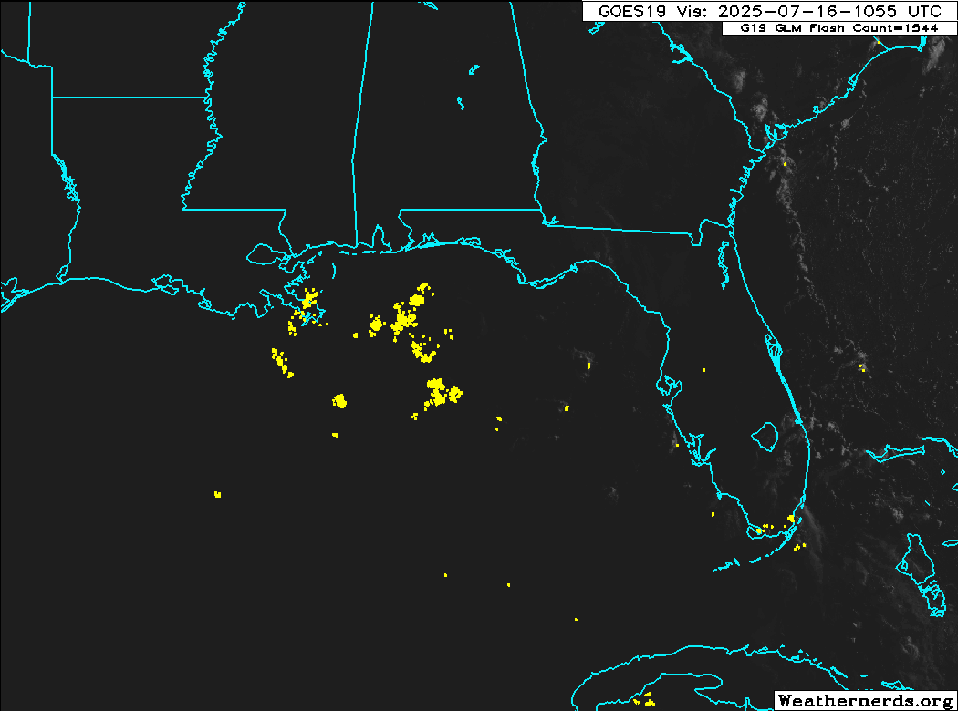
The low pressure is inland in the Panhandle per 12z best track.

AL, 93, 2025071612, , BEST, 0, 303N, 849W, 25, 1012, DB
3 likes
Visit the Caribbean-Central America Weather Thread where you can find at first post web cams,radars
and observations from Caribbean basin members Click Here
and observations from Caribbean basin members Click Here
-
tropicwatch

- Category 5
- Posts: 3383
- Age: 61
- Joined: Sat Jun 02, 2007 10:01 am
- Location: Panama City Florida
- Contact:
Re: ATL: INVEST 93L - Discussion
cycloneye wrote:The low pressure is inland in the Panhandle per 12z best track.AL, 93, 2025071612, , BEST, 0, 303N, 849W, 25, 1012, DB
https://i.imgur.com/yKuLegH.png
Possibly elongated stretching out south of Panama City.
https://earth.nullschool.net/#current/wind/surface/level/orthographic=-85.50,28.02,2184
Last edited by tropicwatch on Wed Jul 16, 2025 9:18 am, edited 1 time in total.
0 likes
Tropicwatch
Agnes 72', Eloise 75, Elena 85', Kate 85', Charley 86', Florence 88', Beryl 94', Dean 95', Erin 95', Opal 95', Earl 98', Georges 98', Ivan 2004', Arlene 2005', Dennis 2005', Ida 2009' Debby 2012' Irma 2017' Michael 2018'
Agnes 72', Eloise 75, Elena 85', Kate 85', Charley 86', Florence 88', Beryl 94', Dean 95', Erin 95', Opal 95', Earl 98', Georges 98', Ivan 2004', Arlene 2005', Dennis 2005', Ida 2009' Debby 2012' Irma 2017' Michael 2018'
-
MGC

- S2K Supporter

- Posts: 5897
- Joined: Sun Mar 23, 2003 9:05 pm
- Location: Pass Christian MS, or what is left.
Re: ATL: INVEST 93L - Discussion
Low is still moving inland and should decay away today. Chance that a new surface low might develop near the MLC. Still a lot of shear over the Gulf. Something to keep an eye on. Good thing the surface low went inland yesterday......MGC
1 likes
Re: ATL: INVEST 93L - Discussion
First decent visible loop highlights the area around PCB (close to best track) and the MLC south of Mobile (with lightning to match). Very detached right now. This and the main blob is going to be over Louisiana later today at this rate.
1 likes
-
Tailgater33
- Tropical Depression

- Posts: 87
- Joined: Thu Jun 02, 2022 9:15 am
Re: ATL: INVEST 93L - Discussion
The area south of PCB is the area to watch IMO. Watching the radar closely and earth link
1 likes
-
Stormlover70
- Tropical Storm

- Posts: 175
- Age: 55
- Joined: Fri Jun 21, 2024 5:31 am
- Location: New port richey
Re: ATL: INVEST 93L - Discussion
Like wxman57 said. Next. No big deal. 5 inches of rain no wind. Polk County here in florida got 11.47 inches the other night.
0 likes
-
Hurricaneman

- Category 5
- Posts: 7351
- Age: 45
- Joined: Tue Aug 31, 2004 3:24 pm
- Location: central florida
Re: ATL: INVEST 93L - Discussion
My feeling is we have to wait until August for the next one, this one will most likely not reform offshore
1 likes
Re: ATL: INVEST 93L - Discussion

Hurricaneman wrote:My feeling is we have to wait until August for the next one, this one will most likely not reform offshore
I think this thread is on life support and the plug is almost pulled
0 likes
Harvey,Hanna,Beta,Texas Winter storm2021,Nicholas,Beryl
Re: ATL: INVEST 93L - Discussion
Well I am moving from Houston to Lafayette the end of the month so I image my future is bright for tracking storms
0 likes
Harvey,Hanna,Beta,Texas Winter storm2021,Nicholas,Beryl
-
jaguars_22
- Category 2

- Posts: 588
- Joined: Tue Jun 20, 2017 2:26 pm
- Location: Victoria TX
Re: ATL: INVEST 93L - Discussion
This almost looks like a gyre system we would get down into Central America?? Huge swirl of spin rotating around each other... The one by the keys looks to still have it.. the one on land florida panhandle... another one south of pensacola
0 likes
Return to “Active Storms/Invests - Atlantic/EastPAC/CentralPAC/MED”
Who is online
Users browsing this forum: Google Adsense [Bot] and 20 guests