ATL: ERIN - Models

Moderator: S2k Moderators

Message
Author
User avatar
WaveBreaking
Category 2
Category 2
Posts: 602
Joined: Sun Jun 30, 2024 11:33 am
Location: US

Re: ATL: ERIN - Models

#361 Postby WaveBreaking » Wed Aug 13, 2025 4:17 pm

Kingarabian wrote:18z ICON coming in more SW compared to the past 4 runs through hour 84. Sitting just north of PR.


Looks like the ICON has a narrow 591dm ridge forming just N of Erin. Other models have this ridge either weaker or nonexistent.

Image
0 likes   
I am NOT a professional meteorologist, so take all of my posts with a grain of salt. My opinions are mine and mine alone.

User avatar
kevin
Category 5
Category 5
Posts: 2658
Age: 26
Joined: Wed Aug 28, 2019 4:35 am

Re: ATL: ERIN - Models

#362 Postby kevin » Wed Aug 13, 2025 4:23 pm

Big shift west for the 18z ICON. The 18z run ends at +120hr at 24.0N/71.7W, almost 2.5 deg WSW of its 12z run (24.5N/69.3W). It's also quite far west compared to the 12z Euro (23.8N/69.7W at +126hr) and would make a US landfall possible.

Image
1 likes   

floridasun
Tropical Storm
Tropical Storm
Posts: 218
Joined: Tue Sep 14, 2021 3:59 pm

Re: ATL: ERIN - Models

#363 Postby floridasun » Wed Aug 13, 2025 4:25 pm

so all timing with high weaking as some models saying it fight models who right it will turn but question where
0 likes   

LarryWx
S2K Supporter
S2K Supporter
Posts: 6512
Joined: Sun Sep 07, 2003 2:04 pm
Location: GA

Re: ATL: ERIN - Models

#364 Postby LarryWx » Wed Aug 13, 2025 4:28 pm

12Z JMA again recurves at 70W. Two days ago it hit Bermuda directly.
0 likes   
Personal Forecast Disclaimer:
The posts in this forum are NOT official forecasts and should not be used as such. They are just the opinion of the poster and may or may not be backed by sound meteorological data. They are NOT endorsed by any professional institution or storm2k.org. For official information, please refer to the NHC and NWS products.

User avatar
Hypercane_Kyle
Category 5
Category 5
Posts: 3383
Joined: Sat Mar 07, 2015 7:58 pm
Location: Cape Canaveral, FL

Re: ATL: ERIN - Models

#365 Postby Hypercane_Kyle » Wed Aug 13, 2025 4:45 pm

12z Euro gets close enough to US coast to actually bring tangible impacts beyond surf.
1 likes   
My posts are my own personal opinion, defer to the National Hurricane Center (NHC) and other NOAA products for decision making during hurricane season.

User avatar
Kingarabian
S2K Supporter
S2K Supporter
Posts: 16109
Joined: Sat Aug 08, 2009 3:06 am
Location: Honolulu, Hawaii

Re: ATL: ERIN - Models

#366 Postby Kingarabian » Wed Aug 13, 2025 4:59 pm

18z GFS looking like a safe for the CONUS so far.
0 likes   
RIP Kobe Bryant

User avatar
kevin
Category 5
Category 5
Posts: 2658
Age: 26
Joined: Wed Aug 28, 2019 4:35 am

Re: ATL: ERIN - Models

#367 Postby kevin » Wed Aug 13, 2025 5:01 pm

18z looks like it'll recurve (still running, +97hr now), but it is still about 1.4 degrees west of the 12z GFS run. Of course still clearly east of the latest Euro and ICON runs.
0 likes   

User avatar
ronjon
Category 5
Category 5
Posts: 4840
Joined: Fri Aug 19, 2005 5:17 pm
Location: Hernando Beach, FL

Re: ATL: ERIN - Models

#368 Postby ronjon » Wed Aug 13, 2025 5:08 pm

Both 12z and 18z ICON keep fairly strong riding (592 dm) at the mid-level extending from the SW Atlantic bridging west into the SE US. This pattern prevents a quick escape poleward by Erin into the open Atlantic. It builds even stronger ridging to the NE of Erin through 180 hrs at 594 dm. We'll have to see if this trend continues and is picked up by other models. Still looking at 5-7 days out so Upper level pattern isn't set in stone yet.
3 likes   

DunedinDave
Category 1
Category 1
Posts: 255
Joined: Fri Aug 25, 2023 10:31 am

Re: ATL: ERIN - Models

#369 Postby DunedinDave » Wed Aug 13, 2025 5:36 pm

That ICON run gets dangerously close to Hispaniola/DR. The question I have for the experts on here is if it did hit those mountains and it crushes the circulation, would that weaken it to the point of preventing a more northerly turn since weaker storms tend to want to more more west.
4 likes   

AutoPenalti
Category 5
Category 5
Posts: 4060
Age: 29
Joined: Mon Aug 17, 2015 4:16 pm
Location: Ft. Lauderdale, Florida

Re: ATL: ERIN - Models

#370 Postby AutoPenalti » Wed Aug 13, 2025 5:56 pm

No matter how far left this goes, the weakness is still there for it move away from the SFL.
2 likes   
The posts in this forum are NOT official forecasts and should not be used as such. They are just the opinion of the poster and may or may not be backed by sound meteorological data. They are NOT endorsed by any professional institution or STORM2K. For official information, please refer to products from the NHC and NWS.


Model Runs Cheat Sheet:
GFS (5:30 AM/PM, 11:30 AM/PM)
HWRF, GFDL, UKMET, NAVGEM (6:30-8:00 AM/PM, 12:30-2:00 AM/PM)
ECMWF (1:45 AM/PM)

TCVN
is a weighted averaged

redingtonbeach
Tropical Depression
Tropical Depression
Posts: 61
Joined: Mon Sep 04, 2017 12:05 am

Re: ATL: ERIN - Models

#371 Postby redingtonbeach » Wed Aug 13, 2025 6:04 pm

redingtonbeach wrote:
cycloneye wrote:The 00z run of the spaghetti's for track and intensity.


Hmmmm..

"The HAFS is NOAA’s next-generation multi-scale numerical mode..."

Hmmmm..

Sure looks to me like HAFS are still heading west...??

Hmmmm..


Hmmm.. so HAFS was the only model to correctly identify the continued westerly track. Interesting.
0 likes   

User avatar
Hypercane_Kyle
Category 5
Category 5
Posts: 3383
Joined: Sat Mar 07, 2015 7:58 pm
Location: Cape Canaveral, FL

Re: ATL: ERIN - Models

#372 Postby Hypercane_Kyle » Wed Aug 13, 2025 6:24 pm

HAFS-A coming in nearly a full degree south.
0 likes   
My posts are my own personal opinion, defer to the National Hurricane Center (NHC) and other NOAA products for decision making during hurricane season.

User avatar
Nimbus
Category 5
Category 5
Posts: 5358
Joined: Mon Jul 19, 2004 10:54 am

Re: ATL: ERIN - Models

#373 Postby Nimbus » Wed Aug 13, 2025 6:32 pm

WaveBreaking wrote:
Kingarabian wrote:18z ICON coming in more SW compared to the past 4 runs through hour 84. Sitting just north of PR.


Looks like the ICON has a narrow 591dm ridge forming just N of Erin. Other models have this ridge either weaker or nonexistent.

Image


Hope this isn't a trend the ridge is steadily building in to the north the last 12 hours.

Image
3 likes   

AxaltaRacing24
Category 5
Category 5
Posts: 1766
Age: 25
Joined: Wed Jul 27, 2016 11:14 am
Location: Jupiter, FL

Re: ATL: ERIN - Models

#374 Postby AxaltaRacing24 » Wed Aug 13, 2025 6:44 pm

Nimbus wrote:
WaveBreaking wrote:
Kingarabian wrote:18z ICON coming in more SW compared to the past 4 runs through hour 84. Sitting just north of PR.


Looks like the ICON has a narrow 591dm ridge forming just N of Erin. Other models have this ridge either weaker or nonexistent.

https://i.imgur.com/CaaWyEN.png


Hope this isn't a trend the ridge is steadily building in to the north the last 12 hours.

https://i.imgur.com/Hg8WQmU.jpeg

Although this is highly, and i mean HIGHLY unlikely, it only takes 2 or 3 more shifts like that to put people back into play. Some ensembles still slow that southern solutions are not 110% impossible.
1 likes   

User avatar
cycloneye
Admin
Admin
Posts: 146364
Age: 69
Joined: Thu Oct 10, 2002 10:54 am
Location: San Juan, Puerto Rico

Re: ATL: ERIN - Models

#375 Postby cycloneye » Wed Aug 13, 2025 6:48 pm

0 likes   
Visit the Caribbean-Central America Weather Thread where you can find at first post web cams,radars
and observations from Caribbean basin members Click Here

User avatar
aspen
Category 5
Category 5
Posts: 8865
Joined: Sat Oct 12, 2019 7:10 pm
Location: Connecticut, USA

Re: ATL: ERIN - Models

#376 Postby aspen » Wed Aug 13, 2025 6:49 pm

The consensus from the last few hurricane model runs seems to be that Erin will take another 24 hours to fully recover and consolidate, followed by a RI phase on Friday that gets halted by shear on Saturday. Shear then seems to let up by the end of the weekend, allowing for it to maintain MH status.

Also the 18z HWRF had a garbage initialization (looks more like it did yesterday afternoon on that run) and should probably be ignored.
0 likes   
Irene '11 Sandy '12 Hermine '16 5/15/2018 Derecho Fay '20 Isaias '20 Elsa '21 Henri '21 Ida '21

I am only a meteorology enthusiast who knows a decent amount about tropical cyclones. Look to the professional mets, the NHC, or your local weather office for the best information.

User avatar
Kingarabian
S2K Supporter
S2K Supporter
Posts: 16109
Joined: Sat Aug 08, 2009 3:06 am
Location: Honolulu, Hawaii

Re: ATL: ERIN - Models

#377 Postby Kingarabian » Wed Aug 13, 2025 6:52 pm

Nimbus wrote:
WaveBreaking wrote:
Kingarabian wrote:18z ICON coming in more SW compared to the past 4 runs through hour 84. Sitting just north of PR.


Looks like the ICON has a narrow 591dm ridge forming just N of Erin. Other models have this ridge either weaker or nonexistent.

https://i.imgur.com/CaaWyEN.png


Hope this isn't a trend the ridge is steadily building in to the north the last 12 hours.

https://i.imgur.com/Hg8WQmU.jpeg


Erin's position over the next 24 hours will also play a role down the line. A track more south than forecast in the near term may delay the NW turn.
0 likes   
RIP Kobe Bryant

User avatar
Kingarabian
S2K Supporter
S2K Supporter
Posts: 16109
Joined: Sat Aug 08, 2009 3:06 am
Location: Honolulu, Hawaii

Re: ATL: ERIN - Models

#378 Postby Kingarabian » Wed Aug 13, 2025 7:03 pm

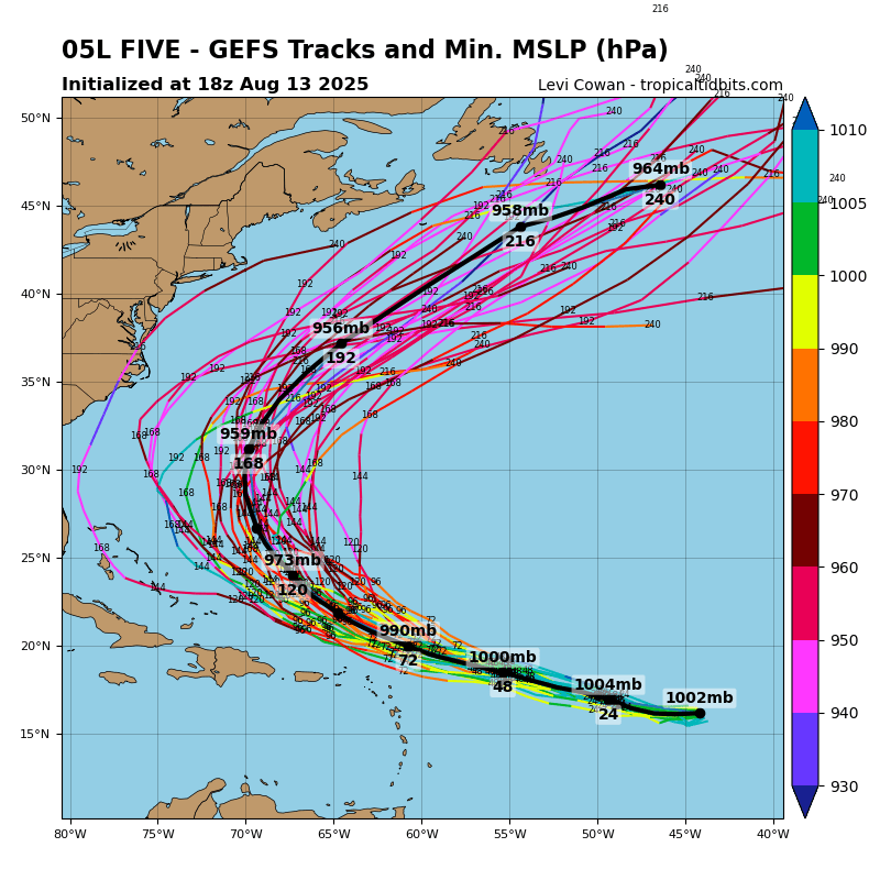
18z GEFS has more members west compared to the past 3 runs. Majority show a clean recurve or a Bermuda impact.

Image
0 likes   
RIP Kobe Bryant

BobHarlem
Category 5
Category 5
Posts: 2362
Joined: Thu Oct 20, 2005 6:11 pm

Re: ATL: ERIN - Models

#379 Postby BobHarlem » Wed Aug 13, 2025 7:09 pm

18z HAFS A & B are left of the 12z some. (b 22.7N now vs 23.2N at 12z, a 22.0N vs 23.0N at 12z ) -- using frame at 18z monday the 18th.
final frames below - Turks and Caicos are the islands on the left, and southeast bahamas visible on the A:
Image

Image
1 likes   

User avatar
Kingarabian
S2K Supporter
S2K Supporter
Posts: 16109
Joined: Sat Aug 08, 2009 3:06 am
Location: Honolulu, Hawaii

Re: ATL: ERIN - Models

#380 Postby Kingarabian » Wed Aug 13, 2025 7:35 pm

18z Euro is a bit more SW at hour 72 compared to the 12z run.
1 likes   
RIP Kobe Bryant


Return to “2025”

Who is online

Users browsing this forum: No registered users and 37 guests