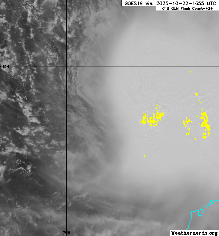
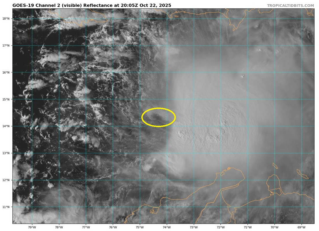
NATL: MELISSA - Tropical Storm - Discussion

Current storms and invests:

Moderators: hurricanetrack, S2k Moderators


The posts in this forum are NOT official forecasts and should not be used as such. They are just the opinion of the poster and may or may not be backed by sound meteorological data. They are NOT endorsed by any professional institution or STORM2K. For official information, please refer to products from the National Hurricane Center and National Weather Service.

Help Support Storm2K
Message
Author
User avatar
Weatherboy1
Category 5
Category 5
Posts: 1190
Age: 49
Joined: Mon Jul 05, 2004 1:50 pm
Location: Jupiter/Sarasota, FL

Re: NATL: MELISSA - Tropical Storm - Discussion

#261 Postby Weatherboy1 » Wed Oct 22, 2025 3:28 pm

CrazyC83 wrote:
Zonacane wrote:Melissa is going to be weak and disorganized for a couple days, Melissa is still going to be a record breaking storm.


And that is why the models go nuts. If Melissa strengthened to, say category 1 or 2, now in spite of the shear, it would be Hispaniola bound. But instead it's so weak that the first front isn't a factor at all. Hence the current westward movement.

There's little to suggest strengthening in the short term. It's the middle and long term where the questions lie...


Agreed. And that's why while I seriously DOUBT Melissa will have any impact in South Florida, I'm not 100% ruling it out. Models have mostly swung to the "move west for a while before turning NW/N/NE" camp. They almost all say that turn will happen early enough to be a Jamaica/Cuba/Bahamas/Haiti issue. But could that change as downstream conditions do, especially if the westward movement persists for some time? Maybe.
Last edited by Weatherboy1 on Wed Oct 22, 2025 3:29 pm, edited 1 time in total.
1 likes   

User avatar
Blown Away
S2K Supporter
S2K Supporter
Posts: 10217
Joined: Wed May 26, 2004 6:17 am

Re: NATL: MELISSA - Tropical Storm - Discussion

#262 Postby Blown Away » Wed Oct 22, 2025 3:29 pm

Image

Image

Melissa's LLC popping out to the west of the convection. My estimate @14.3N/74.3W, moving West @5mph... :lol:
4 likes   
Hurricane Eye Experience: David 79, Irene 99, Frances 04, Jeanne 04, Wilma 05… Hurricane Brush Experience: Andrew 92, Erin 95, Floyd 99, Matthew 16, Irma 17, Ian 22, Nicole 22…

User avatar
zal0phus
Tropical Storm
Tropical Storm
Posts: 194
Age: 24
Joined: Mon Jan 07, 2019 8:32 am
Location: St. Louis
Contact:

Re: NATL: MELISSA - Tropical Storm - Discussion

#263 Postby zal0phus » Wed Oct 22, 2025 3:37 pm

storm_in_a_teacup wrote:
LarryWx wrote:
chaser1 wrote:
To be fair though, there is a major distinction between those with a primarily analytical yet sterile appreciation of meteorological data, graphics, records, and numbers.... and those who quite honestly were turned-on to "severe weather" as a result of seeing or experiencing the ferocious awe of Mother Nature. One cannot be awed by the extreme impact of a hurricane unless one has a frame of reference depicting storm surge and it's effects or the manner in which a major hurricane winds humble ourselves and mankind's mighty construction or technology. Tornado's are potentially a bit different in that one can appreciate a wide angle view of the sky along with the menacing vortex dropping from the sky, potentially over open space with no construction or people around.

Let's be fair though. Most people (myself included) ARE mesmerized when incredible chaser or witness video depicting the manner in which severe weather impacts our world comes forward. I also think that most if not all of us equally cringe at the same time, when witnessing the horribly sad and depressing impact to others where visible. I have zero interest in witnessing a drowning, severe injury occur, or a person whisked away by severe wind.

In the end, it is largely our viewing the world around us which shapes our understanding, appreciation, interest, AND risk mitigation as we move forward.


Hey Chaser,
For specific examples of what I’m referring to, please go to the link below, if interested, and reply to that there if you’d like to (if you don’t mind). Keep in mind that I’ve followed these 5 folks’ posts for awhile in addition to other posters with similar desires. So, I’m quite familiar with their repeatedly honestly stated desires regarding hurricanes:

https://www.storm2k.org/phpbb2/viewtopi ... 0#p3142975


Oh no please don’t start the dreaded r/tropicalweather “how much hurricane enthusiasm is too much???” fight again.

(Also, never post storm personifications on Reddit)


The tornado subreddit had this exact same problem earlier this year on a huge scale. It seems endemic to any kind of severe weather community and it's very tiresome. On one hand you have those blatantly begging for extreme disasters, and on the other you have those who think any interest at all in severe weather is some horrible sin. That begs the question of why they're there though (doesn't apply to hurricanes as there's value in predicting them--but not really for tornadoes).
5 likes   
Do not take anything I say seriously as a form of meteorological prediction. I am not a meteorologist; I don't think being in law school translates to any special knowledge. I am just a somewhat bullish amateur watcher.

User avatar
aspen
Category 5
Category 5
Posts: 8930
Joined: Sat Oct 12, 2019 7:10 pm
Location: Connecticut, USA

Re: NATL: MELISSA - Tropical Storm - Discussion

#264 Postby aspen » Wed Oct 22, 2025 3:44 pm

5pm cone now calls for a Cat 4 at the end of the forecast period.
3 likes   
Irene '11 Sandy '12 Hermine '16 5/15/2018 Derecho Fay '20 Isaias '20 Elsa '21 Henri '21 Ida '21

I am only a meteorology enthusiast who knows a decent amount about tropical cyclones. Look to the professional mets, the NHC, or your local weather office for the best information.

User avatar
cycloneye
Admin
Admin
Posts: 147921
Age: 69
Joined: Thu Oct 10, 2002 10:54 am
Location: San Juan, Puerto Rico

Re: NATL: MELISSA - Tropical Storm - Discussion

#265 Postby cycloneye » Wed Oct 22, 2025 3:50 pm

The sad part of all of what will transpire in the next few days is well ilustrated by Papín in the 5 PM discussion.

Unfortunately, it is becoming increasingly likely that Melissa will become a large and
dangerous hurricane by the end of the forecast period.
5 likes   
Visit the Caribbean-Central America Weather Thread where you can find at first post web cams,radars
and observations from Caribbean basin members Click Here

User avatar
Teban54
Category 5
Category 5
Posts: 3546
Joined: Sat May 19, 2018 1:19 pm

Re: NATL: MELISSA - Tropical Storm - Discussion

#266 Postby Teban54 » Wed Oct 22, 2025 4:10 pm

cycloneye wrote:The sad part of all of what will transpire in the next few days is well ilustrated by Papín in the 5 PM discussion.

Unfortunately, it is becoming increasingly likely that Melissa will become a large and
dangerous hurricane by the end of the forecast period.

The sentence just before:
This forecast is in the best agreement with the HCCA intensity aid, but it is worth noting it's under the latest HAFS-A/B and HMON forecasts.
2 likes   

User avatar
Teban54
Category 5
Category 5
Posts: 3546
Joined: Sat May 19, 2018 1:19 pm

Re: NATL: MELISSA - Tropical Storm - Discussion

#267 Postby Teban54 » Wed Oct 22, 2025 4:13 pm

Also worth noting that according to NHC/Papin, Melissa already had a center reformation last night -- which still didn't result in any further intensification today that models like GFS were calling for. Even if yet another relocation happens, my guess is that it won't improve Melissa's structure until the shear finally lets up.
The current vortex misalignment of Melissa is a significant impediment to short-term intensification, and the vertical wind shear is expected to maintain this tilted structure over the next 24-36 hours, although I can't preclude any center reformations down-shear, like what occurred last night. After this period, the ECWMF-SHIPS guidance now indicates the ongoing westerly shear will decrease to 10-15 knots, and the storm remains over very warm sea-surface temperatures and high oceanic heat content.
2 likes   

User avatar
cycloneye
Admin
Admin
Posts: 147921
Age: 69
Joined: Thu Oct 10, 2002 10:54 am
Location: San Juan, Puerto Rico

Re: NATL: MELISSA - Tropical Storm - Discussion

#268 Postby cycloneye » Wed Oct 22, 2025 4:15 pm

2 likes   
Visit the Caribbean-Central America Weather Thread where you can find at first post web cams,radars
and observations from Caribbean basin members Click Here

User avatar
Teban54
Category 5
Category 5
Posts: 3546
Joined: Sat May 19, 2018 1:19 pm

Re: NATL: MELISSA - Tropical Storm - Discussion

#269 Postby Teban54 » Wed Oct 22, 2025 4:23 pm

cycloneye wrote:The historic part if it happens.

 https://x.com/philklotzbach/status/1981105873218089347


Seasonal totals for each of these seasons:

  • 1932: 15 / 6 / 4
  • 1999: 12 / 8 / 5
  • 2010: 19 /12 / 5
  • 2025: 13 / 5 / 4, if Melissa becomes MH
Even among these, 2025 would still have the most bizarre distribution by far. The 4th Cat 4 in both 1999 and 2010 were in mid-September, allowing time for 3 and 7 more hurricanes to form in the next 1.5 months, respectively (each season having one more MH). 2025 is much less likely to get a "normal" TS/H/MH ratio this way with its remaining time.

1932, despite pre-satellite issues, would be the closest comparison... Which is even more ominous, as its 4th MH was the infamous Cuba 1932, which peaked at 150 kt, had a ship-measured pressure of 915 mb, and also had the longest duration as a Cat 5 (3 days 6 hours) -- in November.
6 likes   

Hurricane Mike
Category 2
Category 2
Posts: 658
Joined: Tue Apr 10, 2018 7:44 am

Re: NATL: MELISSA - Tropical Storm - Discussion

#270 Postby Hurricane Mike » Wed Oct 22, 2025 5:14 pm

0 likes   

User avatar
blp
Category 5
Category 5
Posts: 2875
Age: 46
Joined: Thu Sep 09, 2004 7:51 pm
Location: Miami, FL
Contact:

Re: NATL: MELISSA - Tropical Storm - Discussion

#271 Postby blp » Wed Oct 22, 2025 5:59 pm

Story of the last 24 hours. Look at how much the shear has increased over the system. This is what the GFS did not see coming.

24hours ago.
Image

Now:
Image
1 likes   
The following post is NOT an official forecast and should not be used as such. It is just the opinion of the poster and may or may not be backed by sound meteorological data. It is NOT endorsed by any professional institution including storm2k.org For Official Information please refer to the NHC and NWS products.

Hurricane Mike
Category 2
Category 2
Posts: 658
Joined: Tue Apr 10, 2018 7:44 am

Re: NATL: MELISSA - Tropical Storm - Discussion

#272 Postby Hurricane Mike » Wed Oct 22, 2025 6:07 pm

blp wrote:Story of the last 24 hours. Look at how much the shear has increased over the system. This is what the GFS did not see coming.

24hours ago.
https://i.ibb.co/KjSByY5b/wg8shr-Z-8.gif

Now:
https://i.ibb.co/0yTjhyvZ/wg8shrZ.gif


Yeah, and it could wind up hurting us in the long run. Same thing happened with Hurricane Michael back in 2018. The shear kept it in check long enough so that when it finally did explode, it was hitting land.
2 likes   

User avatar
storm_in_a_teacup
Category 1
Category 1
Posts: 474
Age: 33
Joined: Wed Aug 16, 2017 5:01 pm
Location: Huntsville, Alabama (originally from Houston)
Contact:

Re: NATL: MELISSA - Tropical Storm - Discussion

#273 Postby storm_in_a_teacup » Wed Oct 22, 2025 6:14 pm

zal0phus wrote:
storm_in_a_teacup wrote:
LarryWx wrote:
Hey Chaser,
For specific examples of what I’m referring to, please go to the link below, if interested, and reply to that there if you’d like to (if you don’t mind). Keep in mind that I’ve followed these 5 folks’ posts for awhile in addition to other posters with similar desires. So, I’m quite familiar with their repeatedly honestly stated desires regarding hurricanes:

https://www.storm2k.org/phpbb2/viewtopi ... 0#p3142975


Oh no please don’t start the dreaded r/tropicalweather “how much hurricane enthusiasm is too much???” fight again.

(Also, never post storm personifications on Reddit)


The tornado subreddit had this exact same problem earlier this year on a huge scale. It seems endemic to any kind of severe weather community and it's very tiresome. On one hand you have those blatantly begging for extreme disasters, and on the other you have those who think any interest at all in severe weather is some horrible sin. That begs the question of why they're there though (doesn't apply to hurricanes as there's value in predicting them--but not really for tornadoes).


this is why *real* weather nerds check r/EF5 :lol:

(okay I'm done)
1 likes   
I know I can't straddle the atmosphere...just a tiny storm in your teacup, girl.

User avatar
ScottNAtlanta
Category 5
Category 5
Posts: 2477
Joined: Sat May 25, 2013 3:11 pm
Location: Atlanta, GA

Re: NATL: MELISSA - Tropical Storm - Discussion

#274 Postby ScottNAtlanta » Wed Oct 22, 2025 6:17 pm

This is the most insane intensity spread I have ever seen
Image
6 likes   
The posts in this forum are NOT official forecast and should not be used as such. They are just the opinion of the poster and may or may not be backed by sound meteorological data. They are NOT endorsed by any professional institution or storm2k.org. For official information, please refer to the NHC and NWS products.

al78
Professional-Met
Professional-Met
Posts: 350
Joined: Thu Nov 01, 2018 12:20 pm

Re: NATL: MELISSA - Tropical Storm - Discussion

#275 Postby al78 » Wed Oct 22, 2025 6:23 pm

Just looking and reading about Melissa, this looks to be a case where the storm is over waters with a high enough heat content to theoretically support a cat 5 hurricane (i.e. MPI is high) and it is all about the atmosphere. I'm guessing that if atmospheric conditions become favourable, it will be like lifting a lid and this thing will explosively intensify. I am thinking the forecasters at the NHC are thinking along similar lines. The big question is, where does it go if it does rapidly intensify and is anywhere likely to get absolutely hammered? It is wait and see at the moment.
5 likes   

User avatar
Nimbus
Category 5
Category 5
Posts: 5390
Joined: Mon Jul 19, 2004 10:54 am

Re: NATL: MELISSA - Tropical Storm - Discussion

#276 Postby Nimbus » Wed Oct 22, 2025 6:29 pm

18z GFS gets the storm north of Hispaniola by 114 hours a little quicker than the 12Z run.
18Z Euro will probably show the trough miss again with devastation for Jamaica.

18z GFS could be moving it out earlier to avoid the ridge capture scenario?

Typical October front digging deep into the Caribbean.

Image
1 likes   

hipshot
Category 2
Category 2
Posts: 605
Joined: Tue Jul 06, 2010 9:18 pm
Location: Dallas, Texas

Re: NATL: MELISSA - Tropical Storm - Discussion

#277 Postby hipshot » Wed Oct 22, 2025 6:37 pm

Nimbus wrote:18z GFS gets the storm north of Hispaniola by 114 hours a little quicker than the 12Z run.
18Z Euro will probably show the trough miss again with devastation for Jamaica.

18z GFS could be moving it out earlier to avoid the ridge capture scenario?


Wouldn't any ridge to the north force the storm more west until the ridge gets further east and Mellisa would then get drawn north.
But how far west does Mellisa get before that happens.
0 likes   

User avatar
chaser1
S2K Supporter
S2K Supporter
Posts: 5701
Age: 64
Joined: Sat Oct 15, 2005 5:59 pm
Location: Longwood, Fl

Re: NATL: MELISSA - Tropical Storm - Discussion

#278 Postby chaser1 » Wed Oct 22, 2025 6:50 pm

Technically, there already is a weak ridge centered over the W. Bahamas right now. The New England trough is not quite deep enough to full degrade that weak ridging. Nor is Melissa deep enough of a low to further contribute to eroding that ridge. That pretty much has resulted in Melissa sitting nearly stationary in a COL more or less. Melissa begins to deepen some and one of those variables begin to slowly change resulting in a slightly greater tug to the north. That in turn would probably (slightly) further the degradation of the weak ridge cause a somewhat greater gap to escape poleward.
0 likes   
Andy D

(For official information, please refer to the NHC and NWS products.)

User avatar
blp
Category 5
Category 5
Posts: 2875
Age: 46
Joined: Thu Sep 09, 2004 7:51 pm
Location: Miami, FL
Contact:

Re: NATL: MELISSA - Tropical Storm - Discussion

#279 Postby blp » Wed Oct 22, 2025 6:55 pm

Recon confirms the swirl we saw west of the convection is still the center.

Image
3 likes   
The following post is NOT an official forecast and should not be used as such. It is just the opinion of the poster and may or may not be backed by sound meteorological data. It is NOT endorsed by any professional institution including storm2k.org For Official Information please refer to the NHC and NWS products.

TallyTracker
Category 2
Category 2
Posts: 772
Joined: Thu Oct 11, 2018 2:46 pm

Re: NATL: MELISSA - Tropical Storm - Discussion

#280 Postby TallyTracker » Wed Oct 22, 2025 7:05 pm

blp wrote:Recon confirms the swirl we saw west of the convection is still the center.

https://i.ibb.co/svxGrgWV/recon-AF308-0513-A-MELISSA.png


That is a poorly defined center as well. With those flight-level winds, I’d say it’s 40-45 mph currently. I think 50 mph is generous.
1 likes   
Fran '96, Georges '98, Gordon '00, Gabrielle '01, Charley '04, Frances '04, Jeanne '04, Barry '07, Fay '08, Debby '12, Matthew '16, Emily '17, Irma '17, Michael ‘18, Elsa ‘21, Fred ‘21, Mindy ‘21, Nicole ‘22, Idalia ‘23, Debby ‘24, Helene ‘24


Return to “Active Storms/Invests - Atlantic/EastPAC/CentralPAC/MED”

Who is online

Users browsing this forum: TomballEd and 153 guests