
https://x.com/NbergWX/status/1980713278302007381
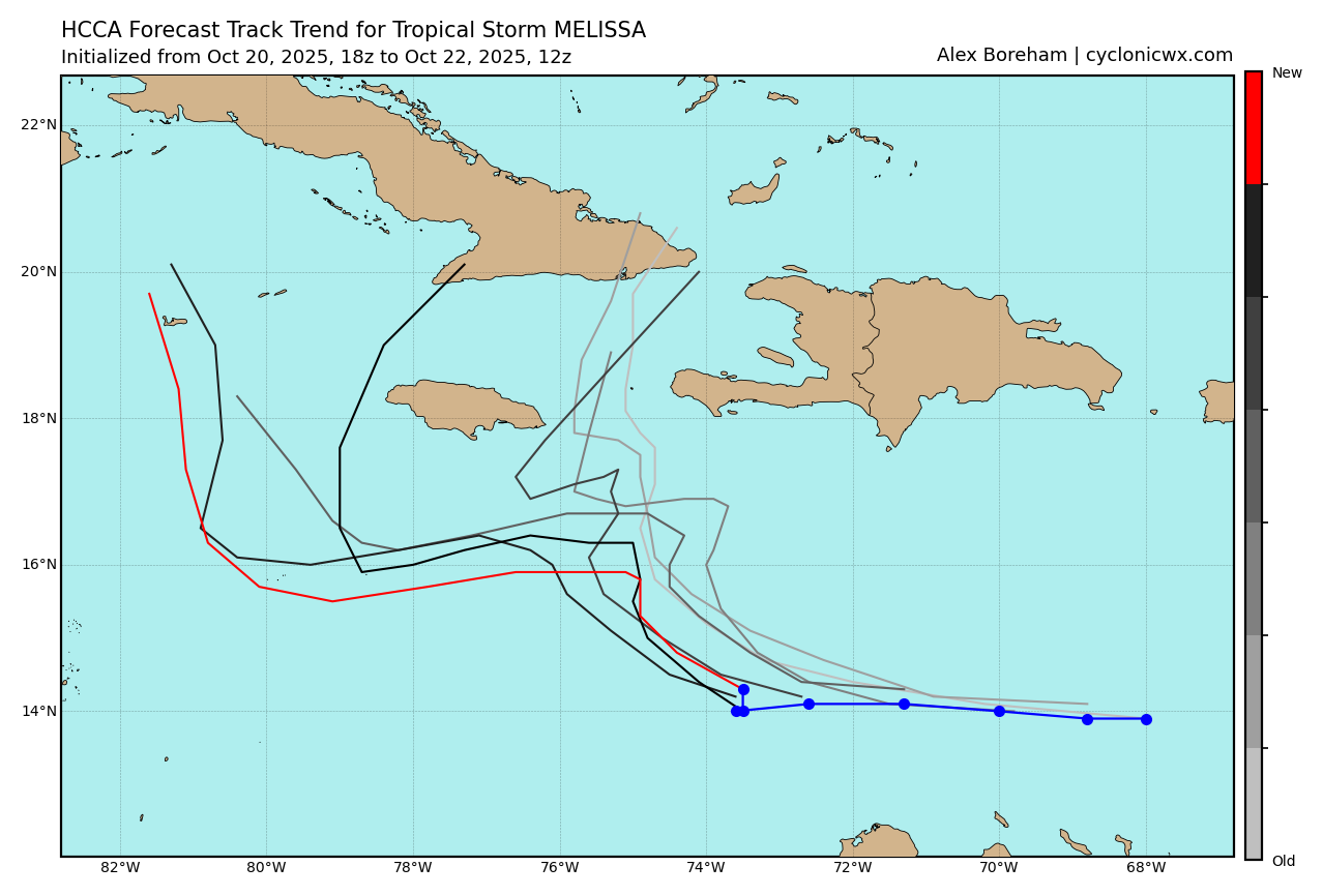
NATL: MELISSA - Models
Moderators: hurricanetrack, S2k Moderators

The posts in this forum are NOT official forecasts and should not be used as such. They are just the opinion of the poster and may or may not be backed by sound meteorological data. They are NOT endorsed by any professional institution or STORM2K. For official information, please refer to products from the National Hurricane Center and National Weather Service.

Re: NATL: MELISSA - Models
3 likes
-
Blown Away

- S2K Supporter

- Posts: 10217
- Joined: Wed May 26, 2004 6:17 am
Re: NATL: MELISSA - Models
kevin wrote:Very significant shift SW for GEFS 06z compared to 00z. The 06z operational is still battling the consensus, but if it also flips soon then GFS is also on board with the Euro solution. Stats for the 2 last ensembles out to +84 hr.
Hispaniola landfall = 26% (8/31) in 00z -> 6% (2/31) in 06z
Between Cuba and Jamaica = 6% (2/31) in 00z -> 3% (1/31) in 06z
Jamaica landfall = 13% (4/31) in 00z -> 10% (3/31) in 06z
South of Jamaica = 55% (17/31) in 00z -> 77% (24/31) in 06z
Do not develop = 0% (0/31) in 00z -> 3% (1/31) in 06z
06z
https://i.imgur.com/wOOJ9v2.png
00z
https://i.imgur.com/F6VnDfE.png
Thank you for doing the breakdown, always appreciate that!
I wonder if Melissa will be one of those rare times the Ukmet was right all along.
0 likes
Hurricane Eye Experience: David 79, Irene 99, Frances 04, Jeanne 04, Wilma 05… Hurricane Brush Experience: Andrew 92, Erin 95, Floyd 99, Matthew 16, Irma 17, Ian 22, Nicole 22…
-
Blown Away
- S2K Supporter
- Posts: 10217
- Joined: Wed May 26, 2004 6:17 am
Re: NATL: MELISSA - Models
GFS trend... 06z had significant slow down in short range compared to previous runs. IMO, the GFS will be backing off the quick NE movement over Hispaniola and moving more in line with other models sometime today.
1 likes
Hurricane Eye Experience: David 79, Irene 99, Frances 04, Jeanne 04, Wilma 05… Hurricane Brush Experience: Andrew 92, Erin 95, Floyd 99, Matthew 16, Irma 17, Ian 22, Nicole 22…


Re: NATL: MELISSA - Models
Have to keep an eye on that trough approaching the Gulf coast it about a week. If it digs deeper and slows down, then a CONUS impact not out of the question. Meanwhile it appears that a consensus is forming from the ensembles of a slow W-SW track south of JAM. If this pans out, we're probably looking at a MH in the western Caribbean.
1 likes

Re: NATL: MELISSA - Models
The 06z hurricane model runs so far seem less west than the 00z suite. HWRF is still comparable to the GFS/ICON. HAFS-A is a little closer to that side of the forecast trend too, while the HAFS-B is so far mostly similar (yet a little less west) than 00z.
0 likes
Irene '11 Sandy '12 Hermine '16 5/15/2018 Derecho Fay '20 Isaias '20 Elsa '21 Henri '21 Ida '21
I am only a meteorology enthusiast who knows a decent amount about tropical cyclones. Look to the professional mets, the NHC, or your local weather office for the best information.
I am only a meteorology enthusiast who knows a decent amount about tropical cyclones. Look to the professional mets, the NHC, or your local weather office for the best information.
Re: NATL: MELISSA - Models
HWRF has Melissa slow down in the gap between Haiti, Jamaica, and Cuba as a Cat 3. An incredibly perilous position for anyone on those islands.
HMON is closer to Jamaica this run, but the center still passes to the south.
HAFS-A/B are comparable to last run but a little weaker (900-910mb instead of sub-900). Both got a little closer to Haiti and Jamaica than last run, then dipped back south and bombed out into Cat 5s in the WCar.
HMON is closer to Jamaica this run, but the center still passes to the south.
HAFS-A/B are comparable to last run but a little weaker (900-910mb instead of sub-900). Both got a little closer to Haiti and Jamaica than last run, then dipped back south and bombed out into Cat 5s in the WCar.
0 likes
Irene '11 Sandy '12 Hermine '16 5/15/2018 Derecho Fay '20 Isaias '20 Elsa '21 Henri '21 Ida '21
I am only a meteorology enthusiast who knows a decent amount about tropical cyclones. Look to the professional mets, the NHC, or your local weather office for the best information.
I am only a meteorology enthusiast who knows a decent amount about tropical cyclones. Look to the professional mets, the NHC, or your local weather office for the best information.
Re: NATL: MELISSA - Models
There may be some validity to this.
HAFS takes it to 902mb SW of Jamaica
https://www.tropicaltidbits.com/analysi ... 13L_43.png
HAFS takes it to 902mb SW of Jamaica
https://www.tropicaltidbits.com/analysi ... 13L_43.png
0 likes
-
MEANINGLESS_NUMBERS
- Category 1

- Posts: 449
- Joined: Mon Nov 02, 2020 1:43 pm
Re: NATL: MELISSA - Models
GCANE wrote:There may be some validity to this.
HAFS takes it to 902mb SW of Jamaica
https://www.tropicaltidbits.com/analysi ... 13L_43.png
Crazy that at 5 days we are seeing realistic spread from Cat 5 to TS.
1 likes
Emily '87, Felix '95, Gert '99, Fabian '03, Humberto '19, Paulette '20, Teddy '20, Fiona '22, Lee '23, Ernesto '24, Humberto/Imelda '25
-
MHC Tracking
- Tropical Storm

- Posts: 200
- Joined: Mon Mar 15, 2021 10:05 am
Re: NATL: MELISSA - Models
HAFS simulated IR seems to have glitched, even in the Western Caribbean the tropopause isn't this high.

0 likes
-
MHC Tracking
- Tropical Storm
- Posts: 200
- Joined: Mon Mar 15, 2021 10:05 am
Re: NATL: MELISSA - Models
On another note, the 6z HAFS runs are both quite far south (in particular the B). If the system took that track in reality, it could be far enough west when the trough came along to bring impacts to New England (the 0z ECM has a much more easterly track and takes it directly to Nova Scotia).
2 likes

Re: NATL: MELISSA - Models
One thing for sure that the AI models like Google's & EC's didn't do well with Melissa was its interaction with the low level jet as it tracked across the eastern Caribbean, they were both erroneously showing a track across Hispaniola. Maybe they're not the models to look at before a storm is formed.
2 likes
Re: NATL: MELISSA - Models
MHC Tracking wrote:HAFS simulated IR seems to have glitched, even in the Western Caribbean the tropopause isn't this high.
https://cdn.discordapp.com/attachments/981328327199559760/1430535925313568902/hafsb_satIR_13L_43.png?ex=68fa21e6&is=68f8d066&hm=0a9b11bb24195cbf4caa078461abff9d72461a4875050da6b22aa787b68cb495&
Hurricane Eta was able to achieve a very similar T8.0+ IR appearance due to the late season WCar tropopause, despite “only” being 130-140 kt. So if Melissa were to bomb out to the degree that the HAFS models are showing, this IR presentation is very possible.
1 likes
Irene '11 Sandy '12 Hermine '16 5/15/2018 Derecho Fay '20 Isaias '20 Elsa '21 Henri '21 Ida '21
I am only a meteorology enthusiast who knows a decent amount about tropical cyclones. Look to the professional mets, the NHC, or your local weather office for the best information.
I am only a meteorology enthusiast who knows a decent amount about tropical cyclones. Look to the professional mets, the NHC, or your local weather office for the best information.
-
MHC Tracking
- Tropical Storm
- Posts: 200
- Joined: Mon Mar 15, 2021 10:05 am
Re: NATL: MELISSA - Models
aspen wrote:MHC Tracking wrote:HAFS simulated IR seems to have glitched, even in the Western Caribbean the tropopause isn't this high.
https://cdn.discordapp.com/attachments/981328327199559760/1430535925313568902/hafsb_satIR_13L_43.png?ex=68fa21e6&is=68f8d066&hm=0a9b11bb24195cbf4caa078461abff9d72461a4875050da6b22aa787b68cb495&
Hurricane Eta was able to achieve a very similar T8.0+ IR appearance due to the late season WCar tropopause, despite “only” being 130-140 kt. So if Melissa were to bomb out to the degree that the HAFS models are showing, this IR presentation is very possible.
Eta was not a T8.0, it reached 8.2 via raw ADT values. Dvorak T numbers from TAFB and SAB were 6.5 and 7.0, the latter being the maximum justifiable value as the eye peaked at OW.
1 likes
Re: NATL: MELISSA - Models
MHC Tracking wrote:HAFS simulated IR seems to have glitched, even in the Western Caribbean the tropopause isn't this high.
https://cdn.discordapp.com/attachments/981328327199559760/1430535925313568902/hafsb_satIR_13L_43.png?ex=68fa21e6&is=68f8d066&hm=0a9b11bb24195cbf4caa078461abff9d72461a4875050da6b22aa787b68cb495&
Many times I have seen strong tropical cyclones punch thru the tropopause.
They become viscous monsters.
0 likes
-
MHC Tracking
- Tropical Storm
- Posts: 200
- Joined: Mon Mar 15, 2021 10:05 am
Re: NATL: MELISSA - Models
NDG wrote:One thing for sure that the AI models like Google's & EC's didn't do well with Melissa was its interaction with the low level jet as it tracked across the eastern Caribbean, they were both erroneously showing a track across Hispaniola. Maybe they're not the models to look at before a storm is formed.
If I had to guess, there's some intake of GFS data into GDM, as the GFS-core models have been rather arrogant with the outlandish solution of a 90 degree northerly turn into Hispaniola
1 likes
Re: NATL: MELISSA - Models
MHC Tracking wrote:NDG wrote:One thing for sure that the AI models like Google's & EC's didn't do well with Melissa was its interaction with the low level jet as it tracked across the eastern Caribbean, they were both erroneously showing a track across Hispaniola. Maybe they're not the models to look at before a storm is formed.
If I had to guess, there's some intake of GFS data into GDM, as the GFS-core models have been rather arrogant with the outlandish solution of a 90 degree northerly turn into Hispaniola
Yes that would be a good guess but the EC's AI also had the same erroneous solution.
Edit: BTW, looks like the last time the GFS was upgraded was back in 2021, how often does it usually gets upgraded? I can't recall.
0 likes

Re: NATL: MELISSA - Models
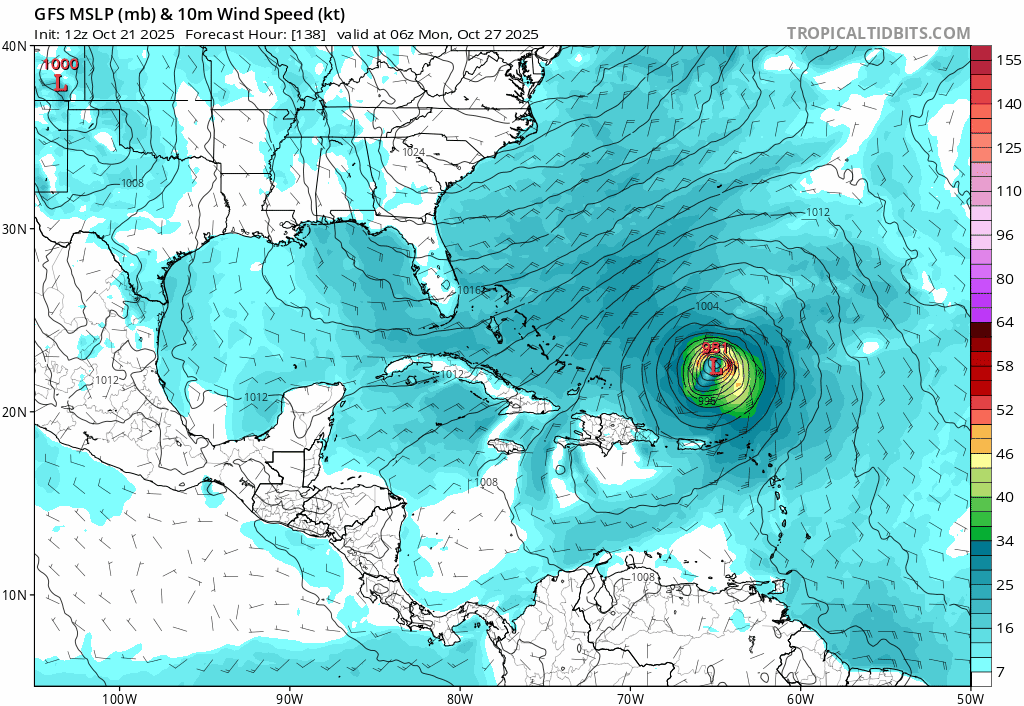
06z, Oct/22/2026, hurricane model blend, Melissa
--- Model peak intensity ---
HWRF = 944mb/112kt
HMON = 935mb/119kt
HAFS-A = 901mb/146kt
HAFS-B = 900mb/144kt
--- Hurricane model blend ---
The new 06z hurricane models are somewhat similar to the 00z ones. They show slightly delayed intensification (6 - 12 hours later) and as such this blend 'only' peaks at 127 kt. But all models (with the exception of HWRF due to some land interaction) are still intensifying at +126 hr. The blend also shows a 60 kt peak in the coming 12 hours before struggling around 40 - 50 kt for 2 more days. I think the brief 60 kt peak is not realistic and simply a result of the initialization of Melissa. Like with the 00z cycle, HWRF is the only model which passes between Jamaica and Cuba and the other 3 models go south of Jamaica. HMON is a bit closer to Jamaica compared to 00z, but HAFS-A and HAFS-B are even farther south than they were in 00z and as such the blend average track doesn't really change and still passes close to but south of Jamaica. If the track shifts farther north and Melissa hits Jamaica, this would probably be around cat 3 intensity based on this blend. Uncertainty has gone down compared to 00z: the standard deviation in position at +72/+96/+108hr is now 45/95/130 miles, respectively, instead of 95/120/160 miles in the 00z blend. Still, this uncertainty window is big enough for significant differences in impact with respect to landfalls so this remains a very difficult forecast.
Blend
PEAK: 920 mb @ 126 hrs | 127 kt @ 126 hrs
ACE (0 - 126 hrs) = 13.4
Time (hr) / Pressure (mb) / Wind (kt) / Location (lat, lon [deg])
00 / 999 / 44 /14.0N, 73.3W
06 / 995 / 60
12 / 995 / 51
18 / 997 / 49 / 15.0N, 74.1W
24 / 998 / 42
30 / 998 / 45
36 / 998 / 47 / 15.2N, 75.4W
42 / 996 / 48
48 / 995 / 49
54 / 994 / 49 / 15.8N, 75.0W
60 / 993 / 45
66 / 988 / 61
72 / 985 / 57 / 16.4N, 75.4W
78 / 981 / 68 - C1
84 / 972 / 76
90 / 962 / 94 / 16.5N, 76.2W - C2
96 / 955 / 99 - C3
102 / 946 / 108
108 / 935 / 119 / 16.7N, 77.6W - C4
114 / 932 / 120
120 / 926 / 123
126 / 920 / 127 / 17.0N, 78.3W
--- Previous blend analyses ---
00z, Oct 22 = 911mb/134kt
Forecast track (weighted average of the hurricane model tracks)
6 likes
Re: NATL: MELISSA - Models
MHC Tracking wrote:aspen wrote:MHC Tracking wrote:HAFS simulated IR seems to have glitched, even in the Western Caribbean the tropopause isn't this high.
https://cdn.discordapp.com/attachments/981328327199559760/1430535925313568902/hafsb_satIR_13L_43.png?ex=68fa21e6&is=68f8d066&hm=0a9b11bb24195cbf4caa078461abff9d72461a4875050da6b22aa787b68cb495&
Hurricane Eta was able to achieve a very similar T8.0+ IR appearance due to the late season WCar tropopause, despite “only” being 130-140 kt. So if Melissa were to bomb out to the degree that the HAFS models are showing, this IR presentation is very possible.
Eta was not a T8.0, it reached 8.2 via raw ADT values. Dvorak T numbers from TAFB and SAB were 6.5 and 7.0, the latter being the maximum justifiable value as the eye peaked at OW.
I should’ve clarified that I meant raw T8.0+. It did have the CDO thickness and temperature you’d expect from a T8.0 — just a huge donut of CDG — even though it actually wasn’t one.
But another CDO like that is definitely on the table if the Euro/HAFS track verifies.
1 likes
Irene '11 Sandy '12 Hermine '16 5/15/2018 Derecho Fay '20 Isaias '20 Elsa '21 Henri '21 Ida '21
I am only a meteorology enthusiast who knows a decent amount about tropical cyclones. Look to the professional mets, the NHC, or your local weather office for the best information.
I am only a meteorology enthusiast who knows a decent amount about tropical cyclones. Look to the professional mets, the NHC, or your local weather office for the best information.

Re: NATL: MELISSA - Models
3 likes
The following post is NOT an official forecast and should not be used as such. It is just the opinion of the poster and may or may not be backed by sound meteorological data. It is NOT endorsed by any professional institution including storm2k.org For Official Information please refer to the NHC and NWS products.
Return to “Active Storms/Invests - Atlantic/EastPAC/CentralPAC/MED”
Who is online
Users browsing this forum: pepecool20 and 75 guests