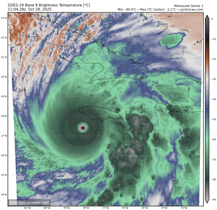
NATL: MELISSA - Hurricane - Discussion

Current storms and invests:

Moderators: hurricanetrack, S2k Moderators


The posts in this forum are NOT official forecasts and should not be used as such. They are just the opinion of the poster and may or may not be backed by sound meteorological data. They are NOT endorsed by any professional institution or STORM2K. For official information, please refer to products from the National Hurricane Center and National Weather Service.

Help Support Storm2K
Message
Author
MEANINGLESS_NUMBERS
Category 1
Category 1
Posts: 484
Joined: Mon Nov 02, 2020 1:43 pm

Re: NATL: MELISSA - Hurricane - Discussion

#2181 Postby MEANINGLESS_NUMBERS » Tue Oct 28, 2025 6:21 am


This is a historically intense storm. For landfall to be happening at its absolute peak is so unfortunate
2 likes   
Emily '87, Felix '95, Gert '99, Fabian '03, Humberto '19, Paulette '20, Teddy '20, Fiona '22, Lee '23, Ernesto '24, Humberto/Imelda '25

User avatar
Kazmit
Category 5
Category 5
Posts: 2245
Age: 22
Joined: Mon Jul 25, 2016 8:49 am
Location: Bermuda

Re: NATL: MELISSA - Hurricane - Discussion

#2182 Postby Kazmit » Tue Oct 28, 2025 6:21 am

C’mon recon… :roll:
0 likes   
Igor 2010, Sandy 2012, Fay 2014, Gonzalo 2014, Joaquin 2015, Nicole 2016, Humberto 2019, Imelda 2025

I am only a tropical weather enthusiast. My predictions are not official and may or may not be backed by sound meteorological data. For official information, please refer to the NHC and NWS products.

User avatar
Beef Stew
Category 2
Category 2
Posts: 633
Joined: Sat May 30, 2020 11:31 am
Location: South Florida

Re: NATL: MELISSA - Hurricane - Discussion

#2183 Postby Beef Stew » Tue Oct 28, 2025 6:22 am

ATDoel wrote:Looks like the eye is growing larger? I thought they usually constricted before landfall


The eye was contracting late last night/early this morning, but over the past few hours seems to have stabilized if not outright expanded. My thought is Melissa underwent an eyewall meld in the early morning hours, and recently has stabilized following this, and may now even be strengthening again.
1 likes   

User avatar
Kazmit
Category 5
Category 5
Posts: 2245
Age: 22
Joined: Mon Jul 25, 2016 8:49 am
Location: Bermuda

Re: NATL: MELISSA - Hurricane - Discussion

#2184 Postby Kazmit » Tue Oct 28, 2025 6:23 am

MEANINGLESS_NUMBERS wrote:


This is a historically intense storm. For landfall to be happening at its absolute peak is so unfortunate

I think, given its satellite appearance and landfall near peak intensity, that Melissa will be referred to as the “Haiyan of the Atlantic” in years to come.
1 likes   
Igor 2010, Sandy 2012, Fay 2014, Gonzalo 2014, Joaquin 2015, Nicole 2016, Humberto 2019, Imelda 2025

I am only a tropical weather enthusiast. My predictions are not official and may or may not be backed by sound meteorological data. For official information, please refer to the NHC and NWS products.

grapealcoholic
Category 2
Category 2
Posts: 703
Joined: Tue Aug 10, 2021 3:26 pm

Re: NATL: MELISSA - Hurricane - Discussion

#2185 Postby grapealcoholic » Tue Oct 28, 2025 6:25 am

best the storm has ever looked

next couple hours will be interesting
1 likes   

User avatar
Hypercane_Kyle
Category 5
Category 5
Posts: 3462
Joined: Sat Mar 07, 2015 7:58 pm
Location: Cape Canaveral, FL

Re: NATL: MELISSA - Hurricane - Discussion

#2186 Postby Hypercane_Kyle » Tue Oct 28, 2025 6:28 am

If there was an EWRC last night, it appears to have finished at the worst moment - Melissa appears to be making one final push for peak intensity. CDO temps aren't quite as cool but it is much more round with the eye as clear as it's ever been.

Image
5 likes   
My posts are my own personal opinion, defer to the National Hurricane Center (NHC) and other NOAA products for decision making during hurricane season.

User avatar
GCANE
S2K Supporter
S2K Supporter
Posts: 11965
Joined: Mon Oct 22, 2007 8:03 am

Re: NATL: MELISSA - Hurricane - Discussion

#2187 Postby GCANE » Tue Oct 28, 2025 6:30 am

Eye does appear to be growing before landfall.
This is the most intense lightning rate I have seen so far.

https://www.weathernerds.org/satellite/ ... itgefs=Off
0 likes   

michelinj
Tropical Depression
Tropical Depression
Posts: 73
Joined: Mon Aug 06, 2018 4:59 pm

Re: NATL: MELISSA - Hurricane - Discussion

#2188 Postby michelinj » Tue Oct 28, 2025 6:31 am

Hypercane_Kyle wrote:If there was an EWRC last night, it appears to have finished at the worst moment - Melissa appears to be making one final push for peak intensity. CDO temps aren't quite as cool but it is much more round with the eye as clear as it's ever been.

https://i.imgur.com/B2P3sF7.png

The sun is coming up at the moment and probably causing that slightly less cool CDO, no reflection on the storm I'd imagine, unfortunately
1 likes   

michelinj
Tropical Depression
Tropical Depression
Posts: 73
Joined: Mon Aug 06, 2018 4:59 pm

Re: NATL: MELISSA - Hurricane - Discussion

#2189 Postby michelinj » Tue Oct 28, 2025 6:31 am

Kazmit wrote:
MEANINGLESS_NUMBERS wrote:


This is a historically intense storm. For landfall to be happening at its absolute peak is so unfortunate

I think, given its satellite appearance and landfall near peak intensity, that Melissa will be referred to as the “Haiyan of the Atlantic” in years to come.

Make that -2.97C
3 likes   

User avatar
Hypercane_Kyle
Category 5
Category 5
Posts: 3462
Joined: Sat Mar 07, 2015 7:58 pm
Location: Cape Canaveral, FL

Re: NATL: MELISSA - Hurricane - Discussion

#2190 Postby Hypercane_Kyle » Tue Oct 28, 2025 6:32 am

Eye dryness has risen to -2.97C. Significantly dryer than any tropical cyclone ever recorded. Don't know how much that matters in the grand scheme of things but it's worth noting.
Last edited by Hypercane_Kyle on Tue Oct 28, 2025 6:32 am, edited 1 time in total.
1 likes   
My posts are my own personal opinion, defer to the National Hurricane Center (NHC) and other NOAA products for decision making during hurricane season.

User avatar
Beef Stew
Category 2
Category 2
Posts: 633
Joined: Sat May 30, 2020 11:31 am
Location: South Florida

Re: NATL: MELISSA - Hurricane - Discussion

#2191 Postby Beef Stew » Tue Oct 28, 2025 6:32 am

We're about to see the sunrise over one of the most impressive hurricanes ever in the Atlantic. The "incredible satellite images" thread is about to have some stunning entries.
0 likes   

User avatar
ouragans
Category 2
Category 2
Posts: 501
Age: 54
Joined: Sun Jun 12, 2011 12:09 pm
Location: Abymes, Guadeloupe F.W.I
Contact:

Re: NATL: MELISSA - Hurricane - Discussion

#2192 Postby ouragans » Tue Oct 28, 2025 6:33 am

Blown Away wrote:[url]https://i.postimg.cc/527rWTSZ/Jamaica1.jpg [/url]

[url]https://i.postimg.cc/Fsnbr4wr/Jamaica2.jpg [/url]

Melissa aiming for the Black River to Crane Corner area...

Do you consider a NNE track or a NE turn before landfall?
0 likes   
Personal forecast disclaimer
This post is a personal point of view, not an information. Please refer to official statements for life-threatening decisions.

David '79, Frederic '79, Hugo '89, Iris, Luis & Marilyn '95, Georges '98, Lenny '99, Dean '07, Irma '17, Maria '17, Fiona '22, Philippe '23, Tammy '23
16°13'33.3,"6N -61°36'39.5"W

User avatar
chris_fit
Category 5
Category 5
Posts: 3261
Age: 42
Joined: Wed Sep 10, 2003 11:58 pm
Location: Tampa Bay Area, FL

Re: NATL: MELISSA - Hurricane - Discussion

#2193 Postby chris_fit » Tue Oct 28, 2025 6:34 am

Image
4 likes   

User avatar
mrbagyo
Category 5
Category 5
Posts: 3872
Age: 33
Joined: Thu Apr 12, 2012 9:18 am
Location: 14.13N 120.98E
Contact:

Re: NATL: MELISSA - Hurricane - Discussion

#2194 Postby mrbagyo » Tue Oct 28, 2025 6:34 am

For what it's worth, this will be another upper echelon DAY TIME landfall.
2 likes   
The posts in this forum are NOT official forecast and should not be used as such. They are just the opinion of the poster and may or may not be backed by sound meteorological data. They are NOT endorsed by any professional institution or storm2k.org. For official information, please refer to RSMC, NHC and NWS products.

grapealcoholic
Category 2
Category 2
Posts: 703
Joined: Tue Aug 10, 2021 3:26 pm

Re: NATL: MELISSA - Hurricane - Discussion

#2195 Postby grapealcoholic » Tue Oct 28, 2025 6:36 am

880s still in play
0 likes   

User avatar
syfr
S2K Supporter
S2K Supporter
Posts: 220
Age: 106
Joined: Fri Oct 26, 2012 7:33 pm
Location: East Central NC

Re: NATL: MELISSA - Hurricane - Discussion

#2196 Postby syfr » Tue Oct 28, 2025 6:38 am

kevin wrote:Flightaware now mentions that NOAA42 is expected to depart in 20 minutes. Perhaps something is wrong with the other planes and NOAA42 is going again instead. I don't know, all we can do is wait and see.


These planes have taken a beating in the past few days.
0 likes   
I'm not a meteorologist, I'm an electronics engineer. While I can probably fix your toaster oven, you're not going to learn about storms from me!

New Mexico had no hurricanes. Then I moved to NC right before Fran.....

tolakram
Admin
Admin
Posts: 20152
Age: 62
Joined: Sun Aug 27, 2006 8:23 pm
Location: Florence, KY (name is Mark)

Re: NATL: MELISSA - Hurricane - Discussion

#2197 Postby tolakram » Tue Oct 28, 2025 6:38 am

Saved loops, a few bad frames unfortunately.

Image

Image
5 likes   
M a r k
- - - - -
Join us in chat: Storm2K Chatroom Invite. Android and IOS apps also available.

The posts in this forum are NOT official forecasts and should not be used as such. Posts are NOT endorsed by any professional institution or STORM2K.org. For official information and forecasts, please refer to NHC and NWS products.

User avatar
Kazmit
Category 5
Category 5
Posts: 2245
Age: 22
Joined: Mon Jul 25, 2016 8:49 am
Location: Bermuda

Re: NATL: MELISSA - Hurricane - Discussion

#2198 Postby Kazmit » Tue Oct 28, 2025 6:39 am

mrbagyo wrote:For what it's worth, this will be another upper echelon DAY TIME landfall.

The storm chaser videos could rival Dorian.
0 likes   
Igor 2010, Sandy 2012, Fay 2014, Gonzalo 2014, Joaquin 2015, Nicole 2016, Humberto 2019, Imelda 2025

I am only a tropical weather enthusiast. My predictions are not official and may or may not be backed by sound meteorological data. For official information, please refer to the NHC and NWS products.

User avatar
Category5Kaiju
Category 5
Category 5
Posts: 4258
Joined: Thu Dec 24, 2020 12:45 pm
Location: Seattle

Re: NATL: MELISSA - Hurricane - Discussion

#2199 Postby Category5Kaiju » Tue Oct 28, 2025 6:39 am

Well, just woke up and expected to see a storm that was somewhat weaker than last night.

Boy was I wrong....901 MBAR?! And it still looks like a super typhoon. Melissa seems to be one of those extremely rare storms that steadily intensify and continue to fend off any major disruptive EWRCs. Praying for Jamaica during this moment.
1 likes   
Unless explicitly stated, all info in my posts is based on my own opinions and observations. Tropical storms and hurricanes can be extremely dangerous. Do not think you can beat Mother Nature. Refer to an accredited weather research agency or meteorologist if you need to make serious decisions regarding an approaching storm.

User avatar
Beef Stew
Category 2
Category 2
Posts: 633
Joined: Sat May 30, 2020 11:31 am
Location: South Florida

Re: NATL: MELISSA - Hurricane - Discussion

#2200 Postby Beef Stew » Tue Oct 28, 2025 6:41 am

grapealcoholic wrote:880s still in play


If she's in the 880's I'll be beyond shocked. She certainly has (and has had, for nearly the past 24 hours) the satellite appearance for it though.
2 likes   


Return to “Active Storms/Invests - Atlantic/EastPAC/CentralPAC/MED”

Who is online

Users browsing this forum: No registered users and 138 guests