Hurricane Kiko Advisory Number 31
NWS Central Pacific Hurricane Center Honolulu HI EP112025
Issued by NWS National Hurricane Center Miami FL
1100 AM HST Sun Sep 07 2025
...AIR FORCE RESERVE HURRICANE HUNTERS FIND THAT KIKO CONTINUES
TO WEAKEN...
...EXPECTED TO PASS NORTH OF THE HAWAIIAN ISLANDS ON TUESDAY AND
WEDNESDAY...
SUMMARY OF 1100 AM HST...2100 UTC...INFORMATION
-----------------------------------------------
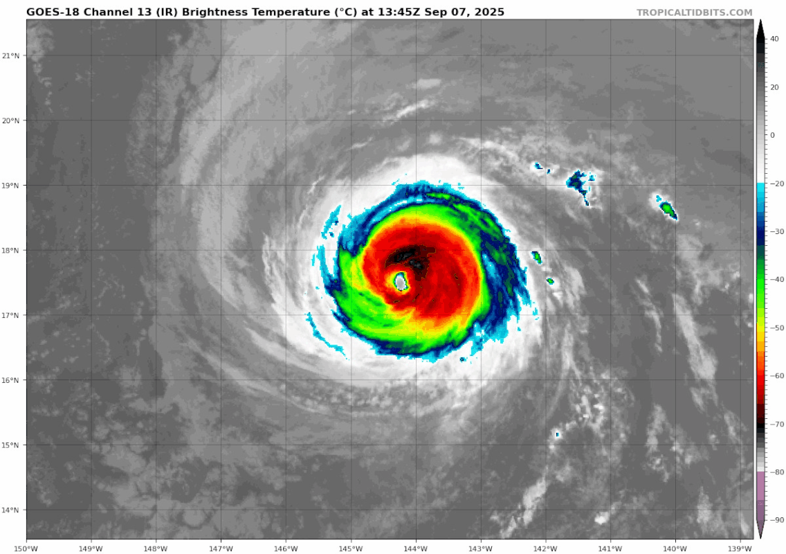
LOCATION...18.1N 145.5W
ABOUT 635 MI...1025 KM E OF HILO HAWAII
ABOUT 835 MI...1345 KM ESE OF HONOLULU HAWAII
MAXIMUM SUSTAINED WINDS...110 MPH...175 KM/H
PRESENT MOVEMENT...WNW OR 300 DEGREES AT 13 MPH...20 KM/H
MINIMUM CENTRAL PRESSURE...974 MB...28.77 INCHES
WATCHES AND WARNINGS
--------------------
There are no coastal watches or warnings in effect.
Interests in the Hawaiian Islands should monitor the progress of
Kiko.
DISCUSSION AND OUTLOOK
----------------------
At 1100 AM HST (2100 UTC), the center of Hurricane Kiko was located
near latitude 18.1 North, longitude 145.5 West. Kiko is moving
toward the west-northwest near 13 mph (20 km/h), and this general
motion with a slight increase in forward speed is expected through
Wednesday. On the forecast track, the center of Kiko is expected to
pass north of the Hawaiian Islands on Tuesday and Wednesday.
Reports from an Air Force Reserve Hurricane Hunter aircraft indicate
that maximum sustained winds have decreased to near 110 mph (175
km/h) with higher gusts. Additional weakening is forecast during
the next few days, and Kiko is expected to become a tropical storm
by late Monday or Monday night.
Hurricane-force winds extend outward up to 30 miles (45 km) from the
center and tropical-storm-force winds extend outward up to 80 miles
(130 km).
The minimum central pressure based on dropsonde data is 974 mb
(28.77 inches).
HAZARDS AFFECTING LAND
----------------------
Key messages for Kiko can be found in the Tropical Cyclone
Discussion under AWIPS header HFOTCDCP4 and WMO header WTPA44 PHFO.
SURF: Swells generated by Kiko are expected to begin reaching the
Big Island and Maui today. These swells will gradually build
and are forecast to peak along east-facing exposures of the Hawaiian
Islands late Monday through midweek, potentially producing
life-threatening surf and rip currents. Listen for later advisories
and possible warnings from the National Weather Service.
NEXT ADVISORY
-------------
Next complete advisory at 500 PM HST.
$$
Forecaster Berg
————————————————————————————————————
Hurricane Kiko Discussion Number 31
NWS Central Pacific Hurricane Center Honolulu HI EP112025
Issued by NWS National Hurricane Center Miami FL
1100 AM HST Sun Sep 07 2025
Kiko's eye has become a bit cloud filled during the past few hours,
and cloud-top temperatures around the eye have been gradually
warming. An Air Force Reserve Hurricane Hunter aircraft is
currently investigating the hurricane and measured a 700-mb
flight-level wind of 105 kt in the northeastern quadrant, as well
as a minimum pressure up to 974 mb. Based on the aircraft data,
the current intensity is set at 95 kt, which is also in line with
the latest objective satellite estimates.
The west-northwestward motion of 300/11 kt continues, and a
slightly faster speed on that trajectory is expected at least
through day 4 while Kiko remains on the southwestern periphery of a
mid-level ridge. Based on this motion, Kiko is expected to pass to
the north of the Hawaiian Islands on Tuesday and Wednesday, and the
most reliable track models remain in good agreement on this
scenario. The track guidance is again a little faster with Kiko as
it passes to the north of the islands, and the NHC track forecast
is a bit faster than the previous prediction starting in about 24
hours, but there is no appreciable change in the cross-track
direction. Based on the new forecast, and accounting for typical
forecast errors, there is currently less than a 10 percent chance
of tropical-storm-force winds occurring at any location on the
Hawaiian Islands, and tropical storm watches are not required.
Cool water temperatures appear to be contributing to Kiko's current
weakening. Moderate southwesterly vertical shear is forecast to
develop over Kiko in about 12-18 hours, and that, along with a very
dry surrounding environment, should lead to even quicker weakening.
The new NHC intensity forecast closely follows the HCCA consensus
aids, and shows Kiko falling below hurricane intensity on Monday.
The shear appears to peak in about 48 hours (as much as 30-35 kt),
so if Kiko can survive that period, it's possible that the storm
may weaken more slowly in the latter part of the foreast,
especially with sea surface temperatures along its path expected to
warm to about 27 degrees Celsius by day 3.
Key Messages:
1. Kiko is forecast to pass north of the Hawaiian Islands on Tuesday
and Wednesday. While the risk of direct impacts on the islands
appears to be decreasing, interests there should continue to monitor
Kiko's progress and the latest forecast.
2. Swells generated by Kiko are expected to begin reaching the Big
Island and Maui today. These swells will gradually build and are
forecast to peak along east-facing exposures of the Hawaiian
Islands late Monday through midweek, potentially producing
life-threatening surf and rip currents. Listen for later advisories
and possible warnings from the National Weather Service.
FORECAST POSITIONS AND MAX WINDS
INIT 07/2100Z 18.1N 145.5W 95 KT 110 MPH
12H 08/0600Z 19.0N 147.1W 85 KT 100 MPH
24H 08/1800Z 20.2N 149.3W 70 KT 80 MPH
36H 09/0600Z 21.4N 151.7W 60 KT 70 MPH
48H 09/1800Z 22.6N 154.2W 55 KT 65 MPH
60H 10/0600Z 23.7N 156.9W 50 KT 60 MPH
72H 10/1800Z 24.6N 159.5W 45 KT 50 MPH
96H 11/1800Z 26.6N 163.9W 40 KT 45 MPH
120H 12/1800Z 28.3N 166.6W 35 KT 40 MPH
$$
Forecaster Berg