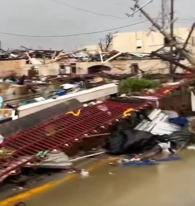
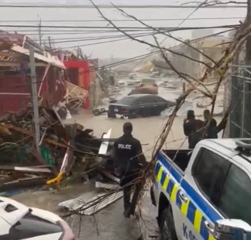
NATL: MELISSA - Hurricane - Discussion

Current storms and invests:

Moderators: hurricanetrack, S2k Moderators


The posts in this forum are NOT official forecasts and should not be used as such. They are just the opinion of the poster and may or may not be backed by sound meteorological data. They are NOT endorsed by any professional institution or STORM2K. For official information, please refer to products from the National Hurricane Center and National Weather Service.

Help Support Storm2K
Message
Author
User avatar
eastcoastFL
Category 5
Category 5
Posts: 3993
Age: 43
Joined: Thu Apr 12, 2007 12:29 pm
Location: Palm City, FL

Re: NATL: MELISSA - Hurricane - Discussion

#2781 Postby eastcoastFL » Tue Oct 28, 2025 8:28 pm

Nimbus wrote:
Nuno wrote:Melissa after landfall looking like a "mature" cyclone. The october big eyed storms. Much larger eyewall.


Agreed these have large wind and precipitation fields and so damage is more widespread.
Larger eye hopefully won't go below 940 again NHC still kept her at cat 3 for destructive potential.
Cuba needs to get their final preps done.
At least she is moving faster now so the precip totals will only have hours not days.


Interesting enough the wind field hasn't changed at all over the past few days. Last advisory the NHC still had hurricane force winds 30 miles from center. It's basically a large tornado.
0 likes   
Personal Forecast Disclaimer:
The posts in this forum are NOT official forecast and should not be used as such. They are just the opinion of the poster and may or may not be backed by sound meteorological data. They are NOT endorsed by any professional institution or storm2k.org. For official information, please refer to the NHC and NWS products.

User avatar
eastcoastFL
Category 5
Category 5
Posts: 3993
Age: 43
Joined: Thu Apr 12, 2007 12:29 pm
Location: Palm City, FL

Re: NATL: MELISSA - Hurricane - Discussion

#2782 Postby eastcoastFL » Tue Oct 28, 2025 8:29 pm

aspen wrote:What’s going on with the AF plane? They’re circling at ~5200 gpm, still several hundred miles out from Melissa.


I've been wondering the same thing. I couldn't tell if maybe it was some other type of mission to sample the air. But it seems like an odd time and place for that.
0 likes   
Personal Forecast Disclaimer:
The posts in this forum are NOT official forecast and should not be used as such. They are just the opinion of the poster and may or may not be backed by sound meteorological data. They are NOT endorsed by any professional institution or storm2k.org. For official information, please refer to the NHC and NWS products.

User avatar
tropicwatch
Category 5
Category 5
Posts: 3426
Age: 61
Joined: Sat Jun 02, 2007 10:01 am
Location: Panama City Florida
Contact:

Re: NATL: MELISSA - Hurricane - Discussion

#2783 Postby tropicwatch » Tue Oct 28, 2025 8:30 pm

GITMO reporting sustained 38mph winds gusts to 61mph at 8:51pm eastern
0 likes   
Tropicwatch


Agnes 72', Eloise 75, Elena 85', Kate 85', Charley 86', Florence 88', Beryl 94', Dean 95', Erin 95', Opal 95', Earl 98', Georges 98', Ivan 2004', Arlene 2005', Dennis 2005', Ida 2009' Debby 2012' Irma 2017' Michael 2018'

User avatar
Kazmit
Category 5
Category 5
Posts: 2249
Age: 22
Joined: Mon Jul 25, 2016 8:49 am
Location: Bermuda

Re: NATL: MELISSA - Hurricane - Discussion

#2784 Postby Kazmit » Tue Oct 28, 2025 8:34 pm

CrazyC83 wrote:It also seems to be moving more northeast - that would give it a bit more time over water.

Well east after being west of the forecast its entire life. Watching this closely here in Bermuda.

Image
Last edited by Kazmit on Tue Oct 28, 2025 8:41 pm, edited 1 time in total.
1 likes   
Igor 2010, Sandy 2012, Fay 2014, Gonzalo 2014, Joaquin 2015, Nicole 2016, Humberto 2019, Imelda 2025

I am only a tropical weather enthusiast. My predictions are not official and may or may not be backed by sound meteorological data. For official information, please refer to the NHC and NWS products.

disassociated_vort
Tropical Wave
Tropical Wave
Posts: 3
Joined: Mon Oct 06, 2025 1:56 pm

Re: NATL: MELISSA - Hurricane - Discussion

#2785 Postby disassociated_vort » Tue Oct 28, 2025 8:36 pm

tropicwatch wrote:GITMO reporting sustained 38mph winds gusts to 61mph at 8:51pm eastern


I saw the base was partially evacutated of non-essential personnel. How vulnerable is GITMO to a landfalling storm like this?
0 likes   

User avatar
Beef Stew
Category 2
Category 2
Posts: 637
Joined: Sat May 30, 2020 11:31 am
Location: South Florida

Re: NATL: MELISSA - Hurricane - Discussion

#2786 Postby Beef Stew » Tue Oct 28, 2025 8:40 pm

aspen wrote:What’s going on with the AF plane? They’re circling at ~5200 gpm, still several hundred miles out from Melissa.


I've been wondering the same thing. Can't figure it out- they must be having a technical issue or something.
Last edited by Beef Stew on Tue Oct 28, 2025 8:44 pm, edited 1 time in total.
0 likes   

User avatar
Ptarmigan
Category 5
Category 5
Posts: 5343
Joined: Wed Aug 16, 2006 9:06 pm

Re: NATL: MELISSA - Hurricane - Discussion

#2787 Postby Ptarmigan » Tue Oct 28, 2025 8:41 pm

The damage in Jamaica is going to be horrendous. Melissa has broken many records. :eek: :double: :( :cry:
1 likes   

User avatar
Teban54
Category 5
Category 5
Posts: 3721
Joined: Sat May 19, 2018 1:19 pm

Re: NATL: MELISSA - Hurricane - Discussion

#2788 Postby Teban54 » Tue Oct 28, 2025 8:46 pm

Obviously Melissa has countless other more notable records that have been mentioned today, but here's another one: Melissa has the 8th longest duration as a Category 5 (among the 45 known Cat 5s), spending 1 day 11 hours at that intensity.

Many Cat 5s don't last long before weakening, often due to EWRCs. The two other Cat 5s this year only stayed there for 12 hours or less. Even many impressive Cat 5s, like Milton, Dorian and Maria, lasted a few hours less than Melissa.

The 7 storms that lasted longer than Melissa as Cat 5s are: Cuba 1932, Allen, Irma, Ivan, David, Mitch, and Isabel.
10 likes   

User avatar
cycloneye
Admin
Admin
Posts: 148285
Age: 69
Joined: Thu Oct 10, 2002 10:54 am
Location: San Juan, Puerto Rico

Re: NATL: MELISSA - Hurricane - Discussion

#2789 Postby cycloneye » Tue Oct 28, 2025 8:48 pm

4 likes   
Visit the Caribbean-Central America Weather Thread where you can find at first post web cams,radars
and observations from Caribbean basin members Click Here

User avatar
Hurricane2022
Category 5
Category 5
Posts: 1909
Joined: Tue Aug 23, 2022 11:38 pm
Location: Araçatuba, Brazil

Re: NATL: MELISSA - Hurricane - Discussion

#2790 Postby Hurricane2022 » Tue Oct 28, 2025 8:52 pm

0 likes   
Sorry for the bad English sometimes...!
For reliable and detailed information for any meteorological phenomenon, please consult the National Hurricane Center, Joint Typhoon Warning Center , or your local Meteo Center.

--------

ECCE OMNIA NOVA FACIAM (Ap 21,5).

User avatar
Hurricane2022
Category 5
Category 5
Posts: 1909
Joined: Tue Aug 23, 2022 11:38 pm
Location: Araçatuba, Brazil

Re: NATL: MELISSA - Hurricane - Discussion

#2791 Postby Hurricane2022 » Tue Oct 28, 2025 8:52 pm

3 likes   
Sorry for the bad English sometimes...!
For reliable and detailed information for any meteorological phenomenon, please consult the National Hurricane Center, Joint Typhoon Warning Center , or your local Meteo Center.

--------

ECCE OMNIA NOVA FACIAM (Ap 21,5).

edu2703
Category 1
Category 1
Posts: 360
Joined: Thu Aug 23, 2018 7:15 pm

Re: NATL: MELISSA - Hurricane - Discussion

#2792 Postby edu2703 » Tue Oct 28, 2025 8:55 pm

I'm watching the footage of the damage in Black River. Total destruction. The entire town is basically gone.

The damage is definitely consistent with a C5 hurricane.
2 likes   

bob rulz
Category 5
Category 5
Posts: 1711
Age: 35
Joined: Sat Jan 28, 2006 7:30 pm
Location: Salt Lake City, Utah

Re: NATL: MELISSA - Hurricane - Discussion

#2793 Postby bob rulz » Tue Oct 28, 2025 8:56 pm


Its satellite presentation could fool me, it certainly looks like it's rapidly reorganizing. Though looks can be deceiving. I don't think we can know for sure until a plane gets in there again.

What happened to the plane that sampled the storm right after emerging from the coast?
0 likes   

User avatar
ElectricStorm
Category 5
Category 5
Posts: 5121
Age: 24
Joined: Tue Aug 13, 2019 11:23 pm
Location: Skiatook, OK / Norman, OK

Re: NATL: MELISSA - Hurricane - Discussion

#2794 Postby ElectricStorm » Tue Oct 28, 2025 9:02 pm

Looks like the AF plane is going in now
0 likes   
B.S Meteorology, University of Oklahoma '25

Please refer to the NHC, NWS, or SPC for official information.

User avatar
Beef Stew
Category 2
Category 2
Posts: 637
Joined: Sat May 30, 2020 11:31 am
Location: South Florida

Re: NATL: MELISSA - Hurricane - Discussion

#2795 Postby Beef Stew » Tue Oct 28, 2025 9:04 pm

edu2703 wrote:I'm watching the footage of the damage in Black River. Total destruction. The entire town is basically gone.

The damage is definitely consistent with a C5 hurricane.


Do you have a link you could share?
0 likes   

MEANINGLESS_NUMBERS
Category 1
Category 1
Posts: 489
Joined: Mon Nov 02, 2020 1:43 pm

Re: NATL: MELISSA - Hurricane - Discussion

#2796 Postby MEANINGLESS_NUMBERS » Tue Oct 28, 2025 9:08 pm

Kazmit wrote:
CrazyC83 wrote:It also seems to be moving more northeast - that would give it a bit more time over water.

Well east after being west of the forecast its entire life. Watching this closely here in Bermuda.

https://i.ibb.co/xKgGVM7c/tccapture.gif


What site is this? I don’t have one that plots the forecast points as an overlay.
0 likes   
Emily '87, Felix '95, Gert '99, Fabian '03, Humberto '19, Paulette '20, Teddy '20, Fiona '22, Lee '23, Ernesto '24, Humberto/Imelda '25

edu2703
Category 1
Category 1
Posts: 360
Joined: Thu Aug 23, 2018 7:15 pm

Re: NATL: MELISSA - Hurricane - Discussion

#2797 Postby edu2703 » Tue Oct 28, 2025 9:09 pm

Beef Stew wrote:
edu2703 wrote:I'm watching the footage of the damage in Black River. Total destruction. The entire town is basically gone.

The damage is definitely consistent with a C5 hurricane.


Do you have a link you could share?


 https://x.com/volcaholic1/status/1983342092048076821


 https://x.com/DiggleMassyca/status/1983346327368138982


Image

Image

 https://x.com/TheInsiderPaper/status/1983334908518117876

1 likes   

Michele B
S2K Supporter
S2K Supporter
Posts: 1128
Joined: Thu Aug 25, 2016 8:08 am
Location: SWFL

Re: NATL: MELISSA - Hurricane - Discussion

#2798 Postby Michele B » Tue Oct 28, 2025 9:11 pm

Beef Stew wrote:
syfr wrote:The level of intensity that Jamaica took from Melissa is surprising. Are "perfect" storms like Melissa, particularly vulnerable to severe attenuation , in comparison to your normal run of the mill big blob Cat III or the like?


Generally, yes. The way I like to think of it is this: which is going to be an easier repair job if you crash it- a 2005 Ford F150 or a brand new Ferrari?

A category 5, especially an upper echelon one like Melissa, is a highly refined, highly sensitive heat engine. It performs at the highest standards as a cyclone can, but any little perturbation can quickly spiral and cause a huge disruption (think Delta in 2020) that can be difficult to recover from. A run of the mill cat 3, as you mentioned- or certainly a lesser storm- might be more resilient to having its circulation disrupted by land, shear, etc because it doesn’t have to be as efficient, as perfect by nature- that’s why it’s not a C4 or 5.

If circulation can persist, a former category 5 can reintensify at a good pace if conditions are favorable, but after traversing significant elevation it’s never a seamless process.


Great points. Also add the fact that the sea temps are nowhere as warm as they were on the south side of Jamaica. Not as much fuel for Melissa.
1 likes   
Cleo - 1964, Betsy - 1965, David - 1979, Andrew - 1992, Charlie (Francis, Ivan, Jeanne) - 2004, Irma - 2017, Ian - 2022, Milton - 2024

User avatar
Ptarmigan
Category 5
Category 5
Posts: 5343
Joined: Wed Aug 16, 2006 9:06 pm

Re: NATL: MELISSA - Hurricane - Discussion

#2799 Postby Ptarmigan » Tue Oct 28, 2025 9:19 pm


I would not be surprised if Melissa was still intensifying upon landfall.
0 likes   

User avatar
cheezyWXguy
Category 5
Category 5
Posts: 6227
Joined: Mon Feb 13, 2006 12:29 am
Location: Dallas, TX

Re: NATL: MELISSA - Hurricane - Discussion

#2800 Postby cheezyWXguy » Tue Oct 28, 2025 9:20 pm

Michele B wrote:
Beef Stew wrote:
syfr wrote:The level of intensity that Jamaica took from Melissa is surprising. Are "perfect" storms like Melissa, particularly vulnerable to severe attenuation , in comparison to your normal run of the mill big blob Cat III or the like?


Generally, yes. The way I like to think of it is this: which is going to be an easier repair job if you crash it- a 2005 Ford F150 or a brand new Ferrari?

A category 5, especially an upper echelon one like Melissa, is a highly refined, highly sensitive heat engine. It performs at the highest standards as a cyclone can, but any little perturbation can quickly spiral and cause a huge disruption (think Delta in 2020) that can be difficult to recover from. A run of the mill cat 3, as you mentioned- or certainly a lesser storm- might be more resilient to having its circulation disrupted by land, shear, etc because it doesn’t have to be as efficient, as perfect by nature- that’s why it’s not a C4 or 5.

If circulation can persist, a former category 5 can reintensify at a good pace if conditions are favorable, but after traversing significant elevation it’s never a seamless process.


Great points. Also add the fact that the sea temps are nowhere as warm as they were on the south side of Jamaica. Not as much fuel for Melissa.

I dunno, the original core still seems to be intact and it’s getting its act together pretty quickly. Obviously won’t reach the same peak it did before, but it doesn’t seem to care if the waters it’s traversing now aren’t as optimal as they were south of Jamaica.
2 likes   


Return to “Active Storms/Invests - Atlantic/EastPAC/CentralPAC/MED”

Who is online

Users browsing this forum: No registered users and 108 guests