ATL: ERIN - Models

Moderator: S2k Moderators

Message
Author
BobHarlem
Category 5
Category 5
Posts: 2362
Joined: Thu Oct 20, 2005 6:11 pm

Re: ATL: ERIN - Models

#301 Postby BobHarlem » Tue Aug 12, 2025 6:58 pm

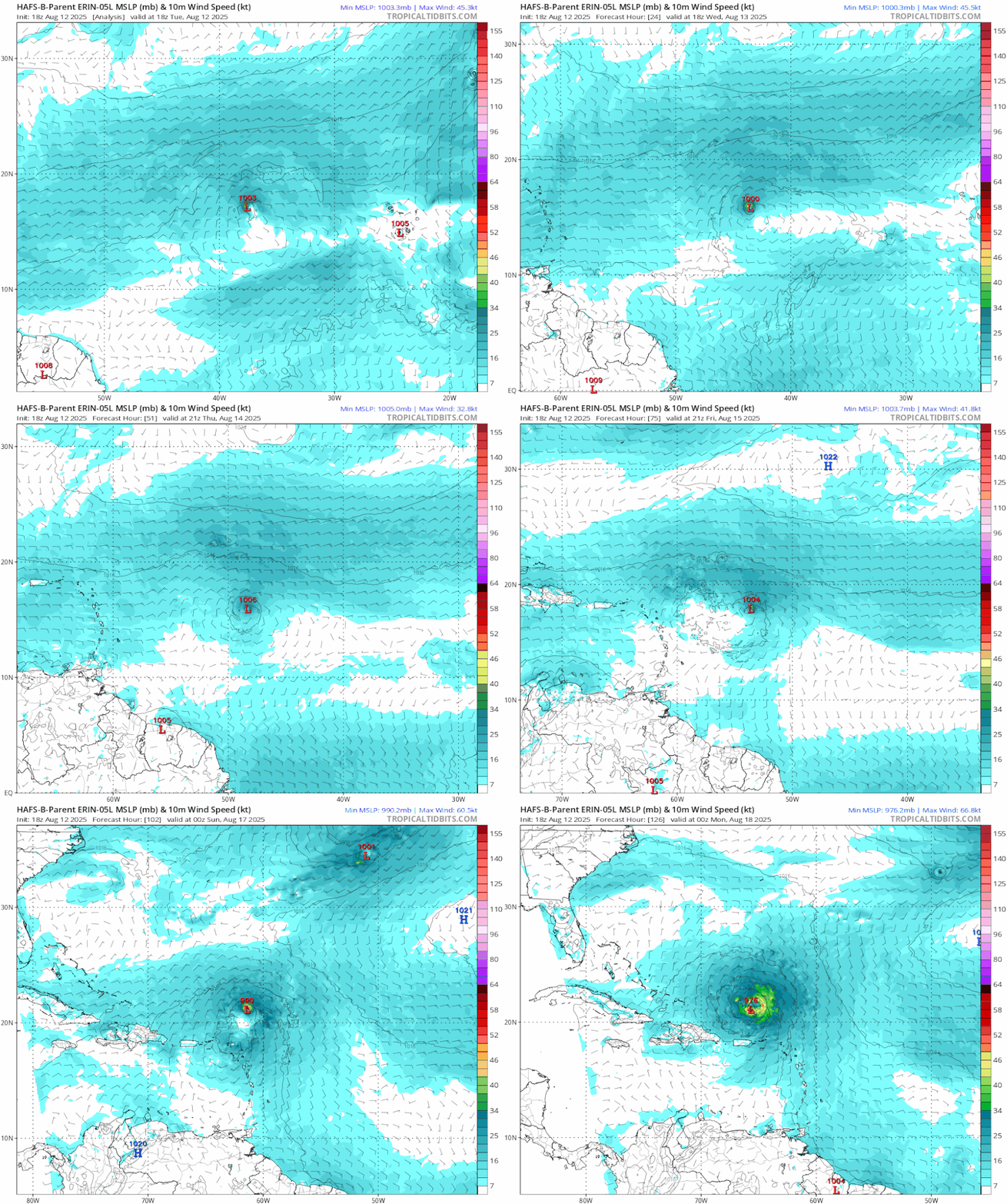
aspen wrote:18z HWRF initializes the anemic, spotty convective structure pretty well. It spends the next day or so building that up before starting RI by Friday morning.

The HAFS models have much worse initializations and keep this as a disorganized TS all the way past 60W.


I don't know how it gets much worse than the 12z hafs a which showed a 976mb hurricane for right now. One extreme to the other there.

18z HAFS-A gets down to about 15.4N then rockets nw. HAFS-B down to 15.3N -- 12z with the much stronger system, never got below 16N (18z GFS and 18z Icon briefly touches 16N, but that's about as far south as it gets -- Euro's southernmost extent is 16.2N) all somehow still miss the islands to the north despite it and through the invisible wall the GFS had around 64W.
4 likes   

User avatar
Teban54
Category 5
Category 5
Posts: 3269
Joined: Sat May 19, 2018 1:19 pm

Re: ATL: ERIN - Models

#302 Postby Teban54 » Tue Aug 12, 2025 8:07 pm

18z hurricane models, in 126 hours (00z 8/18):

  • HWRF: 955 mb, 104 kt, 21.7N 62.0W
  • HMON: 954 mb, 103 kt, 22.2N 62.9W
  • HAFS-A: 942 mb, 119 kt, 20.5N 65.6W
  • HAFS-B: 972 mb, 78 kt, 21.1N 65.7W

The two HAFS models still show a WSW dip that HWRF/HMON don't, which may explain the much more SW positions. Caveat: The hurricane models are usually pretty bad at track forecasts.

One possible reason for HAFS-B's very weak solution is that it seems to form another circulation west of Erin, which then does a Fujiwhara, as shown below. HAFS-A also shows a near due west movement in the last few frames while NNE of Puerto Rico, despite no Fujiwhara.

Image
4 likes   

User avatar
cycloneye
Admin
Admin
Posts: 146352
Age: 69
Joined: Thu Oct 10, 2002 10:54 am
Location: San Juan, Puerto Rico

Re: ATL: ERIN - Models

#303 Postby cycloneye » Tue Aug 12, 2025 8:16 pm

The 00z run of the spaghetti's for track and intensity.

Image

Image
0 likes   
Visit the Caribbean-Central America Weather Thread where you can find at first post web cams,radars
and observations from Caribbean basin members Click Here

redingtonbeach
Tropical Depression
Tropical Depression
Posts: 61
Joined: Mon Sep 04, 2017 12:05 am

Re: ATL: ERIN - Models

#304 Postby redingtonbeach » Tue Aug 12, 2025 9:01 pm

cycloneye wrote:The 00z run of the spaghetti's for track and intensity.


Hmmmm..

"The HAFS is NOAA’s next-generation multi-scale numerical mode..."

Hmmmm..

Sure looks to me like HAFS are still heading west...??

Hmmmm..
1 likes   

User avatar
Category5Kaiju
Category 5
Category 5
Posts: 4163
Joined: Thu Dec 24, 2020 12:45 pm
Location: Seattle

Re: ATL: ERIN - Models

#305 Postby Category5Kaiju » Tue Aug 12, 2025 9:13 pm

At this point, I think the models' unanimous agreement and settlement on a generic track indicate that Erin will curve northward at least just north of the Greater Antilles and highly likely won't be a CONUS threat. HOWEVER.....my bigger curiosity (and concern, in certain aspects) is whether this storm outright misses Bermuda or if it affects Bermuda.

Mind you, quite a few of the major operationals/ensembles had Erin getting uncomfortably close to Bermuda, and a few (such as the CMC or the GFS) explicitly featured runs that had Erin making a direct strike on the island. Also we need to keep in mind that this storm is likely going to expand its windfield upon embarking on its northward motion, reducing room for error in dodging Bermuda outright. As well as the projected increase in strength upon recurvature, helped in part due to the anomaously warm Sargasso Sea.

Praying that Bermuda will be ok, but as we've seen from storms such as Fabian and Nicole 2016, major hurricane strikes on Bermuda can happen from time to time, so something to be wary of.
3 likes   
Unless explicitly stated, all info in my posts is based on my own opinions and observations. Tropical storms and hurricanes can be extremely dangerous. Do not think you can beat Mother Nature. Refer to an accredited weather research agency or meteorologist if you need to make serious decisions regarding an approaching storm.

caneseddy
Category 5
Category 5
Posts: 1181
Joined: Fri Sep 03, 2004 9:31 pm
Location: Plantation, FL

Re: ATL: ERIN - Models

#306 Postby caneseddy » Tue Aug 12, 2025 9:55 pm

Interesting tidbit from the 11pm discussion regarding the GFS

There are no significant changes to
the long-range NHC forecast, and note that the 18Z GFS appeared to
be a significant outlier and was mostly disregarded in this package
2 likes   

Ian2401
Category 1
Category 1
Posts: 319
Joined: Thu Sep 14, 2017 5:55 pm
Location: Tallahassee, Florida
Contact:

Re: ATL: ERIN - Models

#307 Postby Ian2401 » Tue Aug 12, 2025 10:22 pm

That 18z HAFS-B run does some really wacky things at the end. It spits out - seemingly erroneously - an area of vorticity from the NW of the system that causes a downstream fujiwhara like interaction just north of the Leeward Islands. Anyone have any idea where this vorticity might be coming from?

Image
3 likes   
B.S. Meteorology from Florida State '24 // Current M.S. Meteorology student at Florida State

Research Interests: Rapid Intensification, TC Climatology, TC Modeling

Consult the NHC for official information

User avatar
REDHurricane
Category 1
Category 1
Posts: 415
Age: 28
Joined: Sun Jul 03, 2022 2:36 pm
Location: Northeast Pacific Ocean

Re: ATL: ERIN - Models

#308 Postby REDHurricane » Tue Aug 12, 2025 10:26 pm

Ian2401 wrote:That 18z HAFS-B run does some really wacky things at the end. It spits out - seemingly erroneously - an area of vorticity from the NW of the system that causes a downstream fujiwhara like interaction just north of the Leeward Islands. Anyone have any idea where this vorticity might be coming from?

https://i.imgur.com/Lt9KJSs.gif


The funding must have run out before the data could finish processing
2 likes   

BobHarlem
Category 5
Category 5
Posts: 2362
Joined: Thu Oct 20, 2005 6:11 pm

Re: ATL: ERIN - Models

#309 Postby BobHarlem » Tue Aug 12, 2025 10:37 pm

0z icon (left/sw of 12z)
Image
ridge situation:
Image
1 likes   

User avatar
ScottNAtlanta
Category 5
Category 5
Posts: 2428
Joined: Sat May 25, 2013 3:11 pm
Location: Atlanta, GA

Re: ATL: ERIN - Models

#310 Postby ScottNAtlanta » Tue Aug 12, 2025 10:54 pm

Ian2401 wrote:That 18z HAFS-B run does some really wacky things at the end. It spits out - seemingly erroneously - an area of vorticity from the NW of the system that causes a downstream fujiwhara like interaction just north of the Leeward Islands. Anyone have any idea where this vorticity might be coming from?

https://i.imgur.com/Lt9KJSs.gif

She ate him :hmm: :hmm:
2 likes   
The posts in this forum are NOT official forecast and should not be used as such. They are just the opinion of the poster and may or may not be backed by sound meteorological data. They are NOT endorsed by any professional institution or storm2k.org. For official information, please refer to the NHC and NWS products.

SconnieCane
Category 5
Category 5
Posts: 1007
Joined: Thu Aug 02, 2018 5:29 pm
Location: Madison, WI

Re: ATL: ERIN - Models

#311 Postby SconnieCane » Tue Aug 12, 2025 10:58 pm


Also gets it down to 929 mb. :eek:

Didn't the ICON do pretty well with some of the Atlantic TCs last year, moreso than expected by most observers (myself included)?
0 likes   

LarryWx
S2K Supporter
S2K Supporter
Posts: 6508
Joined: Sun Sep 07, 2003 2:04 pm
Location: GA

Re: ATL: ERIN - Models

#312 Postby LarryWx » Tue Aug 12, 2025 11:25 pm

0Z UKMET: recurves safely from Conus but further W at 70.3+…this would be good news for Bermuda

TROPICAL STORM ERIN ANALYSED POSITION : 16.4N 39.2W

ATCF IDENTIFIER : AL052025

LEAD CENTRAL MAXIMUM WIND
VERIFYING TIME TIME POSITION PRESSURE (MB) SPEED (KNOTS)
-------------- ---- -------- ------------- -------------
0000UTC 13.08.2025 0 16.4N 39.2W 1008 31
1200UTC 13.08.2025 12 15.8N 41.9W 1008 27
0000UTC 14.08.2025 24 15.9N 44.1W 1008 27
1200UTC 14.08.2025 36 16.8N 47.1W 1008 28
0000UTC 15.08.2025 48 18.0N 50.2W 1009 30
1200UTC 15.08.2025 60 19.0N 53.8W 1007 32
0000UTC 16.08.2025 72 19.7N 57.3W 1005 31
1200UTC 16.08.2025 84 20.3N 60.3W 1003 33
0000UTC 17.08.2025 96 21.0N 62.9W 1001 38
1200UTC 17.08.2025 108 21.7N 65.6W 999 45
0000UTC 18.08.2025 120 22.7N 67.2W 998 43
1200UTC 18.08.2025 132 24.5N 68.3W 996 45
0000UTC 19.08.2025 144 26.6N 69.4W 993 49
1200UTC 19.08.2025 156 28.6N 70.1W 989 48
0000UTC 20.08.2025 168 30.7N 70.3W 984 49
0 likes   
Personal Forecast Disclaimer:
The posts in this forum are NOT official forecasts and should not be used as such. They are just the opinion of the poster and may or may not be backed by sound meteorological data. They are NOT endorsed by any professional institution or storm2k.org. For official information, please refer to the NHC and NWS products.

LarryWx
S2K Supporter
S2K Supporter
Posts: 6508
Joined: Sun Sep 07, 2003 2:04 pm
Location: GA

Re: ATL: ERIN - Models

#313 Postby LarryWx » Tue Aug 12, 2025 11:40 pm

The 0Z GFS and CMC are both very close to Bermuda.
0 likes   
Personal Forecast Disclaimer:
The posts in this forum are NOT official forecasts and should not be used as such. They are just the opinion of the poster and may or may not be backed by sound meteorological data. They are NOT endorsed by any professional institution or storm2k.org. For official information, please refer to the NHC and NWS products.

User avatar
kevin
Category 5
Category 5
Posts: 2658
Age: 26
Joined: Wed Aug 28, 2019 4:35 am

Re: ATL: ERIN - Models

#314 Postby kevin » Tue Aug 12, 2025 11:52 pm

The 00z ICON is still a bit worrisome for the US, but in general I'd say that chances of a CONUS impact are becoming minimal with recent model trends. The main danger now is for Bermuda.
0 likes   

LarryWx
S2K Supporter
S2K Supporter
Posts: 6508
Joined: Sun Sep 07, 2003 2:04 pm
Location: GA

Re: ATL: ERIN - Models

#315 Postby LarryWx » Wed Aug 13, 2025 12:48 am

0Z Euro avoids all land in the W basin with it going ~250 miles W of Bermuda.
0 likes   
Personal Forecast Disclaimer:
The posts in this forum are NOT official forecasts and should not be used as such. They are just the opinion of the poster and may or may not be backed by sound meteorological data. They are NOT endorsed by any professional institution or storm2k.org. For official information, please refer to the NHC and NWS products.

DunedinDave
Category 1
Category 1
Posts: 254
Joined: Fri Aug 25, 2023 10:31 am

Re: ATL: ERIN - Models

#316 Postby DunedinDave » Wed Aug 13, 2025 1:14 am

Euro 0z—System behind Erin goes through Cuba and then reforms into strong TS and rides Fla west coast up to panhandle.
0 likes   

LarryWx
S2K Supporter
S2K Supporter
Posts: 6508
Joined: Sun Sep 07, 2003 2:04 pm
Location: GA

Re: ATL: ERIN - Models

#317 Postby LarryWx » Wed Aug 13, 2025 1:37 am

DunedinDave wrote:Euro 0z—System behind Erin goes through Cuba and then reforms into strong TS and rides Fla west coast up to panhandle.


Do you mean 0Z Euro AI version?
0 likes   
Personal Forecast Disclaimer:
The posts in this forum are NOT official forecasts and should not be used as such. They are just the opinion of the poster and may or may not be backed by sound meteorological data. They are NOT endorsed by any professional institution or storm2k.org. For official information, please refer to the NHC and NWS products.

User avatar
chaser1
S2K Supporter
S2K Supporter
Posts: 5520
Age: 64
Joined: Sat Oct 15, 2005 5:59 pm
Location: Longwood, Fl

Re: ATL: ERIN - Models

#318 Postby chaser1 » Wed Aug 13, 2025 2:11 am

DunedinDave wrote:Euro 0z—System behind Erin goes through Cuba and then reforms into strong TS and rides Fla west coast up to panhandle.


I am slightly suspicous of that forecast verifying. Erin's origin and early disturbance track suggests to me that in the near term, there could well be additional tropical waves that will also emerge off the African continent at a similar latitude. That alone would lead me to think that additional tear-term disturbances will be apt to quickly recurve rather then quietly track westward across the basin. Of course there could well be further south weak impulses traversing through the ITCZ without significant development or organization that could eventually move into a more favorable region west of 60 or 70W, but that doesn't sound like the type of system you indicated that the EURO depicts.
0 likes   
Andy D

(For official information, please refer to the NHC and NWS products.)

User avatar
kevin
Category 5
Category 5
Posts: 2658
Age: 26
Joined: Wed Aug 28, 2019 4:35 am

Re: ATL: ERIN - Models

#319 Postby kevin » Wed Aug 13, 2025 3:25 am

As I also did multiple times for other storms in past years, I've made a combined overview of the 4 hurricane models (HWRF, HMON, HAFS-A, HAFS-B). Here I combined the pressure and intensity estimates of Erin every 6 hours and made a weighted average of the four models. I also added the weighted average latitude and longitude every 18 hours.

00z, August 13, hurricane model blend, Erin

--- Model peak intensity ---
HWRF = 946mb/107kt
HMON = 959mb/118kt
HAFS-A = 933mb/117kt
HAFS-B = 925mb/129kt

--- Hurricane model blend ---

The hurricane models show Erin fluctuating in strength over the next 40ish hours. HAFS-B shows rapid strengthening to a hurricane before collapsing again, while other models show steady organization with some minor fluctuations. This uncertainty is to be expected due to the fragile nature of Erin at the moment. After this period, Erin is expected to strengthen into a hurricane and continue intensifying into a major hurricane just 30 hours after that. All hurricane models are in agreement on that with surprising similarity over the time period +42 to +102 hours. The last 20 hours of the forecast are more tricky as the models do not agree on Erin's ceiling. HWRF and HMON show a more struggling Erin which peaks around 105 kt for HWRF with an unstable core and a very brief 118 kt peak in the HMON run before a collapse to 80 kt. On the contrary, HAFS-A and HAFS-B show a much more stable major hurricane which continues to strengthen into a category 4 hurricane and even reaches 920s mb values in the HAFS-B run. All in all, while there is solid agreement on Erin becoming a major hurricane, its ceiling is more uncertain with anything in the range of 960mb/100kt to 930mb/125kt being realistic. The blend peaks as a high-end category 3 hurricane near the end of the run. In terms of track the hurricane models do not deviate significantly from the NHC forecast and ends within roughly 50 miles of the official forecast.

Blend
PEAK: 942 mb @ 126 hrs | 111 kt @ 114 hrs
ACE (0 - 126 hrs) = 14.0
Time (hr) / Pressure (mb) / Wind (kt) / Location (lat, lon [deg])
00 / 1003 / 43 / 16.8N, 39.3W
06 / 999 / 45
12 / 999 / 51
18 / 997 / 51 / 16.1N, 43.9W
24 / 995 / 56
30 / 995 / 52
36 / 997 / 51 / 16.3N, 48.0W
42 / 995 / 50
48 / 991 / 58
54 / 986 / 65 / 17.3N, 51.9W - C1
60 / 983 / 73
66 / 981 / 76
72 / 976 / 86 / 18.8N, 56.2W - C2
78 / 971 / 91
84 / 966 / 97 - C3
90 / 962 / 100 / 19.9N, 60.2W
96 / 962 / 103
102 / 957 / 104
108 / 950 / 105 / 21.0N, 63.2W
114 / 947 / 111
120 / 945 / 108
126 / 942 / 105 / 22.9N, 65.9W

--- Previous blend analyses ---

None yet
5 likes   

User avatar
kevin
Category 5
Category 5
Posts: 2658
Age: 26
Joined: Wed Aug 28, 2019 4:35 am

Re: ATL: ERIN - Models

#320 Postby kevin » Wed Aug 13, 2025 5:44 am

06z GFS, direct MH landfall on Bermuda.

Image
0 likes   


Return to “2025”

Who is online

Users browsing this forum: hipshot and 31 guests