NATL: MELISSA - Models
Moderators: hurricanetrack, S2k Moderators

The posts in this forum are NOT official forecasts and should not be used as such. They are just the opinion of the poster and may or may not be backed by sound meteorological data. They are NOT endorsed by any professional institution or STORM2K. For official information, please refer to products from the National Hurricane Center and National Weather Service.


Re: NATL: MELISSA - Models
18Z Euro gives much of Jamaica near or just over 20” qpf with heavy rain still likely continuing for a few more hours with the storm then still centered over SW Jamaica; SLP is then way down at 943 mb with it moving slowly NNE while SSE of a strong upper trough that’s then over the E US.
0 likes
Personal Forecast Disclaimer:
The posts in this forum are NOT official forecasts and should not be used as such. They are just the opinion of the poster and may or may not be backed by sound meteorological data. They are NOT endorsed by any professional institution or storm2k.org. For official information, please refer to the NHC and NWS products.
The posts in this forum are NOT official forecasts and should not be used as such. They are just the opinion of the poster and may or may not be backed by sound meteorological data. They are NOT endorsed by any professional institution or storm2k.org. For official information, please refer to the NHC and NWS products.
-
Hypercane_Kyle

- Category 5

- Posts: 3408
- Joined: Sat Mar 07, 2015 7:58 pm
- Location: Cape Canaveral, FL
Re: NATL: MELISSA - Models
SouthFLTropics wrote:18z HAFS-B has so far backed off significantly from the earlier insane 12z run.
18z HAFS-A, however, is actually slightly stronger.
2 likes
My posts are my own personal opinion, defer to the National Hurricane Center (NHC) and other NOAA products for decision making during hurricane season.
Re: NATL: MELISSA - Models
18Z GEFS: though it still has majority to W of Hispaniola, it is a smaller majority than the last 3 runs with it closer to 2/3 of the members there
0 likes
Personal Forecast Disclaimer:
The posts in this forum are NOT official forecasts and should not be used as such. They are just the opinion of the poster and may or may not be backed by sound meteorological data. They are NOT endorsed by any professional institution or storm2k.org. For official information, please refer to the NHC and NWS products.
The posts in this forum are NOT official forecasts and should not be used as such. They are just the opinion of the poster and may or may not be backed by sound meteorological data. They are NOT endorsed by any professional institution or storm2k.org. For official information, please refer to the NHC and NWS products.
-
AutoPenalti
- Category 5
- Posts: 4090
- Age: 29
- Joined: Mon Aug 17, 2015 4:16 pm
- Location: Ft. Lauderdale, Florida
Re: NATL: MELISSA - Models
18z Euro shifts east at 144.
0 likes
The posts in this forum are NOT official forecasts and should not be used as such. They are just the opinion of the poster and may or may not be backed by sound meteorological data. They are NOT endorsed by any professional institution or STORM2K. For official information, please refer to products from the NHC and NWS.
Model Runs Cheat Sheet:
GFS (5:30 AM/PM, 11:30 AM/PM)
HWRF, GFDL, UKMET, NAVGEM (6:30-8:00 AM/PM, 12:30-2:00 AM/PM)
ECMWF (1:45 AM/PM)
TCVN is a weighted averaged

Re: NATL: MELISSA - Models
AutoPenalti wrote:18z Euro shifts east at 144.
Everything is shifting eastward for 18z after several cycles of west shifts. The wipers are wiping...
0 likes
Andrew (1992), Irene (1999), Frances (2004), Katrina (2005), Wilma (2005), Fay (2008), Irma (2017), Eta (2020), Ian (2022)

Re: NATL: MELISSA - Models
Nuno wrote:AutoPenalti wrote:18z Euro shifts east at 144.
Everything is shifting eastward for 18z after several cycles of west shifts. The wipers are wiping...
This whole 18z suite was odd. Hurricane models also shifted a little east, and the HAFS-B weirdly lost the center for a bit.
0 likes
Irene '11 Sandy '12 Hermine '16 5/15/2018 Derecho Fay '20 Isaias '20 Elsa '21 Henri '21 Ida '21
I am only a meteorology enthusiast who knows a decent amount about tropical cyclones. Look to the professional mets, the NHC, or your local weather office for the best information.
I am only a meteorology enthusiast who knows a decent amount about tropical cyclones. Look to the professional mets, the NHC, or your local weather office for the best information.

Re: NATL: MELISSA - Models
I'm curious whether that might be a result of the next short wave dropping in slightly quicker, or perhaps a slight change in the orientation of its tilt?
0 likes
Andy D
(For official information, please refer to the NHC and NWS products.)
(For official information, please refer to the NHC and NWS products.)

Re: NATL: MELISSA - Models
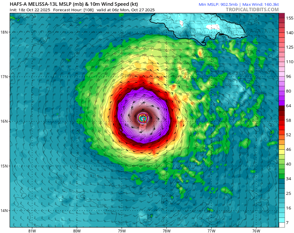
Hypercane_Kyle wrote:SouthFLTropics wrote:18z HAFS-B has so far backed off significantly from the earlier insane 12z run.
18z HAFS-A, however, is actually slightly stronger.
18z HAFS-A is actually the strongest in wind speed among all past runs, by a substantial margin. It has 160 kts, when earlier runs "only" had 150 kts or less.
0 likes
-
CrazyC83
- Professional-Met

- Posts: 34138
- Joined: Tue Mar 07, 2006 11:57 pm
- Location: Deep South, for the first time!
Re: NATL: MELISSA - Models
How does the upper level environment compare to the reanalyzed environment from the 1932 hurricane? Since that seems to be the primary analog right now.
2 likes
-
SouthFLTropics

- Category 5
- Posts: 4258
- Age: 50
- Joined: Thu Aug 14, 2003 8:04 am
- Location: Port St. Lucie, Florida
Re: NATL: MELISSA - Models
00z CMC, WHAT ARE YOU DOING??? That’s a little too close to South Florida!!!
Sent from my iPhone using Tapatalk
Sent from my iPhone using Tapatalk
1 likes
Fourth Generation Florida Native
Personal Storm History: David 79, Andrew 92, Erin 95, Floyd 99, Irene 99, Frances 04, Jeanne 04, Wilma 05, Matthew 16, Irma 17, Ian 22, Nicole 22, Milton 24
Personal Storm History: David 79, Andrew 92, Erin 95, Floyd 99, Irene 99, Frances 04, Jeanne 04, Wilma 05, Matthew 16, Irma 17, Ian 22, Nicole 22, Milton 24
-
Tekken_Guy
- Tropical Storm

- Posts: 140
- Joined: Fri Sep 01, 2017 8:08 pm
Re: NATL: MELISSA - Models
SouthFLTropics wrote:00z CMC, WHAT ARE YOU DOING??? That’s a little too close to South Florida!!!
Sent from my iPhone using Tapatalk
Well hopefully it won’t be heading to Jersey this time.
0 likes
Re: NATL: MELISSA - Models
0Z UKMET: still weak but now even further N, doesn’t go as far W, and even turns NNE at the end
GLOBAL MODEL DATA TIME 0000UTC 23.10.2025
TROPICAL STORM MELISSA ANALYSED POSITION : 14.5N 75.0W
ATCF IDENTIFIER : AL132025
LEAD CENTRAL MAXIMUM WIND
VERIFYING TIME TIME POSITION PRESSURE (MB) SPEED (KNOTS)
-------------- ---- -------- ------------- -------------
0000UTC 23.10.2025 0 14.5N 75.0W 1005 33
1200UTC 23.10.2025 12 14.9N 74.5W 1005 33
0000UTC 24.10.2025 24 16.0N 75.2W 1004 34
1200UTC 24.10.2025 36 16.1N 74.8W 1004 30
0000UTC 25.10.2025 48 16.6N 74.3W 1004 34
1200UTC 25.10.2025 60 16.7N 74.8W 1005 30
0000UTC 26.10.2025 72 16.9N 74.8W 1004 30
1200UTC 26.10.2025 84 17.1N 75.7W 1005 29
0000UTC 27.10.2025 96 17.5N 78.0W 1005 26
1200UTC 27.10.2025 108 17.0N 78.6W 1005 24
0000UTC 28.10.2025 120 17.6N 79.5W 1004 24
1200UTC 28.10.2025 132 17.9N 80.9W 1005 24
0000UTC 29.10.2025 144 17.9N 82.2W 1005 23
1200UTC 29.10.2025 156 18.7N 82.9W 1005 25
0000UTC 30.10.2025 168 19.5N 82.5W 1004 28
0 likes
Personal Forecast Disclaimer:
The posts in this forum are NOT official forecasts and should not be used as such. They are just the opinion of the poster and may or may not be backed by sound meteorological data. They are NOT endorsed by any professional institution or storm2k.org. For official information, please refer to the NHC and NWS products.
The posts in this forum are NOT official forecasts and should not be used as such. They are just the opinion of the poster and may or may not be backed by sound meteorological data. They are NOT endorsed by any professional institution or storm2k.org. For official information, please refer to the NHC and NWS products.

Re: NATL: MELISSA - Models
CrazyC83 wrote:How does the upper level environment compare to the reanalyzed environment from the 1932 hurricane? Since that seems to be the primary analog right now.
1932 certainly comes to mind. Also a Michelle 2001, but on crack. Would be nice to know indeed how similar the upper environment it is to 1932.

0 likes
Georges '98, Irene '99, Frances '04, Jeanne '04, Katrina '05, Wilma '05, Gustav '08, Isaac '12, Matthew '16, Florence '18, Michael '18, Ian '22
Return to “Active Storms/Invests - Atlantic/EastPAC/CentralPAC/MED”
Who is online
Users browsing this forum: No registered users and 98 guests