Dennis seems a bit surprised on the effects and he downplays tornados even ef-0.MetroMike wrote:Local Met Denis Phillips said possible record storm surge numbers have come in for Pinellas Co.
Up to 10ft surge.Will get very rough this evening here.
ATL: HELENE - Post-Tropical - Discussion
Moderator: S2k Moderators
-
jlauderdal
- S2K Supporter

- Posts: 7240
- Joined: Wed May 19, 2004 5:46 am
- Location: NE Fort Lauderdale
- Contact:
Re: ATL: HELENE - Hurricane - Discussion
0 likes
-
cheezyWXguy

- Category 5

- Posts: 6280
- Joined: Mon Feb 13, 2006 12:29 am
- Location: Dallas, TX
Re: ATL: HELENE - Hurricane - Discussion
Kazmit wrote:Special advisory coming soon?
Lol a special advisory to announce cat4 upgrade 9 minutes after your previous advisory reducing the winds. Oof. Wouldn’t be the best optics if they had to do that.
Last edited by cheezyWXguy on Thu Sep 26, 2024 5:11 pm, edited 1 time in total.
5 likes
-
BrandonJay21
- S2K Supporter
- Posts: 17
- Joined: Tue Jun 04, 2013 7:51 pm
Re: ATL: HELENE - Hurricane - Discussion
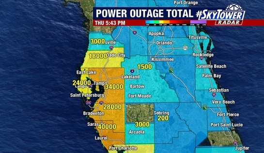
ConvergenceZone wrote:johngaltfla wrote:caneman wrote:43,000 without power in Tampa Bay
And climbing regionally.
https://johngaltfla.com/wp-content/uploads/2024/09/Screen-Shot-09-26-24-at-05.46-PM.jpg
does anyone know of a site where you can get a map like you show that shows updated power outages across the affected states?
Is this what you’re looking for? You can drill down into a county of a state.
https://poweroutage.us
1 likes

Re: ATL: HELENE - Hurricane - Discussion
The eye is tracking east of the NHC projected path again.
2 likes

Re: ATL: HELENE - Hurricane - Discussion
cheezyWXguy wrote:Kazmit wrote:Special advisory coming soon?
Lol a special advisory to announce cat4 upgrade 9 minutes after your previous advisory reducing the winds. Oof
As I've said earlier, the 6pm update initially had a typo and has been corrected back to 110 kt, just before the recon pass came in.
3 likes
TC naming lists: retirements and intensity
Most aggressive Advisory #1's in North Atlantic (cr. kevin for starting the list)
Most aggressive Advisory #1's in North Atlantic (cr. kevin for starting the list)
-
CrazyC83
- Professional-Met

- Posts: 34315
- Joined: Tue Mar 07, 2006 11:57 pm
- Location: Deep South, for the first time!
Re: ATL: HELENE - Hurricane - Discussion
I think NHC will just put out a Tropical Cyclone Update announcing the upgrade - 115 kt seems right, although a case could be made for 120 kt.
6 likes
-
ConvergenceZone
.gif)
- Category 5
- Posts: 5241
- Joined: Fri Jul 29, 2005 1:40 am
- Location: Northern California
Re: ATL: HELENE - Hurricane - Discussion
BrandonJay21 wrote:ConvergenceZone wrote:johngaltfla wrote:
And climbing regionally.
https://johngaltfla.com/wp-content/uploads/2024/09/Screen-Shot-09-26-24-at-05.46-PM.jpg
does anyone know of a site where you can get a map like you show that shows updated power outages across the affected states?
Is this what you’re looking for? You can drill down into a county of a state.
https://poweroutage.us
yea I found that also via google. but thank you. I'm good now.
1 likes
-
WaveBreaking

- Category 2

- Posts: 717
- Joined: Sun Jun 30, 2024 11:33 am
- Location: US
Re: ATL: HELENE - Hurricane - Discussion
It only took 12 hours for Helene to go from this

To this.

Never underestimate the Loop Current.
To this.
Never underestimate the Loop Current.
14 likes
I am NOT a professional meteorologist, so take all of my posts with a grain of salt. My opinions are mine and mine alone.
-
Bocadude85

- Category 5
- Posts: 2991
- Age: 39
- Joined: Mon Apr 18, 2005 2:20 pm
- Location: Honolulu,Hi
Re: ATL: HELENE - Hurricane - Discussion
ronjon wrote:The eye is tracking east of the NHC projected path again.
Yes it is, hopefully wobbles back or places like Cedar Key are going to be in even more trouble then they already are.
0 likes
-
Sciencerocks
- Category 5
- Posts: 10181
- Age: 40
- Joined: Thu Jul 06, 2017 1:51 am

-
ElectricStorm

- Category 5
- Posts: 5128
- Age: 25
- Joined: Tue Aug 13, 2019 11:23 pm
- Location: Norman, OK
Re: ATL: HELENE - Hurricane - Discussion
UW - CIMSS
ADVANCED DVORAK TECHNIQUE
ADT-Version 9.1
Tropical Cyclone Intensity Algorithm
----- Current Analysis -----
Date : 26 SEP 2024 Time : 214020 UTC
Lat : 27:45:36 N Lon : 84:25:48 W
CI# /Pressure/ Vmax
6.2 / 931.4mb/119.8kt
Final T# Adj T# Raw T#
6.2 6.4 6.8
Estimated radius of max. wind based on IR : 16 km
Center Temp : +0.7C Cloud Region Temp : -72.5C
Scene Type : EYE
5 likes
B.S Meteorology, University of Oklahoma '25
Please refer to the NHC, NWS, or SPC for official information.
Please refer to the NHC, NWS, or SPC for official information.
-
FLpanhandle91

- Category 5
- Posts: 1039
- Age: 34
- Joined: Mon Sep 13, 2010 3:50 pm
- Location: Fort Walton Beach, FL
Re: ATL: HELENE - Hurricane - Discussion
She will make a legitimate run at cat 5 in my opinion.
4 likes
Re: ATL: HELENE - Hurricane - Discussion
ElectricStorm wrote:UW - CIMSS
ADVANCED DVORAK TECHNIQUE
ADT-Version 9.1
Tropical Cyclone Intensity Algorithm
----- Current Analysis -----
Date : 26 SEP 2024 Time : 214020 UTC
Lat : 27:45:36 N Lon : 84:25:48 W
CI# /Pressure/ Vmax
6.2 / 931.4mb/119.8kt
Final T# Adj T# Raw T#
6.2 6.4 6.8
Estimated radius of max. wind based on IR : 16 km
Center Temp : +0.7C Cloud Region Temp : -72.5C
Scene Type : EYE
It's quite ironic that many people thought earlier that Helene had an anomalously low pressure for its wind speed (due to its size), and yet its pressure is now higher than satellite estimates.
3 likes
TC naming lists: retirements and intensity
Most aggressive Advisory #1's in North Atlantic (cr. kevin for starting the list)
Most aggressive Advisory #1's in North Atlantic (cr. kevin for starting the list)

Re: ATL: HELENE - Hurricane - Discussion
The breadth of the wind field continues to astound me, recon is just off the coast of Pinellas and recording 100kt FL wind:

2 likes
-
weeniepatrol

- Category 5
- Posts: 1339
- Joined: Sat Aug 22, 2020 5:30 pm
- Location: WA State
Re: ATL: HELENE - Hurricane - Discussion
...HELENE NOW AN EXTREMELY DANGEROUS CATEGORY 4 HURRICANE...
9 likes
Re: ATL: HELENE - Hurricane - Discussion
Officially 115 kt, 947 mb.
3 likes
TC naming lists: retirements and intensity
Most aggressive Advisory #1's in North Atlantic (cr. kevin for starting the list)
Most aggressive Advisory #1's in North Atlantic (cr. kevin for starting the list)

Re: ATL: HELENE - Hurricane - Discussion
There's the update statement. Category 4 with 130 mph and 947 mb.
4 likes
-
HurricaneAndre2008

- Category 1

- Posts: 356
- Age: 28
- Joined: Wed Jul 31, 2019 9:51 pm
- Contact:
Re: ATL: HELENE - Hurricane - Discussion
684
WTNT64 KNHC 262218
TCUAT4
Hurricane Helene Tropical Cyclone Update
NWS National Hurricane Center Miami FL AL092024
620 PM EDT Thu Sep 26 2024
...HELENE NOW AN EXTREMELY DANGEROUS CATEGORY 4 HURRICANE...
A NOAA Hurricane Hunter aircraft currently investigating Helene
recently found that the maximum sustained winds have increased to
130 mph (215 km/h). The minimum central pressure has also decreased
to 947 mb (27.96 inches) based on dropsonde data.
SUMMARY OF 620 PM EDT...2220 UTC...INFORMATION
----------------------------------------------
LOCATION...28.0N 84.5W
ABOUT 120 MI...195 KM W OF TAMPA FLORIDA
ABOUT 165 MI...265 KM S OF TALLAHASSEE FLORIDA
MAXIMUM SUSTAINED WINDS...130 MPH...215 KM/H
PRESENT MOVEMENT...NNE OR 25 DEGREES AT 23 MPH...37 KM/H
MINIMUM CENTRAL PRESSURE...947 MB...27.96 INCHES
$$
Forecaster Bucci/Pasch
0 likes
Cindy(2005), Katrina(2005), Rita(2005), Erin(2007), Isaac(2012)

Re: ATL: HELENE - Hurricane - Discussion
Undergoing explosive intensification, if we assume its at 947mb currently and the rate remains steady at 4 mb drop per hr, 3-4 hr to landfall gives us roughly 935mb at landfall. High tier.
The interm advisory 120 mph thing was obviously a typo, recon was showing EI before it came out with duel rotating hot towers and clearing eye on Sat.
The interm advisory 120 mph thing was obviously a typo, recon was showing EI before it came out with duel rotating hot towers and clearing eye on Sat.
4 likes

Re: ATL: HELENE - Hurricane - Discussion
caneman wrote:ronjon wrote:caneman wrote:
Probably but it's looked like Perry from the beginning.
I'm thinking between Perry and Steinhatchee. Definitely Taylor County. Euro, GFS, UK, ICON all zeroed in on a 20 mile strip of coast.
100% you, I and NDG were on it and maybe a few others. I've lived here since 1976. You kinda learn how these things behave minus the meteorology degree. Credit to Bay News 9 and Spectrum News they've been all over Perry area or Taylor county. Klystron is the real deal!
Maybe a few others. Give it up again for the Icon once again for a Gulf storm in 2024. It’s probably a Top 3 or 4 global these days - at least for the Gulf.
7 likes
Who is online
Users browsing this forum: No registered users and 5 guests