NATL: MELISSA - Models
Moderators: hurricanetrack, S2k Moderators

The posts in this forum are NOT official forecasts and should not be used as such. They are just the opinion of the poster and may or may not be backed by sound meteorological data. They are NOT endorsed by any professional institution or STORM2K. For official information, please refer to products from the National Hurricane Center and National Weather Service.


Re: NATL: MELISSA - Models
Really getting down to the wire for the GFS. I still think it will be a major bust, but time will tell.
0 likes
Igor 2010, Sandy 2012, Fay 2014, Gonzalo 2014, Joaquin 2015, Nicole 2016, Humberto 2019, Imelda 2025
I am only a tropical weather enthusiast. My predictions are not official and may or may not be backed by sound meteorological data. For official information, please refer to the NHC and NWS products.
I am only a tropical weather enthusiast. My predictions are not official and may or may not be backed by sound meteorological data. For official information, please refer to the NHC and NWS products.

Re: NATL: MELISSA - Models
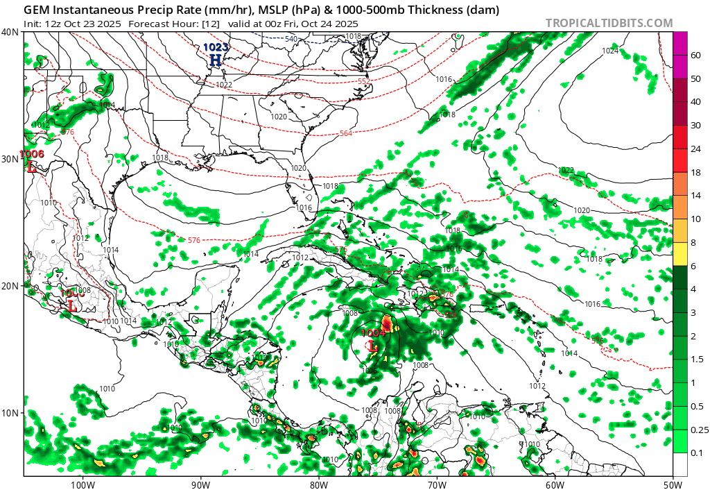
06z HWRF takes inspiration from the 00z HMON and flattens Jamaica.
With the increasing risk of a major — and potentially catastrophic — strike to the island, they really need to put it under Hurricane Watches. TS Watches are too conservative.
With the increasing risk of a major — and potentially catastrophic — strike to the island, they really need to put it under Hurricane Watches. TS Watches are too conservative.
0 likes
Irene '11 Sandy '12 Hermine '16 5/15/2018 Derecho Fay '20 Isaias '20 Elsa '21 Henri '21 Ida '21
I am only a meteorology enthusiast who knows a decent amount about tropical cyclones. Look to the professional mets, the NHC, or your local weather office for the best information.
I am only a meteorology enthusiast who knows a decent amount about tropical cyclones. Look to the professional mets, the NHC, or your local weather office for the best information.
Re: NATL: MELISSA - Models
Kazmit wrote:Really getting down to the wire for the GFS. I still think it will be a major bust, but time will tell.
Monday's equivalent 6z GFS had it landfalling on Haiti right now for what it's worth.
0 likes

Re: NATL: MELISSA - Models
aspen wrote:06z HWRF takes inspiration from the 00z HMON and flattens Jamaica.
With the increasing risk of a major — and potentially catastrophic — strike to the island, they really need to put it under Hurricane Watches. TS Watches are too conservative.
8am NHC update indicates hurricane watch now in effect for Jamaica.
...HURRICANE WATCH NOW IN EFFECT FOR JAMAICA...
...HEAVY RAINS AND LIFE-THREATENING FLOODING EXPECTED FOR PORTIONS
OF HISPANIOLA AND JAMAICA THROUGH THE WEEKEND...
SUMMARY OF 800 AM EDT...1200 UTC...INFORMATION
----------------------------------------------
LOCATION...15.5N 74.9W
ABOUT 215 MI...345 KM SE OF KINGSTON JAMAICA
ABOUT 275 MI...440 KM SW OF PORT AU PRINCE HAITI
MAXIMUM SUSTAINED WINDS...50 MPH...85 KM/H
PRESENT MOVEMENT...NW OR 310 DEGREES AT 5 MPH...7 KM/H
MINIMUM CENTRAL PRESSURE...1003 MB...29.62 INCHES
WATCHES AND WARNINGS
--------------------
CHANGES WITH THIS ADVISORY:
The government of Jamaica has issued a Hurricane Watch for the
island, and has upgraded the Tropical Storm Watch to a warning.
1 likes

Re: NATL: MELISSA - Models
06z GEFS is split in three main camps: 32% with a Haiti landfall, (2% going in between Haiti and Jamaica,) 30% with a Jamaica landfall and 35% going south of Jamaica. So basically we're still not a bit wiser.
0 likes
-
jlauderdal
- S2K Supporter

- Posts: 7232
- Joined: Wed May 19, 2004 5:46 am
- Location: NE Fort Lauderdale
- Contact:
Re: NATL: MELISSA - Models
Kazmit wrote:Really getting down to the wire for the GFS. I still think it will be a major bust, but time will tell.
Haiti would be under a hurricane warning right now if the gfs had it right. Google AI has been good and it's good to see AI having success. Will see how it goes next year but theoretically its should be better.
2 likes
Re: NATL: MELISSA - Models
I unfortunately didn't have time to write the last few blends, but I did keep track of them so you can see all blend intensity summaries at the bottom of this post.
06z, Oct/23/2026, hurricane model blend, Melissa
--- Model peak intensity ---
HWRF = 947mb/107kt
HMON = 948mb/113kt
HAFS-A = 910mb/139kt
HAFS-B = 917mb/137kt
--- Hurricane model blend ---
It's been 24 hours since the latest blend I wrote and, if anything, the situation is even more unclear now. Yesterday, it seemed like a pretty good consensus was forming for a track south and west of Jamaica. But then the Euro and some of the hurricane models started to trend NE towards Jamaica. On the other hand, ICON and GFS are now trending SE compared to their previous runs but are still on the eastern edge of the guidance.
Concerning the hurricane models, HWRF now shows a landfall on Jamaica followed by a turn north towards Cuba. HMON sits along the Jamaican coast for a while but eventually narrowly misses the island and turns north. HAFS-A and HAFS-B still put all their faith in a track south of Jamaica. Due to the Jamaica landfalls and land interaction the blend intensity is lower as of course HWRF & HMON weaken Melissa due to the landfall. HAFS-A and HAFS-B are a lot more erratic with their intensity near the end of the run with sudden changes back-and-forth of 10 mb and 20 - 30 kt and weird eye behavior. Maybe they are predicting EWRC shenanigans, but tbh I don't know what's going on. Let's see if it's still there in the 12z cycle. A blended average of the four models results in a direct Jamaica strike from the south. But note that two models go south of Jamaica, one goes barely above it and one hits it from the east. So none of the individual models show the track that the consensus shows. And on top of that the position uncertainty based on these four models at the timestamp of the Jamaica landfall is +/- 180 miles which makes it kinda useless.
Also note that the blend puts the current center at 14.5N/74.5W, while recon just found the center at 15.5N/74.9W so NW of the blend position. This big discrepancy north might make you think that the northern solutions are more reliable. However, HAFS-A and HAFS-B show by far the most northern tracks in the short-term and then go on to end way SW of HWRF & HMON later in the run. So this initial position doesn't immediately correlate with the future position. Furthermore, HMON and HAFS-A show a weird sudden increase to 60 - 65 kt within 6 hours which results in very (let's call it) 'unique' center relocations. I honestly don't think this is realistic at all. I know I'm writing a multi-paragraph piece right now but in my opinion this whole model cycle is unusual and should be taken with a big pinch of salt. So, bottom line = everything is still possible and nobody knows for sure. Haiti might still be in play and Jamaica is definitely in play.
Blend
PEAK: 937 mb @ 126 hrs | 111 kt @ 126 hrs
ACE (0 - 126 hrs) = 13.0
Time (hr) / Pressure (mb) / Wind (kt) / Location (lat, lon [deg])
00 / 999 / 45 / 14.5N, 74.5W
06 / 998 / 51
12 / 997 / 50
18 / 998 / 42 / 14.9N, 74.7W
24 / 999 / 42
30 / 1000 / 42
36 / 996 / 49 / 16.3N, 74.2W
42 / 993 / 48
48 / 992 / 46
54 / 991 / 54 / 17.0N, 74.8W
60 / 986 / 64
66 / 980 / 72 - C1
72 / 977 / 73 / 17.3N, 75.7W
78 / 974 / 76
84 / 960 / 93 - C2
90 / 957 / 100 / 17.6N, 76.9W - C3
96 / 948 / 110
102 / 941 / 106
108 / 937 / 103 / 17.7N, 77.5W
114 / 939 / 102
120 / 940 / 109
126 / 937 / 111 / 18.6N, 76.6W
--- Previous blend analyses ---
00z, Oct 23 = 918mb/130kt
18z, Oct 22 = 929mb/125kt
12z, Oct 22 = 920mb/127kt
06z, Oct 22 = 920mb/127kt
00z, Oct 22 = 911mb/134kt
Forecast track (weighted average of the hurricane model tracks)
6 likes
Re: NATL: MELISSA - Models
The 06z Euro ensemble also keeps believing in its own solution and even has a few CA landfalls.
*6% Haiti landfall (3/51)
*6% Between Haiti and Jamaica (3/51)
*16% Jamaica landfall (8/51)
*72% South of Jamaica (37/51)

*6% Haiti landfall (3/51)
*6% Between Haiti and Jamaica (3/51)
*16% Jamaica landfall (8/51)
*72% South of Jamaica (37/51)
3 likes
-
cycloneye

- Admin

- Posts: 147941
- Age: 69
- Joined: Thu Oct 10, 2002 10:54 am
- Location: San Juan, Puerto Rico
Re: NATL: MELISSA - Models
2 likes
Visit the Caribbean-Central America Weather Thread where you can find at first post web cams,radars
and observations from Caribbean basin members Click Here
and observations from Caribbean basin members Click Here
-
wzrgirl1

- S2K Supporter
- Posts: 1360
- Joined: Sat Sep 04, 2004 6:44 am
- Location: Pembroke Pines, Florida
Re: NATL: MELISSA - Models

0 likes
-
Blown Away

- S2K Supporter
- Posts: 10219
- Joined: Wed May 26, 2004 6:17 am
Re: NATL: MELISSA - Models
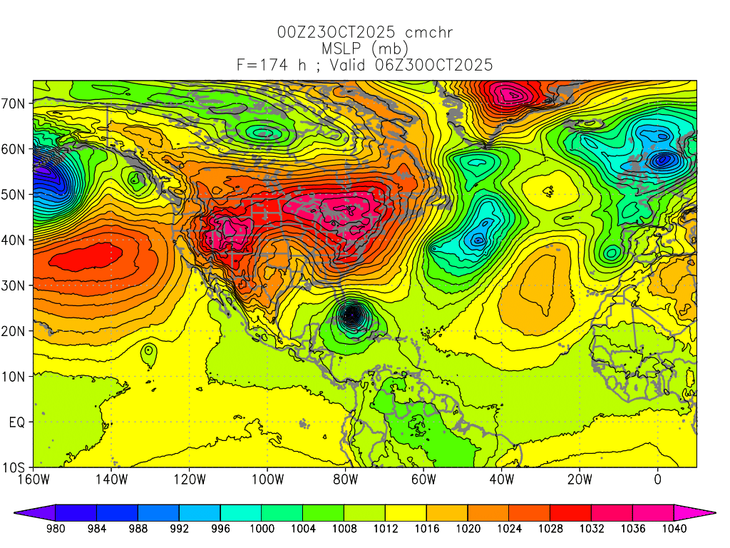
wzrgirl1 wrote:http://moe.met.fsu.edu/tcgengifs/cmchr/2025102300/slp29.png
Can someone explain this to me please?
Another view of the 12z CMC (Canadian) model run that continues to show Melissa moving NE passing just SE of Florida. It's the W outlier.
3 likes
Hurricane Eye Experience: David 79, Irene 99, Frances 04, Jeanne 04, Wilma 05… Hurricane Brush Experience: Andrew 92, Erin 95, Floyd 99, Matthew 16, Irma 17, Ian 22, Nicole 22…
-
Blown Away
- S2K Supporter
- Posts: 10219
- Joined: Wed May 26, 2004 6:17 am
Re: NATL: MELISSA - Models
kevin wrote:The 06z Euro ensemble also keeps believing in its own solution and even has a few CA landfalls.
*6% Haiti landfall (3/51)
*6% Between Haiti and Jamaica (3/51)
*16% Jamaica landfall (8/51)
*72% South of Jamaica (37/51)
https://i.imgur.com/jvHYg94.png
Wow, that's a decent shift WSW and I think the trend will continue that way. JMHO
1 likes
Hurricane Eye Experience: David 79, Irene 99, Frances 04, Jeanne 04, Wilma 05… Hurricane Brush Experience: Andrew 92, Erin 95, Floyd 99, Matthew 16, Irma 17, Ian 22, Nicole 22…


Re: NATL: MELISSA - Models
12z hurricane models are running now. Curious to see whether or not this round (of the HAFS especially) confirms a general downward trend in the intensity forecast or bounces back to something like of yesterday's crazier solutions. The models should oscillate less as we get closer to the period when RI is actually expected to start.
3 likes
-
WaveBreaking

- Category 2

- Posts: 643
- Joined: Sun Jun 30, 2024 11:33 am
- Location: US
Re: NATL: MELISSA - Models
sasha_B wrote:12z hurricane models are running now. Curious to see whether or not this round (of the HAFS especially) confirms a general downward trend in the intensity forecast or bounces back to something like of yesterday's crazier solutions. The models should oscillate less as we get closer to the period when RI is actually expected to start.
Both HAFS models have shifted south and trended stronger (the 998 mbar isobar is slightly larger in the 12Z HAFS-A run) in the short term in the 12Z runs, with the 12Z HAFS-B being an entire degree south of the 06Z run.


1 likes
I am NOT a professional meteorologist, so take all of my posts with a grain of salt. My opinions are mine and mine alone.
-
WaveBreaking
- Category 2
- Posts: 643
- Joined: Sun Jun 30, 2024 11:33 am
- Location: US
Re: NATL: MELISSA - Models
Significant uptrend on intensity in the HAFS-B. Both models have Melissa moving very slowly nearly due W around this time.


2 likes
I am NOT a professional meteorologist, so take all of my posts with a grain of salt. My opinions are mine and mine alone.
Re: NATL: MELISSA - Models
Blown Away wrote:wzrgirl1 wrote:http://moe.met.fsu.edu/tcgengifs/cmchr/2025102300/slp29.png
Can someone explain this to me please?
[url]https://i.postimg.cc/YqrYNtpq/gem-mslp-pcpn-watl-fh12-192.gif [/url]
Another view of the 12z CMC (Canadian) model run that continues to show Melissa moving NE passing just SE of Florida. It's the W outlier.
12z UK Met is also a little further west than that (And still ultra weak)
0 likes
Re: NATL: MELISSA - Models
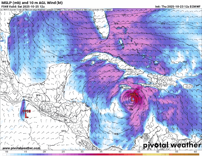
Looks like HAFS-B is showing a landfall or very close brush with the east coast of Jamaica as a 145 kt / 915 hPa Cat 5 @ +75h (15z Sunday), with pressure rising and wind dropping off slightly in the next frame due to land interaction. Hardly good news for Jamaica but I expect that that interaction would put a lower ceiling on any potential secondary peak thereafter.
EDIT: This is followed by a second & possibly a third landfall as a large but weakening high-end Cat 4 (125~135 kt / 920 hPa) along the southern coast on Monday morning, after briefly regaining Cat 5 winds offshore during the overnight hours. Really an alarming scenario; as was noted in the discussions thread, I don't think Jamaica has seen a landfall with surface pressures like that.
EDIT: This is followed by a second & possibly a third landfall as a large but weakening high-end Cat 4 (125~135 kt / 920 hPa) along the southern coast on Monday morning, after briefly regaining Cat 5 winds offshore during the overnight hours. Really an alarming scenario; as was noted in the discussions thread, I don't think Jamaica has seen a landfall with surface pressures like that.
4 likes

Re: NATL: MELISSA - Models
The 12z HAFS-B would be a terrible flooding scenario for Kingston, sitting just offshore with the NE quadrant pushing water up the bay for 24+ hours. I'm not sure what the bathymetry looks like in the area but that would have to cause some severe storm surge on top of the fresh water flooding coming down from the mountains, possibly the worst-case outcome for Melissa outside of Hispaniola.
2 likes

Re: RE: Re: NATL: MELISSA - Models
That would pretty much be the worst case scenario for Jamaica. A Cat 4/5 hurricane stalling over your population center would be devastating. Let's pray this outcome will not happen as I can't imagine they would ever recover from that.Travorum wrote:The 12z HAFS-B would be a terrible flooding scenario for Kingston, sitting just offshore with the NE quadrant pushing water up the bay for 24+ hours. I'm not sure what the bathymetry looks like in the area but that would have to cause some severe storm surge on top of the fresh water flooding coming down from the mountains, possibly the worst-case outcome for Melissa outside of Hispaniola.
3 likes
Re: NATL: MELISSA - Models
12z euro puts a cat 4/5 into the western edge of Jamaica, meaning the right front quad is pounding most of the entire island. Long duration Impacts from late Sunday until late Wednesday. East of center would have the double whammy of flooding rains coming down from the mountains while storm surge brings up the ocean level. Those in Jamaica need to prepare now, and take a LOT of before photos.

Last edited by BobHarlem on Thu Oct 23, 2025 2:19 pm, edited 2 times in total.
3 likes
Return to “Active Storms/Invests - Atlantic/EastPAC/CentralPAC/MED”
Who is online
Users browsing this forum: No registered users and 104 guests