NATL: MELISSA - Tropical Storm - Discussion
Moderators: hurricanetrack, S2k Moderators

The posts in this forum are NOT official forecasts and should not be used as such. They are just the opinion of the poster and may or may not be backed by sound meteorological data. They are NOT endorsed by any professional institution or STORM2K. For official information, please refer to products from the National Hurricane Center and National Weather Service.

-
Hurricane2022

- Category 5

- Posts: 1764
- Joined: Tue Aug 23, 2022 11:38 pm
- Location: Araçatuba, Brazil
Re: NATL: MELISSA - Tropical Storm - Discussion
If Melissa stays weaker in the next 36 - 48 hours, it's possible that she can miss Jamaica and start to track WSW/W over the WCAR?
Last edited by Hurricane2022 on Thu Oct 23, 2025 7:57 pm, edited 1 time in total.
0 likes
Sorry for the bad English sometimes...!
For reliable and detailed information for any meteorological phenomenon, please consult the National Hurricane Center, Joint Typhoon Warning Center , or your local Meteo Center.
--------
ECCE OMNIA NOVA FACIAM (Ap 21,5).
For reliable and detailed information for any meteorological phenomenon, please consult the National Hurricane Center, Joint Typhoon Warning Center , or your local Meteo Center.
--------
ECCE OMNIA NOVA FACIAM (Ap 21,5).

Re: NATL: MELISSA - Tropical Storm - Discussion
Hurricane2022 wrote:If Melissa stays weaker in the next 36 - 48 hours, it's possinle that she can miss Jamaica and start to track WSW/W over the WCAR?
More likely she continues to drift north a little more then gets pulled back W or WSW over Jamaica as the Gulf ridging takes over steering.
Lots of possibilities though.
https://www.tropicaltidbits.com/
1 likes
-
Hypercane_Kyle

- Category 5
- Posts: 3409
- Joined: Sat Mar 07, 2015 7:58 pm
- Location: Cape Canaveral, FL
Re: NATL: MELISSA - Tropical Storm - Discussion
Shear beginning to lessen and an inner core is finally starting to develop. I think Melissa may make its run for hurricane status tomorrow afternoon, setting the stage for explosive RI beginning Saturday morning.

4 likes
My posts are my own personal opinion, defer to the National Hurricane Center (NHC) and other NOAA products for decision making during hurricane season.
-
Category5Kaiju

- Category 5
- Posts: 4231
- Joined: Thu Dec 24, 2020 12:45 pm
- Location: Seattle
Re: NATL: MELISSA - Tropical Storm - Discussion
Hypercane_Kyle wrote:Shear beginning to lessen and an inner core is finally starting to develop. I think Melissa may make its run for hurricane status tomorrow afternoon, setting the stage for explosive RI beginning Saturday morning.
https://weather.ndc.nasa.gov/goes/abi/dynamic/GOES01402025297EaSV8Z.jpg
Whoa...
4 likes
Unless explicitly stated, all info in my posts is based on my own opinions and observations. Tropical storms and hurricanes can be extremely dangerous. Do not think you can beat Mother Nature. Refer to an accredited weather research agency or meteorologist if you need to make serious decisions regarding an approaching storm.
-
Hurricane2022
- Category 5
- Posts: 1764
- Joined: Tue Aug 23, 2022 11:38 pm
- Location: Araçatuba, Brazil
Re: NATL: MELISSA - Tropical Storm - Discussion
https://x.com/HurricaneAddict/status/1981540523971129850
I don't think this reformation will occur, especially because recon found a very tight LLC right below the cold blob of convection (~0130z, ~16.2°N, 75.4°W). Just my opinion.


I don't think this reformation will occur, especially because recon found a very tight LLC right below the cold blob of convection (~0130z, ~16.2°N, 75.4°W). Just my opinion.
The posts in this forum are NOT official forecasts and should not be used as such. They are just the opinion of the poster and may or may not be backed by sound meteorological data. They are NOT endorsed by any professional institution or STORM2K. For official information, please refer to products from the NHC and NWS.
3 likes
Sorry for the bad English sometimes...!
For reliable and detailed information for any meteorological phenomenon, please consult the National Hurricane Center, Joint Typhoon Warning Center , or your local Meteo Center.
--------
ECCE OMNIA NOVA FACIAM (Ap 21,5).
For reliable and detailed information for any meteorological phenomenon, please consult the National Hurricane Center, Joint Typhoon Warning Center , or your local Meteo Center.
--------
ECCE OMNIA NOVA FACIAM (Ap 21,5).
-
tropicwatch

- Category 5
- Posts: 3424
- Age: 61
- Joined: Sat Jun 02, 2007 10:01 am
- Location: Panama City Florida
- Contact:
Re: NATL: MELISSA - Tropical Storm - Discussion
Pressure drop might happen but not buying the reformation part..
0 likes
Tropicwatch
Agnes 72', Eloise 75, Elena 85', Kate 85', Charley 86', Florence 88', Beryl 94', Dean 95', Erin 95', Opal 95', Earl 98', Georges 98', Ivan 2004', Arlene 2005', Dennis 2005', Ida 2009' Debby 2012' Irma 2017' Michael 2018'
Agnes 72', Eloise 75, Elena 85', Kate 85', Charley 86', Florence 88', Beryl 94', Dean 95', Erin 95', Opal 95', Earl 98', Georges 98', Ivan 2004', Arlene 2005', Dennis 2005', Ida 2009' Debby 2012' Irma 2017' Michael 2018'
-
ScottNAtlanta

- Category 5
- Posts: 2478
- Joined: Sat May 25, 2013 3:11 pm
- Location: Atlanta, GA
Re: NATL: MELISSA - Tropical Storm - Discussion
Looking at the satellite, it almost seems to be drifting ever so slightly SSW. That might be due to the bursting, but the shear vector has definitely changed.
Edit...looking at recon, it has either reformed S or moved south
Edit...looking at recon, it has either reformed S or moved south
3 likes
The posts in this forum are NOT official forecast and should not be used as such. They are just the opinion of the poster and may or may not be backed by sound meteorological data. They are NOT endorsed by any professional institution or storm2k.org. For official information, please refer to the NHC and NWS products.
Re: NATL: MELISSA - Tropical Storm - Discussion
11PM NHC track rakes the southern coast of Jamaica tracking almost due west.
Couldn't get the discussion at weather underground though?
They must have thrown the GFS idea of a drift further north closer to Haiti entirely?
Couldn't get the discussion at weather underground though?
They must have thrown the GFS idea of a drift further north closer to Haiti entirely?
0 likes
-
cycloneye

- Admin

- Posts: 147954
- Age: 69
- Joined: Thu Oct 10, 2002 10:54 am
- Location: San Juan, Puerto Rico
Re: NATL: MELISSA - Tropical Storm - Discussion
Nimbus wrote:11PM NHC track rakes the southern coast of Jamaica tracking almost due west.
Couldn't get the discussion at weather underground though?
They must have thrown the GFS idea of a drift further north closer to Haiti entirely?
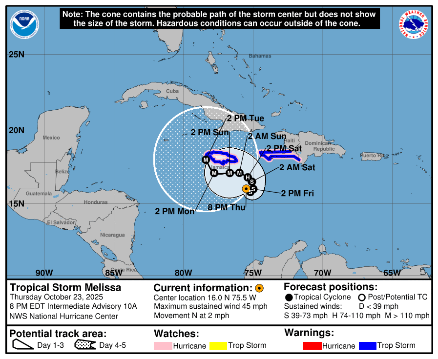
From 11 PM discussion:
The GFS and the HAFS regional hurricane models show
a more initial eastward motion possibly due to center re-formation,
and due to this they forecast a track east of Jamaica, followed by
an eventual northward motion toward eastern Cuba. The ECMWF,
Canadian, UKMET, HFIP Corrected Consensus, and Google DeepMind
forecast a more westerly track that passes south of Jamaica,
followed by a northward turn near or west of the western end of the
island near the end of the forecast period. The HRWF, HMON, and the
other consensus models are in between these and forecast the center
to cross Jamaica. The new forecast continues to follow the more
westerly solution and is little changed from the previous forecast.
4 likes
Visit the Caribbean-Central America Weather Thread where you can find at first post web cams,radars
and observations from Caribbean basin members Click Here
and observations from Caribbean basin members Click Here
-
cheezyWXguy

- Category 5
- Posts: 6180
- Joined: Mon Feb 13, 2006 12:29 am
- Location: Dallas, TX
Re: NATL: MELISSA - Tropical Storm - Discussion
Sooner or later this storm is gonna blow its stack. That is some seriously deep convection blowing up all over it.
4 likes

Re: NATL: MELISSA - Tropical Storm - Discussion
I'm confused. The 11pm EDT advisory says the new forecast track is "little changed from the previous forecast", but it actually seems substantially closer to Jamaica than 5pm?
0 likes

Re: NATL: MELISSA - Tropical Storm - Discussion
-Atlantic 2025 ACE finally just reached 100.
-Though Melissa has yet to produce much ACE (2.2), there’s a whole lot of potential based on the NHC forecast of a combo of very slow movement for many days and reaching cat 4 status in a few days. IF this all materializes, we’d realistically be looking at the possibility of 30+ more ACE though forecasting the ultimate intensity is at a well above average difficulty for this storm. This is still struggling with shear and thus has been holding pretty steady. On the low end, this could never get much above cat 1 and end up with <15 total ACE.
-Of course, Melissa may not be the last storm.
4 likes
Personal Forecast Disclaimer:
The posts in this forum are NOT official forecasts and should not be used as such. They are just the opinion of the poster and may or may not be backed by sound meteorological data. They are NOT endorsed by any professional institution or storm2k.org. For official information, please refer to the NHC and NWS products.
The posts in this forum are NOT official forecasts and should not be used as such. They are just the opinion of the poster and may or may not be backed by sound meteorological data. They are NOT endorsed by any professional institution or storm2k.org. For official information, please refer to the NHC and NWS products.


-
WaveBreaking

- Category 2

- Posts: 644
- Joined: Sun Jun 30, 2024 11:33 am
- Location: US
Re: NATL: MELISSA - Tropical Storm - Discussion
Sunset a couple hours ago (another one of my "homemade" GeoColor images using the Red, Blue, and Veggie bands)

1 likes
I am NOT a professional meteorologist, so take all of my posts with a grain of salt. My opinions are mine and mine alone.
Return to “Active Storms/Invests - Atlantic/EastPAC/CentralPAC/MED”
Who is online
Users browsing this forum: No registered users and 82 guests