NATL: MELISSA - Tropical Storm - Discussion

Current storms and invests:

Moderators: hurricanetrack, S2k Moderators


The posts in this forum are NOT official forecasts and should not be used as such. They are just the opinion of the poster and may or may not be backed by sound meteorological data. They are NOT endorsed by any professional institution or STORM2K. For official information, please refer to products from the National Hurricane Center and National Weather Service.

Help Support Storm2K
Message
Author
User avatar
Buck
S2K Supporter
S2K Supporter
Posts: 1196
Joined: Fri Sep 10, 2004 12:04 pm
Location: Atlanta, GA

Re: NATL: MELISSA - Tropical Storm - Discussion

#441 Postby Buck » Fri Oct 24, 2025 11:49 am

sasha_B wrote:Recon is observing 50~60 kt flight-level winds, and Melissa's satellite presentation is still improving. If that trend persists, I think it's quite possible that the NHC will go with 45 kts on the 18z advisory, which would be in line with their forecasts from last night.


Special advisory:

12:30 PM EDT Fri Oct 24
Location: 15.6°N 74.5°W
Moving: ESE at 2 mph
Min pressure: 999 mb
Max sustained: 60 mph
2 likes   

User avatar
GCANE
S2K Supporter
S2K Supporter
Posts: 11859
Joined: Mon Oct 22, 2007 8:03 am

Re: NATL: MELISSA - Tropical Storm - Discussion

#442 Postby GCANE » Fri Oct 24, 2025 11:51 am

2 likes   

User avatar
cheezyWXguy
Category 5
Category 5
Posts: 6188
Joined: Mon Feb 13, 2006 12:29 am
Location: Dallas, TX

Re: NATL: MELISSA - Tropical Storm - Discussion

#443 Postby cheezyWXguy » Fri Oct 24, 2025 11:51 am

Recon suggests we are seeing more of a “meeting in the middle” scenario where the mlc and llc are converging, rather than a scenario where the mlc drills down to the surface and the old llc is discarded. Intensification looks to be occurring faster now.
2 likes   

User avatar
GCANE
S2K Supporter
S2K Supporter
Posts: 11859
Joined: Mon Oct 22, 2007 8:03 am

Re: NATL: MELISSA - Tropical Storm - Discussion

#444 Postby GCANE » Fri Oct 24, 2025 11:53 am

Now 80mm/hr rain rate
A monster in the making

https://www.tropicaltidbits.com/recon/r ... series.png
0 likes   

User avatar
GCANE
S2K Supporter
S2K Supporter
Posts: 11859
Joined: Mon Oct 22, 2007 8:03 am

Re: NATL: MELISSA - Tropical Storm - Discussion

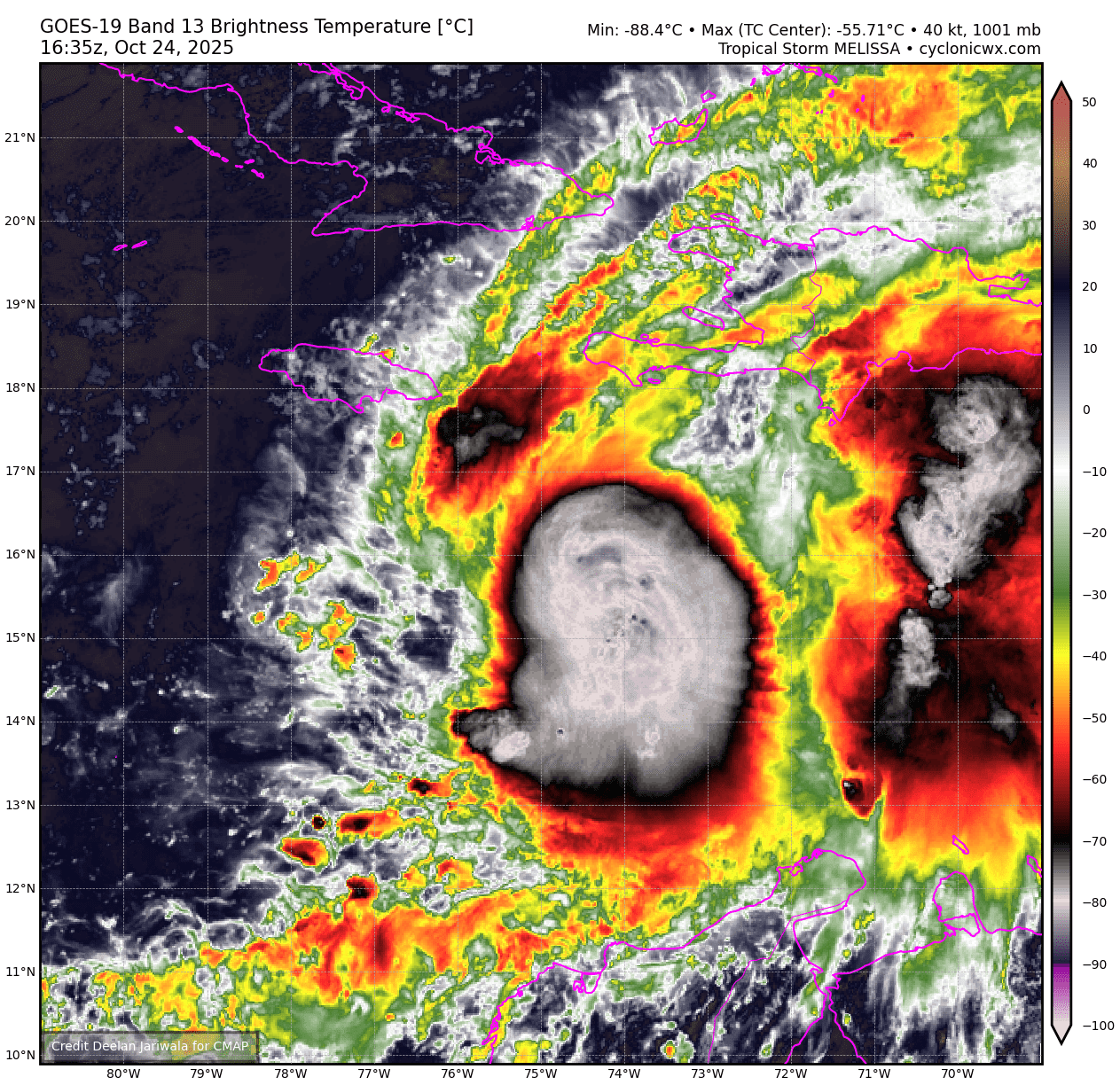
#445 Postby GCANE » Fri Oct 24, 2025 11:56 am

Tropical Storm Melissa Tropical Cyclone Update
NWS National Hurricane Center Miami FL AL132025
1230 PM EDT Fri Oct 24 2025

...AIRCRAFT DATA INDICATES THAT MELISSA IS STRENGTHENING...

Air Force Reserve reconnaissance aircraft data indicates that
Melissa is strengthening, and maximum sustained winds are now
estimated to be 60 mph (95 km/h) with higher gusts. The minimum
pressure from aircraft dropsonde data has dropped to 999 mb
(29.50 inches).

SUMMARY OF 1230 PM EDT...1630 UTC...INFORMATION
---------------------------------------------------
LOCATION...15.6N 74.5W
ABOUT 220 MI...355 KM SE OF KINGSTON JAMAICA
ABOUT 250 MI...405 KM SW OF PORT AU PRINCE HAITI
MAXIMUM SUSTAINED WINDS...60 MPH...95 KM/H
PRESENT MOVEMENT...ESE OR 105 DEGREES AT 2 MPH...4 KM/H
MINIMUM CENTRAL PRESSURE...999 MB...29.50 INCHES

$$
Forecaster Papin
0 likes   

underthwx
Category 5
Category 5
Posts: 2365
Joined: Sat Jul 30, 2011 2:14 pm
Location: Brazoria County Texas

Re: NATL: MELISSA - Tropical Storm - Discussion

#446 Postby underthwx » Fri Oct 24, 2025 11:56 am

Does Melissa have the potential to affect Florida?
0 likes   

zzzh
Category 4
Category 4
Posts: 971
Joined: Thu Sep 02, 2021 1:13 pm

Re: NATL: MELISSA - Tropical Storm - Discussion

#447 Postby zzzh » Fri Oct 24, 2025 11:58 am

Image
0 likes   

User avatar
Iceresistance
Category 5
Category 5
Posts: 9331
Age: 22
Joined: Sat Oct 10, 2020 9:45 am
Location: Tecumseh, OK/Norman, OK

Re: NATL: MELISSA - Tropical Storm - Discussion

#448 Postby Iceresistance » Fri Oct 24, 2025 11:58 am

I do not like the look of Melissa
Image
https://s12.gifyu.com/images/b3dLD.png
3 likes   
Bill 2015 & Beta 2020

Winter 2020-2021 :cold:

All observations are in Tecumseh, OK unless otherwise noted.

Winter posts are focused mainly for Oklahoma & Texas.

Take any of my forecasts with a grain of salt, refer to the NWS, SPC, and NHC for official information

Never say Never with weather! Because ANYTHING is possible!

User avatar
GCANE
S2K Supporter
S2K Supporter
Posts: 11859
Joined: Mon Oct 22, 2007 8:03 am

Re: NATL: MELISSA - Tropical Storm - Discussion

#449 Postby GCANE » Fri Oct 24, 2025 11:59 am

She is pushing out in all quads.
Linking up to the EPAC.
Unlimited hot water.
Likely a major within 24 hours.
Hopefully an EWRC before Jamaica.
Sending prayers.
5 likes   

User avatar
GCANE
S2K Supporter
S2K Supporter
Posts: 11859
Joined: Mon Oct 22, 2007 8:03 am

Re: NATL: MELISSA - Tropical Storm - Discussion

#450 Postby GCANE » Fri Oct 24, 2025 12:06 pm

Recon just measured surface winds at Cat 1
65.4 knots

Wait and see if it verifies.
0 likes   

User avatar
Iceresistance
Category 5
Category 5
Posts: 9331
Age: 22
Joined: Sat Oct 10, 2020 9:45 am
Location: Tecumseh, OK/Norman, OK

Re: NATL: MELISSA - Tropical Storm - Discussion

#451 Postby Iceresistance » Fri Oct 24, 2025 12:08 pm

It's already wrapping upshear. I think the RI phase has begun for Melissa
Image
https://s12.gifyu.com/images/b3dsc.gif
4 likes   
Bill 2015 & Beta 2020

Winter 2020-2021 :cold:

All observations are in Tecumseh, OK unless otherwise noted.

Winter posts are focused mainly for Oklahoma & Texas.

Take any of my forecasts with a grain of salt, refer to the NWS, SPC, and NHC for official information

Never say Never with weather! Because ANYTHING is possible!

User avatar
GCANE
S2K Supporter
S2K Supporter
Posts: 11859
Joined: Mon Oct 22, 2007 8:03 am

Re: NATL: MELISSA - Tropical Storm - Discussion

#452 Postby GCANE » Fri Oct 24, 2025 12:10 pm

GCANE wrote:Recon just measured surface winds at Cat 1
65.4 knots

Wait and see if it verifies.


Looks like 2nd reading was contaminated.
Will likely go around for another pass.
1 likes   

Pelicane
Tropical Storm
Tropical Storm
Posts: 184
Joined: Tue Sep 13, 2022 1:52 pm
Location: Lafayette, Louisiana

Re: NATL: MELISSA - Tropical Storm - Discussion

#453 Postby Pelicane » Fri Oct 24, 2025 12:10 pm

Image

Shear's clearly letting up now. Look at how the outflow is literally shooting out of the core.
4 likes   

User avatar
GCANE
S2K Supporter
S2K Supporter
Posts: 11859
Joined: Mon Oct 22, 2007 8:03 am

Re: NATL: MELISSA - Tropical Storm - Discussion

#454 Postby GCANE » Fri Oct 24, 2025 12:11 pm

GCANE wrote:
GCANE wrote:Recon just measured surface winds at Cat 1
65.4 knots

Wait and see if it verifies.


Looks like 2nd reading was contaminated.
Will likely go around for another pass.


73mm/hr rain rate
0 likes   

User avatar
aspen
Category 5
Category 5
Posts: 8957
Joined: Sat Oct 12, 2019 7:10 pm
Location: Connecticut, USA

Re: NATL: MELISSA - Tropical Storm - Discussion

#455 Postby aspen » Fri Oct 24, 2025 12:18 pm

Iceresistance wrote:It's already wrapping upshear. I think the RI phase has begun for Melissa
https://s12.gifyu.com/images/b3dsc.gif

Doubt it’s the start of RI yet because there’s still not much of an inner core to speak of. But it’s still significant improvement, and likely setting up a stage of RI starting tomorrow or Sunday.
1 likes   
Irene '11 Sandy '12 Hermine '16 5/15/2018 Derecho Fay '20 Isaias '20 Elsa '21 Henri '21 Ida '21

I am only a meteorology enthusiast who knows a decent amount about tropical cyclones. Look to the professional mets, the NHC, or your local weather office for the best information.

MEANINGLESS_NUMBERS
Category 1
Category 1
Posts: 450
Joined: Mon Nov 02, 2020 1:43 pm

Re: NATL: MELISSA - Tropical Storm - Discussion

#456 Postby MEANINGLESS_NUMBERS » Fri Oct 24, 2025 12:21 pm

underthwx wrote:Does Melissa have the potential to affect Florida?


No
2 likes   
Emily '87, Felix '95, Gert '99, Fabian '03, Humberto '19, Paulette '20, Teddy '20, Fiona '22, Lee '23, Ernesto '24, Humberto/Imelda '25

BobHarlem
Category 5
Category 5
Posts: 2527
Joined: Thu Oct 20, 2005 6:11 pm

Re: NATL: MELISSA - Tropical Storm - Discussion

#457 Postby BobHarlem » Fri Oct 24, 2025 12:24 pm

Jamaica radar doesn't show too much yet, although some of the rain bands are starting to get over the island.

Image
1 likes   

hipshot
Category 2
Category 2
Posts: 607
Joined: Tue Jul 06, 2010 9:18 pm
Location: Dallas, Texas

Re: NATL: MELISSA - Tropical Storm - Discussion

#458 Postby hipshot » Fri Oct 24, 2025 12:27 pm


I wonder how long it will be until that convection on the east side of the center merges with the center. When and if it does, this is
going to be a massive hurricane.
1 likes   

psyclone
S2K Supporter
S2K Supporter
Posts: 4795
Joined: Wed Aug 24, 2005 9:04 pm
Location: palm harbor fl

Re: NATL: MELISSA - Tropical Storm - Discussion

#459 Postby psyclone » Fri Oct 24, 2025 12:33 pm

This looks like classic TC liftoff where we undergo a steady strengthening and organization phase for 12-24 hours or perhaps a bit more and then a period of rapid intensification follows and another day later you're on the precipice of a cat 5.
1 likes   

User avatar
GCANE
S2K Supporter
S2K Supporter
Posts: 11859
Joined: Mon Oct 22, 2007 8:03 am

Re: NATL: MELISSA - Tropical Storm - Discussion

#460 Postby GCANE » Fri Oct 24, 2025 12:35 pm

GCANE wrote:
GCANE wrote:
GCANE wrote:Recon just measured surface winds at Cat 1
65.4 knots

Wait and see if it verifies.


Looks like 2nd reading was contaminated.
Will likely go around for another pass.


73mm/hr rain rate


Looks like heading back to the barn
0 likes   


Return to “Active Storms/Invests - Atlantic/EastPAC/CentralPAC/MED”

Who is online

Users browsing this forum: No registered users and 141 guests