ATL: ERIN - Hurricane - Discussion

Current storms and invests:

Moderators: hurricanetrack, S2k Moderators


The posts in this forum are NOT official forecasts and should not be used as such. They are just the opinion of the poster and may or may not be backed by sound meteorological data. They are NOT endorsed by any professional institution or STORM2K. For official information, please refer to products from the National Hurricane Center and National Weather Service.

Help Support Storm2K
Message
Author
User avatar
Teban54
Category 5
Category 5
Posts: 3241
Joined: Sat May 19, 2018 1:19 pm

Re: ATL: ERIN - Hurricane - Discussion

#501 Postby Teban54 » Sat Aug 16, 2025 5:49 am

kevin wrote:In the last 12 hours Erin has intensified from 70 kt to 115 kt and a 45 mb pressure drop. As far as I know this is pretty much unprecedented in the open MDR. Most ERIs take place in the WCar or Gulf (Wilma, Milton). Even Beryl only has a 30kt wind increase in 12 hours, while Erin has intensified by 45 kt in the same time period. She's gonna be one for the history books. Let's all hope that the models are right and this avoids all land.

Edit: the only hurricane I can think of that has exceeded Erin in terms of ERI in the open MDR is Lee which had a 50 kt increase in 12 hours. Even though that might also be beaten if Erin keeps going like this.

And to think that this happened in a year that had the reputation of a "cool" MDR... Or at least nowhere near as warm as what Lee had to work with.
0 likes   

User avatar
GCANE
S2K Supporter
S2K Supporter
Posts: 11599
Joined: Mon Oct 22, 2007 8:03 am

Re: ATL: ERIN - Hurricane - Discussion

#502 Postby GCANE » Sat Aug 16, 2025 5:53 am

Probability for a Cat5 is now at 60%.
With this RI, I think we get an EWRC before that.

Image
3 likes   

User avatar
Hypercane_Kyle
Category 5
Category 5
Posts: 3376
Joined: Sat Mar 07, 2015 7:58 pm
Location: Cape Canaveral, FL

Re: ATL: ERIN - Hurricane - Discussion

#503 Postby Hypercane_Kyle » Sat Aug 16, 2025 5:59 am

MSLP down to 942mb. Rapid intensification is continuing.
1 likes   
My posts are my own personal opinion, defer to the National Hurricane Center (NHC) and other NOAA products for decision making during hurricane season.

User avatar
kevin
Category 5
Category 5
Posts: 2631
Age: 26
Joined: Wed Aug 28, 2019 4:35 am

Re: ATL: ERIN - Hurricane - Discussion

#504 Postby kevin » Sat Aug 16, 2025 5:59 am

Another pass by NOAA2.

Minimum extrapolated pressure = 942.6 mb with 19 kt wind nearby -> 941 mb
Peak FL wind = 137 kt -> 123 kt estimate at the surface

Based on this I'd put Erin's current intensity at 941mb/125kt.
Last edited by kevin on Sat Aug 16, 2025 6:01 am, edited 1 time in total.
1 likes   

User avatar
TheDreamTraveler
Category 2
Category 2
Posts: 642
Joined: Sun Aug 22, 2010 3:10 am
Location: PA

Re: ATL: ERIN - Hurricane - Discussion

#505 Postby TheDreamTraveler » Sat Aug 16, 2025 6:00 am

cycloneye wrote:A very noticable jog to the west.

https://i.imgur.com/rDVIoNA.gif


I thought she was moving WNW. That looks like a steady due West movement. Not even wobbling or stair stepping. I'm assuming the WNW movement should resume but that's a bit concerning the farther west and south this stays the more likely there may be slight impacts from the outside edges of Erin in the Outer Banks
0 likes   

User avatar
kevin
Category 5
Category 5
Posts: 2631
Age: 26
Joined: Wed Aug 28, 2019 4:35 am

Re: ATL: ERIN - Hurricane - Discussion

#506 Postby kevin » Sat Aug 16, 2025 6:06 am

Ignore the archer positioning, but this ADT estimate image shows the current location of Erin compared to the forecast location (blue square). Clearly going SW of the forecast the last few hours, but still too soon to say whether it's just a wobble or more than that.

Image
1 likes   

User avatar
Hypercane_Kyle
Category 5
Category 5
Posts: 3376
Joined: Sat Mar 07, 2015 7:58 pm
Location: Cape Canaveral, FL

Re: ATL: ERIN - Hurricane - Discussion

#507 Postby Hypercane_Kyle » Sat Aug 16, 2025 6:13 am

TheDreamTraveler wrote:
cycloneye wrote:A very noticable jog to the west.

https://i.imgur.com/rDVIoNA.gif


I thought she was moving WNW. That looks like a steady due West movement. Not even wobbling or stair stepping. I'm assuming the WNW movement should resume but that's a bit concerning the farther west and south this stays the more likely there may be slight impacts from the outside edges of Erin in the Outer Banks


There's actually a bit of a southerly component to its movement. I doubt it changes the long-term synopsis very much, although could get closer to the Bahamas.
0 likes   
My posts are my own personal opinion, defer to the National Hurricane Center (NHC) and other NOAA products for decision making during hurricane season.

HurricaneIrma
Tropical Low
Tropical Low
Posts: 41
Age: 44
Joined: Mon Sep 03, 2018 9:37 am
Location: Wilmington NC

Re: ATL: ERIN - Hurricane - Discussion

#508 Postby HurricaneIrma » Sat Aug 16, 2025 6:16 am

You updated advisory at 5:50 this morning located in at 19.7 as a 5:00 a.m. this morning it was located in 19.8 but as of 2:00 a.m. this morning it was back to 19.7 so with that said is it potentially wobbling or drifting slightly Southward of Due West?
0 likes   

User avatar
GCANE
S2K Supporter
S2K Supporter
Posts: 11599
Joined: Mon Oct 22, 2007 8:03 am

Re: ATL: ERIN - Hurricane - Discussion

#509 Postby GCANE » Sat Aug 16, 2025 6:18 am

Last down-looking radar estimate at 10:23Z also showing south of forecast track.
Should get an eye drop from Kermit very soon.
Last drop showed a small inversion at 870mb.
Watching if this develops more on the current drop which would indicate an EWRC may be developing.
0 likes   

User avatar
GCANE
S2K Supporter
S2K Supporter
Posts: 11599
Joined: Mon Oct 22, 2007 8:03 am

Re: ATL: ERIN - Hurricane - Discussion

#510 Postby GCANE » Sat Aug 16, 2025 6:22 am

Going to be about 19.55N 61.83W
Even farther south of forecast track.
I would say not a wobble.
0 likes   

User avatar
kevin
Category 5
Category 5
Posts: 2631
Age: 26
Joined: Wed Aug 28, 2019 4:35 am

Re: ATL: ERIN - Hurricane - Discussion

#511 Postby kevin » Sat Aug 16, 2025 6:25 am

GCANE wrote:Going to be about 19.55N 61.83W
Even farther south of forecast track.
I would say not a wobble.


Agreed that the deviation is starting to become significant, the coordinates you mention indicate WSW for the last 3 hours. While steering currents will still largely be the same, the enormous discrepancy between Erin's true intensity and the modelled intensity initialization in the 06z runs also makes it difficult to trust that model cycle. The coming hours and the subsequent 12z cycle will hopefully give greater confidence in Erin's forecast track.
Last edited by kevin on Sat Aug 16, 2025 6:26 am, edited 1 time in total.
2 likes   

User avatar
Nimbus
Category 5
Category 5
Posts: 5341
Joined: Mon Jul 19, 2004 10:54 am

Re: ATL: ERIN - Hurricane - Discussion

#512 Postby Nimbus » Sat Aug 16, 2025 6:26 am

kevin wrote:Ignore the archer positioning, but this ADT estimate image shows the current location of Erin compared to the forecast location (blue square). Clearly going SW of the forecast the last few hours, but still too soon to say whether it's just a wobble or more than that.

https://i.imgur.com/zV6OU4s.gif


The RI Erin did overnight blew a lot of outflow into the ridge to her north a little earlier than forecast.
ICON model had the strongest system with enough ridge that tracked dangerously close to the Carolinas.
Common feedback issue that can change the track of major hurricanes, so we need to watch the model runs.
3 likes   

User avatar
REDHurricane
Category 1
Category 1
Posts: 406
Age: 28
Joined: Sun Jul 03, 2022 2:36 pm
Location: Northeast Pacific Ocean

Re: ATL: ERIN - Hurricane - Discussion

#513 Postby REDHurricane » Sat Aug 16, 2025 6:29 am

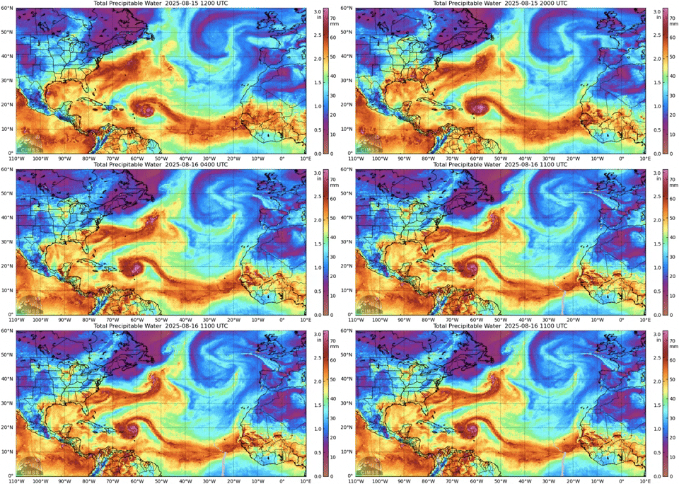
Pretty cool to see Erin still sucking in that ITCZ moisture through a straw that's hundreds of miles long:

Image
3 likes   

User avatar
weeniepatrol
Category 5
Category 5
Posts: 1295
Joined: Sat Aug 22, 2020 5:30 pm
Location: WA State

Re: ATL: ERIN - Hurricane - Discussion

#514 Postby weeniepatrol » Sat Aug 16, 2025 6:30 am

Very normal August 16th MDR activity here yes

4 likes   

User avatar
GCANE
S2K Supporter
S2K Supporter
Posts: 11599
Joined: Mon Oct 22, 2007 8:03 am

Re: ATL: ERIN - Hurricane - Discussion

#515 Postby GCANE » Sat Aug 16, 2025 6:30 am

Kermit VDM tags it at 19.54N 61.84W
0 likes   

User avatar
kevin
Category 5
Category 5
Posts: 2631
Age: 26
Joined: Wed Aug 28, 2019 4:35 am

Re: ATL: ERIN - Hurricane - Discussion

#516 Postby kevin » Sat Aug 16, 2025 6:30 am

Look how close the AF308 plane is to the eye and the pressure is still only ~1000mb with 44 kt FL winds. The pressure gradient near the eye must be incredible.

Image
2 likes   

HurricaneIrma
Tropical Low
Tropical Low
Posts: 41
Age: 44
Joined: Mon Sep 03, 2018 9:37 am
Location: Wilmington NC

Re: ATL: ERIN - Hurricane - Discussion

#517 Postby HurricaneIrma » Sat Aug 16, 2025 6:31 am

SUMMARY OF 200 AM AST...0600 UTC...INFORMATION
----------------------------------------------
LOCATION...19.7N 60.6W

SUMMARY OF 500 AM AST...0900 UTC...INFORMATION
----------------------------------------------
LOCATION...19.8N 61.1W

5:50am update. LOCATION...19.6N 61.5W
1 likes   

User avatar
REDHurricane
Category 1
Category 1
Posts: 406
Age: 28
Joined: Sun Jul 03, 2022 2:36 pm
Location: Northeast Pacific Ocean

Re: ATL: ERIN - Hurricane - Discussion

#518 Postby REDHurricane » Sat Aug 16, 2025 6:33 am

518 posts currently in this thread... I bet that'll be doubled by the end of today lol
3 likes   

User avatar
GCANE
S2K Supporter
S2K Supporter
Posts: 11599
Joined: Mon Oct 22, 2007 8:03 am

Re: ATL: ERIN - Hurricane - Discussion

#519 Postby GCANE » Sat Aug 16, 2025 6:38 am

One notable thing that the models haven't picked up on is the ULL at 28N 41W.
This is a big factor in the deviation of strengthening and may play into the deviation of track forecast.

Image
0 likes   

User avatar
Woofde
Category 1
Category 1
Posts: 493
Joined: Tue Jul 06, 2021 11:33 am

Re: RE: Re: ATL: ERIN - Hurricane - Discussion

#520 Postby Woofde » Sat Aug 16, 2025 6:38 am

REDHurricane wrote:518 posts currently in this thread... I bet that'll be doubled by the end of today lol
She's going to be putting on quite the show the next few days. Just wait till she hits ~27N, there's an SST hotpot there, Cat 5 very possible.Image
0 likes   


Return to “Active Storms/Invests - Atlantic/EastPAC/CentralPAC/MED”

Who is online

Users browsing this forum: Google Adsense [Bot] and 150 guests