
https://x.com/Mike__Gagliardi/status/1981858838337949838
NATL: MELISSA - Hurricane - Discussion
Moderators: hurricanetrack, S2k Moderators

The posts in this forum are NOT official forecasts and should not be used as such. They are just the opinion of the poster and may or may not be backed by sound meteorological data. They are NOT endorsed by any professional institution or STORM2K. For official information, please refer to products from the National Hurricane Center and National Weather Service.

Re: NATL: MELISSA - Tropical Storm - Discussion
Dry air from the bottom of the trof is quickly being filled in with moist air.
https://www.tropicaltidbits.com/sat/sat ... uct=wv_mid
https://www.tropicaltidbits.com/sat/sat ... uct=wv_mid
0 likes
-
jlauderdal
- S2K Supporter

- Posts: 7235
- Joined: Wed May 19, 2004 5:46 am
- Location: NE Fort Lauderdale
- Contact:
Re: NATL: MELISSA - Tropical Storm - Discussion
GCANE wrote:Dry air from the bottom of the trof is quickly being filled in with moist air.
https://www.tropicaltidbits.com/sat/sat ... uct=wv_mid
Classic Fall setup, look at the flow working on the system keeping it pinned. This was a blockbuster Gulf system two weeks late.
1 likes

Re: NATL: MELISSA - Tropical Storm - Discussion
Definitely moving west now. Incredibly cold cloud tops in CDO. She should RI today.
0 likes
-
cycloneye

- Admin

- Posts: 148055
- Age: 69
- Joined: Thu Oct 10, 2002 10:54 am
- Location: San Juan, Puerto Rico
Re: NATL: MELISSA - Tropical Storm - Discussion
Peak Flight-Level Winds: 68kt at 10:47z
Minimum Extrap. Pressure: 985.3mb at 10:50z
Minimum Extrap. Pressure: 985.3mb at 10:50z
2 likes
Visit the Caribbean-Central America Weather Thread where you can find at first post web cams,radars
and observations from Caribbean basin members Click Here
and observations from Caribbean basin members Click Here

Re: NATL: MELISSA - Tropical Storm - Discussion
ronjon wrote:Definitely moving west now. Incredibly cold cloud tops in CDO. She should RI today.
Recon mission is checking this morning, flying west near 16.18N
Both 00z GFS and ECM have her gaining a little more latitude before a WSW slide into the blue mountains.
Only the UKMET is still showing a hook NE over western Jamaica and that is as the weak storm outlier.
100 year flood map could help officials with evacuation but Jamaican politics being what they are.
0 likes
Re: NATL: MELISSA - Tropical Storm - Discussion
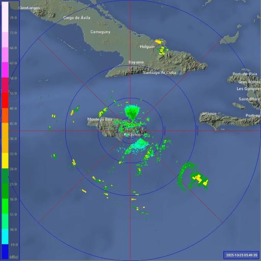
A bit easier to see on radar this morning. (note the mountains cut off angles of the radar there)
3 likes
-
Deshaunrob17
- Tropical Storm

- Posts: 211
- Joined: Tue Aug 18, 2020 7:49 am
Re: NATL: MELISSA - Tropical Storm - Discussion
This is going to be just an easy heavy system ( assuming due to westerly shear) that the hurricane could make landfall in east/ central Jamaica and barely impacts west Jamaica. Meanwhile in these scenarios even Haiti gets hammered with rain bands
0 likes

Re: NATL: MELISSA - Tropical Storm - Discussion
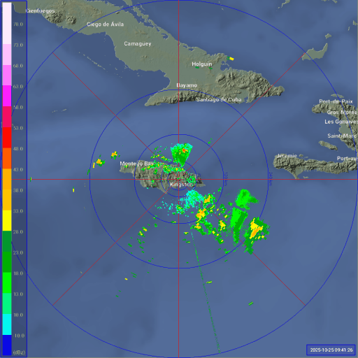
Significant improvement over the time of this loop. Assuming no more hiccups, a hurricane at the 11am EDT advisory seems like a given.

2 likes
-
Hypercane_Kyle

- Category 5

- Posts: 3420
- Joined: Sat Mar 07, 2015 7:58 pm
- Location: Cape Canaveral, FL
Re: NATL: MELISSA - Tropical Storm - Discussion
Should be a hurricane later this morning.

3 likes
My posts are my own personal opinion, defer to the National Hurricane Center (NHC) and other NOAA products for decision making during hurricane season.
-
cycloneye
- Admin
- Posts: 148055
- Age: 69
- Joined: Thu Oct 10, 2002 10:54 am
- Location: San Juan, Puerto Rico
Re: NATL: MELISSA - Tropical Storm - Discussion
Big improvement this morning at TDR from last nights mission.

6 likes
Visit the Caribbean-Central America Weather Thread where you can find at first post web cams,radars
and observations from Caribbean basin members Click Here
and observations from Caribbean basin members Click Here
-
eastcoastFL

- Category 5
- Posts: 3950
- Age: 43
- Joined: Thu Apr 12, 2007 12:29 pm
- Location: Palm City, FL
Re: NATL: MELISSA - Tropical Storm - Discussion
A very rough couple of days and weeks ahead for our friends in the Caribbean. There haven't been any major track changes so it appears the CONUS will be spared.
4 likes
Personal Forecast Disclaimer:
The posts in this forum are NOT official forecast and should not be used as such. They are just the opinion of the poster and may or may not be backed by sound meteorological data. They are NOT endorsed by any professional institution or storm2k.org. For official information, please refer to the NHC and NWS products.
The posts in this forum are NOT official forecast and should not be used as such. They are just the opinion of the poster and may or may not be backed by sound meteorological data. They are NOT endorsed by any professional institution or storm2k.org. For official information, please refer to the NHC and NWS products.
-
cycloneye
- Admin
- Posts: 148055
- Age: 69
- Joined: Thu Oct 10, 2002 10:54 am
- Location: San Juan, Puerto Rico
Re: NATL: MELISSA - Tropical Storm - Discussion
The meso floater.

5 likes
Visit the Caribbean-Central America Weather Thread where you can find at first post web cams,radars
and observations from Caribbean basin members Click Here
and observations from Caribbean basin members Click Here

Re: NATL: MELISSA - Tropical Storm - Discussion
12z Best Track:
AL, 13, 2025102512, , BEST, 0, 163N, 750W, 60, 982, TS...
2 likes

Re: NATL: MELISSA - Tropical Storm - Discussion
abajan wrote:12z Best Track:AL, 13, 2025102512, , BEST, 0, 163N, 750W, 60, 982, TS...
Isn't that a more westerly track?
0 likes
Re: NATL: MELISSA - Tropical Storm - Discussion
hipshot wrote:abajan wrote:12z Best Track:AL, 13, 2025102512, , BEST, 0, 163N, 750W, 60, 982, TS...
Isn't that a more westerly track?
She’s hardly been moving as she was at 16.3N, 75.0W at 5AM EDT.
0 likes
Personal Forecast Disclaimer:
The posts in this forum are NOT official forecasts and should not be used as such. They are just the opinion of the poster and may or may not be backed by sound meteorological data. They are NOT endorsed by any professional institution or storm2k.org. For official information, please refer to the NHC and NWS products.
The posts in this forum are NOT official forecasts and should not be used as such. They are just the opinion of the poster and may or may not be backed by sound meteorological data. They are NOT endorsed by any professional institution or storm2k.org. For official information, please refer to the NHC and NWS products.
Re: NATL: MELISSA - Tropical Storm - Discussion
Looks to me like dual hot towers are now firing around 16.5N 75.0W, roughly where the center is.

0 likes
-
Hurricane2022

- Category 5
- Posts: 1772
- Joined: Tue Aug 23, 2022 11:38 pm
- Location: Araçatuba, Brazil
Re: NATL: MELISSA - Tropical Storm - Discussion
Of course Melissa stopped from intensifying just when recon gets there
https://x.com/MikeAdcockWx/status/1982077885809914227
https://x.com/MikeAdcockWx/status/1982077885809914227
0 likes
Sorry for the bad English sometimes...!
For reliable and detailed information for any meteorological phenomenon, please consult the National Hurricane Center, Joint Typhoon Warning Center , or your local Meteo Center.
--------
ECCE OMNIA NOVA FACIAM (Ap 21,5).
For reliable and detailed information for any meteorological phenomenon, please consult the National Hurricane Center, Joint Typhoon Warning Center , or your local Meteo Center.
--------
ECCE OMNIA NOVA FACIAM (Ap 21,5).
-
cheezyWXguy

- Category 5
- Posts: 6195
- Joined: Mon Feb 13, 2006 12:29 am
- Location: Dallas, TX
Re: NATL: MELISSA - Tropical Storm - Discussion
The pressure gradient looks a lot tighter on the recon data this morning. Windfield still a little loose but much closer to being axisymmetric. Seems like a good bet that faster intensification will begin in the next few hours.
1 likes
Return to “Active Storms/Invests - Atlantic/EastPAC/CentralPAC/MED”
Who is online
Users browsing this forum: No registered users and 105 guests