
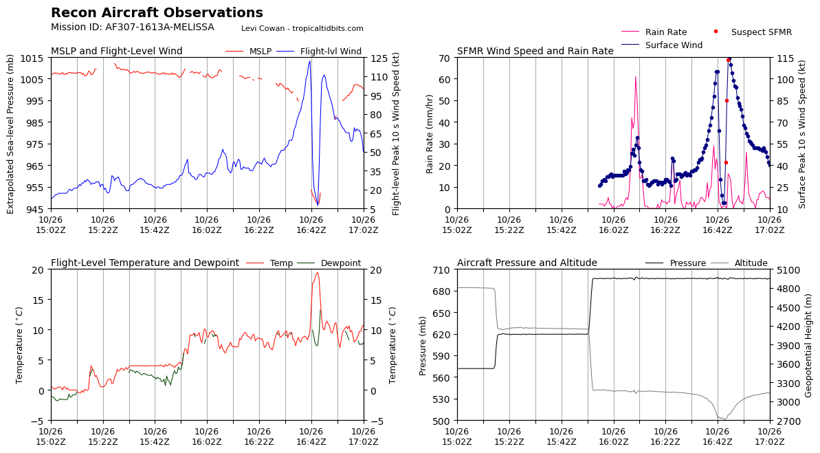
If the AF plane's pressure extrap is accurate (medium if) Melissa might have deepened a bit since NOAA left, the last HDOB line reported 953.6mb still with 97kts FL wind and 105kt SFMR. Wait for the dropsonde to be sure. This was also in the weaker SE quad so winds might be up a bit.
Edit: 946.9mb in the eye, so maybe a few mb depending on how the extrap is calibrated relative to NOAA. There was a 114kt SFMR reading heading out of the eye, but only 111kt flight level winds. That's certainly not going to justify anything over 110kts.
NATL: MELISSA - Hurricane - Discussion
Moderators: hurricanetrack, S2k Moderators

The posts in this forum are NOT official forecasts and should not be used as such. They are just the opinion of the poster and may or may not be backed by sound meteorological data. They are NOT endorsed by any professional institution or STORM2K. For official information, please refer to products from the National Hurricane Center and National Weather Service.

Re: NATL: MELISSA - Hurricane - Discussion
Last edited by Travorum on Sun Oct 26, 2025 11:57 am, edited 2 times in total.
1 likes
-
WaveBreaking

- Category 2

- Posts: 666
- Joined: Sun Jun 30, 2024 11:33 am
- Location: US
Re: NATL: MELISSA - Hurricane - Discussion
Recon found 122 kt FL winds in the SE eyewall.

0 likes
I am NOT a professional meteorologist, so take all of my posts with a grain of salt. My opinions are mine and mine alone.
-
cycloneye

- Admin

- Posts: 148108
- Age: 69
- Joined: Thu Oct 10, 2002 10:54 am
- Location: San Juan, Puerto Rico
Re: NATL: MELISSA - Hurricane - Discussion
Minimum Extrap. Pressure: 946.9mb at 16:45z
3 likes
Visit the Caribbean-Central America Weather Thread where you can find at first post web cams,radars
and observations from Caribbean basin members Click Here
and observations from Caribbean basin members Click Here
-
cycloneye
- Admin
- Posts: 148108
- Age: 69
- Joined: Thu Oct 10, 2002 10:54 am
- Location: San Juan, Puerto Rico
Re: NATL: MELISSA - Hurricane - Discussion
Dropsonde is at 949 mbs.

2 likes
Visit the Caribbean-Central America Weather Thread where you can find at first post web cams,radars
and observations from Caribbean basin members Click Here
and observations from Caribbean basin members Click Here

Re: NATL: MELISSA - Hurricane - Discussion
Note that there's no double wind maxima on this eye pass, even though it doesn't strictly preclude the onset of an EWRC.
Edit: I may have spoken too soon, as the next set of data showed a small wind maximum albeit far removed from the eyewall.
Edit: I may have spoken too soon, as the next set of data showed a small wind maximum albeit far removed from the eyewall.
2 likes


Re: NATL: MELISSA - Hurricane - Discussion
Much like Rafael last year, if it weren't for recon observations, this could be treated as a much stronger storm. Subjective and objective satellite estimates (final T-numbers, not instantaneous!) have reached 7.0, and raw numbers have for the most part been hovering between 7.1 and 7.5 for upwards of 12 hours. Probably a number of factors inducing this upward bias in Dvorak intensity estimates.
3 likes
-
cycloneye
- Admin
- Posts: 148108
- Age: 69
- Joined: Thu Oct 10, 2002 10:54 am
- Location: San Juan, Puerto Rico
Re: NATL: MELISSA - Hurricane - Discussion
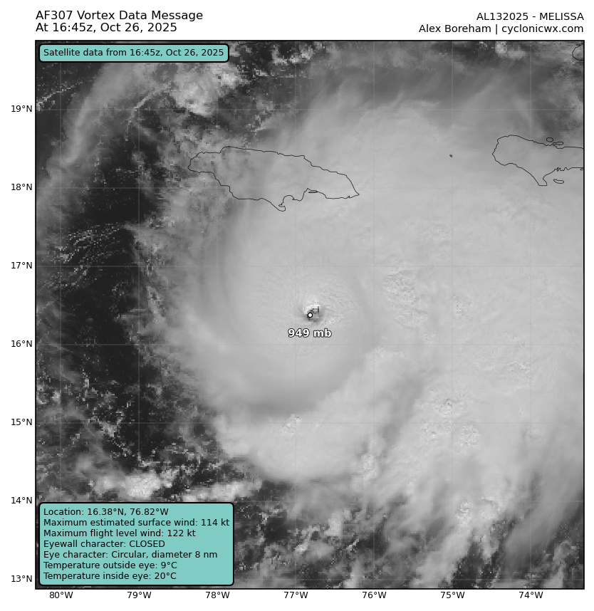
Eye is closed and is smaller.
VORTEX DATA MESSAGE AL132025
A. 26/16:45:00Z
B. 16.38 deg N 076.82 deg W
C. 700 mb 2680 m
D. 949 mb
E. 360 deg 26 kt
F. CLOSED
G. C8
H. 105 kt
I. 107 deg 8 nm 16:42:30Z
J. 211 deg 122 kt
K. 110 deg 9 nm 16:42:00Z
L. 114 kt
M. 276 deg 5 nm 16:47:00Z
N. 005 deg 111 kt
O. 282 deg 6 nm 16:47:30Z
P. 9 C / 3063 m
Q. 20 C / 3044 m
R. 7 C / NA
S. 12345 / 7
T. 0.02 / 3 nm
U. AF307 1613A MELISSA OB 05
MAX FL WIND 122 KT 110 / 9 NM 16:42:00Z
;
3 likes
Visit the Caribbean-Central America Weather Thread where you can find at first post web cams,radars
and observations from Caribbean basin members Click Here
and observations from Caribbean basin members Click Here
-
Iceresistance

- Category 5

- Posts: 9354
- Age: 22
- Joined: Sat Oct 10, 2020 9:45 am
- Location: Tecumseh, OK/Norman, OK
Re: NATL: MELISSA - Hurricane - Discussion
Melissa's eye is now a pinhole type at 8 Nautical Miles, uh oh
https://s12.gifyu.com/images/b3ujb.png
https://s12.gifyu.com/images/b3ujb.png
4 likes
Bill 2015 & Beta 2020
Winter 2020-2021
All observations are in Tecumseh, OK unless otherwise noted.
Winter posts are focused mainly for Oklahoma & Texas.
Take any of my forecasts with a grain of salt, refer to the NWS, SPC, and NHC for official information
Never say Never with weather! Because ANYTHING is possible!
Winter 2020-2021
All observations are in Tecumseh, OK unless otherwise noted.
Winter posts are focused mainly for Oklahoma & Texas.
Take any of my forecasts with a grain of salt, refer to the NWS, SPC, and NHC for official information
Never say Never with weather! Because ANYTHING is possible!

Re: NATL: MELISSA - Hurricane - Discussion
Eye contraction can also happen prior to an EWRC. The next pass should provide clarification. If the pressure has dropped significantly then it's most likely a stable pinhole, otherwise it could instead be eye size contractions as a precursor to an EWRC.
8 likes
-
cheezyWXguy

- Category 5
- Posts: 6203
- Joined: Mon Feb 13, 2006 12:29 am
- Location: Dallas, TX
Re: NATL: MELISSA - Hurricane - Discussion Update= Latest VDM has eye much smaller, 8 miles
Eye dropsonde had 949mb with 26kt. Good for 947mb.
2 likes
-
CrazyC83
- Professional-Met

- Posts: 34169
- Joined: Tue Mar 07, 2006 11:57 pm
- Location: Deep South, for the first time!
Re: NATL: MELISSA - Hurricane - Discussion Update= Latest VDM has eye much smaller, 8 miles
Without Recon, this would probably be analyzed at 130-135 kt right now. The best guess on that data is 115 kt for the actual intensity.
It's almost an inverse of Delta 2020, which in the Caribbean never went above T5.0 but aircraft supported 120 kt.
It's almost an inverse of Delta 2020, which in the Caribbean never went above T5.0 but aircraft supported 120 kt.
8 likes
Re: NATL: MELISSA - Hurricane - Discussion Update= Latest VDM has eye much smaller, 8 miles
CrazyC83 wrote:Without Recon, this would probably be analyzed at 130-135 kt right now. The best guess on that data is 115 kt for the actual intensity.
It's almost an inverse of Delta 2020, which in the Caribbean never went above T5.0 but aircraft supported 120 kt.
It's also a miniature and less extreme version of Eta, with raw T8.0+ when recon measured 130 kt in reality.
2 likes
-
storm_in_a_teacup

- Category 1

- Posts: 476
- Age: 33
- Joined: Wed Aug 16, 2017 5:01 pm
- Location: Huntsville, Alabama (originally from Houston)
- Contact:
Re: NATL: MELISSA - Hurricane - Discussion
chaser1 wrote:Just want to shout out a quick "THANKS" to fellow members for imparting some really insightful details and analysis regarding a few micro characteristics at hand that play into a major hurricane's subtle fluctuations, RI, and the often occuring "secondary" or appendage blob affect that seems to occur in an number of Atlantic basin storms. The combination of a great satellite and radar presentation along with well explained & concise explanation makes for a great sit-back with popcorn visual learning event

I just wish I wasn’t super tired then I could actually figure out what my questions about the explanations are
1 likes
I know I can't straddle the atmosphere...just a tiny storm in your teacup, girl.
Re: NATL: MELISSA - Hurricane - Discussion Update= Latest VDM has eye much smaller, 8 miles
CrazyC83 wrote:Without Recon, this would probably be analyzed at 130-135 kt right now. The best guess on that data is 115 kt for the actual intensity.
It's almost an inverse of Delta 2020, which in the Caribbean never went above T5.0 but aircraft supported 120 kt.
Given the fact that deepening seems to have resumed, albeit at a slower pace, and there's been no appreciable reduction in satellite estimates, it's possible that they maintain intensity at 18z for continuity's sake until there's clearer evidence that an EWRC is in progress.
1 likes
-
USTropics
- Professional-Met
- Posts: 2712
- Joined: Sun Aug 12, 2007 3:45 am
- Location: Florida State University
Re: NATL: MELISSA - Hurricane - Discussion Update= Latest VDM has eye much smaller, 8 miles
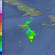
It's difficult to ascertain exactly what is going on without some tail doppler radar. While fully closed, the western side of the eyewall hasn't exhibited the same level of depth as the eastern eyewall for much of past 6 hours (with even brief periods of being open). Here is the latest radar image:

TROPICS-5 pass from about 2 hours ago:


TROPICS-5 pass from about 2 hours ago:
2 likes

Re: NATL: MELISSA - Hurricane - Discussion Update= Latest VDM has eye much smaller, 8 miles
USTropics wrote:It's difficult to ascertain exactly what is going on without some tail doppler radar. While fully closed, the western side of the eyewall hasn't exhibited the same level of depth as the eastern eyewall for much of past 6 hours (with even brief periods of being open). Here is the latest radar image:
https://i.imgur.com/PmrlUJW.png
TROPICS-5 pass from about 2 hours ago:
https://i.imgur.com/h355b8v.jpeg
https://i.imgur.com/ojlfvPv.png
That thick band/partial outer eyewall on the NW side is probably responsible for the double wind maxima on recon, I reckon. Perhaps that also has something to do with the inner eyewall’s weak spot?
Last edited by aspen on Sun Oct 26, 2025 12:43 pm, edited 1 time in total.
2 likes
Irene '11 Sandy '12 Hermine '16 5/15/2018 Derecho Fay '20 Isaias '20 Elsa '21 Henri '21 Ida '21
I am only a meteorology enthusiast who knows a decent amount about tropical cyclones. Look to the professional mets, the NHC, or your local weather office for the best information.
I am only a meteorology enthusiast who knows a decent amount about tropical cyclones. Look to the professional mets, the NHC, or your local weather office for the best information.
-
eastcoastFL

- Category 5
- Posts: 3962
- Age: 43
- Joined: Thu Apr 12, 2007 12:29 pm
- Location: Palm City, FL
Re: NATL: MELISSA - Hurricane - Discussion
BobHarlem wrote:WaveBreaking wrote:Is Jamaica's met website broken for anyone else too? I was trying to see radar but barely anything's loaded.
This mirror works well and doesnt have any gaps
https://flhurricane.com/imageanimator.php?960
Those outer rain bands are starting hang over Kingston. This is the start of a very long couple of days for the people there.
0 likes
Personal Forecast Disclaimer:
The posts in this forum are NOT official forecast and should not be used as such. They are just the opinion of the poster and may or may not be backed by sound meteorological data. They are NOT endorsed by any professional institution or storm2k.org. For official information, please refer to the NHC and NWS products.
The posts in this forum are NOT official forecast and should not be used as such. They are just the opinion of the poster and may or may not be backed by sound meteorological data. They are NOT endorsed by any professional institution or storm2k.org. For official information, please refer to the NHC and NWS products.
Re: NATL: MELISSA - Hurricane - Discussion
It feels like only a matter of time until the intensity matches Melissa's appearance, because the storm keeps getting more impressive. We're now already at 15 hours of raw T# above 7.0.
4 likes
Re: NATL: MELISSA - Hurricane - Discussion
Seeing mixed opinions on whether or not radar data indicate that an EWRC is in progress. There's no mention of it on the 18z intermediate advisory, but there have been some signs of dual wind maxima, and the eye contraction we saw earlier could back that up. Either way, the next VDM might help to clarify the situation - extrapolated pressure is still dropping, FWIW. Down to 944 hPa, about 2 hPa deeper than it was on the last pass about an hour and a half ago.
1 likes
Return to “Active Storms/Invests - Atlantic/EastPAC/CentralPAC/MED”