
Mid-level shear destroyed Agatha’s core?
EPAC: AGATHA - Remnants
Moderator: S2k Moderators
Re: EPAC: AGATHA - Tropical Storm
Mid-level shear destroyed Agatha’s core?
0 likes
Irene '11 Sandy '12 Hermine '16 5/15/2018 Derecho Fay '20 Isaias '20 Elsa '21 Henri '21 Ida '21
I am only a meteorology enthusiast who knows a decent amount about tropical cyclones. Look to the professional mets, the NHC, or your local weather office for the best information.
I am only a meteorology enthusiast who knows a decent amount about tropical cyclones. Look to the professional mets, the NHC, or your local weather office for the best information.
-
galaxy401

- Category 5

- Posts: 2299
- Age: 28
- Joined: Sat Aug 25, 2012 9:04 pm
- Location: Casa Grande, Arizona
Re: EPAC: AGATHA - Tropical Storm
Seems like models don't know what to do with Agatha after landfall but since it will leave behind a large mess after dissipation, it makes sense. Don't know why a branch of the models want to drastically turn Agatha eastwards...They look to be from the same type.
0 likes
Got my eyes on moving right into Hurricane Alley: Florida.
-
cycloneye

- Admin

- Posts: 139041
- Age: 67
- Joined: Thu Oct 10, 2002 10:54 am
- Location: San Juan, Puerto Rico
Re: EPAC: AGATHA - Tropical Storm
BULLETIN
Tropical Storm Agatha Advisory Number 4
NWS National Hurricane Center Miami FL EP012022
400 PM CDT Sat May 28 2022
...AGATHA GRADUALLY STRENGTHENING OFF SOUTHERN MEXICO...
...HURRICANE AND TROPICAL STORM WARNINGS ISSUED...
SUMMARY OF 400 PM CDT...2100 UTC...INFORMATION
----------------------------------------------
LOCATION...13.8N 98.1W
ABOUT 170 MI...270 KM SW OF PUERTO ANGEL MEXICO
MAXIMUM SUSTAINED WINDS...60 MPH...95 KM/H
PRESENT MOVEMENT...NNW OR 345 DEGREES AT 5 MPH...7 KM/H
MINIMUM CENTRAL PRESSURE...998 MB...29.47 INCHES
WATCHES AND WARNINGS
--------------------
CHANGES WITH THIS ADVISORY:
The government of Mexico has issued a Hurricane Warning from Salina
Cruz to Lagunas de Chacahua, a Tropical Storm Warning and Hurricane
Watch from Salina Cruz to Barra De Tonala, and a Tropical Storm
Warning from Barra De Tonala to Boca de Pijijiapan and from
Lagunas De Chacahua to Punta Maldonado
Tropical Storm Agatha Discussion Number 4
NWS National Hurricane Center Miami FL EP012022
400 PM CDT Sat May 28 2022
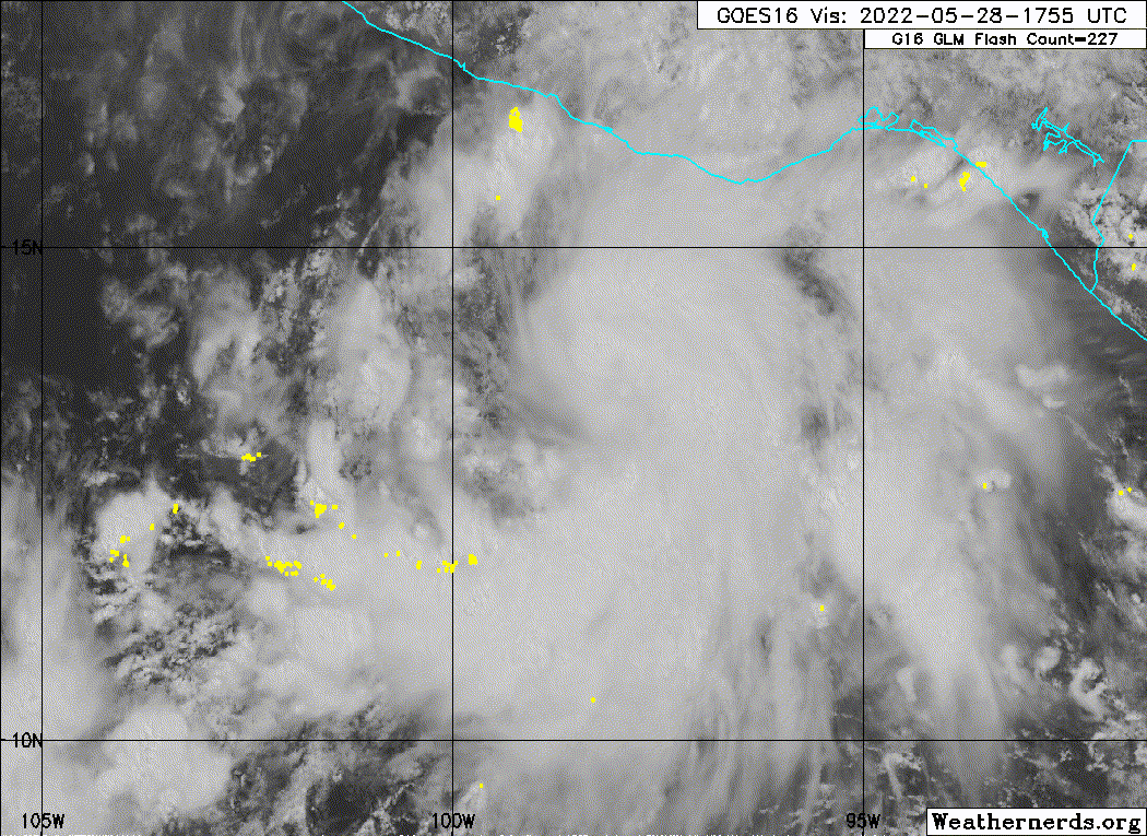
Agatha continues to gain strength. Satellite images show a
persistent central dense overcast feature and curved bands that
wrap about halfway around the center. An ASCAT-B pass from about
16Z showed peak winds of 40-45 kt. More recently, the Dvorak
classifications range from 45 to 55 kt. Based on all of this
satellite data, the initial intensity is increased to 50 kt.
The center of Agatha has been wobbling around for much of the day,
but the general motion has been north-northwestward at 4 kt. A
continued slow and erratic northwest or north motion is likely
through tonight, followed by a more steady northeastward motion on
Sunday as the storm becomes embedded in the flow between a ridge to
the east and a trough to its northwest. This slightly faster
northeastward motion should take Agatha to the coast of southern
Mexico by late Monday. Overall, the models have trended eastward
and the official forecast has been nudged in that direction.
All of the large-scale environmental factors (wind shear, moisture,
SST/heat content) are expected to be close to ideal for Agatha until
it reaches the coast. Accordingly, several of the rapid
intensification indices in the SHIPS model are higher than 70
percent. Due to these factors and probabilistic guidance, the NHC
intensity forecast remains at the high end of models and shows rapid
intensification occurring in the short term. Rapid weakening is
forecast after the storm makes landfall, and although the storm is
expected to dissipate over the rugged terrain of southern Mexico,
the remnants are likely to move over the southwestern Gulf and the
Yucatan Peninsula around the middle of next week.
Based on the current forecast, the government of Mexico has issued
hurricane and tropical storm warnings for southern Mexico.
Key Messages:
1. Hurricane conditions are expected in the hurricane warning area
in southern Mexico on Monday, with tropical storm conditions
beginning there Sunday night. Tropical storm conditions are
expected in the tropical storm warning area on Monday.
2. Heavy rains associated with Agatha will develop over portions of
southern Mexico by Sunday and continue through Tuesday. This will
pose a threat of potentially life-threatening flash flooding and
mudslides.
FORECAST POSITIONS AND MAX WINDS
INIT 28/2100Z 13.8N 98.1W 50 KT 60 MPH
12H 29/0600Z 14.0N 98.2W 65 KT 75 MPH
24H 29/1800Z 14.4N 98.0W 80 KT 90 MPH
36H 30/0600Z 14.9N 97.4W 90 KT 105 MPH
48H 30/1800Z 15.7N 96.5W 85 KT 100 MPH...INLAND
60H 31/0600Z 16.5N 95.4W 50 KT 60 MPH...INLAND
72H 31/1800Z 17.5N 94.5W 30 KT 35 MPH...INLAND
96H 01/1800Z...DISSIPATED
$$
Forecaster Cangialosi
Tropical Storm Agatha Advisory Number 4
NWS National Hurricane Center Miami FL EP012022
400 PM CDT Sat May 28 2022
...AGATHA GRADUALLY STRENGTHENING OFF SOUTHERN MEXICO...
...HURRICANE AND TROPICAL STORM WARNINGS ISSUED...
SUMMARY OF 400 PM CDT...2100 UTC...INFORMATION
----------------------------------------------
LOCATION...13.8N 98.1W
ABOUT 170 MI...270 KM SW OF PUERTO ANGEL MEXICO
MAXIMUM SUSTAINED WINDS...60 MPH...95 KM/H
PRESENT MOVEMENT...NNW OR 345 DEGREES AT 5 MPH...7 KM/H
MINIMUM CENTRAL PRESSURE...998 MB...29.47 INCHES
WATCHES AND WARNINGS
--------------------
CHANGES WITH THIS ADVISORY:
The government of Mexico has issued a Hurricane Warning from Salina
Cruz to Lagunas de Chacahua, a Tropical Storm Warning and Hurricane
Watch from Salina Cruz to Barra De Tonala, and a Tropical Storm
Warning from Barra De Tonala to Boca de Pijijiapan and from
Lagunas De Chacahua to Punta Maldonado
Tropical Storm Agatha Discussion Number 4
NWS National Hurricane Center Miami FL EP012022
400 PM CDT Sat May 28 2022
Agatha continues to gain strength. Satellite images show a
persistent central dense overcast feature and curved bands that
wrap about halfway around the center. An ASCAT-B pass from about
16Z showed peak winds of 40-45 kt. More recently, the Dvorak
classifications range from 45 to 55 kt. Based on all of this
satellite data, the initial intensity is increased to 50 kt.
The center of Agatha has been wobbling around for much of the day,
but the general motion has been north-northwestward at 4 kt. A
continued slow and erratic northwest or north motion is likely
through tonight, followed by a more steady northeastward motion on
Sunday as the storm becomes embedded in the flow between a ridge to
the east and a trough to its northwest. This slightly faster
northeastward motion should take Agatha to the coast of southern
Mexico by late Monday. Overall, the models have trended eastward
and the official forecast has been nudged in that direction.
All of the large-scale environmental factors (wind shear, moisture,
SST/heat content) are expected to be close to ideal for Agatha until
it reaches the coast. Accordingly, several of the rapid
intensification indices in the SHIPS model are higher than 70
percent. Due to these factors and probabilistic guidance, the NHC
intensity forecast remains at the high end of models and shows rapid
intensification occurring in the short term. Rapid weakening is
forecast after the storm makes landfall, and although the storm is
expected to dissipate over the rugged terrain of southern Mexico,
the remnants are likely to move over the southwestern Gulf and the
Yucatan Peninsula around the middle of next week.
Based on the current forecast, the government of Mexico has issued
hurricane and tropical storm warnings for southern Mexico.
Key Messages:
1. Hurricane conditions are expected in the hurricane warning area
in southern Mexico on Monday, with tropical storm conditions
beginning there Sunday night. Tropical storm conditions are
expected in the tropical storm warning area on Monday.
2. Heavy rains associated with Agatha will develop over portions of
southern Mexico by Sunday and continue through Tuesday. This will
pose a threat of potentially life-threatening flash flooding and
mudslides.
FORECAST POSITIONS AND MAX WINDS
INIT 28/2100Z 13.8N 98.1W 50 KT 60 MPH
12H 29/0600Z 14.0N 98.2W 65 KT 75 MPH
24H 29/1800Z 14.4N 98.0W 80 KT 90 MPH
36H 30/0600Z 14.9N 97.4W 90 KT 105 MPH
48H 30/1800Z 15.7N 96.5W 85 KT 100 MPH...INLAND
60H 31/0600Z 16.5N 95.4W 50 KT 60 MPH...INLAND
72H 31/1800Z 17.5N 94.5W 30 KT 35 MPH...INLAND
96H 01/1800Z...DISSIPATED
$$
Forecaster Cangialosi

0 likes
Visit the Caribbean-Central America Weather Thread where you can find at first post web cams,radars
and observations from Caribbean basin members Click Here
and observations from Caribbean basin members Click Here
-
Sciencerocks
- Category 5
- Posts: 7282
- Age: 38
- Joined: Thu Jul 06, 2017 1:51 am
-
Yellow Evan

- Professional-Met

- Posts: 15951
- Age: 25
- Joined: Fri Jul 15, 2011 12:48 pm
- Location: Henderson, Nevada/Honolulu, HI
- Contact:
-
cycloneye
- Admin
- Posts: 139041
- Age: 67
- Joined: Thu Oct 10, 2002 10:54 am
- Location: San Juan, Puerto Rico
Re: EPAC: AGATHA - Tropical Storm
0 likes
Visit the Caribbean-Central America Weather Thread where you can find at first post web cams,radars
and observations from Caribbean basin members Click Here
and observations from Caribbean basin members Click Here
-
cycloneye
- Admin
- Posts: 139041
- Age: 67
- Joined: Thu Oct 10, 2002 10:54 am
- Location: San Juan, Puerto Rico
Re: EPAC: AGATHA - Tropical Storm
000
WTPZ31 KNHC 282331
TCPEP1
BULLETIN
Tropical Storm Agatha Intermediate Advisory Number 4A
NWS National Hurricane Center Miami FL EP012022
700 PM CDT Sat May 28 2022
...AGATHA FORECAST TO BECOME A HURRICANE ON SUNDAY...
SUMMARY OF 700 PM CDT...0000 UTC...INFORMATION
----------------------------------------------
LOCATION...13.9N 98.4W
ABOUT 175 MI...280 KM SW OF PUERTO ANGEL MEXICO
MAXIMUM SUSTAINED WINDS...60 MPH...95 KM/H
PRESENT MOVEMENT...NNW OR 340 DEGREES AT 5 MPH...7 KM/H
MINIMUM CENTRAL PRESSURE...998 MB...29.47 INCHES
WATCHES AND WARNINGS
--------------------
CHANGES WITH THIS ADVISORY:
None
SUMMARY OF WATCHES AND WARNINGS IN EFFECT:
A Hurricane Warning is in effect for...
* Salina Cruz to Lagunas de Chacahua
A Hurricane Watch is in effect for...
* Salina Cruz eastward to Barra De Tonala
A Tropical Storm Warning is in effect for...
* Salina Cruz eastward to Boca de Pijijiapan
* Lagunas de Chacahua westward to Punta Maldonado
A Hurricane Warning means that hurricane conditions are expected
somewhere within the warning area within 36 hours. Preparations to
protect life and property should be rushed to completion.
A Hurricane Watch means that hurricane conditions are possible
within the watch area.
A Tropical Storm Warning means that tropical storm conditions are
expected somewhere within the warning area.
Interests elsewhere in southern Mexico should closely monitor the
progress of Agatha.
For storm information specific to your area, please monitor
products issued by your national meteorological service.
DISCUSSION AND OUTLOOK
----------------------
At 700 PM CDT (0000 UTC), the center of Tropical Storm Agatha was
re-located near latitude 13.9 North, longitude 98.4 West. Agatha is
moving toward the north-northwest near 5 mph (7 km/h). A turn
toward the northeast is forecast to occur late tonight or Sunday. On
the forecast track, the center of Agatha will approach the southern
coast of Mexico on Sunday and make landfall there on Monday.
Maximum sustained winds remain near 60 mph (95 km/h) with higher
gusts. Rapid intensification is forecast overnight, and Agatha
could become a hurricane on Sunday.
Tropical-storm-force winds extend outward up to 70 miles (110 km)
from the center.
The estimated minimum central pressure is 998 mb (29.47 inches).
HAZARDS AFFECTING LAND
----------------------
WIND: Hurricane conditions are expected in the hurricane warning
area and possible in the watch area on Monday, with tropical storm
conditions possible Sunday night. Tropical storm conditions are
expected in the tropical storm warning areas on Monday.
STORM SURGE: Storm surge is expected to produce significant coastal
flooding in areas of onshore winds near and to the east of where the
center of Agatha makes landfall. Near the coast, the surge will be
accompanied by large and destructive waves.
RAINFALL: Agatha will produce heavy rains over portions of southern
Mexico by Sunday into Tuesday night. The following rainfall amounts
are currently expected:
Mexican state of Oaxaca: 10 to 16 inches, with isolated maximum
amounts of 20 inches possible. Life-threatening flash flooding and
mudslides may occur.
Mexican state of Chiapas: 5 to 10 inches, with isolated maximum
amounts of 15 inches possible. Life-threatening flash flooding and
mudslides may occur.
Eastern portions of the Mexican state of Guerrero: 2 to 6 inches,
with isolated maximum amounts of 10 inches possible.
Life-threatening flash flooding and mudslides may occur.
Mexican states of Veracruz and Tabasco: 2 to 4 inches, with
isolated maximum amounts of 6 inches possible.
SURF: Swells generated by Agatha are expected to begin affecting
the coast of southern Mexico tonight. These swells are likely
to cause life-threatening surf and rip current conditions. Please
consult products from your local weather office.
NEXT ADVISORY
-------------
Next complete advisory at 1000 PM CDT.
$$
Forecaster Blake
0 likes
Visit the Caribbean-Central America Weather Thread where you can find at first post web cams,radars
and observations from Caribbean basin members Click Here
and observations from Caribbean basin members Click Here
-
hurricanes1234
- Category 5
- Posts: 2903
- Joined: Sat Jul 28, 2012 6:19 pm
- Location: Trinidad and Tobago
Re: EPAC: AGATHA - Tropical Storm
I guess this is our gentle reminder that it's a La Niña year. 
0 likes
PLEASE NOTE: With the exception of information from weather agencies that I may copy and paste here, my posts will NEVER be official, since I am NOT a meteorologist. They are solely my amateur opinion, and may or may not be accurate. Therefore, please DO NOT use them as official details, particularly when making important decisions. Thank you.
-
Yellow Evan
- Professional-Met
- Posts: 15951
- Age: 25
- Joined: Fri Jul 15, 2011 12:48 pm
- Location: Henderson, Nevada/Honolulu, HI
- Contact:
Re: EPAC: AGATHA - Tropical Storm
hurricanes1234 wrote:I guess this is our gentle reminder that it's a La Niña year.
More like a reminder that virtually TC with expectations goes through hiccups.
0 likes
-
Yellow Evan
- Professional-Met
- Posts: 15951
- Age: 25
- Joined: Fri Jul 15, 2011 12:48 pm
- Location: Henderson, Nevada/Honolulu, HI
- Contact:
-
skyline385

- Category 5
- Posts: 2444
- Age: 33
- Joined: Wed Aug 26, 2020 11:15 pm
- Location: Palm Beach County FL
Re: EPAC: AGATHA - Tropical Storm
hurricanes1234 wrote:I guess this is our gentle reminder that it's a La Niña year.
Think you are forgetting that we are still in May, it is already very hard to get a major going in May let alone one in the EPAC with a strong La Nina
2 likes
-
cycloneye
- Admin
- Posts: 139041
- Age: 67
- Joined: Thu Oct 10, 2002 10:54 am
- Location: San Juan, Puerto Rico
Re: EPAC: AGATHA - Tropical Storm
3.5
A. 01E (AGATHA)
B. 28/2330Z
C. 14.0N
D. 98.5W
E. THREE/GOES-E
F. T3.5/3.5
G. IR/EIR/VIS
H. REMARKS...7.5/10 BANDING YIELDS A DT OF 3.0. THE MET IS ALSO 3.0
BASED ON A RAPID DEVELOPMENT TREND OVER THE PAST 24 HOURS. THE PT IS
3.5. FT IS BASED ON PT SINCE A PATTERN ADJUSTMENT WAS MADE.
I. ADDL POSITIONS
NIL
...COVERDALE
0 likes
Visit the Caribbean-Central America Weather Thread where you can find at first post web cams,radars
and observations from Caribbean basin members Click Here
and observations from Caribbean basin members Click Here
-
DorkyMcDorkface

- Category 2

- Posts: 693
- Age: 26
- Joined: Mon Sep 30, 2019 1:32 pm
- Location: Mid-Atlantic
Re: EPAC: AGATHA - Tropical Storm
skyline385 wrote:hurricanes1234 wrote:I guess this is our gentle reminder that it's a La Niña year.
Think you are forgetting that we are still in May, it is already very hard to get a major going in May let alone one in the EPAC with a strong La Nina
Early season major hurricanes in the EPAC during La Niña really aren't all that uncommon. Celia 2010 is perhaps the best recent example of this: category 5 during the strongest Niña since the late 80's. Other examples include Carlotta 2000 (135kt C4) Adolph 2001 (C4) and Adrian 2011 (C4). EPAC is often able to produce strong storms timed with the passage of the MJO during La Niña early on before it begins to shut down and the Atlantic eventually takes over.
6 likes
Floyd 1999 | Isabel 2003 | Hanna 2008 | Irene 2011 | Sandy 2012 | Isaias 2020
-
Astromanía
- Category 2
- Posts: 737
- Age: 25
- Joined: Sat Aug 25, 2018 10:34 pm
- Location: Monterrey, N.L, México
Re: EPAC: AGATHA - Tropical Storm
DorkyMcDorkface wrote:skyline385 wrote:hurricanes1234 wrote:I guess this is our gentle reminder that it's a La Niña year.
Think you are forgetting that we are still in May, it is already very hard to get a major going in May let alone one in the EPAC with a strong La Nina
Early season major hurricanes in the EPAC during La Niña really aren't all that uncommon. Celia 2010 is perhaps the best recent example of this: category 5 during the strongest Niña since the late 80's. Other examples include Carlotta 2000 (135kt C4) Adolph 2001 (C4) and Adrian 2011 (C4). EPAC is often able to produce strong storms timed with the passage of the MJO during La Niña early on before it begins to shut down and the Atlantic eventually takes over.
Apparently people can't still differenciate between how EPAC and ATL works
1 likes
-
skyline385
- Category 5
- Posts: 2444
- Age: 33
- Joined: Wed Aug 26, 2020 11:15 pm
- Location: Palm Beach County FL
Re: EPAC: AGATHA - Tropical Storm
DorkyMcDorkface wrote:skyline385 wrote:hurricanes1234 wrote:I guess this is our gentle reminder that it's a La Niña year.
Think you are forgetting that we are still in May, it is already very hard to get a major going in May let alone one in the EPAC with a strong La Nina
Early season major hurricanes in the EPAC during La Niña really aren't all that uncommon. Celia 2010 is perhaps the best recent example of this: category 5 during the strongest Niña since the late 80's. Other examples include Carlotta 2000 (135kt C4) Adolph 2001 (C4) and Adrian 2011 (C4). EPAC is often able to produce strong storms timed with the passage of the MJO during La Niña early on before it begins to shut down and the Atlantic eventually takes over.
Thanks for the detailed write-up, I haven't paid a lot of attention to past EPAC season and wasn't aware of this. My bad
1 likes
-
KirbyDude25

- Tropical Storm

- Posts: 116
- Age: 19
- Joined: Mon Sep 20, 2021 8:03 am
Re: EPAC: AGATHA - Tropical Storm
18Z HWRF and HMON dropped recently with similar results. 112kt peak from HWRF, 86kt from HMON. However, both of them not only have Agatha reforming in the Gulf, but they have that storm becoming a 70kt hurricane and hitting the other side of Mexico. Has this happened recently?
0 likes
New Jersey, Rutgers '27
Irene 2011 | Sandy 2012 | Fay 2020 | Isaias 2020 | Ida 2021
Irene 2011 | Sandy 2012 | Fay 2020 | Isaias 2020 | Ida 2021
-
Yellow Evan
- Professional-Met
- Posts: 15951
- Age: 25
- Joined: Fri Jul 15, 2011 12:48 pm
- Location: Henderson, Nevada/Honolulu, HI
- Contact:
Re: EPAC: AGATHA - Tropical Storm

Mid-level eye but westerly shear still resulting in a tilt of the vortex most likely.
1 likes
-
ouragans

- Category 1

- Posts: 465
- Age: 52
- Joined: Sun Jun 12, 2011 12:09 pm
- Location: Abymes, Guadeloupe F.W.I
- Contact:
Re: EPAC: AGATHA - Tropical Storm
0 likes
Personal forecast disclaimer
This post is a personal point of view, not an information. Please refer to official statements for life-threatening decisions.
David '79, Frederic '79, Hugo '89, Iris, Luis & Marilyn '95, Georges '98, Lenny '99, Dean '07, Irma '17, Maria '17, Fiona '22, Philippe '23, Tammy '23
16°13'33.3,"6N -61°36'39.5"W
-
cycloneye
- Admin
- Posts: 139041
- Age: 67
- Joined: Thu Oct 10, 2002 10:54 am
- Location: San Juan, Puerto Rico
Re: EPAC: AGATHA - Tropical Storm
I posted the TCPOD this morning but no problen as it is a fresh reminder of the Sunday's mission.
2 likes
Visit the Caribbean-Central America Weather Thread where you can find at first post web cams,radars
and observations from Caribbean basin members Click Here
and observations from Caribbean basin members Click Here
-
hurricanes1234
- Category 5
- Posts: 2903
- Joined: Sat Jul 28, 2012 6:19 pm
- Location: Trinidad and Tobago
Re: EPAC: AGATHA - Tropical Storm
DorkyMcDorkface wrote:skyline385 wrote:hurricanes1234 wrote:I guess this is our gentle reminder that it's a La Niña year.
Think you are forgetting that we are still in May, it is already very hard to get a major going in May let alone one in the EPAC with a strong La Nina
Early season major hurricanes in the EPAC during La Niña really aren't all that uncommon. Celia 2010 is perhaps the best recent example of this: category 5 during the strongest Niña since the late 80's. Other examples include Carlotta 2000 (135kt C4) Adolph 2001 (C4) and Adrian 2011 (C4). EPAC is often able to produce strong storms timed with the passage of the MJO during La Niña early on before it begins to shut down and the Atlantic eventually takes over.
That's true, I completely forgot about those examples. Apologies for the confusion.
Whatever becomes of this, I just hope that it doesn't cause much damage and loss of life. To have a hurricane strike your area so early in the season is scary, especially given the conducive environment that surrounds it.
0 likes
PLEASE NOTE: With the exception of information from weather agencies that I may copy and paste here, my posts will NEVER be official, since I am NOT a meteorologist. They are solely my amateur opinion, and may or may not be accurate. Therefore, please DO NOT use them as official details, particularly when making important decisions. Thank you.
Who is online
Users browsing this forum: No registered users and 21 guests