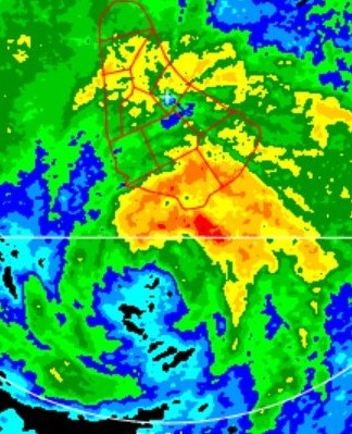
EPAC: BONNIE - Post-Tropical - Discussion

Moderator: S2k Moderators

Message
Author
User avatar
Kingarabian
S2K Supporter
S2K Supporter
Posts: 15434
Joined: Sat Aug 08, 2009 3:06 am
Location: Honolulu, Hawaii

Re: ATL: INVEST 94L - Discussion

#201 Postby Kingarabian » Mon Jun 27, 2022 12:39 pm

MississippiWx wrote:
Kingarabian wrote:40kt winds so far found by Recon. Just need a circulation.


Enhanced by trade winds. It’s usually easy to find tropical storm force winds in these disturbances thanks to the trades on the north side. I don’t see it having an organized low yet, just judging by satellite.

Agreed. Just need recon to uh... actually breach the suspected center to see what we have though.
1 likes   
RIP Kobe Bryant

User avatar
cycloneye
Admin
Admin
Posts: 139062
Age: 67
Joined: Thu Oct 10, 2002 10:54 am
Location: San Juan, Puerto Rico

Re: ATL: INVEST 94L - Discussion

#202 Postby cycloneye » Mon Jun 27, 2022 12:49 pm

Central Tropical Atlantic:
A tropical wave located about 700 miles east-southeast of the
southern Windward Islands is producing a large area of showers and
thunderstorms. Environmental conditions appear conducive for
development, and a tropical depression or a tropical storm is likely
to form during the next day or so before the system reaches the
Windward Islands Tuesday night or possibly while moving westward
across the southern Caribbean Sea Wednesday through Friday. A NOAA
Hurricane Hunter aircraft is currently investigating the system and
has found winds to tropical storm force. Interests in the Windward
Islands and along the northeastern coast of Venezuela should monitor
the progress of this system, and tropical storm watches or warnings
could be required for portions of these areas later today.
Regardless of development, locally heavy rainfall is possible over
the Windward Islands and the northeastern coast of Venezuela Tuesday
night and Wednesday.
* Formation chance through 48 hours...high...70 percent.
* Formation chance through 5 days...high...90 percent.
0 likes   
Visit the Caribbean-Central America Weather Thread where you can find at first post web cams,radars
and observations from Caribbean basin members Click Here

User avatar
cheezyWXguy
Category 5
Category 5
Posts: 5528
Joined: Mon Feb 13, 2006 12:29 am
Location: Dallas, TX

Re: ATL: INVEST 94L - Discussion

#203 Postby cheezyWXguy » Mon Jun 27, 2022 1:14 pm

I doubt recon is going to find a tight closed circulation at this point, judging by satellite. However, that big inflow channel from the SW on the southeastern side, makes me think thats the portion of the disturbance where it will eventually occur.
0 likes   

User avatar
Kingarabian
S2K Supporter
S2K Supporter
Posts: 15434
Joined: Sat Aug 08, 2009 3:06 am
Location: Honolulu, Hawaii

Re: ATL: INVEST 94L - Discussion

#204 Postby Kingarabian » Mon Jun 27, 2022 1:17 pm

0 likes   
RIP Kobe Bryant

User avatar
wxman57
Moderator-Pro Met
Moderator-Pro Met
Posts: 22480
Age: 66
Joined: Sat Jun 21, 2003 8:06 pm
Location: Houston, TX (southwest)

Re: ATL: INVEST 94L - Discussion

#205 Postby wxman57 » Mon Jun 27, 2022 1:46 pm

Whether it is called 94L, PTC Two, or Bonnie, the effects will be the same as it reaches the islands. Some 35kt sustained wind on the north side and about 15kts south of the track. Periods of heavy rain and squalls for Trinidad and Tobago tomorrow afternoon through Wednesday morning as it passes. It will have a hard time generating or maintaining an LLC as it races west along the coast of SA Wed/Thu. Best chance of strengthening is Friday in the SW Caribbean, prior to moving inland into Nicaragua and dissipating there.
3 likes   

Weatherwatcher2018
Tropical Depression
Tropical Depression
Posts: 65
Joined: Wed Sep 26, 2018 4:30 pm

Re: ATL: INVEST 94L - Discussion

#206 Postby Weatherwatcher2018 » Mon Jun 27, 2022 2:02 pm

wxman57 wrote:Whether it is called 94L, PTC Two, or Bonnie, the effects will be the same as it reaches the islands. Some 35kt sustained wind on the north side and about 15kts south of the track. Periods of heavy rain and squalls for Trinidad and Tobago tomorrow afternoon through Wednesday morning as it passes. It will have a hard time generating or maintaining an LLC as it races west along the coast of SA Wed/Thu. Best chance of strengthening is Friday in the SW Caribbean, prior to moving inland into Nicaragua and dissipating there.


Any impacts for Barbados ? It’s pouring here currently and a bit windy
1 likes   

User avatar
ouragans
Category 1
Category 1
Posts: 465
Age: 52
Joined: Sun Jun 12, 2011 12:09 pm
Location: Abymes, Guadeloupe F.W.I
Contact:

Re: ATL: INVEST 94L - Discussion

#207 Postby ouragans » Mon Jun 27, 2022 2:19 pm

Weatherwatcher2018 wrote:
wxman57 wrote:Whether it is called 94L, PTC Two, or Bonnie, the effects will be the same as it reaches the islands. Some 35kt sustained wind on the north side and about 15kts south of the track. Periods of heavy rain and squalls for Trinidad and Tobago tomorrow afternoon through Wednesday morning as it passes. It will have a hard time generating or maintaining an LLC as it races west along the coast of SA Wed/Thu. Best chance of strengthening is Friday in the SW Caribbean, prior to moving inland into Nicaragua and dissipating there.


Any impacts for Barbados ? It’s pouring here currently and a bit windy

94L is 720 miles away from Barbados, not expected before tomorrow. It cannot be that
1 likes   
Personal forecast disclaimer
This post is a personal point of view, not an information. Please refer to official statements for life-threatening decisions.

David '79, Frederic '79, Hugo '89, Iris, Luis & Marilyn '95, Georges '98, Lenny '99, Dean '07, Irma '17, Maria '17, Fiona '22, Philippe '23, Tammy '23
16°13'33.3,"6N -61°36'39.5"W

User avatar
NDG
S2K Supporter
S2K Supporter
Posts: 14933
Joined: Sun Jul 09, 2006 10:14 pm
Location: Orlando, FL

Re: ATL: INVEST 94L - Discussion

#208 Postby NDG » Mon Jun 27, 2022 2:21 pm

Recon so far only shows a sharp trough of low pressure, no defined LLC.
0 likes   

User avatar
wxman57
Moderator-Pro Met
Moderator-Pro Met
Posts: 22480
Age: 66
Joined: Sat Jun 21, 2003 8:06 pm
Location: Houston, TX (southwest)

Re: ATL: INVEST 94L - Discussion

#209 Postby wxman57 » Mon Jun 27, 2022 2:27 pm

As expected, no LLC. Small eddy way to the south. Tropical waves can easily product 35-45 kt winds on the north side, particularly when they're moving quickly westward.
0 likes   

User avatar
Kingarabian
S2K Supporter
S2K Supporter
Posts: 15434
Joined: Sat Aug 08, 2009 3:06 am
Location: Honolulu, Hawaii

Re: ATL: INVEST 94L - Discussion

#210 Postby Kingarabian » Mon Jun 27, 2022 2:30 pm

Theres a couple of rotating areas within the envelope.
2 likes   
RIP Kobe Bryant

User avatar
Stormybajan
Category 1
Category 1
Posts: 428
Joined: Thu May 20, 2021 3:21 pm
Location: Windward Islands

Re: ATL: INVEST 94L - Discussion

#211 Postby Stormybajan » Mon Jun 27, 2022 2:37 pm

Weatherwatcher2018 wrote:
wxman57 wrote:Whether it is called 94L, PTC Two, or Bonnie, the effects will be the same as it reaches the islands. Some 35kt sustained wind on the north side and about 15kts south of the track. Periods of heavy rain and squalls for Trinidad and Tobago tomorrow afternoon through Wednesday morning as it passes. It will have a hard time generating or maintaining an LLC as it races west along the coast of SA Wed/Thu. Best chance of strengthening is Friday in the SW Caribbean, prior to moving inland into Nicaragua and dissipating there.


Any impacts for Barbados ? It’s pouring here currently and a bit windy


Honestly after seeing it yesterday and very early this morning I was beginning to doubt much would happen with 94L PRE-islands but its trying to atleast break free of the ITCZ right now and convection has been maintained throughout the entire day, DMAX should spark it off as it nears 52 W tonight. For us in Barbados 94L seems to be a bit south for us to get any serious RAIN impacts but as recon showed it looks like the strongest winds are on the northern side of the wave's envelope so I think we should expect some gusty winds starting tomorrow night and for most of Wednesday imo. The one behind 94L might be more of a rain event for us :double:
2 likes   
Sad West Indies and Manchester United fan ⚽️

User avatar
AtlanticWind
S2K Supporter
S2K Supporter
Posts: 1805
Age: 65
Joined: Sun Aug 08, 2004 9:57 pm
Location: Plantation,Fla

Re: ATL: INVEST 94L - Discussion

#212 Postby AtlanticWind » Mon Jun 27, 2022 3:11 pm

PTC 2 according to nhc

Advisories At 5pm
0 likes   

User avatar
cycloneye
Admin
Admin
Posts: 139062
Age: 67
Joined: Thu Oct 10, 2002 10:54 am
Location: San Juan, Puerto Rico

Re: ATL: INVEST 94L - Discussion

#213 Postby cycloneye » Mon Jun 27, 2022 3:12 pm

4 likes   
Visit the Caribbean-Central America Weather Thread where you can find at first post web cams,radars
and observations from Caribbean basin members Click Here

User avatar
cycloneye
Admin
Admin
Posts: 139062
Age: 67
Joined: Thu Oct 10, 2002 10:54 am
Location: San Juan, Puerto Rico

Re: ATL: TWO - Potential Tropical Cyclone - Discussion

#214 Postby cycloneye » Mon Jun 27, 2022 3:51 pm

Image
4 likes   
Visit the Caribbean-Central America Weather Thread where you can find at first post web cams,radars
and observations from Caribbean basin members Click Here

Jelmergraaff
Tropical Storm
Tropical Storm
Posts: 127
Age: 21
Joined: Fri Aug 27, 2021 1:00 pm
Location: The Netherlands

Re: ATL: TWO - Potential Tropical Cyclone - Discussion

#215 Postby Jelmergraaff » Mon Jun 27, 2022 3:54 pm


Hey, I'm back after some time. I have been following everything for a bit and I'm quite surprised the NHC is already forecasting it to get to hurricane strength. Even if it's just because of the rarity of these storms (time of year in combination with the region of development). It would be quite spectacular.

Yesterday I had to work and wrote an article about it for a Dutch weather websit. Got some nice responses, even many of the weather amateurs here didn't know tropical storms developing in this area in June are rare. https://www.weer.nl/nieuws/2022/waarschijnlijk-zeldzame-tropische-depressie-op-de-atlantische-oceaan
Last edited by Jelmergraaff on Mon Jun 27, 2022 3:56 pm, edited 1 time in total.
2 likes   
20-year old meteorologist from The Netherlands. Interested in all fields of meteorology, including tropical systems like hurricanes.

User avatar
Category5Kaiju
Category 5
Category 5
Posts: 3355
Age: 22
Joined: Thu Dec 24, 2020 12:45 pm
Location: Seattle

Re: ATL: TWO - Potential Tropical Cyclone - Discussion

#216 Postby Category5Kaiju » Mon Jun 27, 2022 3:55 pm

It's almost surreal to see the forecast cone with an "H" near Nicaragua, given the last time I saw an "H" headed toward that country was in November of 2020. While this storm will almost certainly not be as strong, it sure brings back interesting tracking memories.
2 likes   
Unless explicitly stated, all information covered in my posts is based on my opinions and observations. Please refer to a professional meteorologist or an accredited weather research agency otherwise, especially if serious decisions must be made in the event of a potentially life-threatening tropical storm or hurricane.

User avatar
Kingarabian
S2K Supporter
S2K Supporter
Posts: 15434
Joined: Sat Aug 08, 2009 3:06 am
Location: Honolulu, Hawaii

Re: ATL: TWO - Potential Tropical Cyclone - Discussion

#217 Postby Kingarabian » Mon Jun 27, 2022 3:56 pm

Since there's no well defined LLC and its possibly two broad circulations rotating around each other, the track might shift.
0 likes   
RIP Kobe Bryant

tolakram
Admin
Admin
Posts: 19165
Age: 60
Joined: Sun Aug 27, 2006 8:23 pm
Location: Florence, KY (name is Mark)

Re: ATL: TWO - Potential Tropical Cyclone - Discussion

#218 Postby tolakram » Mon Jun 27, 2022 3:59 pm

I'm surprised at expected hurricane strength. They have the better modeling tools that maybe shows something we can't see. Latest euro shows a quick crossover into the EPAC, which is interesting.
0 likes   
M a r k
- - - - -
Join us in chat: Storm2K Chatroom Invite. Android and IOS apps also available.

The posts in this forum are NOT official forecasts and should not be used as such. Posts are NOT endorsed by any professional institution or STORM2K.org. For official information and forecasts, please refer to NHC and NWS products.

MarioProtVI
Category 2
Category 2
Posts: 670
Age: 22
Joined: Sun Sep 29, 2019 7:33 pm
Location: New Jersey

Re: ATL: TWO - Potential Tropical Cyclone - Discussion

#219 Postby MarioProtVI » Mon Jun 27, 2022 4:01 pm


This really wants to be Cesar-Douglas 1996 2.0 it seems.
0 likes   

Jelmergraaff
Tropical Storm
Tropical Storm
Posts: 127
Age: 21
Joined: Fri Aug 27, 2021 1:00 pm
Location: The Netherlands

Re: ATL: TWO - Potential Tropical Cyclone - Discussion

#220 Postby Jelmergraaff » Mon Jun 27, 2022 4:01 pm

Kingarabian wrote:Since there's no well defined LLC and its possibly two broad circulations rotating around each other, the track might shift.


I figure that could be quite important. It would of course make quite a difference in terms of strengthening potential whether the center stays over water or that it just crosses over the South-American coast. That probably makes the intensity forecast rather uncertain.
0 likes   
20-year old meteorologist from The Netherlands. Interested in all fields of meteorology, including tropical systems like hurricanes.


Return to “2022”

Who is online

Users browsing this forum: No registered users and 61 guests