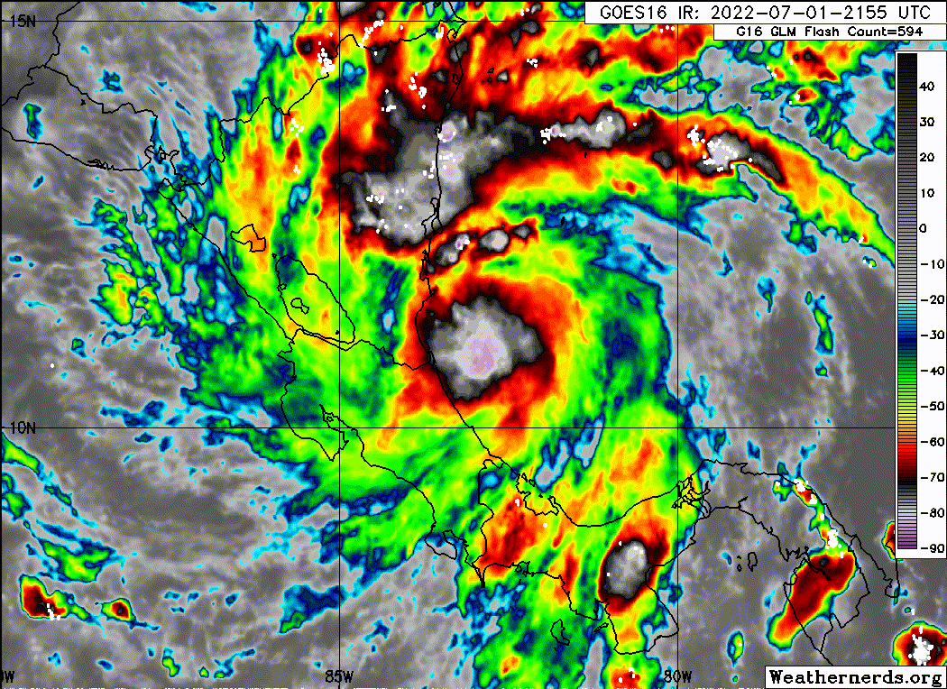
EPAC: BONNIE - Post-Tropical - Discussion

Moderator: S2k Moderators

Message
Author
User avatar
aspen
Category 5
Category 5
Posts: 8056
Joined: Sat Oct 12, 2019 7:10 pm
Location: Connecticut, USA

Re: ATL: BONNIE - Tropical Storm - Discussion

#501 Postby aspen » Fri Jul 01, 2022 7:33 pm

skyline385 wrote:
aspen wrote:There’s a large expanding hot tower of <-80C convection over Bonnie’s tiny core. The next pass might be a few mbar lower.

This structure would’ve been ripe for RI into a major (or close to one) if Bonnie had formed a day or two ago. CA dodged a potentially large bullet this time.

You were right, almost 2.5mb drop in 50 mins

https://uploads.tapatalk-cdn.com/20220702/b9e0a6b5eb3cd5bed6876505240970de.jpg

Looks like this pass (and some additional data) supports 45-50 kt and 996-997mb. This might get to high end TS status before landfall.
0 likes   
Irene '11 Sandy '12 Hermine '16 5/15/2018 Derecho Fay '20 Isaias '20 Elsa '21 Henri '21 Ida '21

I am only a meteorology enthusiast who knows a decent amount about tropical cyclones. Look to the professional mets, the NHC, or your local weather office for the best information.

User avatar
skyline385
Category 5
Category 5
Posts: 2444
Age: 33
Joined: Wed Aug 26, 2020 11:15 pm
Location: Palm Beach County FL

Re: ATL: BONNIE - Tropical Storm - Discussion

#502 Postby skyline385 » Fri Jul 01, 2022 7:52 pm

1 likes   

Sciencerocks
Category 5
Category 5
Posts: 7282
Age: 38
Joined: Thu Jul 06, 2017 1:51 am

Re: ATL: BONNIE - Tropical Storm - Discussion

#503 Postby Sciencerocks » Fri Jul 01, 2022 8:23 pm

Image
1 likes   

User avatar
aspen
Category 5
Category 5
Posts: 8056
Joined: Sat Oct 12, 2019 7:10 pm
Location: Connecticut, USA

Re: ATL: BONNIE - Tropical Storm - Discussion

#504 Postby aspen » Fri Jul 01, 2022 9:25 pm

You could argue that Bonnie is a 50 kt TS right now, or will be one at landfall. Looks like its pressure has stabilized at 997mb, though.

Do we know if there will be any recon flights once it’s in the EPac? It’ll remain relatively close to Mexico, and it would be great to have recon coverage if it tries to rapidly intensify again.
0 likes   
Irene '11 Sandy '12 Hermine '16 5/15/2018 Derecho Fay '20 Isaias '20 Elsa '21 Henri '21 Ida '21

I am only a meteorology enthusiast who knows a decent amount about tropical cyclones. Look to the professional mets, the NHC, or your local weather office for the best information.

MarioProtVI
Category 2
Category 2
Posts: 669
Age: 22
Joined: Sun Sep 29, 2019 7:33 pm
Location: New Jersey

Re: ATL: BONNIE - Tropical Storm - Discussion

#505 Postby MarioProtVI » Fri Jul 01, 2022 9:58 pm

And we have landfall. 50/997, but could’ve been worse had it gotten its act together a day or two ago, given the fact it looked like it was right on the verge of beginning to intensify quickly looking at the satellite and microwave data.
0 likes   

User avatar
cycloneye
Admin
Admin
Posts: 139025
Age: 67
Joined: Thu Oct 10, 2002 10:54 am
Location: San Juan, Puerto Rico

Re: ATL: BONNIE - Tropical Storm - Discussion

#506 Postby cycloneye » Fri Jul 01, 2022 10:15 pm

Have a question about the ACE. When Bonnie is in the Pacific, will the ACE count continue for the North Atlantic or will be for EPAC?
0 likes   
Visit the Caribbean-Central America Weather Thread where you can find at first post web cams,radars
and observations from Caribbean basin members Click Here

User avatar
galaxy401
Category 5
Category 5
Posts: 2298
Age: 28
Joined: Sat Aug 25, 2012 9:04 pm
Location: Casa Grande, Arizona

Re: ATL: BONNIE - Tropical Storm - Discussion

#507 Postby galaxy401 » Fri Jul 01, 2022 10:19 pm

cycloneye wrote:Have a question about the ACE. When Bonnie is in the Pacific, will the ACE count continue for the North Atlantic or will be for EPAC?

Since it's in the EPAC, I imagine they will add the ACE for that respective basin.
0 likes   
Got my eyes on moving right into Hurricane Alley: Florida.

Hurricane Mike
Category 2
Category 2
Posts: 562
Joined: Tue Apr 10, 2018 7:44 am

Re: ATL: BONNIE - Tropical Storm - Discussion

#508 Postby Hurricane Mike » Fri Jul 01, 2022 10:48 pm

We have landfall! Looks like she was forming an eye.
https://www.youtube.com/watch?v=XN5-J4xFovA
0 likes   

NXStumpy_Robothing
Category 1
Category 1
Posts: 325
Age: 23
Joined: Fri Jun 05, 2020 11:50 pm
Location: North Georgia

Re: ATL: BONNIE - Tropical Storm - Discussion

#509 Postby NXStumpy_Robothing » Fri Jul 01, 2022 10:51 pm

Kind of surprised they didn't go 50kt given the 61kt FL recorded at 850 mb (which would translate to about 50kt at the surface) and the multiple unflagged SFMR readings between 45 and 50kt. Plus, it seemed that the storm was still improving in terms of organization, even if pressure drops temporarily slowed down. Might be something that gets a second look in the TCR.

Given how warm Lake Nicaragua is and how narrow the land that the storm is crossing (plus how relatively low topography-wise compared to the rest of Central America it is), I wouldn't be shocked to see this remain a TS all the way into the East Pacific. Had the system received another 12 hours or so over water this would've been a hurricane. Hopefully, this system will cooperate for once and stay away from land once it becomes a hurricane in the Pacific; the environment and the SSTs are both generally favorable for the next 2-3 days out there.
2 likes   
Undergraduate Meteorology Student, Georgia Institute of Technology

User avatar
AtlanticWind
S2K Supporter
S2K Supporter
Posts: 1805
Age: 65
Joined: Sun Aug 08, 2004 9:57 pm
Location: Plantation,Fla

Re: ATL: BONNIE - Tropical Storm - Discussion

#510 Postby AtlanticWind » Fri Jul 01, 2022 11:12 pm

Ok Bonnie leave us for the Pacific ocean .. see if we care. :rarrow:
3 likes   

MarioProtVI
Category 2
Category 2
Posts: 669
Age: 22
Joined: Sun Sep 29, 2019 7:33 pm
Location: New Jersey

Re: ATL: BONNIE - Tropical Storm - Discussion

#511 Postby MarioProtVI » Fri Jul 01, 2022 11:20 pm

NXStumpy_Robothing wrote:Kind of surprised they didn't go 50kt given the 61kt FL recorded at 850 mb (which would translate to about 50kt at the surface) and the multiple unflagged SFMR readings between 45 and 50kt. Plus, it seemed that the storm was still improving in terms of organization, even if pressure drops temporarily slowed down. Might be something that gets a second look in the TCR.

Given how warm Lake Nicaragua is and how narrow the land that the storm is crossing (plus how relatively low topography-wise compared to the rest of Central America it is), I wouldn't be shocked to see this remain a TS all the way into the East Pacific. Had the system received another 12 hours or so over water this would've been a hurricane. Hopefully, this system will cooperate for once and stay away from land once it becomes a hurricane in the Pacific; the environment and the SSTs are both generally favorable for the next 2-3 days out there.

Their wording in the recent discussion suggests they may up the landfall intensity to 50 kt in post-analysis.
1 likes   

User avatar
AnnularCane
S2K Supporter
S2K Supporter
Posts: 2634
Joined: Thu Jun 08, 2006 9:18 am
Location: Wytheville, VA

Re: ATL: BONNIE - Tropical Storm - Discussion

#512 Postby AnnularCane » Fri Jul 01, 2022 11:44 pm

AtlanticWind wrote:Ok Bonnie leave us for the Pacific ocean .. see if we care. :rarrow:


The Atlantic has too much land. :P
2 likes   
"But it never rained rain. It never snowed snow. And it never blew just wind. It rained things like soup and juice. It snowed mashed potatoes and green peas. And sometimes the wind blew in storms of hamburgers." -- Judi Barrett, Cloudy with a Chance of Meatballs

CrazyC83
Professional-Met
Professional-Met
Posts: 33393
Joined: Tue Mar 07, 2006 11:57 pm
Location: Deep South, for the first time!

Re: ATL: BONNIE - Tropical Storm - Discussion

#513 Postby CrazyC83 » Sat Jul 02, 2022 12:36 am

Score one for the models the last few days. They correctly predicted a storm that would struggle until approach, then rapidly intensify. I agree that 50 kt was likely the intensity at landfall, and if it had 12 more hours it likely would have become a hurricane.
3 likes   

User avatar
Category5Kaiju
Category 5
Category 5
Posts: 3351
Age: 22
Joined: Thu Dec 24, 2020 12:45 pm
Location: Seattle

Re: ATL: BONNIE - Tropical Storm - Discussion

#514 Postby Category5Kaiju » Sat Jul 02, 2022 2:01 am

Interestingly, this likely will not be the first time a crossover storm becomes more powerful in its non-native basin; we saw this with Cesar, which would have kept its name and go on to become a Cat 4 hurricane in the EPAC had the current naming rules applied back then.

I'm also still waiting for the future season where an EPAC-named system survives a crossover into the Atlantic and then becomes a monster in the Atlantic and a retirement-worthy name, haha. I think that would hypothetically and arguably be one of the strangest and most memorable things to ever see, at least for those who predominantly love to track Atlantic systems lol
0 likes   
Unless explicitly stated, all information covered in my posts is based on my opinions and observations. Please refer to a professional meteorologist or an accredited weather research agency otherwise, especially if serious decisions must be made in the event of a potentially life-threatening tropical storm or hurricane.

User avatar
galaxy401
Category 5
Category 5
Posts: 2298
Age: 28
Joined: Sat Aug 25, 2012 9:04 pm
Location: Casa Grande, Arizona

Re: ATL: BONNIE - Tropical Storm - Discussion

#515 Postby galaxy401 » Sat Jul 02, 2022 2:39 am

Category5Kaiju wrote:Interestingly, this likely will not be the first time a crossover storm becomes more powerful in its non-native basin; we saw this with Cesar, which would have kept its name and go on to become a Cat 4 hurricane in the EPAC had the current naming rules applied back then.

I'm also still waiting for the future season where an EPAC-named system survives a crossover into the Atlantic and then becomes a monster in the Atlantic and a retirement-worthy name, haha. I think that would hypothetically and arguably be one of the strangest and most memorable things to ever see, at least for those who predominantly love to track Atlantic systems lol

Hermine in 2010 was the closest it got. Formed as a TD in the Pacific then became a strong tropical storm in the Atlantic. It actually did decent damage but not enough for retirement.
0 likes   
Got my eyes on moving right into Hurricane Alley: Florida.

User avatar
cycloneye
Admin
Admin
Posts: 139025
Age: 67
Joined: Thu Oct 10, 2002 10:54 am
Location: San Juan, Puerto Rico

Re: ATL: BONNIE - Tropical Storm - Discussion

#516 Postby cycloneye » Sat Jul 02, 2022 6:21 am

Will retain the name and ACE will count for North Atlantic.

It is worth mentioning that Bonnie's low-level circulation is
expected to survive its passage across Central America, similar to
that of Hurricane Otto back in 2016. Thus, the system is expected to
retain its name even after it moves into the far eastern Pacific
later today. The intermediate advisory at 1200 UTC will be issued
under the same Atlantic header as before. Product headers will
change to eastern Pacific headers beginning with the next complete
advisory at 1500 UTC, with the ATCF identifier changing from
AL022022 to EP042022.
0 likes   
Visit the Caribbean-Central America Weather Thread where you can find at first post web cams,radars
and observations from Caribbean basin members Click Here

SteveM
Tropical Depression
Tropical Depression
Posts: 72
Joined: Wed Jul 22, 2020 8:21 am

Re: ATL: BONNIE - Tropical Storm - Discussion

#517 Postby SteveM » Sat Jul 02, 2022 6:34 am

cycloneye wrote:Will retain the name and ACE will count for North Atlantic.

It is worth mentioning that Bonnie's low-level circulation is
expected to survive its passage across Central America, similar to
that of Hurricane Otto back in 2016. Thus, the system is expected to
retain its name even after it moves into the far eastern Pacific
later today. The intermediate advisory at 1200 UTC will be issued
under the same Atlantic header as before. Product headers will
change to eastern Pacific headers beginning with the next complete
advisory at 1500 UTC, with the ATCF identifier changing from
AL022022 to EP042022.


Can't see anything regarding ACE in the quote there, am I missing something? Would be strange for ACE to count for the ATL when it's in the EPAC.
4 likes   

User avatar
aspen
Category 5
Category 5
Posts: 8056
Joined: Sat Oct 12, 2019 7:10 pm
Location: Connecticut, USA

Re: ATL: BONNIE - Tropical Storm - Discussion

#518 Postby aspen » Sat Jul 02, 2022 6:44 am

There’s a chance that Bonnie could end up as the strongest EPac storm so far (or maybe for the entire season if the higher end intensity forecasts verify), which would be funny because it’s the one EPac system not from the EPac.
0 likes   
Irene '11 Sandy '12 Hermine '16 5/15/2018 Derecho Fay '20 Isaias '20 Elsa '21 Henri '21 Ida '21

I am only a meteorology enthusiast who knows a decent amount about tropical cyclones. Look to the professional mets, the NHC, or your local weather office for the best information.

tolakram
Admin
Admin
Posts: 19165
Age: 60
Joined: Sun Aug 27, 2006 8:23 pm
Location: Florence, KY (name is Mark)

Re: EPAC: BONNIE - Tropical Storm - Discussion

#519 Postby tolakram » Sat Jul 02, 2022 7:20 am

The way I read it the Atlantic will get the ACE until the header changes to EPAC, at which time all new ACE will go towards the EPAC.
0 likes   
M a r k
- - - - -
Join us in chat: Storm2K Chatroom Invite. Android and IOS apps also available.

The posts in this forum are NOT official forecasts and should not be used as such. Posts are NOT endorsed by any professional institution or STORM2K.org. For official information and forecasts, please refer to NHC and NWS products.

User avatar
cycloneye
Admin
Admin
Posts: 139025
Age: 67
Joined: Thu Oct 10, 2002 10:54 am
Location: San Juan, Puerto Rico

Re: EPAC: BONNIE - Tropical Storm - Discussion

#520 Postby cycloneye » Sat Jul 02, 2022 7:58 am

Officially in EPAC.

EP, 04, 2022070212, , BEST, 0, 112N, 858W, 35, 1000, TS
4 likes   
Visit the Caribbean-Central America Weather Thread where you can find at first post web cams,radars
and observations from Caribbean basin members Click Here


Return to “2022”

Who is online

Users browsing this forum: No registered users and 24 guests