https://twitter.com/FLweather_wx/status/1541912685381558273
EPAC: BONNIE - Post-Tropical - Discussion
Moderator: S2k Moderators
-
cycloneye

- Admin

- Posts: 139025
- Age: 67
- Joined: Thu Oct 10, 2002 10:54 am
- Location: San Juan, Puerto Rico
Re: ATL: TWO - Potential Tropical Cyclone - Discussion
0 likes
Visit the Caribbean-Central America Weather Thread where you can find at first post web cams,radars
and observations from Caribbean basin members Click Here
and observations from Caribbean basin members Click Here
-
cycloneye
- Admin
- Posts: 139025
- Age: 67
- Joined: Thu Oct 10, 2002 10:54 am
- Location: San Juan, Puerto Rico
Re: ATL: TWO - Potential Tropical Cyclone - Discussion
A 74 mph gust was reported in Grenada.

2 likes
Visit the Caribbean-Central America Weather Thread where you can find at first post web cams,radars
and observations from Caribbean basin members Click Here
and observations from Caribbean basin members Click Here
-
skyline385

- Category 5

- Posts: 2444
- Age: 33
- Joined: Wed Aug 26, 2020 11:15 pm
- Location: Palm Beach County FL
Re: ATL: TWO - Potential Tropical Cyclone - Discussion
https://twitter.com/WxPatel/status/1541919741597880320
Piarco International Airport in Trinidad and Tobago reported NW wind of 3 mph at 21Z. Probably has a surface circulation now.
Piarco International Airport in Trinidad and Tobago reported NW wind of 3 mph at 21Z. Probably has a surface circulation now.
2 likes
-
Sciencerocks
- Category 5
- Posts: 7282
- Age: 38
- Joined: Thu Jul 06, 2017 1:51 am
-
cycloneye
- Admin
- Posts: 139025
- Age: 67
- Joined: Thu Oct 10, 2002 10:54 am
- Location: San Juan, Puerto Rico
Re: ATL: TWO - Potential Tropical Cyclone - Discussion
AL, 02, 2022062900, , BEST, 0, 106N, 612W, 35, 1011, DB
0 likes
Visit the Caribbean-Central America Weather Thread where you can find at first post web cams,radars
and observations from Caribbean basin members Click Here
and observations from Caribbean basin members Click Here
-
wxman57

- Moderator-Pro Met

- Posts: 22480
- Age: 66
- Joined: Sat Jun 21, 2003 8:06 pm
- Location: Houston, TX (southwest)
Re: ATL: TWO - Potential Tropical Cyclone - Discussion
Peak winds on Trinidad 15 kts this afternoon. Tobago had a gust to 35 kts at 1835Z. Winds are calm in Trinidad (TTPP) now. Accuweather has a good radar from Trinidad. Quite good banding on radar, but that's a mid-level rotation. Zero evidence of a LLC on surface obs. I don't see how it will strengthen as it rakes the coast of SA over the next 36 hours.
https://www.accuweather.com/en/tt/national/weather-radar
https://www.accuweather.com/en/tt/national/weather-radar
1 likes
-
arizona_sooner
- Tropical Depression

- Posts: 61
- Joined: Sat Jan 09, 2010 10:09 am
- Location: Peoria, AZ
Re: ATL: TWO - Potential Tropical Cyclone - Discussion
I was just on the phone with a friend in central Trinidad. Not a whole lot of rain/wind there at all. Only a little rain in south Trinidad according to my step-daughter earlier this evening. It appears to be just a small amount of rain and wind for them, pretty much normal for the wet season. Maybe some heavier rain tomorrow with the trailing part of the system.
Last edited by arizona_sooner on Tue Jun 28, 2022 9:04 pm, edited 1 time in total.
1 likes

Re: ATL: TWO - Potential Tropical Cyclone - Discussion
Lots of hot towers going up in the last hour. Maybe this’ll be enough to translate the MLC down to the surface overnight.
0 likes
Irene '11 Sandy '12 Hermine '16 5/15/2018 Derecho Fay '20 Isaias '20 Elsa '21 Henri '21 Ida '21
I am only a meteorology enthusiast who knows a decent amount about tropical cyclones. Look to the professional mets, the NHC, or your local weather office for the best information.
I am only a meteorology enthusiast who knows a decent amount about tropical cyclones. Look to the professional mets, the NHC, or your local weather office for the best information.
-
hurricanes1234
- Category 5
- Posts: 2903
- Joined: Sat Jul 28, 2012 6:19 pm
- Location: Trinidad and Tobago
Re: ATL: TWO - Potential Tropical Cyclone - Discussion
arizona_sooner wrote:I was just on the phone with a friend in central Trinidad. Not a whole lot of rain/wind there at all. Only a little rain in south Trinidad according to my step-daughter earlier this evening. It appears to be just a small amount of rain and wind for them, pretty much normal for the wet season. Maybe some heavier rain tomorrow with the trailing part of the system.
Yes I'm from Diego Martin and it seems like people are starting to grow sceptical now since the orange alert began at 8 PM and there has barely been a drop of rain anywhere since. Shelters were opened, schools were closed and people were stocking up on gas and supplies all day. The roads were a mess.
As wxman57 said, there hasn't been any storm-force wind either in most places all day, particularly near Port of Spain. Right now, it's completely calm.
Earlier today, some areas saw heavy rainfall but it was patchy. Also as you were saying, nothing drastically different from what an ordinary wet season day would bring. I guess we'll see if more storms fire up overnight during diurnal maximum.
1 likes
PLEASE NOTE: With the exception of information from weather agencies that I may copy and paste here, my posts will NEVER be official, since I am NOT a meteorologist. They are solely my amateur opinion, and may or may not be accurate. Therefore, please DO NOT use them as official details, particularly when making important decisions. Thank you.
-
MarioProtVI
- Category 2

- Posts: 669
- Age: 22
- Joined: Sun Sep 29, 2019 7:33 pm
- Location: New Jersey
Re: ATL: TWO - Potential Tropical Cyclone - Discussion
If it doesn’t consolidate tonight I don’t expect them to name it until at least Friday because of Venezuelan airspace forbidding recon from entering their zone (where POTC 2 is heading) and they’ll be very picky naming it without enough evidence to consider it.
0 likes
-
NXStumpy_Robothing
- Category 1

- Posts: 325
- Age: 23
- Joined: Fri Jun 05, 2020 11:50 pm
- Location: North Georgia
Re: ATL: TWO - Potential Tropical Cyclone - Discussion
arizona_sooner wrote:I was just on the phone with a friend in central Trinidad. Not a whole lot of rain/wind there at all. Only a little rain in south Trinidad according to my step-daughter earlier this evening. It appears to be just a small amount of rain and wind for them, pretty much normal for the wet season. Maybe some heavier rain tomorrow with the trailing part of the system.
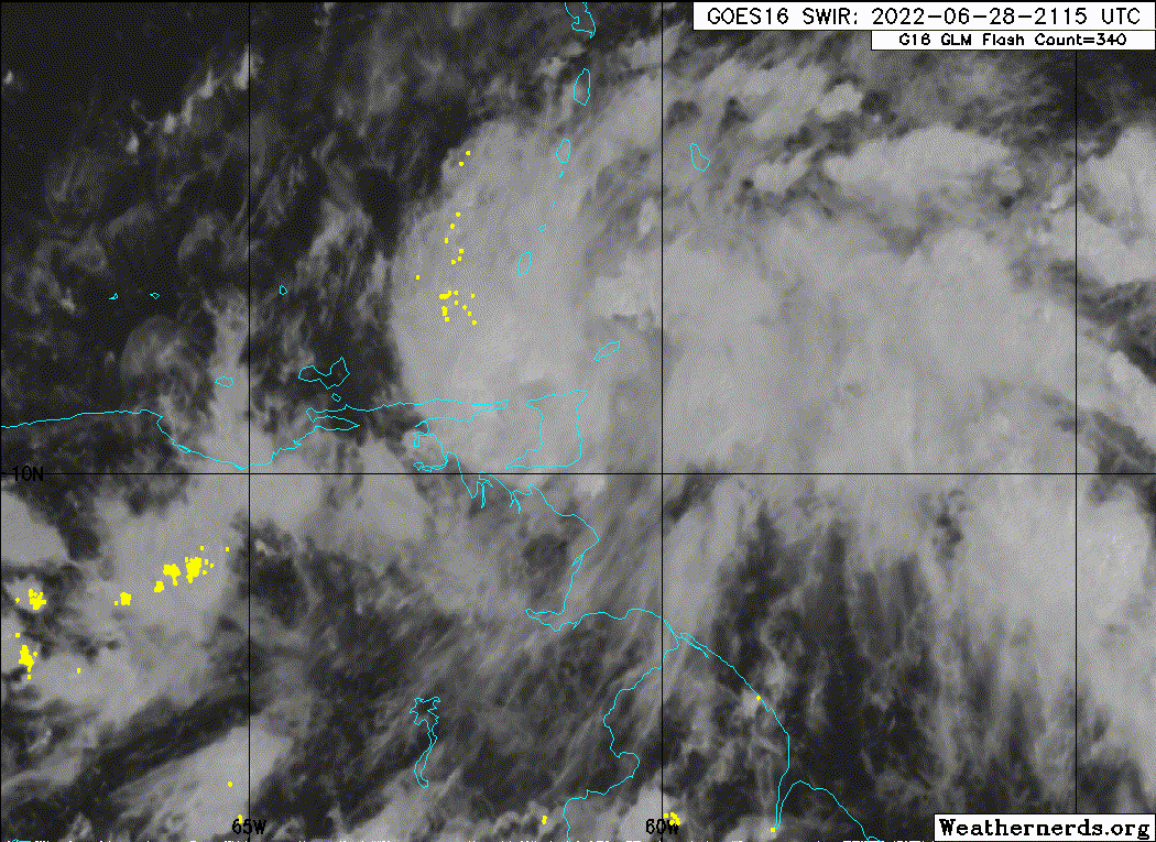
Yeah - south side was very limited in terms of convection and wind compared to further north. Center of the system appeared to have passed either over or just north of Tobago, and a hurricane-force wind gust was recorded on Grenada, along with other TS-force sustained winds and gusts on nearby islands. https://twitter.com/TTWeatherCenter/status/1541869591273607169
The system as a whole is still somewhat disorganized but surface OBS, radar, and cloud motions seem to indicate we have a developing LLC WSW of Grenada. Might be enough to get named by the next recon flight or even sooner, if convection continues firing near it. Definitely further north than where most models have it, which could have big implications for the strength and track of this system down the line.
Time to cloud-watch!
Last edited by NXStumpy_Robothing on Tue Jun 28, 2022 9:26 pm, edited 1 time in total.
1 likes
Undergraduate Meteorology Student, Georgia Institute of Technology
-
Hurricane Mike
- Category 2
- Posts: 562
- Joined: Tue Apr 10, 2018 7:44 am
Re: ATL: TWO - Potential Tropical Cyclone - Discussion
I'm very impressed by the anti-cyclone the wave is building over the top of it.
0 likes
-
ScottNAtlanta

- Category 5
- Posts: 1998
- Joined: Sat May 25, 2013 3:11 pm
- Location: Atlanta, GA
Re: ATL: TWO - Potential Tropical Cyclone - Discussion
I don't know how much this can organize moving at 23kts to the west. There does, however, seem to be a circulation drilling down to the surface west of Grenada.
With these systems the weather is mostly on the north side.
With these systems the weather is mostly on the north side.
0 likes
The posts in this forum are NOT official forecast and should not be used as such. They are just the opinion of the poster and may or may not be backed by sound meteorological data. They are NOT endorsed by any professional institution or storm2k.org. For official information, please refer to the NHC and NWS products.
-
Sciencerocks
- Category 5
- Posts: 7282
- Age: 38
- Joined: Thu Jul 06, 2017 1:51 am
-
Kingarabian

- S2K Supporter

- Posts: 15432
- Joined: Sat Aug 08, 2009 3:06 am
- Location: Honolulu, Hawaii
Re: ATL: TWO - Potential Tropical Cyclone - Discussion
Granted Harvey was about 100 miles off the coast of SA, But we can't forget models were forecasting something like this

Hopefully land interaction limits its chances in gaining a coherent LLC.
Hopefully land interaction limits its chances in gaining a coherent LLC.
1 likes
RIP Kobe Bryant
-
CrazyC83
- Professional-Met

- Posts: 33393
- Joined: Tue Mar 07, 2006 11:57 pm
- Location: Deep South, for the first time!
Re: ATL: TWO - Potential Tropical Cyclone - Discussion
If this was moving slower and it was August, I think this would be a much bigger deal. The 25 mph forward speed does not help a developing system at all.
4 likes
-
Category5Kaiju

- Category 5
- Posts: 3351
- Age: 22
- Joined: Thu Dec 24, 2020 12:45 pm
- Location: Seattle
Re: ATL: TWO - Potential Tropical Cyclone - Discussion
With this system, and Elsa, and countless other June/July systems historically in the Atlantic, what I've just started to realize is how having little dry air, low shear, and very wam ssts in the Caribbean are still not enough for a decent system, especially if this system travels at 20+ mph speeds. I think this linear speed disadvantage is one of the main reasons, if not the main reason, aside from shear, dry air, and sst, why it's so hard to get a major Caribbean system in June and July. This really shows how 2005 was in a divine, hellish realm of its own to have a Cat 4 and a Cat 5 during a time when storms should, at the very most, struggle to really develop into anything major thanks to the sheer speed at which they travel.
4 likes
Unless explicitly stated, all information covered in my posts is based on my opinions and observations. Please refer to a professional meteorologist or an accredited weather research agency otherwise, especially if serious decisions must be made in the event of a potentially life-threatening tropical storm or hurricane.
-
CrazyC83
- Professional-Met
- Posts: 33393
- Joined: Tue Mar 07, 2006 11:57 pm
- Location: Deep South, for the first time!
Re: ATL: TWO - Potential Tropical Cyclone - Discussion
Category5Kaiju wrote:With this system, and Elsa, and countless other June/July systems historically in the Atlantic, what I've just started to realize is how having little dry air, low shear, and very wam ssts in the Caribbean are still not enough for a decent system, especially if this system travels at 20+ mph speeds. I think this linear speed disadvantage is one of the main reasons, if not the main reason, aside from shear, dry air, and sst, why it's so hard to get a major Caribbean system in June and July. This really shows how 2005 was in a divine, hellish realm of its own to have a Cat 4 and a Cat 5 during a time when storms should, at the very most, struggle to really develop into anything major thanks to the sheer speed at which they travel.
There are always the odd exceptions: Charley in 2004 managed to take off despite moving at a quick clip. But that was exceptional. Unlike at higher latitudes, there is no baroclinic forcing or trough divergence in the deep tropics that can offset a fast forward speed.
1 likes
-
cycloneye
- Admin
- Posts: 139025
- Age: 67
- Joined: Thu Oct 10, 2002 10:54 am
- Location: San Juan, Puerto Rico
Re: ATL: TWO - Potential Tropical Cyclone - Discussion
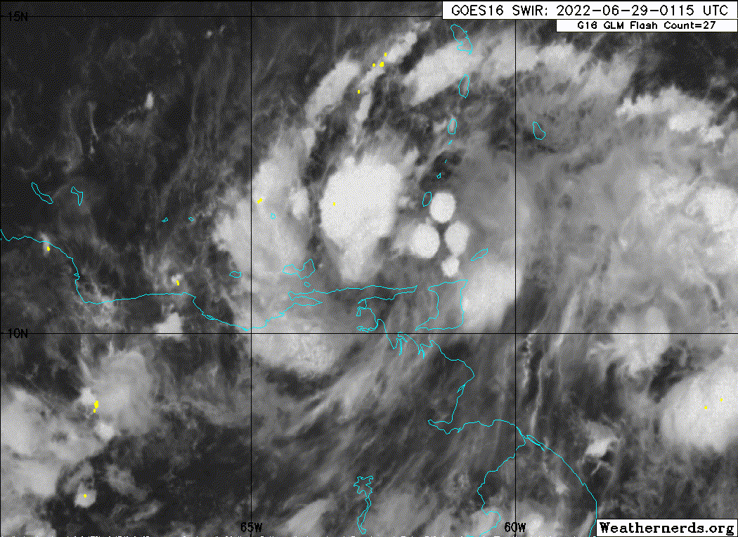
Looks ready to be classified as TS Bonnie but has to have a LLC.

0 likes
Visit the Caribbean-Central America Weather Thread where you can find at first post web cams,radars
and observations from Caribbean basin members Click Here
and observations from Caribbean basin members Click Here
Who is online
Users browsing this forum: No registered users and 28 guests