ATL: IAN - Post-Tropical - Discussion
Moderator: S2k Moderators


Re: ATL: IAN - Hurricane - Discussion
Are we sure this is the same Ian we were tracking yesterday? Good lord.
1 likes


Re: ATL: IAN - Hurricane - Discussion
Sciencerocks wrote:https://imagizer.imageshack.com/img922/2236/tsitYr.gif
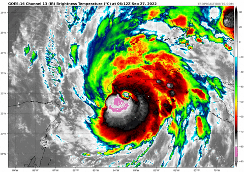
Lightning in the southwest and west eyewall as Ian makes landfall on the south coast of Cuba - usually signs of a strengthening, intense hurricane.
2 likes
Personal Forecast Disclaimer:
The posts in this forum are NOT official forecast and should not be used as such. They are just the opinion of the poster and may or may not be backed by sound meteorological data. They are NOT endorsed by any professional institution or storm2k.org. For official information, please refer to the NHC and NWS products.
The posts in this forum are NOT official forecast and should not be used as such. They are just the opinion of the poster and may or may not be backed by sound meteorological data. They are NOT endorsed by any professional institution or storm2k.org. For official information, please refer to the NHC and NWS products.
Re: ATL: IAN - Hurricane - Discussion
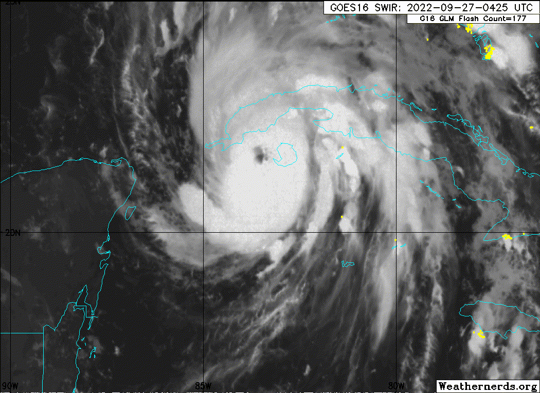
Here's the current radar loop form the Cuban weather radar at La Bajada.
Source - http://www.insmet.cu/asp/genesis.asp?TB ... B1=RADARES
Source - http://www.insmet.cu/asp/genesis.asp?TB ... B1=RADARES
1 likes

Re: ATL: IAN - Hurricane - Discussion
It's almost as if Ian realized it was about to landfall on Cuba and had to live up to his MH before Cuba forecast. Because he's intensifying rapidly right now. Will be interesting to see what sort of effect Cuba has on Ian's core. And I know many people here are focused on Florida, but Cuba is also gonna take a really big hit from Ian. Cities such as Pinar del Río (almost 200,000 people) are directly in Ian's track.
6 likes
Re: ATL: IAN - Hurricane - Discussion
...IAN CONTINUES TO STRENGTHEN AND MAKES LANDFALL OVER WESTERN
CUBA...
Satellite and radar data indicate that the center of Ian has made
landfall just southwest of the town of La Coloma in the Pinar Del
Rio Province of Cuba at 430 AM EDT...0830 UTC. Maximum sustained
winds at landfall were estimated to be 125 MPH (205 KM/H). This
makes Ian a category 3 hurricane on the Saffir-Simpson Hurricane
Wind Scale.
SUMMARY OF 430 AM EDT...0830 UTC...INFORMATION
----------------------------------------------
LOCATION...22.2N 83.7W
ABOUT 15 MI...25 KM S OF THE CITY OF PINAR DEL RIO CUBA
ABOUT 80 MI...130 KM ENE OF THE WESTERN TIP OF CUBA
MAXIMUM SUSTAINED WINDS...125 MPH...205 KM/H
PRESENT MOVEMENT...N OR 350 DEGREES AT 12 MPH...19 KM/H
MINIMUM CENTRAL PRESSURE...952 MB...28.11 INCHES
7 likes
Re: ATL: IAN - Hurricane - Discussion
Wow from 60 kt to 110 kt in 24 hours. In the end Ian more than qualified for rapid intensification and even slightly surpassed the original 105 kt Cuba landfall forecast. Raw T# is up to 6.8 (135 kt, 927 mb).
Last edited by kevin on Tue Sep 27, 2022 3:39 am, edited 1 time in total.
6 likes
-
Jelmergraaff
- Tropical Storm

- Posts: 127
- Age: 21
- Joined: Fri Aug 27, 2021 1:00 pm
- Location: The Netherlands
Re: ATL: IAN - Hurricane - Discussion
Landy wrote:...IAN CONTINUES TO STRENGTHEN AND MAKES LANDFALL OVER WESTERN
CUBA...
Satellite and radar data indicate that the center of Ian has made
landfall just southwest of the town of La Coloma in the Pinar Del
Rio Province of Cuba at 430 AM EDT...0830 UTC. Maximum sustained
winds at landfall were estimated to be 125 MPH (205 KM/H). This
makes Ian a category 3 hurricane on the Saffir-Simpson Hurricane
Wind Scale.
SUMMARY OF 430 AM EDT...0830 UTC...INFORMATION
----------------------------------------------
LOCATION...22.2N 83.7W
ABOUT 15 MI...25 KM S OF THE CITY OF PINAR DEL RIO CUBA
ABOUT 80 MI...130 KM ENE OF THE WESTERN TIP OF CUBA
MAXIMUM SUSTAINED WINDS...125 MPH...205 KM/H
PRESENT MOVEMENT...N OR 350 DEGREES AT 12 MPH...19 KM/H
MINIMUM CENTRAL PRESSURE...952 MB...28.11 INCHES
Second special advisory in two hours???

3 likes
20-year old meteorologist from The Netherlands. Interested in all fields of meteorology, including tropical systems like hurricanes.
Re: ATL: IAN - Hurricane - Discussion
A 115kt gust has been recorded south of Pinar del Rio.
https://twitter.com/cnp_insmet_cuba/status/1574679451626983426
https://twitter.com/cnp_insmet_cuba/status/1574679451626983426
4 likes
-
REDHurricane

- Tropical Storm
- Posts: 206
- Age: 26
- Joined: Sun Jul 03, 2022 2:36 pm
- Location: Northeast Pacific Ocean
Re: ATL: IAN - Hurricane - Discussion
The current intensity also makes Ian the strongest hurricane to make landfall in western Cuba since Gustav in 2008.
5 likes

Re: ATL: IAN - Tropical Storm - Discussion
ConvergenceZone wrote:aspen wrote:Hammy wrote:
If it's struggling than clearly the environment isn't ideal. Storms that have these sorts of internal issues take days and days to recover, and today it's only begun that process.
That’s the thing: the environment was forecast to be ideal — very low shear, >60-70% RH, excellent UL outflow, high OHC and SSTs, etc — but clearly the models have missed something significant that’ll impact Ian’s future track and intensity.
Yea, I'm doubting it will be a major by the time it reaches Cuba, probably somewhere in the Cat 2 area, which is great news as it will probably mean less strength when it enters the gulf. Still thinking 85mph to 100 mph at landfall.......
125 mph
1 likes
Re: ATL: IAN - Hurricane - Discussion
So Ian went from a 75 mph minimal hurricane to 125 mph strong category 3 storm in 24 hours, an increase in 50 mph!
Also from a 45 mph storm at 5pm Sunday to 125 mph this morning at 5am. So that's 80 mph in 36 hours. That's some rapid intensification right there!
Also from a 45 mph storm at 5pm Sunday to 125 mph this morning at 5am. So that's 80 mph in 36 hours. That's some rapid intensification right there!
4 likes
Re: ATL: IAN - Hurricane - Discussion
unfortunately wouldn't be surprised if it got to 150mph in the gulf now
4 likes
-
johngaltfla

- Category 5

- Posts: 1938
- Joined: Sun Jul 10, 2005 9:17 pm
- Location: Sarasota County, FL
- Contact:
Re: ATL: IAN - Hurricane - Discussion
0500 Advisory is out and more warnings have been added with the cone shift/expansion:
WATCHES AND WARNINGS
--------------------
CHANGES WITH THIS ADVISORY:
The Hurricane Warning has been extended southward along the west
coast of Florida to Bonita Beach
A Tropical Storm Warning has been issued for the Middle Florida
Keys from the Channel 5 Bridge westward to the Seven Mile Bridge.
A Tropical Storm Warning has been issued for the west coast of
Florida from the Anclote River northward to the Suwannee River.
A Tropical Storm Warning has been issued along the east coast of
Florida from Jupiter Inlet to the Volusia/Brevard County Line
including Lake Okeechobee.
A Tropical Storm Watch has been issued for southeast coast of
Florida from Deerfield Beach northward to Jupiter Inlet.
1 likes
-
johngaltfla
- Category 5
- Posts: 1938
- Joined: Sun Jul 10, 2005 9:17 pm
- Location: Sarasota County, FL
- Contact:
Re: ATL: IAN - Hurricane - Discussion
Graphics version; note no weakening it comes on shore as a major near Tampa:

5 likes
Re: ATL: IAN - Hurricane - Discussion
Ryxn wrote:So Ian went from a 75 mph minimal hurricane to 125 mph strong category 3 storm in 24 hours, an increase in 50 mph!
Also from a 45 mph storm at 5pm Sunday to 125 mph this morning at 5am. So that's 80 mph in 36 hours. That's some rapid intensification right there!
I think Ian should serve as a reminder about future downcasting of storms or thinking they are going to run out of time before they get to point "x".
This thing just detonated, and after a couple of days of milling about it locked in and got better every single hour.
5 likes

-
johngaltfla
- Category 5
- Posts: 1938
- Joined: Sun Jul 10, 2005 9:17 pm
- Location: Sarasota County, FL
- Contact:

-
johngaltfla
- Category 5
- Posts: 1938
- Joined: Sun Jul 10, 2005 9:17 pm
- Location: Sarasota County, FL
- Contact:
Re: ATL: IAN - Hurricane - Discussion
cjrciadt wrote:Final T# Adj T# Raw T#
5.8 5.9 7.2
We're gonna get whacked hard. Ugh.
4 likes
Re: ATL: IAN - Hurricane - Discussion
Hey I just woke up and we were on page 120, what did I miss
5 likes
Who is online
Users browsing this forum: No registered users and 49 guests