what is your prediction for the intensity at landfall on the FL west coast? It appears the guidance is steadily dropping. Is it possible it is only a TS by the time the shear in the gulf is done with it?wxman57 wrote:Hurricane Mike wrote:I think the further east this goes, the stronger. If it mills in the Gulf too long interacting with the trough, it'll weaken more prior to landfall. It's also possible further east movement with the trough could allow it to strengthen similar to Charley or Wilma on their approach to Florida.
I think the opposite. The farther east it goes, it's because it's encountering strong westerly winds aloft (shear). In addition, it would cut across some tall mountains in Cuba. Might peak east of Florida in that case.
ATL: IAN - Post-Tropical - Discussion
Moderator: S2k Moderators
-
otowntiger
- Category 5

- Posts: 1787
- Joined: Tue Aug 31, 2004 7:06 pm
- Location: Orlando
Re: ATL: INVEST 98L - Discussion
1 likes


-
skyline385

- Category 5
- Posts: 2444
- Age: 33
- Joined: Wed Aug 26, 2020 11:15 pm
- Location: Palm Beach County FL
Re: ATL: INVEST 98L - Discussion
TD?
AL, 98, 2022092300, , BEST, 0, 129N, 672W, 30, 1006, LO, 34, NEQ, 0, 0, 0, 0, 1010, 150, 70, 0, 0, L, 0, , 0, 0, INVEST, S, 0, , 0, 0, 0, 0, genesis-num, 028,
0 likes
-
eastcoastFL

- Category 5
- Posts: 3437
- Age: 42
- Joined: Thu Apr 12, 2007 12:29 pm
- Location: Palm City, FL
Re: ATL: INVEST 98L - Discussion
Looks like it’s putting the dry air and sheer behind it
1 likes
Personal Forecast Disclaimer:
The posts in this forum are NOT official forecast and should not be used as such. They are just the opinion of the poster and may or may not be backed by sound meteorological data. They are NOT endorsed by any professional institution or storm2k.org. For official information, please refer to the NHC and NWS products.
The posts in this forum are NOT official forecast and should not be used as such. They are just the opinion of the poster and may or may not be backed by sound meteorological data. They are NOT endorsed by any professional institution or storm2k.org. For official information, please refer to the NHC and NWS products.
-
Aric Dunn
- Category 5
- Posts: 21228
- Age: 41
- Joined: Sun Sep 19, 2004 9:58 pm
- Location: Ready for the Chase.
- Contact:
Re: ATL: INVEST 98L - Discussion
ScottNAtlanta wrote:SFLcane wrote:Aric Dunn wrote:Should be TD ..
Engines ready!
https://i.postimg.cc/c1BQ33Hf/8-F4-E0364-2794-4-A8-F-B069-2-B76-B10-A8-FBD.gif
I am starting to think the GFS developing the south end of the wave is right as opposed to the Euro trying to spin up the top. It looks like the spin is already started on the south end
You definitely shouldn't buy into the eastern solutions. Euro very likely over doing the weakness left behind from Fiona then add in the right bias (typically from exaggerating troughs). You should find the middle ground here. Also definitely wait until models have more data.
Also... I guess that one transitory shower over a weak swirl wasn't meaningless...
Last edited by Aric Dunn on Thu Sep 22, 2022 7:59 pm, edited 1 time in total.
4 likes
Note: If I make a post that is brief. Please refer back to previous posts for the analysis or reasoning. I do not re-write/qoute what my initial post said each time.
If there is nothing before... then just ask
Space & Atmospheric Physicist, Embry-Riddle Aeronautical University,
I believe the sky is falling...
If there is nothing before... then just ask
Space & Atmospheric Physicist, Embry-Riddle Aeronautical University,
I believe the sky is falling...
-
Iceresistance

- Category 5
- Posts: 8910
- Age: 20
- Joined: Sat Oct 10, 2020 9:45 am
- Location: Tecumseh, OK/Norman, OK
Re: ATL: INVEST 98L - Discussion
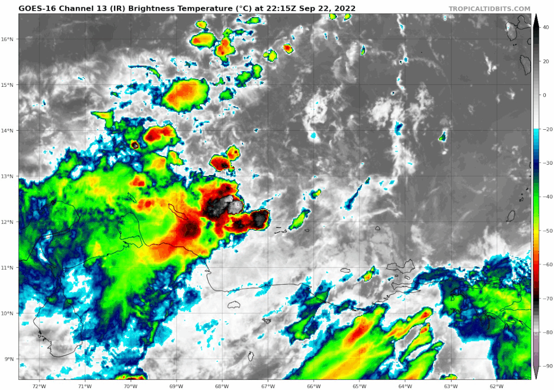
The convection is intense! It does not take much to get this going.
1 likes
Bill 2015 & Beta 2020
Winter 2020-2021
All observations are in Tecumseh, OK unless otherwise noted.
Winter posts are focused mainly for Oklahoma & Texas.
Take any of my forecasts with a grain of salt, refer to the NWS, SPC, and NHC for official information
Never say Never with weather! Because ANYTHING is possible!
Winter 2020-2021
All observations are in Tecumseh, OK unless otherwise noted.
Winter posts are focused mainly for Oklahoma & Texas.
Take any of my forecasts with a grain of salt, refer to the NWS, SPC, and NHC for official information
Never say Never with weather! Because ANYTHING is possible!
-
eastcoastFL
- Category 5
- Posts: 3437
- Age: 42
- Joined: Thu Apr 12, 2007 12:29 pm
- Location: Palm City, FL
Re: ATL: INVEST 98L - Discussion
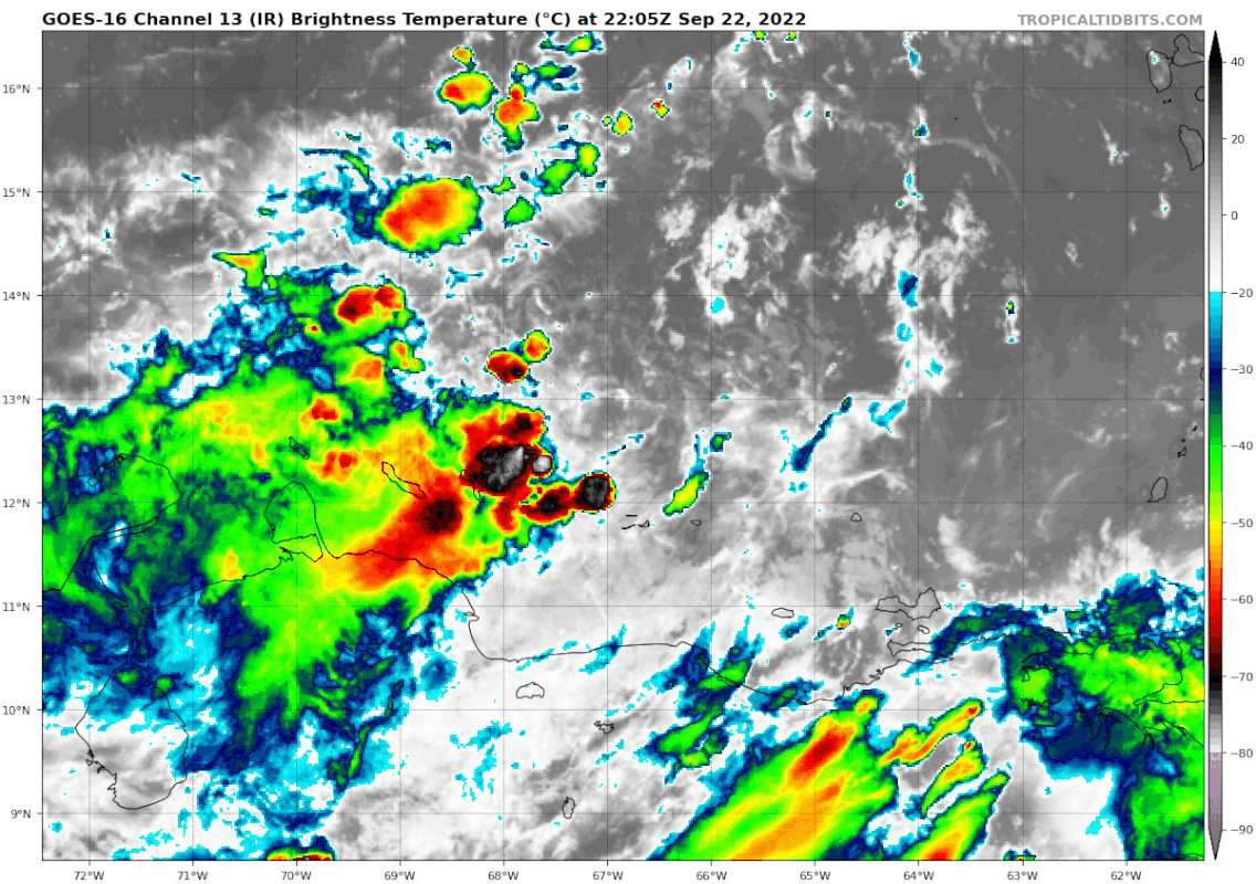
Caribbean wide view

7 likes
Personal Forecast Disclaimer:
The posts in this forum are NOT official forecast and should not be used as such. They are just the opinion of the poster and may or may not be backed by sound meteorological data. They are NOT endorsed by any professional institution or storm2k.org. For official information, please refer to the NHC and NWS products.
The posts in this forum are NOT official forecast and should not be used as such. They are just the opinion of the poster and may or may not be backed by sound meteorological data. They are NOT endorsed by any professional institution or storm2k.org. For official information, please refer to the NHC and NWS products.

Re: ATL: INVEST 98L - Discussion
skyline385 wrote:TD?AL, 98, 2022092300, , BEST, 0, 129N, 672W, 30, 1006, LO, 34, NEQ, 0, 0, 0, 0, 1010, 150, 70, 0, 0, L, 0, , 0, 0, INVEST, S, 0, , 0, 0, 0, 0, genesis-num, 028,
Doesn't LO mean a low instead of a TC?
0 likes
-
skyline385
- Category 5
- Posts: 2444
- Age: 33
- Joined: Wed Aug 26, 2020 11:15 pm
- Location: Palm Beach County FL
Re: ATL: INVEST 98L - Discussion
Teban54 wrote:skyline385 wrote:TD?AL, 98, 2022092300, , BEST, 0, 129N, 672W, 30, 1006, LO, 34, NEQ, 0, 0, 0, 0, 1010, 150, 70, 0, 0, L, 0, , 0, 0, INVEST, S, 0, , 0, 0, 0, 0, genesis-num, 028,
Doesn't LO mean a low instead of a TC?
yea i accidently glanced over the invest part as well. No change it looks like...
0 likes
-
eastcoastFL
- Category 5
- Posts: 3437
- Age: 42
- Joined: Thu Apr 12, 2007 12:29 pm
- Location: Palm City, FL
Re: ATL: INVEST 98L - Discussion
SST’s looking pretty ripe along the predicted path

0 likes
Personal Forecast Disclaimer:
The posts in this forum are NOT official forecast and should not be used as such. They are just the opinion of the poster and may or may not be backed by sound meteorological data. They are NOT endorsed by any professional institution or storm2k.org. For official information, please refer to the NHC and NWS products.
The posts in this forum are NOT official forecast and should not be used as such. They are just the opinion of the poster and may or may not be backed by sound meteorological data. They are NOT endorsed by any professional institution or storm2k.org. For official information, please refer to the NHC and NWS products.
-
skyline385
- Category 5
- Posts: 2444
- Age: 33
- Joined: Wed Aug 26, 2020 11:15 pm
- Location: Palm Beach County FL
Re: ATL: INVEST 98L - Discussion
WTNT21 KNGU 222100
SUBJ/TROPICAL CYCLONE FORMATION ALERT (98L) REISSUED//
REF/A/FLTWEACEN NORFOLK VA/212100Z SEP 22//
AMPN/REF IS TROPICAL CYCLONE FORMATION ALERT(WTNT21 KNGU 212100)//
RMKS/1.FORMATION OF A SIGNIFICANT TROPICAL CYCLONE IS POSSIBLE
WITHIN 100 NM EITHER SIDE OF A LINE FROM 12.2N 66.2W TO 14.0N 70.9W
WITHIN THE NEXT 24 HOURS. AVAILABLE DATA DOES NOT JUSTIFY
ISSUANCE OF NUMBERED TROPICAL CYCLONE WARNINGS AT THIS TIME.
WINDS IN THE AREA ARE ESTIMATED TO BE 25 TO 30 KNOTS. METSAT
IMAGERY AT 221800Z INDICATES THAT A CIRCULATION CENTER IS LOCATED
NEAR 12.3N 66.3W. THE SYSTEM IS MOVING WEST-NORTHWESTWARD AT 12
KNOTS.
2.REMARKS:AN AREA OF LOW PRESSURE HAS FORMED IN THE SOUTHEASTERN
CARIBBEAN SEA. SHOWERS AND THUNDERSTORMS ARE BECOMING BETTER
ORGANIZED AND SURFACE PRESSURES ARE BEGINNING TO FALL. ENVIRONMENTAL
CONDITIONS ARE CONDUCIVE FOR FURTHER DEVELOPMENT AND A TROPICAL
DEPRESSION COULD FORM DURING THE NEXT 24 HOURS AS IT MOVES WEST-
NORTHWESTWARD OVER THE ISLANDS THIS EVENING AND INTO THE CENTRAL
CARIBBEAN SEA THROUGH THE WEEKEND.
3.THIS MESSAGE SUPERSEDES REF A. THIS ALERT WILL BE REISSUED,
SUPERSEDED BY POTENTIAL TROPICAL CYCLONE ADVISORY, UPGRADED TO
WARNING, OR CANCELLED BY 232100Z.//

3 likes
-
ConvergenceZone
.gif)
- Category 5
- Posts: 4833
- Joined: Fri Jul 29, 2005 1:40 am
- Location: Northern California
Re: ATL: INVEST 98L - Discussion
eastcoastFL wrote:SST’s looking pretty ripe along the predicted path
https://www.ssd.noaa.gov/PS/TROP/DATA/RT/SST/ATL/20.jpg
Of course what helps the STDs is the fact that it's untapped due to such low tropical activity in the carib this season...
1 likes
-
typhoonty
- Tropical Depression

- Posts: 94
- Age: 29
- Joined: Wed May 31, 2017 10:37 pm
- Location: Fort Myers / Tallahassee, FL
- Contact:
Re: ATL: INVEST 98L - Discussion
When forecasting formative tropical cyclones facing moderate to heavy shear vectors, I have been well served in expecting a center reformation or two to occur downshear as the vortex tries to align itself with the deepest convection. You can sort of see this happening on the 18Z HWRF, multiple center reformations southwest as 98L gets vertically stacked. This will make it difficult, though not impossible, to squeeze east of the Florida Peninsula.
1 likes
FSU Meteorology student, opinions are mine, 18 years experience covering TC's, consult NHC/Local officials when making decisions.
Gabrielle '01, Michelle '01, Charley '04, Frances '04, Dennis '05, Katrina '05, Rita '05, Wilma '05, Fay '08, Isaac '12 Hermine '16, Irma '17, Gordon '18, Michael '18, Eta '20 IAN '22
Gabrielle '01, Michelle '01, Charley '04, Frances '04, Dennis '05, Katrina '05, Rita '05, Wilma '05, Fay '08, Isaac '12 Hermine '16, Irma '17, Gordon '18, Michael '18, Eta '20 IAN '22
-
cycloneye

- Admin

- Posts: 139025
- Age: 67
- Joined: Thu Oct 10, 2002 10:54 am
- Location: San Juan, Puerto Rico
Re: ATL: INVEST 98L - Discussion
00z Best Track:
AL, 98, 2022092300, , BEST, 0, 129N, 672W, 30, 1006, LO
0 likes
Visit the Caribbean-Central America Weather Thread where you can find at first post web cams,radars
and observations from Caribbean basin members Click Here
and observations from Caribbean basin members Click Here
-
Iceresistance
- Category 5
- Posts: 8910
- Age: 20
- Joined: Sat Oct 10, 2020 9:45 am
- Location: Tecumseh, OK/Norman, OK
Re: ATL: INVEST 98L - Discussion
ConvergenceZone wrote:eastcoastFL wrote:SST’s looking pretty ripe along the predicted path
https://www.ssd.noaa.gov/PS/TROP/DATA/RT/SST/ATL/20.jpg
Of course what helps the STDs is the fact that it's untapped due to such low tropical activity in the carib this season...
The OHC is also crazy high too, we could have an absolute beast with this one.
1 likes
Bill 2015 & Beta 2020
Winter 2020-2021
All observations are in Tecumseh, OK unless otherwise noted.
Winter posts are focused mainly for Oklahoma & Texas.
Take any of my forecasts with a grain of salt, refer to the NWS, SPC, and NHC for official information
Never say Never with weather! Because ANYTHING is possible!
Winter 2020-2021
All observations are in Tecumseh, OK unless otherwise noted.
Winter posts are focused mainly for Oklahoma & Texas.
Take any of my forecasts with a grain of salt, refer to the NWS, SPC, and NHC for official information
Never say Never with weather! Because ANYTHING is possible!

Re: ATL: INVEST 98L - Discussion
eastcoastFL wrote:SST’s looking pretty ripe along the predicted path
https://www.ssd.noaa.gov/PS/TROP/DATA/RT/SST/ATL/20.jpg
Again, I don't understand why I'm seeing replicated pages on this board from days ago.
I open a new page and it is the same posts with later post numbers from pages ago. Is there
something wrong with my Google browser or is something goofy going on with this web site?
0 likes
-
eastcoastFL
- Category 5
- Posts: 3437
- Age: 42
- Joined: Thu Apr 12, 2007 12:29 pm
- Location: Palm City, FL
Re: ATL: INVEST 98L - Discussion
ConvergenceZone wrote:eastcoastFL wrote:SST’s looking pretty ripe along the predicted path
https://www.ssd.noaa.gov/PS/TROP/DATA/RT/SST/ATL/20.jpg
Of course what helps the STDs is the fact that it's untapped due to such low tropical activity in the carib this season...
.
I hadn’t considered that. Pretty fresh pools for now.
0 likes
Personal Forecast Disclaimer:
The posts in this forum are NOT official forecast and should not be used as such. They are just the opinion of the poster and may or may not be backed by sound meteorological data. They are NOT endorsed by any professional institution or storm2k.org. For official information, please refer to the NHC and NWS products.
The posts in this forum are NOT official forecast and should not be used as such. They are just the opinion of the poster and may or may not be backed by sound meteorological data. They are NOT endorsed by any professional institution or storm2k.org. For official information, please refer to the NHC and NWS products.
-
eastcoastFL
- Category 5
- Posts: 3437
- Age: 42
- Joined: Thu Apr 12, 2007 12:29 pm
- Location: Palm City, FL
Re: ATL: INVEST 98L - Discussion
hipshot wrote:eastcoastFL wrote:SST’s looking pretty ripe along the predicted path
https://www.ssd.noaa.gov/PS/TROP/DATA/RT/SST/ATL/20.jpg
Again, I don't understand why I'm seeing replicated pages on this board from days ago.
I open a new page and it is the same posts with later post numbers from pages ago. Is there
something wrong with my Google browser or is something goofy going on with this web site?
I just posted that 10 mins ago.
0 likes
Personal Forecast Disclaimer:
The posts in this forum are NOT official forecast and should not be used as such. They are just the opinion of the poster and may or may not be backed by sound meteorological data. They are NOT endorsed by any professional institution or storm2k.org. For official information, please refer to the NHC and NWS products.
The posts in this forum are NOT official forecast and should not be used as such. They are just the opinion of the poster and may or may not be backed by sound meteorological data. They are NOT endorsed by any professional institution or storm2k.org. For official information, please refer to the NHC and NWS products.
-
Iceresistance
- Category 5
- Posts: 8910
- Age: 20
- Joined: Sat Oct 10, 2020 9:45 am
- Location: Tecumseh, OK/Norman, OK
Re: ATL: INVEST 98L - Discussion
hipshot wrote:eastcoastFL wrote:SST’s looking pretty ripe along the predicted path
https://www.ssd.noaa.gov/PS/TROP/DATA/RT/SST/ATL/20.jpg
Again, I don't understand why I'm seeing replicated pages on this board from days ago.
I open a new page and it is the same posts with later post numbers from pages ago. Is there
something wrong with my Google browser or is something goofy going on with this web site?
Mods/admins cleaning up this forum due to useless posts.
0 likes
Bill 2015 & Beta 2020
Winter 2020-2021
All observations are in Tecumseh, OK unless otherwise noted.
Winter posts are focused mainly for Oklahoma & Texas.
Take any of my forecasts with a grain of salt, refer to the NWS, SPC, and NHC for official information
Never say Never with weather! Because ANYTHING is possible!
Winter 2020-2021
All observations are in Tecumseh, OK unless otherwise noted.
Winter posts are focused mainly for Oklahoma & Texas.
Take any of my forecasts with a grain of salt, refer to the NWS, SPC, and NHC for official information
Never say Never with weather! Because ANYTHING is possible!
-
eastcoastFL
- Category 5
- Posts: 3437
- Age: 42
- Joined: Thu Apr 12, 2007 12:29 pm
- Location: Palm City, FL
Re: ATL: INVEST 98L - Discussion
Aric Dunn wrote:ScottNAtlanta wrote:SFLcane wrote:
Engines ready!
https://i.postimg.cc/c1BQ33Hf/8-F4-E0364-2794-4-A8-F-B069-2-B76-B10-A8-FBD.gif
I am starting to think the GFS developing the south end of the wave is right as opposed to the Euro trying to spin up the top. It looks like the spin is already started on the south end
You definitely shouldn't buy into the eastern solutions. Euro very likely over doing the weakness left behind from Fiona then add in the right bias (typically from exaggerating troughs). You should find the middle ground here. Also definitely wait until models have more data.
Also... I guess that one transitory shower over a weak swirl wasn't meaningless...
The run right now is showing a very strong trough. Does that seem overblown? I don’t remember seeing it before. I wonder how much these shift once they classify it. It seems it should be a TD by morning now unless convection dies off.
1 likes
Personal Forecast Disclaimer:
The posts in this forum are NOT official forecast and should not be used as such. They are just the opinion of the poster and may or may not be backed by sound meteorological data. They are NOT endorsed by any professional institution or storm2k.org. For official information, please refer to the NHC and NWS products.
The posts in this forum are NOT official forecast and should not be used as such. They are just the opinion of the poster and may or may not be backed by sound meteorological data. They are NOT endorsed by any professional institution or storm2k.org. For official information, please refer to the NHC and NWS products.
Who is online
Users browsing this forum: No registered users and 23 guests