ATL: IAN - Post-Tropical - Discussion
Moderator: S2k Moderators
-
tropicwatch

- Category 5

- Posts: 3205
- Age: 60
- Joined: Sat Jun 02, 2007 10:01 am
- Location: Panama City Florida
- Contact:
Re: ATL: IAN - Tropical Storm - Discussion
I think they missed the center. The winds and pressure are too high for where they marked the wind shift.
7 likes
Tropicwatch
Agnes 72', Eloise 75, Elena 85', Kate 85', Charley 86', Florence 88', Beryl 94', Dean 95', Erin 95', Opal 95', Earl 98', Georges 98', Ivan 2004', Arlene 2005', Dennis 2005', Ida 2009' Debby 2012' Irma 2017' Michael 2018'
Agnes 72', Eloise 75, Elena 85', Kate 85', Charley 86', Florence 88', Beryl 94', Dean 95', Erin 95', Opal 95', Earl 98', Georges 98', Ivan 2004', Arlene 2005', Dennis 2005', Ida 2009' Debby 2012' Irma 2017' Michael 2018'

Re: ATL: IAN - Tropical Storm - Discussion
sunnyday wrote:I keep hearing that Florida is in for flooding rain. The SE coast of Fl isn’t even in the cone. Maybe that fact should be mentioned.
being in or out of the cone has nothing to do with storm impact...
5 likes
Just like Jon Snow..."I know nothing" except what I know, and most of what I know is gathered by the fine people of the NHC
Re: ATL: IAN - Tropical Storm - Discussion
tropicwatch wrote:I think they missed the center. The winds and pressure are too high for where they marked the wind shift.
I was thinking something like this
1 likes

Re: ATL: IAN - Tropical Storm - Discussion
Convection warming and eyewall rain looks weaker over the last few frames so still dealing with dry air.
1 likes
The above post is not official and should not be used as such. It is the opinion of the poster and may or may not be backed by sound meteorological data. It is not endorsed by any professional institution or storm2k.org. For official information, please refer to the NHC and NWS products.
-
skillz305
- Tropical Storm

- Posts: 197
- Joined: Sat Sep 08, 2018 11:10 am
- Location: Miami, Florida --> Vero Beach, Florida
Re: ATL: IAN - Tropical Storm - Discussion
Not much of a cone shift at 8pm! 11pm will be INTERESTING!
2 likes
 Hurricanes: Andrew 1992 - Irene 1999 - Frances 2004 - Jeanne 2004 - Katrina 2005 - Wilma 2005 - Matthew 2016 - Irma 2017 - Ian 2022 - Nicole 2022
Re: ATL: IAN - Tropical Storm - Discussion
tropicwatch wrote:I think they missed the center. The winds and pressure are too high for where they marked the wind shift.
Wind barbs are perpendicular as he flew into the western eyewall square.
Looks like a tight circulation still moving roughly WNW.
0 likes
Re: ATL: IAN - Tropical Storm - Discussion
skillz305 wrote:Not much of a cone shift at 8pm! 11pm will be INTERESTING!
Just a note, they don't update the cone at 8 and 2pm advisories, just at 5 and 11. That said it's pretty far north so the track graphic looks odd since they only update the initial position.
8 likes
-
MarioProtVI
- Category 2

- Posts: 670
- Age: 22
- Joined: Sun Sep 29, 2019 7:33 pm
- Location: New Jersey
Re: ATL: IAN - Tropical Storm - Discussion
Apparently NOAA3 aircraft have a low FL bias in “weak” storms like Ian so they tend to lean more towards SFMR, and given the surface improvements Ian has done today and the fact the first pass had a 55 kt SFMR, they went with the data more likely to represent the intensity.
1 likes
-
hohnywx
- Category 2
- Posts: 504
- Age: 33
- Joined: Sun Jul 19, 2009 8:34 pm
- Location: Hastings-on-Hudson, NY
Re: ATL: IAN - Tropical Storm - Discussion
skillz305 wrote:Not much of a cone shift at 8pm! 11pm will be INTERESTING!
There is no change in the forecast track at 8 or 2 AM/PM. Only at 5 and 11 AM/PM
3 likes

Re: ATL: IAN - Tropical Storm - Discussion
CronkPSU wrote:
being in or out of the cone has nothing to do with storm impact...
This is more if an off season discussion, but perhaps the NHC should consider adding wind speed colors outside the cone as the lay person will often think they are safe when they are outside the cone within 72 hours.
3 likes
Re: ATL: IAN - Tropical Storm - Discussion
skillz305 wrote:Not much of a cone shift at 8pm! 11pm will be INTERESTING!
They don't move the cone on intermediate advisories.
3 likes
Re: ATL: IAN - Tropical Storm - Discussion
sunnyday wrote:I keep hearing that Florida is in for flooding rain. The SE coast of Fl isn’t even in the cone. Maybe that fact should be mentioned.
The entire peninsula is broad brushed with 5-10" in the latest WPC estimate. They have been showing heavy rain for days. If you're in Florida east of the track you are getting hosed...even if you're too far east for sustained ts winds.
7 likes
-
cheezyWXguy

- Category 5
- Posts: 5528
- Joined: Mon Feb 13, 2006 12:29 am
- Location: Dallas, TX
Re: ATL: IAN - Tropical Storm - Discussion
wx98 wrote:tropicwatch wrote:I think they missed the center. The winds and pressure are too high for where they marked the wind shift.
I was thinking something like this
Same, it looks to me like they were just a little south of the center. Hard to believe a miss by that small would account for a 7mb difference between passes though. We’ll see what future passes show.
1 likes
-
otowntiger
- Category 5
- Posts: 1787
- Joined: Tue Aug 31, 2004 7:06 pm
- Location: Orlando
Re: ATL: IAN - Tropical Storm - Discussion
Hammy wrote:Convection warming and eyewall rain looks weaker over the last few frames so still dealing with dry air.
I don’t think it’ll be a hurricane by morning.
0 likes
-
Hurricaneman

- Category 5
- Posts: 7281
- Age: 43
- Joined: Tue Aug 31, 2004 3:24 pm
- Location: central florida
Re: ATL: IAN - Tropical Storm - Discussion
otowntiger wrote:Hammy wrote:Convection warming and eyewall rain looks weaker over the last few frames so still dealing with dry air.
I don’t think it’ll be a hurricane by morning.
There’s a major convective burst over the center, might be premature
8 likes
-
MarioProtVI
- Category 2
- Posts: 670
- Age: 22
- Joined: Sun Sep 29, 2019 7:33 pm
- Location: New Jersey
Re: ATL: IAN - Tropical Storm - Discussion
Hammy wrote:Convection warming and eyewall rain looks weaker over the last few frames so still dealing with dry air.
As soon as you said this another -80C pixel showed up at the N end of the burst
1 likes
-
Blown Away

- S2K Supporter

- Posts: 9861
- Joined: Wed May 26, 2004 6:17 am
Re: ATL: IAN - Tropical Storm - Discussion
wx98 wrote:skillz305 wrote:Not much of a cone shift at 8pm! 11pm will be INTERESTING!
They don't move the cone on intermediate advisories.
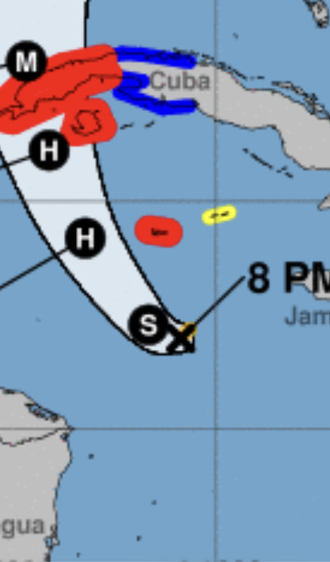
See that tail to the right at the track beginning, that likely means Ian has moved east of the track and an east adjustment coming at next advisory.
0 likes
Hurricane Eye Experience: David 79, Irene 99, Frances 04, Jeanne 04, Wilma 05...
Hurricane Brush Experience: Andrew 92, Erin 95, Floyd 99, Matthew 16, Irma 17, Ian 22, Nicole 22…
Hurricane Brush Experience: Andrew 92, Erin 95, Floyd 99, Matthew 16, Irma 17, Ian 22, Nicole 22…
Re: ATL: IAN - Tropical Storm - Discussion
Blown Away wrote:wx98 wrote:skillz305 wrote:Not much of a cone shift at 8pm! 11pm will be INTERESTING!
They don't move the cone on intermediate advisories.
[url]https://i.postimg.cc/jdYK1vn4/10912550-357-E-4-F6-A-B6-DA-33-CA2-F80-A8-C6.jpg [/url]
See that tail to the right at the track beginning, that likely means Ian has moved east of the track and an east adjustment coming at next advisory.
Yes, and? That doesn't change the fact that they don't move the cone on intermediate advisories.
2 likes
-
StPeteMike

- Category 1

- Posts: 356
- Joined: Thu Jun 07, 2018 11:26 pm
Re: ATL: IAN - Tropical Storm - Discussion
The storm is going to pulse for the next few hours before taking off. Don’t take a change as evidence the storm is weakening by any chance.
7 likes
The above post is not official and should not be used as such. It is the opinion of the poster and may or may not be backed by sound meteorological data. It is not endorsed by any professional institution or storm2k.org. For official information, please refer to the NHC and NWS products.

Re: ATL: IAN - Tropical Storm - Discussion
otowntiger wrote:Hammy wrote:Convection warming and eyewall rain looks weaker over the last few frames so still dealing with dry air.
I don’t think it’ll be a hurricane by morning.
First it was “weren’t not getting a hurricane”, then it was “we’re seeing RI”, now we’re back to “no hurricane”. We’re flip-flopping more than the models have been.
12 likes
Irene '11 Sandy '12 Hermine '16 5/15/2018 Derecho Fay '20 Isaias '20 Elsa '21 Henri '21 Ida '21
I am only a meteorology enthusiast who knows a decent amount about tropical cyclones. Look to the professional mets, the NHC, or your local weather office for the best information.
I am only a meteorology enthusiast who knows a decent amount about tropical cyclones. Look to the professional mets, the NHC, or your local weather office for the best information.
Who is online
Users browsing this forum: No registered users and 47 guests