ATL: IAN - Post-Tropical - Discussion

Moderator: S2k Moderators

Message
Author
User avatar
Kazmit
Category 5
Category 5
Posts: 1915
Age: 21
Joined: Mon Jul 25, 2016 8:49 am
Location: Williamsburg VA for college, Bermuda otherwise

Re: ATL: IAN - Hurricane - Discussion

#2161 Postby Kazmit » Mon Sep 26, 2022 10:00 am

kevin wrote:74 kt FL winds and 69 kt SFMR. Might be enough for an upgrade to 70 kt for the next advisory even though I would also understand keeping it at 65 kt.

Best track puts it at 70kts already.
5 likes   
Igor 2010, Sandy 2012, Fay 2014, Gonzalo 2014, Joaquin 2015, Nicole 2016, Humberto 2019

I am only a tropical weather enthusiast. My predictions are not official and may or may not be backed by sound meteorological data. For official information, please refer to the NHC and NWS products.

User avatar
Iceresistance
Category 5
Category 5
Posts: 8912
Age: 20
Joined: Sat Oct 10, 2020 9:45 am
Location: Tecumseh, OK/Norman, OK

Re: ATL: IAN - Hurricane - Discussion

#2162 Postby Iceresistance » Mon Sep 26, 2022 10:01 am

...IAN FORECAST TO CONTINUE RAPIDLY STRENGTHENING... ...CONDITIONS IN WESTERN CUBA TO DETERIORATE THIS EVENING AND TONIGHT WITH SIGNIFICANT WIND AND STORM SURGE IMPACTS EXPECTED...

11:00 AM EDT Mon Sep 26
Location: 19.1°N 82.7°W
Moving: NW at 13 mph
Min pressure: 980 mb
Max sustained: 80 mph
1 likes   
Bill 2015 & Beta 2020

Winter 2020-2021 :cold:

All observations are in Tecumseh, OK unless otherwise noted.

Winter posts are focused mainly for Oklahoma & Texas.

Take any of my forecasts with a grain of salt, refer to the NWS, SPC, and NHC for official information

Never say Never with weather! Because ANYTHING is possible!

User avatar
kevin
Category 5
Category 5
Posts: 1768
Age: 25
Joined: Wed Aug 28, 2019 4:35 am

Re: ATL: IAN - Hurricane - Discussion

#2163 Postby kevin » Mon Sep 26, 2022 10:01 am

11am discussion:

000
WTNT44 KNHC 261457
TCDAT4

Hurricane Ian Discussion Number 14
NWS National Hurricane Center Miami FL AL092022
1100 AM EDT Mon Sep 26 2022

The satellite presentation of Ian has improved this morning. Deep
convection has increased within the inner core during the past
several hours, with an expanding central dense overcast noted in
recent satellite imagery. The inner core structure continues to take
shape in radar data, although the eyewall still has a banded
appearance and remains open on the west side. Dropsonde data from
the NOAA and Air Force Hurricane Hunter aircraft indicate that the
minimum pressure has gradually fallen to about 980 mb, and the
initial intensity is raised slightly to 70 kt for this advisory.

The intensity of Ian has increased by 30 kt during the past 18 h.
Further rapid intensification (RI) is expected during the next 24-36
h as Ian crosses the high oceanic heat content of the northwestern
Caribbean Sea within a very low vertical wind shear (VWS)
environment. The latest SHIPS-RI probabilities continue to highlight
the high likelihood of this scenario, with a 73 percent chance of a
35-kt wind speed increase in 24 h and a 79 percent chance of a 45-kt
increase in 36 h. The NHC intensity forecast is similar to the
previous one, and it shows Ian becoming a major hurricane by the
time it reaches western Cuba. Ian is forecast to reach its peak
intensity in 36 h over the southeastern Gulf of Mexico. Then,
increasing southwesterly shear by 36-48 h is expected to bring an
end to the intensification phase. The combination of strong VWS and
drier mid-level air will induce weakening thereafter, but Ian is
expected to remain at or near major hurricane strength as it passes
near the west-central coast of Florida on Wednesday and Thursday.

Ian continues to move northwestward at 325/11 kt. A turn toward the
north-northwest and north is expected during the next day or so as
the hurricane moves around the western extent of a mid-level ridge.
Then, an upper-level trough over the eastern U.S. should cause Ian
to turn more north-northeastward through Thursday. This track brings
the center of Ian close to the west-central coast of Florida during
the middle of the week. An even greater concern is the slower
forward motion that is forecast during this period, as the upper
trough passes north and east of Ian and the steering currents
weaken. This would likely prolong the storm surge, wind, and
rainfall impacts along the affected portions of the west coast of
Florida, although the roughly shore-parallel track still makes it
difficult to pinpoint exactly what locations will experience the
most severe impacts. The track guidance has come into better
agreement during the first 72 h of the forecast period, and only a
minor eastward adjustment was made to the NHC track forecast in line
with the multi-model consensus aids.

The aircraft data indicate that the 34-kt wind radii in the
northeastern quadrant were 20-30 n mi larger than previously
estimated, and this has been reflected in the latest forecast.
Based on these changes, Tropical Storm Watches have been issued for
the middle Florida Keys and extended southward along the
southwestern coast of Florida.


Key Messages:

1. Life-threatening storm surge, hurricane-force winds, flash
floods and possible mudslides are expected in portions of western
Cuba beginning this evening and continuing into Tuesday.
Devastating wind damage is possible where the core of Ian moves
across western Cuba. Efforts to protect life and property should be
rushed to completion.

2. Life-threatening storm surge is possible along much of the
Florida west coast, with the highest risk from Fort Myers to the
Tampa Bay region. Residents in these areas should listen to advice
given by local officials.

3. Hurricane-force winds are possible in the hurricane watch area
in west-central Florida beginning Wednesday morning with tropical
storm conditions possible by late Tuesday. Residents in this area
should ensure that they have their hurricane plan in place.

4. Heavy rainfall will increase across the Florida Keys and south
Florida Tuesday, spreading to central and northern Florida Wednesday
and Thursday, potentially causing flash, urban and small stream
flooding. Significant prolonged river flooding is likely across
central Florida.


FORECAST POSITIONS AND MAX WINDS

INIT 26/1500Z 19.1N 82.7W 70 KT 80 MPH
12H 27/0000Z 20.7N 83.5W 90 KT 105 MPH
24H 27/1200Z 22.7N 84.0W 105 KT 120 MPH
36H 28/0000Z 24.5N 84.0W 120 KT 140 MPH
48H 28/1200Z 26.1N 83.8W 120 KT 140 MPH
60H 29/0000Z 27.2N 83.5W 105 KT 120 MPH
72H 29/1200Z 28.0N 83.2W 90 KT 105 MPH
96H 30/1200Z 29.8N 82.9W 55 KT 65 MPH...INLAND
120H 01/1200Z 32.8N 82.6W 30 KT 35 MPH...INLAND

$$
Forecaster Reinhart
4 likes   

User avatar
beachnut
S2K Supporter
S2K Supporter
Posts: 39
Joined: Wed Aug 31, 2016 6:44 pm
Location: Cape Coral. FL

Re: ATL: IAN - Hurricane - Discussion

#2164 Postby beachnut » Mon Sep 26, 2022 10:02 am

karenfromheaven wrote:
Sanibel wrote:RI probably gulped-in some remnant dry air from Fiona...


This is a tough call on evacuation here on Sanibel because of the Charley factor...Plus I think this one might have surge unlike Charley, Wilma, and Irma...


The Bermuda High will make us or break us...

Have you studied the CERA website for surge? The bridge causeway off the island is underwater. You'll be cut off given the current NHC 13 track. That's without any Charlie-type deviations.


Karen, do you prefer the CERA map or the NHC inudation map? South Cape below CC Pkwy shows nothing except for a few small areas, yet the NHC map shows yellow (>3') for almost everywhere south of Veterans. I understand this can and will change but I'm trying to understand the discrepancy.
1 likes   
Elena '85 - Charley '04 - Wilma '05 - Irma '17 - Ian '22 - Idalia '23

User avatar
Iceresistance
Category 5
Category 5
Posts: 8912
Age: 20
Joined: Sat Oct 10, 2020 9:45 am
Location: Tecumseh, OK/Norman, OK

Re: ATL: IAN - Hurricane - Discussion

#2165 Postby Iceresistance » Mon Sep 26, 2022 10:05 am

Recon also shows 981 mb as the lowest extrapolated pressure at the eye.
1 likes   
Bill 2015 & Beta 2020

Winter 2020-2021 :cold:

All observations are in Tecumseh, OK unless otherwise noted.

Winter posts are focused mainly for Oklahoma & Texas.

Take any of my forecasts with a grain of salt, refer to the NWS, SPC, and NHC for official information

Never say Never with weather! Because ANYTHING is possible!

User avatar
wxman57
Moderator-Pro Met
Moderator-Pro Met
Posts: 22480
Age: 66
Joined: Sat Jun 21, 2003 8:06 pm
Location: Houston, TX (southwest)

Re: ATL: IAN - Hurricane - Discussion

#2166 Postby wxman57 » Mon Sep 26, 2022 10:05 am

NHC track is in line with 12Z TVCN, and very close to my track. I do have lots of doubt about the track beyond Tuesday. It bugs me that some models have shifted the track farther offshore Wed/Thu. On the bright side, it would mean less severe impacts to the western Peninsula. It would also mean a weaker hurricane at landfall if it tracks any west of the current forecast, possibly only a TS at landfall. Would likely be hard hit by shear and dry air intrusion. We won't really be confident in where it will eventually go for another day or so.
6 likes   

CryHavoc
Tropical Storm
Tropical Storm
Posts: 201
Age: 41
Joined: Thu Aug 24, 2017 5:18 pm
Location: Bay Area CA

Re: ATL: IAN - Hurricane - Discussion

#2167 Postby CryHavoc » Mon Sep 26, 2022 10:07 am

Iceresistance wrote:
ElectricStorm wrote:SE eyewall stronger than last pass, also down to 981 and not at the center yet


The crazy pressure gradient is the part that bothers me the most.

https://s4.gifyu.com/images/recon_AF300-1409A-IAN_zoom.png


You see sharp gradients often with developing TCs, especially in areas where there is ample fuel. At times the pressure drops but it takes a while for the winds to match. I believe it was Ike from 2008 that showed repeated pressure drops with a very slow wind speed increase.
2 likes   

CryHavoc
Tropical Storm
Tropical Storm
Posts: 201
Age: 41
Joined: Thu Aug 24, 2017 5:18 pm
Location: Bay Area CA

Re: ATL: IAN - Hurricane - Discussion

#2168 Postby CryHavoc » Mon Sep 26, 2022 10:09 am

Ugh, the evacuation page for the greater Tampa Area is down.

Not great timing to have a server outage.
4 likes   

KC7NEC
Tropical Storm
Tropical Storm
Posts: 145
Joined: Wed Oct 05, 2016 12:01 am

Re: ATL: IAN - Hurricane - Discussion

#2169 Postby KC7NEC » Mon Sep 26, 2022 10:11 am

CryHavoc wrote:Ugh, the evacuation page for the greater Tampa Area is down.

Not great timing to have a server outage.


A page that gets maybe 10 hits a day suddenly getting hundreds a minute will do that.
5 likes   
// Opinions are my own, I am not a Meteorologist. Consult the NHC or Local NWS and Emergency Management for current information in your area. //

User avatar
chris_fit
Category 5
Category 5
Posts: 3078
Joined: Wed Sep 10, 2003 11:58 pm
Location: Tampa Bay Area, FL
Contact:

Re: ATL: IAN - Hurricane - Discussion

#2170 Postby chris_fit » Mon Sep 26, 2022 10:11 am

wxman57 wrote:NHC track is in line with 12Z TVCN, and very close to my track. I do have lots of doubt about the track beyond Tuesday. It bugs me that some models have shifted the track farther offshore Wed/Thu. On the bright side, it would mean less severe impacts to the western Peninsula. It would also mean a weaker hurricane at landfall if it tracks any west of the current forecast, possibly only a TS at landfall. Would likely be hard hit by shear and dry air intrusion. We won't really be confident in where it will eventually go for another day or so.


How's that jet thing looking that's supposed to push Ian more the E - You had talked about this int he days past. Anything new on that front?
2 likes   

User avatar
robbielyn
Category 5
Category 5
Posts: 1239
Joined: Wed May 07, 2003 9:45 am
Location: brooksville, fl

Re: ATL: IAN - Hurricane - Discussion

#2171 Postby robbielyn » Mon Sep 26, 2022 10:19 am

chris_fit wrote:
wxman57 wrote:NHC track is in line with 12Z TVCN, and very close to my track. I do have lots of doubt about the track beyond Tuesday. It bugs me that some models have shifted the track farther offshore Wed/Thu. On the bright side, it would mean less severe impacts to the western Peninsula. It would also mean a weaker hurricane at landfall if it tracks any west of the current forecast, possibly only a TS at landfall. Would likely be hard hit by shear and dry air intrusion. We won't really be confident in where it will eventually go for another day or so.


How's that jet thing looking that's supposed to push Ian more the E - You had talked about this int he days past. Anything new on that front?

craig seltzer just had a live streaming video on that and it will pull it ne. i found the it interesting that the disco didn’t say uncertainty of the track is evident in days 3-5 this time. seems like they are hovering the hurricane over the tampabay region just offshore with big bend ts landfall.
1 likes   
Robbielyn McCrary
I know just about enough to sound like I know what I'm talking about sometimes. But for your safety please follow the nhc for truly professional forecasting. :D

User avatar
AdamFirst
S2K Supporter
S2K Supporter
Posts: 2487
Age: 35
Joined: Thu Aug 14, 2008 10:54 am
Location: Port Saint Lucie, FL

Re: ATL: IAN - Hurricane - Discussion

#2172 Postby AdamFirst » Mon Sep 26, 2022 10:20 am

The core of Ian is now showing up on archaic Cuban radar.

Thanks to the Cayman Islands and Cuba, we have full radar coverage for this storm up until Florida landfall.

http://www.insmet.cu/asp/genesis.asp?TB ... AXw01a.gif
2 likes   
Dolphins Marlins Canes Golden Panthers HEAT
Andrew 1992 - Irene 1999 - Frances 2004 - Jeanne 2004 - Wilma 2005 - Fay 2008 - Isaac 2012 - Matthew 2016 - Irma 2017 - Dorian 2019 - Ian 2022 - Nicole 2022

CryHavoc
Tropical Storm
Tropical Storm
Posts: 201
Age: 41
Joined: Thu Aug 24, 2017 5:18 pm
Location: Bay Area CA

Re: ATL: IAN - Hurricane - Discussion

#2173 Postby CryHavoc » Mon Sep 26, 2022 10:22 am

KC7NEC wrote:
CryHavoc wrote:Ugh, the evacuation page for the greater Tampa Area is down.

Not great timing to have a server outage.


A page that gets maybe 10 hits a day suddenly getting hundreds a minute will do that.


Sure but it's an emergency situation, they can anticipate the vastly increased server load and add bandwidth ahead of time.

There's a 0% chance they didn't know that the page was going to get swamped. People need the info, it's a really bad look when they can't get it. At the very least they should have a backup txt only page to send out basic info.
5 likes   

Aric Dunn
Category 5
Category 5
Posts: 21228
Age: 41
Joined: Sun Sep 19, 2004 9:58 pm
Location: Ready for the Chase.
Contact:

Re: ATL: IAN - Hurricane - Discussion

#2174 Postby Aric Dunn » Mon Sep 26, 2022 10:23 am

And there are the Sw and southern eyewall towers been waiting for... the eye will poke out soon...
6 likes   
Note: If I make a post that is brief. Please refer back to previous posts for the analysis or reasoning. I do not re-write/qoute what my initial post said each time.
If there is nothing before... then just ask :)

Space & Atmospheric Physicist, Embry-Riddle Aeronautical University,
I believe the sky is falling...

User avatar
Weatherboy1
Category 5
Category 5
Posts: 1167
Age: 48
Joined: Mon Jul 05, 2004 1:50 pm
Location: Jupiter, FL

Re: ATL: IAN - Hurricane - Discussion

#2175 Postby Weatherboy1 » Mon Sep 26, 2022 10:28 am

It sure seems based on satellite imagery that Ian is going to hit Isla de la Juventud directly, rather than miss it to the west and landfall in western Cuba. That would put it, what? 30 miles or so east of forecast points if so? Just wondering because that could have implications for eventual landfall in Florida
4 likes   

User avatar
kevin
Category 5
Category 5
Posts: 1768
Age: 25
Joined: Wed Aug 28, 2019 4:35 am

Re: ATL: IAN - Hurricane - Discussion

#2176 Postby kevin » Mon Sep 26, 2022 10:29 am

Latest VIS:

Image
8 likes   

CryHavoc
Tropical Storm
Tropical Storm
Posts: 201
Age: 41
Joined: Thu Aug 24, 2017 5:18 pm
Location: Bay Area CA

Re: ATL: IAN - Hurricane - Discussion

#2177 Postby CryHavoc » Mon Sep 26, 2022 10:30 am

Image

Sorry to say that this appears to be a worst case scenario unfolding here if this track holds. Most alarming hurricane forecast I've seen in many years. Shades of Harvey here.

In this forecast Tampa would get torrential rain for 48 continuous hours. There is no way to reliably estimate how much damage that would cause other than catastrophic - and that's nearly independent of how strong Ian is when he comes ashore.
7 likes   

User avatar
ElectricStorm
Category 5
Category 5
Posts: 4532
Age: 23
Joined: Tue Aug 13, 2019 11:23 pm
Location: Skiatook, OK / Norman, OK

Re: ATL: IAN - Hurricane - Discussion

#2178 Postby ElectricStorm » Mon Sep 26, 2022 10:32 am

NW quad has improved as well, with hurricane force FL winds now, looks like the overall wind field has improved dramatically since last night
2 likes   
I am in no way a professional. Take what I say with a grain of salt as I could be totally wrong. Please refer to the NHC, NWS, or SPC for official information.

Boomer Sooner!

User avatar
pgoss11
Category 2
Category 2
Posts: 702
Joined: Tue Sep 02, 2003 3:55 pm

Re: ATL: IAN - Hurricane - Discussion

#2179 Postby pgoss11 » Mon Sep 26, 2022 10:36 am

Weatherboy1 wrote:It sure seems based on satellite imagery that Ian is going to hit Isla de la Juventud directly, rather than miss it to the west and landfall in western Cuba. That would put it, what? 30 miles or so east of forecast points if so? Just wondering because that could have implications for eventual landfall in Florida

Looks possible but wouldn’t Ian have to go on a straight north heading for that to happen?
1 likes   

User avatar
eastcoastFL
Category 5
Category 5
Posts: 3437
Age: 42
Joined: Thu Apr 12, 2007 12:29 pm
Location: Palm City, FL

Re: ATL: IAN - Hurricane - Discussion

#2180 Postby eastcoastFL » Mon Sep 26, 2022 10:39 am

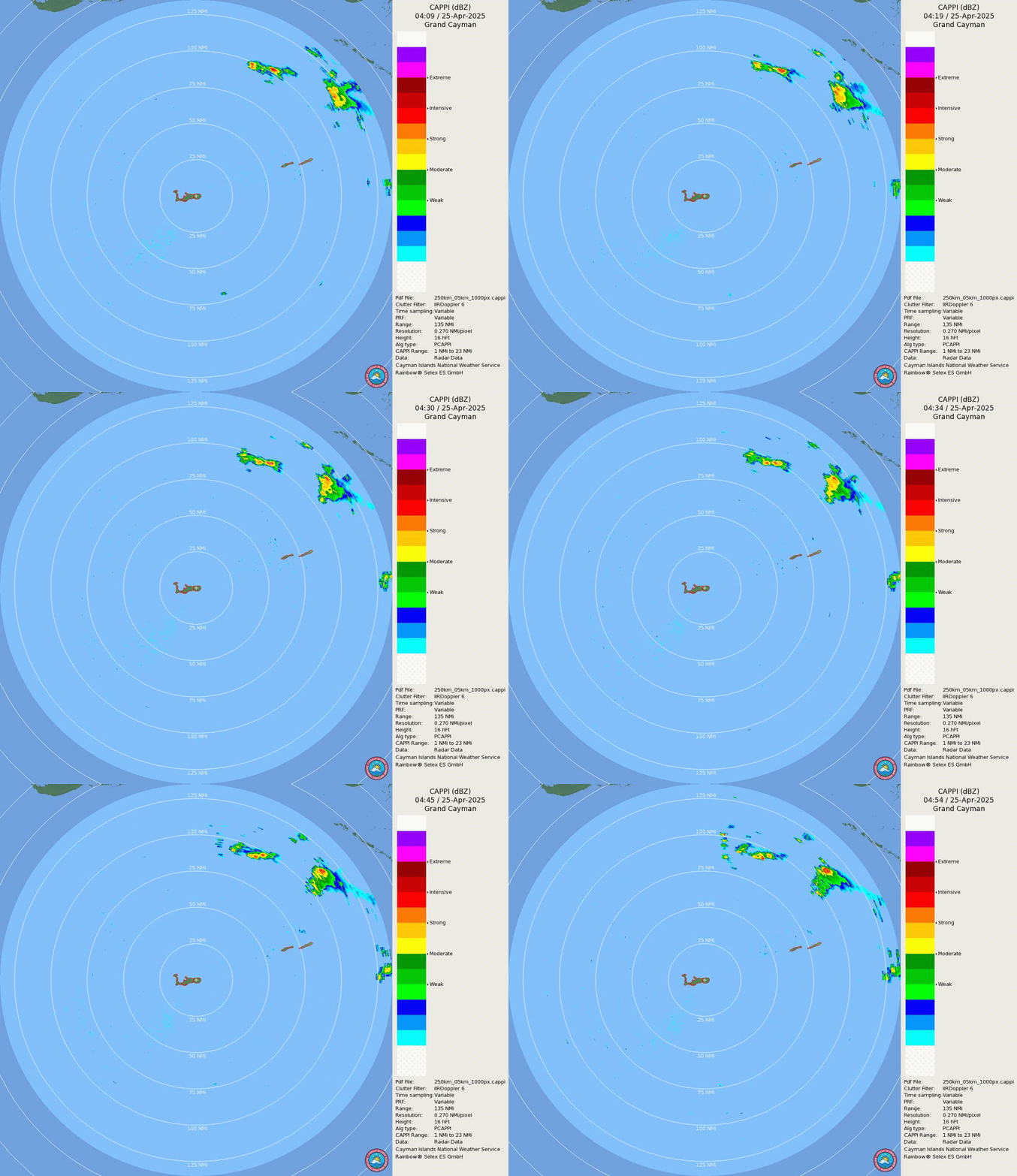
Looking better and better on radar this morning out of the Caymans

Image
6 likes   
Personal Forecast Disclaimer:
The posts in this forum are NOT official forecast and should not be used as such. They are just the opinion of the poster and may or may not be backed by sound meteorological data. They are NOT endorsed by any professional institution or storm2k.org. For official information, please refer to the NHC and NWS products.


Return to “2022”

Who is online

Users browsing this forum: No registered users and 60 guests