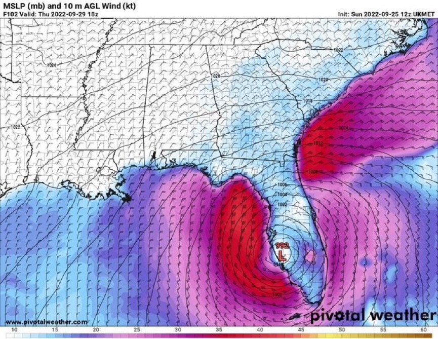
ATL: IAN - Models

Moderator: S2k Moderators

Message
Author
Michele B
Category 4
Category 4
Posts: 906
Joined: Thu Aug 25, 2016 8:08 am
Location: SWFL

Re: ATL: IAN - Models

#2441 Postby Michele B » Sun Sep 25, 2022 3:53 pm

2 likes   
Cleo - 1964, Betsy - 1965, David - 1979, Andrew - 1992, Charlie (Francis, Ivan, Jeanne) - 2004, Irma - 2017, Ian - 2022

User avatar
ColdMiser123
Professional-Met
Professional-Met
Posts: 778
Age: 27
Joined: Mon Sep 26, 2016 3:26 pm
Location: Northeast US

Re: ATL: IAN - Models

#2442 Postby ColdMiser123 » Sun Sep 25, 2022 3:57 pm

Another NE shift on the 18z ICON compared to 12z, the 21z forecast (5 pm EDT) looked basically spot on to where Ian is currently located.
2 likes   
B.S., M.S., Meteorology & Atmospheric Science

User avatar
HurricaneBelle
S2K Supporter
S2K Supporter
Posts: 974
Joined: Sun Aug 27, 2006 6:12 pm
Location: Clearwater, FL

Re: ATL: IAN - Models

#2443 Postby HurricaneBelle » Sun Sep 25, 2022 3:57 pm

While I'd love to see Ian weak and stay weak, I'd rather have say, a Cat 2 coming down from a Cat 3 than a Cat 1 increasing to a Cat 3 as it makes landfall as weakening storms tend to have trouble mixing down their winds as opposed to strengthening storms which pack more of a punch. To put it in terms of Louisiana hurricanes, I'd rather get hit by a Lili than an Ida.
4 likes   

Frank P
S2K Supporter
S2K Supporter
Posts: 2408
Joined: Fri Aug 29, 2003 10:52 am
Location: Biloxi Beach, Ms

Re: ATL: IAN - Models

#2444 Postby Frank P » Sun Sep 25, 2022 3:59 pm

Frank P wrote:
jlauderdal wrote:
Frank P wrote:Actually the 18z NAM looks creditable with Ian heading towards NE/NNE towards the west coast of Fl, run ends att.

https://i.ibb.co/BcRGShY/2-C2-D4-D41-5-F08-48-D3-B408-12606-E51574-F.jpg

You are a brave man posting the NAM in a tropical setup. It has value, but there are plenty of NAM haters.

Yeah, well if the model fits, I post it… haha, there’s several models I hate but I still post them… heck it might even beat the GFS!
6 likes   

AutoPenalti
Category 5
Category 5
Posts: 3949
Age: 27
Joined: Mon Aug 17, 2015 4:16 pm
Location: Ft. Lauderdale, Florida

Re: ATL: IAN - Models

#2445 Postby AutoPenalti » Sun Sep 25, 2022 4:01 pm

I thought it was proven NAM can’t be used for tropical disturbances.
1 likes   
The posts in this forum are NOT official forecasts and should not be used as such. They are just the opinion of the poster and may or may not be backed by sound meteorological data. They are NOT endorsed by any professional institution or STORM2K. For official information, please refer to products from the NHC and NWS.


Model Runs Cheat Sheet:
GFS (5:30 AM/PM, 11:30 AM/PM)
HWRF, GFDL, UKMET, NAVGEM (6:30-8:00 AM/PM, 12:30-2:00 AM/PM)
ECMWF (1:45 AM/PM)

TCVN
is a weighted averaged

Frank P
S2K Supporter
S2K Supporter
Posts: 2408
Joined: Fri Aug 29, 2003 10:52 am
Location: Biloxi Beach, Ms

Re: ATL: IAN - Models

#2446 Postby Frank P » Sun Sep 25, 2022 4:06 pm

AutoPenalti wrote:I thought it was proven NAM can’t be used for tropical disturbances.

Hmmmm, well this is a model forum, and it is a model, and it forecast a hurricane, and I just used it… so there’s that! Ha! 8-)
8 likes   

User avatar
DESTRUCTION5
Category 5
Category 5
Posts: 4391
Age: 42
Joined: Wed Sep 03, 2003 11:25 am
Location: Stuart, FL

Re: ATL: IAN - Models

#2447 Postby DESTRUCTION5 » Sun Sep 25, 2022 4:06 pm

18z Icon E shift with strike south of Sarasota.
1 likes   
GATOR NATION IS E V E R Y W H E R E !

User avatar
Bocadude85
Category 5
Category 5
Posts: 2941
Age: 37
Joined: Mon Apr 18, 2005 2:20 pm
Location: Honolulu,Hi

Re: ATL: IAN - Models

#2448 Postby Bocadude85 » Sun Sep 25, 2022 4:06 pm

18Z ICON with another eastward shift, looks to come ashore around Punta Gorda
2 likes   

User avatar
skyline385
Category 5
Category 5
Posts: 2444
Age: 33
Joined: Wed Aug 26, 2020 11:15 pm
Location: Palm Beach County FL

Re: ATL: IAN - Models

#2449 Postby skyline385 » Sun Sep 25, 2022 4:11 pm

18Z ICON east shift

Image
2 likes   

BobHarlem
Category 5
Category 5
Posts: 1665
Joined: Thu Oct 20, 2005 6:11 pm

Re: ATL: IAN - Models

#2450 Postby BobHarlem » Sun Sep 25, 2022 4:21 pm

18z Icon right shift from Bradenton to Venice/Englewood, then rides up I-4 to Daytona.
Image
Last edited by BobHarlem on Sun Sep 25, 2022 4:25 pm, edited 1 time in total.
1 likes   

User avatar
NDG
S2K Supporter
S2K Supporter
Posts: 14933
Joined: Sun Jul 09, 2006 10:14 pm
Location: Orlando, FL

Re: ATL: IAN - Models

#2451 Postby NDG » Sun Sep 25, 2022 4:23 pm

18z Icon shifts to the east, South of Venice then NE to Kissimmee and to Titusville.
0 likes   

skillz305
Tropical Storm
Tropical Storm
Posts: 197
Joined: Sat Sep 08, 2018 11:10 am
Location: Miami, Florida --> Vero Beach, Florida

Re: ATL: IAN - Models

#2452 Postby skillz305 » Sun Sep 25, 2022 4:23 pm

18z ICON takes Ian thru Florida then rides up the east coast of the US for a bit.
1 likes   
:flag:Hurricanes: Andrew 1992 - Irene 1999 - Frances 2004 - Jeanne 2004 - Katrina 2005 - Wilma 2005 - Matthew 2016 - Irma 2017 - Ian 2022 - Nicole 2022

User avatar
StPeteMike
Category 1
Category 1
Posts: 355
Joined: Thu Jun 07, 2018 11:26 pm

Re: ATL: IAN - Models

#2453 Postby StPeteMike » Sun Sep 25, 2022 4:28 pm

ICON is overdoing it. I can’t see that sudden of a turn to the NE to allow it that south.
0 likes   
The above post is not official and should not be used as such. It is the opinion of the poster and may or may not be backed by sound meteorological data. It is not endorsed by any professional institution or storm2k.org. For official information, please refer to the NHC and NWS products.

User avatar
cjrciadt
S2K Supporter
S2K Supporter
Posts: 1615
Joined: Mon Aug 22, 2005 1:11 pm
Location: Kissimmee, FL

Re: ATL: IAN - Models

#2454 Postby cjrciadt » Sun Sep 25, 2022 4:28 pm

NDG wrote:18z Icon shifts to the east, South of Venice then NE to [b]Kissimmee/b] and to Titusville.

Ugh, but makes sense to jog NE thru the weakness.
2 likes   

User avatar
Blown Away
S2K Supporter
S2K Supporter
Posts: 9861
Joined: Wed May 26, 2004 6:17 am

Re: ATL: IAN - Models

#2455 Postby Blown Away » Sun Sep 25, 2022 4:30 pm

NDG wrote:18z Icon shifts to the east, South of Venice then NE to Kissimmee and to Titusville.

Image

As these models continue shifting SE we should see most drop the stall and start showing smooth NE recurve into the Atlantic. ICON is very close, I suspect 00z will show nice transition into the Atlantic.
1 likes   
Hurricane Eye Experience: David 79, Irene 99, Frances 04, Jeanne 04, Wilma 05...
Hurricane Brush Experience: Andrew 92, Erin 95, Floyd 99, Matthew 16, Irma 17, Ian 22, Nicole 22…

tolakram
Admin
Admin
Posts: 19165
Age: 60
Joined: Sun Aug 27, 2006 8:23 pm
Location: Florence, KY (name is Mark)

Re: ATL: IAN - Models

#2456 Postby tolakram » Sun Sep 25, 2022 4:40 pm

GFS 18Z INIT
Image
1 likes   
M a r k
- - - - -
Join us in chat: Storm2K Chatroom Invite. Android and IOS apps also available.

The posts in this forum are NOT official forecasts and should not be used as such. Posts are NOT endorsed by any professional institution or STORM2K.org. For official information and forecasts, please refer to NHC and NWS products.

tolakram
Admin
Admin
Posts: 19165
Age: 60
Joined: Sun Aug 27, 2006 8:23 pm
Location: Florence, KY (name is Mark)

Re: ATL: IAN - Models

#2457 Postby tolakram » Sun Sep 25, 2022 4:41 pm

Image
2 likes   
M a r k
- - - - -
Join us in chat: Storm2K Chatroom Invite. Android and IOS apps also available.

The posts in this forum are NOT official forecasts and should not be used as such. Posts are NOT endorsed by any professional institution or STORM2K.org. For official information and forecasts, please refer to NHC and NWS products.

tolakram
Admin
Admin
Posts: 19165
Age: 60
Joined: Sun Aug 27, 2006 8:23 pm
Location: Florence, KY (name is Mark)

Re: ATL: IAN - Models

#2458 Postby tolakram » Sun Sep 25, 2022 4:43 pm

Image
1 likes   
M a r k
- - - - -
Join us in chat: Storm2K Chatroom Invite. Android and IOS apps also available.

The posts in this forum are NOT official forecasts and should not be used as such. Posts are NOT endorsed by any professional institution or STORM2K.org. For official information and forecasts, please refer to NHC and NWS products.

tolakram
Admin
Admin
Posts: 19165
Age: 60
Joined: Sun Aug 27, 2006 8:23 pm
Location: Florence, KY (name is Mark)

Re: ATL: IAN - Models

#2459 Postby tolakram » Sun Sep 25, 2022 4:46 pm

Image
1 likes   
M a r k
- - - - -
Join us in chat: Storm2K Chatroom Invite. Android and IOS apps also available.

The posts in this forum are NOT official forecasts and should not be used as such. Posts are NOT endorsed by any professional institution or STORM2K.org. For official information and forecasts, please refer to NHC and NWS products.

skillz305
Tropical Storm
Tropical Storm
Posts: 197
Joined: Sat Sep 08, 2018 11:10 am
Location: Miami, Florida --> Vero Beach, Florida

Re: ATL: IAN - Models

#2460 Postby skillz305 » Sun Sep 25, 2022 4:47 pm

18z GFS at hour 30 is NE of previous runs
1 likes   
:flag:Hurricanes: Andrew 1992 - Irene 1999 - Frances 2004 - Jeanne 2004 - Katrina 2005 - Wilma 2005 - Matthew 2016 - Irma 2017 - Ian 2022 - Nicole 2022


Return to “2022”

Who is online

Users browsing this forum: No registered users and 24 guests