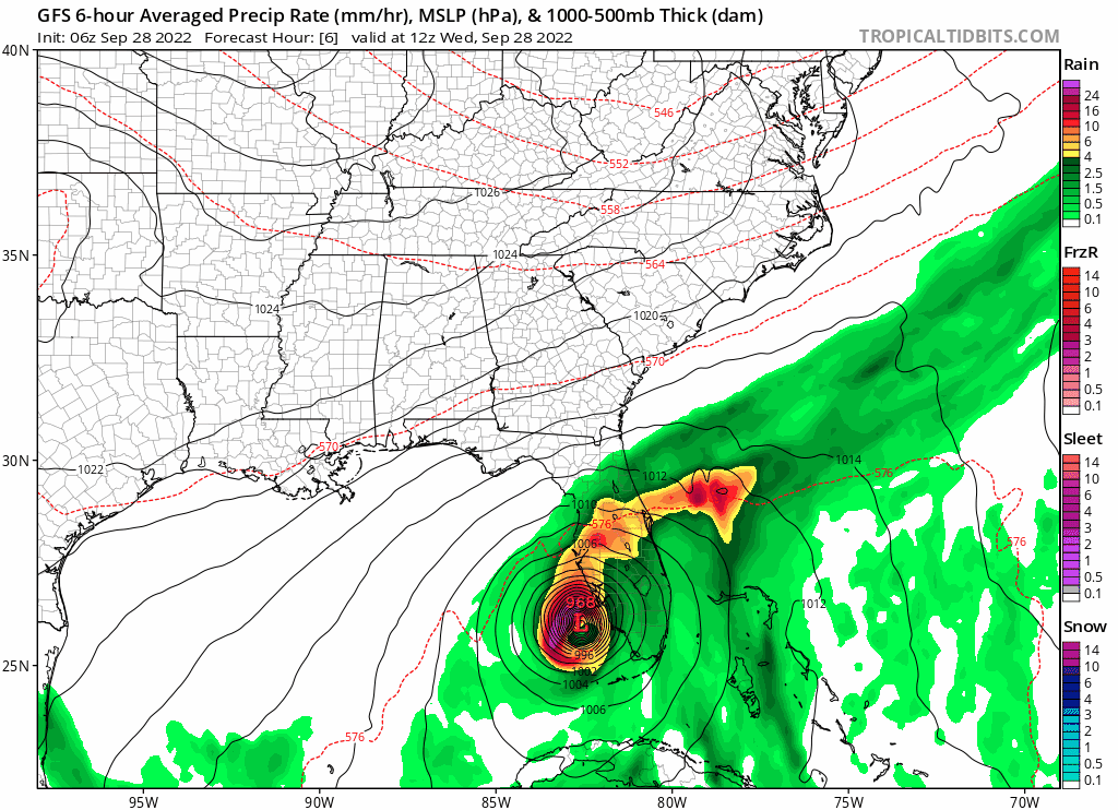
06 GFS… Notice it shows a little E jog after landfall, I think the GFS landfall point was a bit N of Ian now, but it appears Ian is moving slowly @ENE?
Moderator: S2k Moderators


Blown Away wrote:[url]https://i.postimg.cc/sxpnqP9D/gfs-mslp-pcpn-frzn-seus-fh6-36.gif [/url]
06 GFS… Notice it shows a little E jog after landfall, I think the GFS landfall point was a bit N of Ian now, but it appears Ian is moving slowly @ENE?

Blown Away wrote:[url]https://i.postimg.cc/sxpnqP9D/gfs-mslp-pcpn-frzn-seus-fh6-36.gif [/url]
06 GFS… Notice it shows a little E jog after landfall, I think the GFS landfall point was a bit N of Ian now, but it appears Ian is moving slowly @ENE?
LarryWx wrote:12Z UKMET: 2nd landfall much further north at Myrtle Beach instead of Charleston and near a cat 2!
HURRICANE IAN ANALYSED POSITION : 26.0N 82.7W
ATCF IDENTIFIER : AL092022
LEAD CENTRAL MAXIMUM WIND
VERIFYING TIME TIME POSITION PRESSURE (MB) SPEED (KNOTS)
-------------- ---- -------- ------------- -------------
1200UTC 28.09.2022 0 26.0N 82.7W 949 92
0000UTC 29.09.2022 12 27.4N 81.4W 978 47
1200UTC 29.09.2022 24 28.5N 80.6W 987 51
0000UTC 30.09.2022 36 29.7N 79.5W 983 59
1200UTC 30.09.2022 48 31.5N 79.0W 976 62
0000UTC 01.10.2022 60 34.6N 79.0W 985 40
1200UTC 01.10.2022 72 36.3N 79.5W 1002 28
0000UTC 02.10.2022 84 37.5N 79.0W 1007 27
1200UTC 02.10.2022 96 CEASED TRACKING
pgoss11 wrote:LarryWx wrote:12Z UKMET: 2nd landfall much further north at Myrtle Beach instead of Charleston and near a cat 2!
HURRICANE IAN ANALYSED POSITION : 26.0N 82.7W
ATCF IDENTIFIER : AL092022
LEAD CENTRAL MAXIMUM WIND
VERIFYING TIME TIME POSITION PRESSURE (MB) SPEED (KNOTS)
-------------- ---- -------- ------------- -------------
1200UTC 28.09.2022 0 26.0N 82.7W 949 92
0000UTC 29.09.2022 12 27.4N 81.4W 978 47
1200UTC 29.09.2022 24 28.5N 80.6W 987 51
0000UTC 30.09.2022 36 29.7N 79.5W 983 59
1200UTC 30.09.2022 48 31.5N 79.0W 976 62
0000UTC 01.10.2022 60 34.6N 79.0W 985 40
1200UTC 01.10.2022 72 36.3N 79.5W 1002 28
0000UTC 02.10.2022 84 37.5N 79.0W 1007 27
1200UTC 02.10.2022 96 CEASED TRACKING
The UKMET did well with Ian. So the UKMET doesn’t have Ian moving NW after emerging into the Atlantic?
Vdogg wrote:pgoss11 wrote:LarryWx wrote:12Z UKMET: 2nd landfall much further north at Myrtle Beach instead of Charleston and near a cat 2!
HURRICANE IAN ANALYSED POSITION : 26.0N 82.7W
ATCF IDENTIFIER : AL092022
LEAD CENTRAL MAXIMUM WIND
VERIFYING TIME TIME POSITION PRESSURE (MB) SPEED (KNOTS)
-------------- ---- -------- ------------- -------------
1200UTC 28.09.2022 0 26.0N 82.7W 949 92
0000UTC 29.09.2022 12 27.4N 81.4W 978 47
1200UTC 29.09.2022 24 28.5N 80.6W 987 51
0000UTC 30.09.2022 36 29.7N 79.5W 983 59
1200UTC 30.09.2022 48 31.5N 79.0W 976 62
0000UTC 01.10.2022 60 34.6N 79.0W 985 40
1200UTC 01.10.2022 72 36.3N 79.5W 1002 28
0000UTC 02.10.2022 84 37.5N 79.0W 1007 27
1200UTC 02.10.2022 96 CEASED TRACKING
The UKMET did well with Ian. So the UKMET doesn’t have Ian moving NW after emerging into the Atlantic?
I never bought NW, very unusual trajectory for our area with a gulf storm. I think the turn will eventually be made, but not nearly as sharp as initially forecast.


FLLurker32 wrote:
It would need to immediately go NE right now for this angle to verify. As of now satellite is still showing NNE.
Vdogg wrote:
Now THIS looks plausible. Let's see if Euro latches on.
LarryWx wrote:Vdogg wrote:
Now THIS looks plausible. Let's see if Euro latches on.
The 12Z Euro appears to be subtly latching on a correction at least somewhat in the UKMET direction with a SE coast landfall that may now be further north than Savannah at least. I'll have to see the detailed maps later.


Users browsing this forum: No registered users and 25 guests


