ATL: IAN - Models
Moderator: S2k Moderators


Re: ATL: IAN - Models
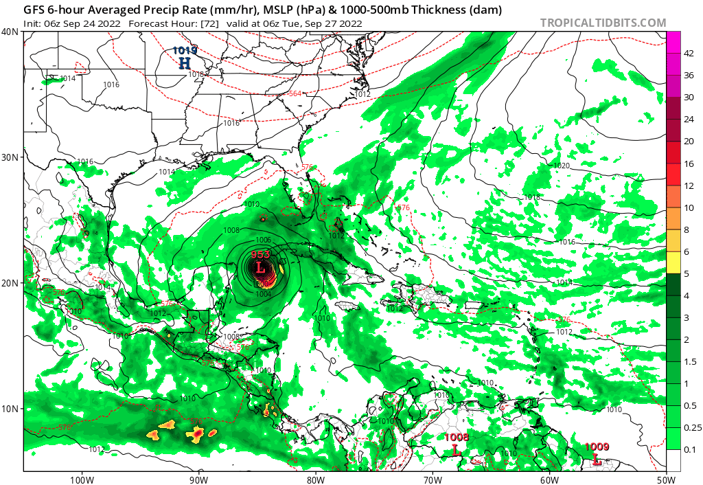
I just don't buy that rapid decrease in MB/intensification on the GFS, 00Z Euro has it getting into southern GA as a minor Cat 1/high end TS and that's with 200 miles north tracking through FL Peninsula.
5 likes
Once I see the REDS and GREENS Converge on a Base Velocity. ... I'm There!!
This is NOT an Official Forecast....Just my Opinion. For official information, please refer to the NHC and NWS products.
HIGHLIGHTS : '13 El Reno Tornado : 2013 Storm Chaser Tour, Joaquin; SC flood event, Matthew '16, Lowcountry Snow storm Jan '18
This is NOT an Official Forecast....Just my Opinion. For official information, please refer to the NHC and NWS products.
HIGHLIGHTS : '13 El Reno Tornado : 2013 Storm Chaser Tour, Joaquin; SC flood event, Matthew '16, Lowcountry Snow storm Jan '18

Re: ATL: IAN - Models
The hurricane models have been trending weaker in the WCar because Ian spends more time trying to put itself together each run, and even when there is an eyewall, intensification is rather slow. Ian only gets down to the low 970s by the time it makes landfall in Cuba on Tuesday morning on the 06z HMON.
2 likes
Irene '11 Sandy '12 Hermine '16 5/15/2018 Derecho Fay '20 Isaias '20 Elsa '21 Henri '21 Ida '21
I am only a meteorology enthusiast who knows a decent amount about tropical cyclones. Look to the professional mets, the NHC, or your local weather office for the best information.
I am only a meteorology enthusiast who knows a decent amount about tropical cyclones. Look to the professional mets, the NHC, or your local weather office for the best information.

-
Ivanhater

- Storm2k Moderator

- Posts: 10852
- Age: 37
- Joined: Fri Jul 01, 2005 8:25 am
- Location: Pensacola
Re: ATL: IAN - Models
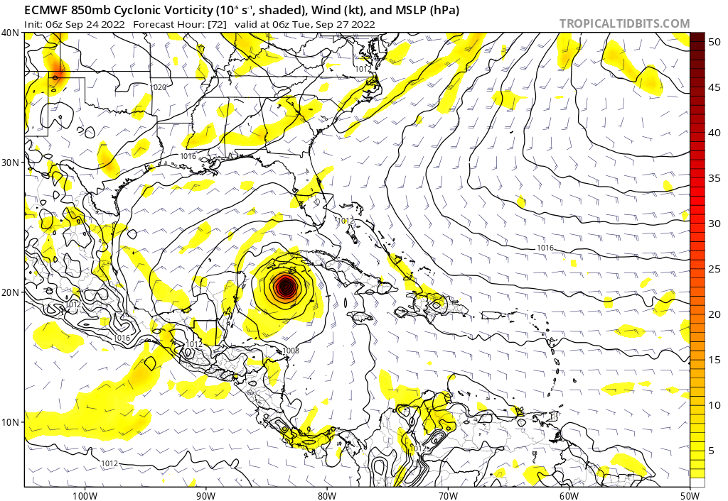
Keep in mind, Recon has fixed a center more than a full degree South of initialization
3 likes
Michael

Re: ATL: IAN - Models
Don't throw out the 0z Euro's forecast track run out the window, it picked up nicely the reformation further south and west this morning.

8 likes
-
Iceresistance

- Category 5

- Posts: 8915
- Age: 20
- Joined: Sat Oct 10, 2020 9:45 am
- Location: Tecumseh, OK/Norman, OK
Re: ATL: IAN - Models
pgoss11 wrote:pgoss11 wrote:Hurricaneman wrote:Just adjusting to the center relocation
Do center reformations ever show up on modeling?
Yes, but it does not happen very often.
1 likes
Bill 2015 & Beta 2020
Winter 2020-2021
All observations are in Tecumseh, OK unless otherwise noted.
Winter posts are focused mainly for Oklahoma & Texas.
Take any of my forecasts with a grain of salt, refer to the NWS, SPC, and NHC for official information
Never say Never with weather! Because ANYTHING is possible!
Winter 2020-2021
All observations are in Tecumseh, OK unless otherwise noted.
Winter posts are focused mainly for Oklahoma & Texas.
Take any of my forecasts with a grain of salt, refer to the NWS, SPC, and NHC for official information
Never say Never with weather! Because ANYTHING is possible!
-
Jevo

- S2K Supporter

- Posts: 1729
- Age: 46
- Joined: Tue Aug 03, 2004 8:45 pm
- Location: The Flemish Cap
- Contact:
Re: ATL: IAN - Models
Looks like the early models initiated a degree north of the recon plot. Not sure if it will have an impact, just something to note
2 likes
Re: ATL: IAN - Models
Jevo wrote:Looks like the early models initiated a degree north of the recon plot. Not sure if it will have an impact, just something to note
0z & 06z Euro did a nice job of forecasting the SW jog or reformation further south & west this morning, is spot on so I am not throwing it out the window.
1 likes


Re: ATL: IAN - Models
Waking up to more model inconsistency!  There does appear to be a westward trend so far. Nervously awaiting each new suite on the west coast of Florida.
3 likes


Re: ATL: IAN - Models
06z Euro stronger and about 15-20 miles west of its 0z run track through 90 hours at the end of its run. It also did a nice job of reformation or jog further S & W this morning.

3 likes
-
tolakram
- Admin

- Posts: 19165
- Age: 60
- Joined: Sun Aug 27, 2006 8:23 pm
- Location: Florence, KY (name is Mark)
Re: ATL: IAN - Models
HWRF

1 likes
M a r k
- - - - -
Join us in chat: Storm2K Chatroom Invite. Android and IOS apps also available.
The posts in this forum are NOT official forecasts and should not be used as such. Posts are NOT endorsed by any professional institution or STORM2K.org. For official information and forecasts, please refer to NHC and NWS products.
-
Ivanhater
- Storm2k Moderator
- Posts: 10852
- Age: 37
- Joined: Fri Jul 01, 2005 8:25 am
- Location: Pensacola
Re: ATL: IAN - Models
Big shift North and West on TVCN...Nhc cone will likely be adjusted more the the north and west toward big bend
12Z

Sent from my LM-G900TM using Tapatalk
12Z
Sent from my LM-G900TM using Tapatalk
1 likes
Michael

Re: ATL: IAN - Models
Based purely on a gut instinct I feel like the windshield wiping has reached its peak now and we'll see slight east shifts in the next model runs. This is partially based on the fact that the Euro showed the SW center relocation and still went quite far east with respect to the other models. If so a Tampa landfall sounds like a possible scenario. But in its short life so far Ian has been one of the most difficult storms to track this season so there's still a lot of uncertainty.
1 likes

Who is online
Users browsing this forum: No registered users and 23 guests