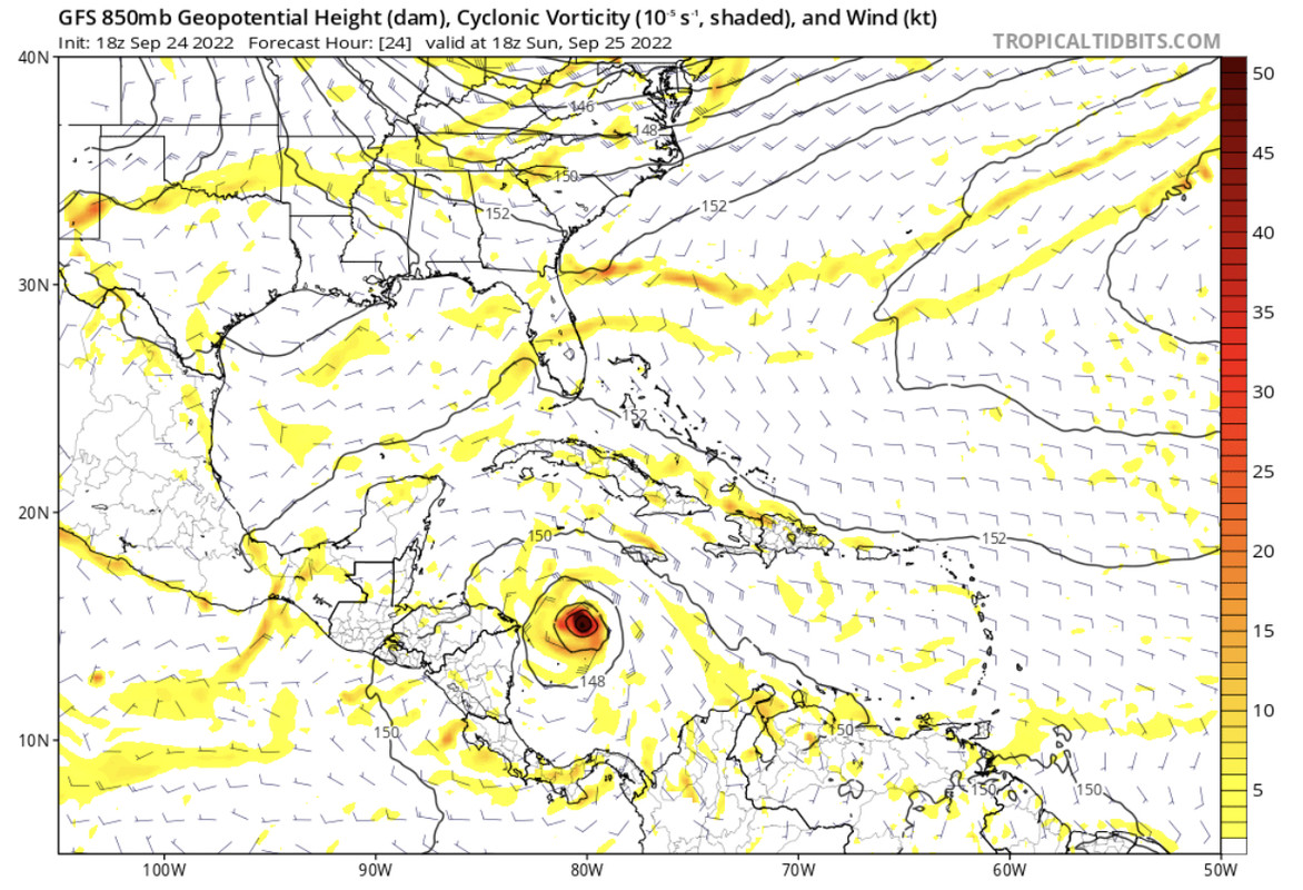
18z GFS had Ian moving above 15N in 24 hours. Ian is there now, curious to see if that effects the 00z outcome.
Moderator: S2k Moderators


gatorcane wrote:Thanks yeah the EPS really is similar to the 12Z so hasn’t moved much.
Blown Away wrote:[url]https://i.postimg.cc/wTsGqCbN/0-A6499-DE-FF80-425-C-A55-C-8-BF23-F6-F51-DF.jpg [/url]
18z GFS had Ian moving above 15N in 24 hours. Ian is there now, curious to see if that effects the 00z outcome.


caneman wrote:Blown Away wrote:[url]https://i.postimg.cc/wTsGqCbN/0-A6499-DE-FF80-425-C-A55-C-8-BF23-F6-F51-DF.jpg [/url]
18z GFS had Ian moving above 15N in 24 hours. Ian is there now, curious to see if that effects the 00z outcome.
It absolutely should. Tells me the GFS is and has been way off. I'm always always about model blend but I really don't know what the he!! GFS is doing with this system.
jlauderdal wrote:A few days might be a bit late for prepsStormcenter wrote:I just don't believe the NHC has a good hold on where Ian is going and probably won't for another few days. Way too many things
that can change to affect the final track and the models obviously are the same way now.

Blown Away wrote:[url]https://i.postimg.cc/cChBDcDd/ecmwf-uv10-watl-trend.gif [/url]
18z ECMWF… Trend, NE and faster.


Blown Away wrote:[url]https://i.postimg.cc/wTsGqCbN/0-A6499-DE-FF80-425-C-A55-C-8-BF23-F6-F51-DF.jpg [/url]
18z GFS had Ian moving above 15N in 24 hours. Ian is there now, curious to see if that effects the 00z outcome.
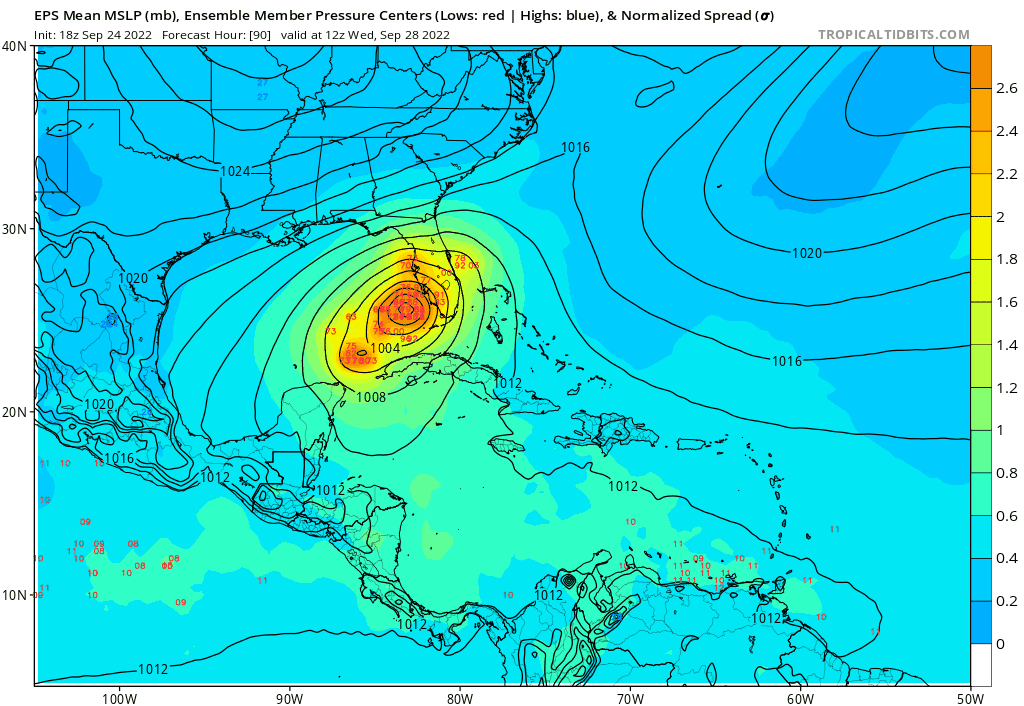
PandaCitrus wrote:The 18z Euro Ensemble Mean is a worst case surge scenario that would lay waste to low lying areas of Pinellas, Pasco, Hernando, Citrus, and Levy counties. It could be Katrina like surge destruction if it hit as a Cat 4+. A lot of SLOSH maps have 20 feet of surge potential in a Cat 4+

 Hurricanes: Andrew 1992 - Irene 1999 - Frances 2004 - Jeanne 2004 - Katrina 2005 - Wilma 2005 - Matthew 2016 - Irma 2017 - Ian 2022 - Nicole 2022
PandaCitrus wrote:The 18z Euro Ensemble Mean is a worst case surge scenario that would lay waste to low lying areas of Pinellas, Pasco, Hernando, Citrus, and Levy counties. It could be Katrina like surge destruction if it hit as a Cat 4+. A lot of SLOSH maps have 20 feet of surge potential in a Cat 4+blp wrote:gatorcane wrote:Anybody have the 18Z Euro ensembles?
Katrina’s wind field size after it’s EWRC and large size overall led to that catastrophic surge and flooding. This needs consideration when making that comparison
https://i.ibb.co/m6T0nZK/AL09.gif

Hypercane_Kyle wrote:Blown Away wrote:[url]https://i.postimg.cc/wTsGqCbN/0-A6499-DE-FF80-425-C-A55-C-8-BF23-F6-F51-DF.jpg [/url]
18z GFS had Ian moving above 15N in 24 hours. Ian is there now, curious to see if that effects the 00z outcome.
GFS is latching onto the wrong center, resulting in a more southern path IMHO.


Users browsing this forum: No registered users and 47 guests


