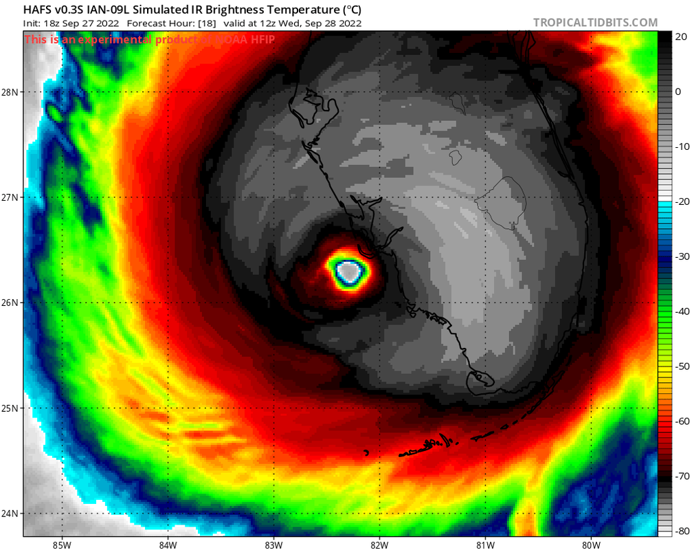
ATL: IAN - Models

Moderator: S2k Moderators

Message
Author
GTStorm
Tropical Storm
Tropical Storm
Posts: 214
Joined: Sat Sep 04, 2004 8:44 pm
Location: Savannah

Re: ATL: IAN - Models

#3341 Postby GTStorm » Tue Sep 27, 2022 8:36 pm

tolakram wrote:
Vdogg wrote:That east trend has been absolutely relentless. All the major models now show it crossing into the Atlantic.


ICON is the furthest right now, showing a SC landfall. It's the one model we don't have verification for (I can't find it) so I'm very interested in seeing if all the other models trend up the east coast.


So I suppose that normally, you'd see something like this in this time of year just take off NE and get on out of here. What do the models see that want to drive it back toward the coast?
6 likes   

User avatar
SFLcane
S2K Supporter
S2K Supporter
Posts: 9606
Age: 46
Joined: Sat Jun 05, 2010 1:44 pm
Location: Lake Worth Florida

Re: ATL: IAN - Models

#3342 Postby SFLcane » Tue Sep 27, 2022 8:37 pm

Image
6 likes   

User avatar
StormTracker
S2K Supporter
S2K Supporter
Posts: 2902
Age: 57
Joined: Thu Jun 29, 2006 6:06 am
Location: Quail Heights(Redlands), FL.

Re: ATL: IAN - Models

#3343 Postby StormTracker » Tue Sep 27, 2022 8:47 pm

:eek:


Let's hope not!
1 likes   
Something's wrong when you regret, things that haven't happened yet!

User avatar
SFLcane
S2K Supporter
S2K Supporter
Posts: 9606
Age: 46
Joined: Sat Jun 05, 2010 1:44 pm
Location: Lake Worth Florida

Re: ATL: IAN - Models

#3344 Postby SFLcane » Tue Sep 27, 2022 8:49 pm

StormTracker wrote::eek:


Let's hope not!


Andy’s model
1 likes   

User avatar
SFLcane
S2K Supporter
S2K Supporter
Posts: 9606
Age: 46
Joined: Sat Jun 05, 2010 1:44 pm
Location: Lake Worth Florida

Re: ATL: IAN - Models

#3345 Postby SFLcane » Tue Sep 27, 2022 8:57 pm

Image
2 likes   

Vdogg
Category 2
Category 2
Posts: 619
Joined: Wed Aug 31, 2016 9:56 am

Re: ATL: IAN - Models

#3346 Postby Vdogg » Tue Sep 27, 2022 9:01 pm

GTStorm wrote:
tolakram wrote:
Vdogg wrote:That east trend has been absolutely relentless. All the major models now show it crossing into the Atlantic.


ICON is the furthest right now, showing a SC landfall. It's the one model we don't have verification for (I can't find it) so I'm very interested in seeing if all the other models trend up the east coast.


So I suppose that normally, you'd see something like this in this time of year just take off NE and get on out of here. What do the models see that want to drive it back toward the coast?
Usually if there’s a cold front it just bounces it OTS anywhere from a NE to E trajectory. Actually happens with the majority of our storms up here, but apparently the ridge is blocking it.
1 likes   

StAuggy
Tropical Storm
Tropical Storm
Posts: 119
Age: 44
Joined: Sat Sep 14, 2019 10:48 am
Location: St Augustine

Re: ATL: IAN - Models

#3347 Postby StAuggy » Tue Sep 27, 2022 10:00 pm

Some of these model runs have Ian just off the NE FL coast along the 980mb range. That’s basically still a Cat 1 right? It’s trajectory and forward speed across the state as well as possible increased strength at landfall have these models hinting that it won’t weaken to a TS am I seeing that correctly?
1 likes   

jdjaguar
Category 2
Category 2
Posts: 505
Joined: Fri Aug 26, 2005 12:07 pm
Location: Jacksonville Beach, FL

Re: ATL: IAN - Models

#3348 Postby jdjaguar » Tue Sep 27, 2022 10:06 pm

StAuggy wrote:Some of these model runs have Ian just off the NE FL coast along the 980mb range. That’s basically still a Cat 1 right? It’s trajectory and forward speed across the state as well as possible increased strength at landfall have these models hinting that it won’t weaken to a TS am I seeing that correctly?

hopefully not.
1 likes   

User avatar
CronkPSU
S2K Supporter
S2K Supporter
Posts: 1900
Joined: Sun Aug 07, 2005 10:44 pm
Location: Avalon Park, FL

Re: ATL: IAN - Models

#3349 Postby CronkPSU » Tue Sep 27, 2022 10:37 pm

alright time for the 0z models to start rolling in...always funny how this board is red hot for days and the discussion board isn't until 24 hours before landfall and then this just goes dead

thought with the possible Carolinas second hit, more people might stick around in here for a few more days
Last edited by CronkPSU on Tue Sep 27, 2022 10:41 pm, edited 1 time in total.
9 likes   
Just like Jon Snow..."I know nothing" except what I know, and most of what I know is gathered by the fine people of the NHC

shah83
Category 1
Category 1
Posts: 269
Joined: Sun Jul 31, 2016 4:55 pm

Re: ATL: IAN - Models

#3350 Postby shah83 » Tue Sep 27, 2022 10:40 pm

0z Icon run is sort of impressive, slightly to the left of 18z, but...hmm, concerning run in the Atlantic.
3 likes   

WilmingtonSandbar
S2K Supporter
S2K Supporter
Posts: 503
Joined: Sun Aug 29, 2010 12:11 pm
Location: Southport, NC

Re: ATL: IAN - Models

#3351 Postby WilmingtonSandbar » Tue Sep 27, 2022 10:43 pm

GTStorm wrote:
tolakram wrote:
Vdogg wrote:That east trend has been absolutely relentless. All the major models now show it crossing into the Atlantic.


ICON is the furthest right now, showing a SC landfall. It's the one model we don't have verification for (I can't find it) so I'm very interested in seeing if all the other models trend up the east coast.


So I suppose that normally, you'd see something like this in this time of year just take off NE and get on out of here. What do the models see that want to drive it back toward the coast?


There's a high pressure system over the Atlantic, that has been there most of the summer, that wants to steer Ian around it to the NW. To me, it just a matter of if the high pressure system retrogrades to the east, and how far, that will effect how far north Ian goes before it turn to the westerly directions, and a second landfall.
3 likes   
Diana X2 (look it up), Bertha, Fran, Bonnie, Floyd, Dennis, Charley, Ophelia, Ernesto, Irene, Matthew, And Florence

WilmingtonSandbar
S2K Supporter
S2K Supporter
Posts: 503
Joined: Sun Aug 29, 2010 12:11 pm
Location: Southport, NC

Re: ATL: IAN - Models

#3352 Postby WilmingtonSandbar » Tue Sep 27, 2022 10:46 pm

Vdogg wrote:
GTStorm wrote:
tolakram wrote:
ICON is the furthest right now, showing a SC landfall. It's the one model we don't have verification for (I can't find it) so I'm very interested in seeing if all the other models trend up the east coast.


So I suppose that normally, you'd see something like this in this time of year just take off NE and get on out of here. What do the models see that want to drive it back toward the coast?
Usually if there’s a cold front it just bounces it OTS anywhere from a NE to E trajectory. Actually happens with the majority of our storms up here, but apparently the ridge is blocking it.


The cold front dropped into the Gulf south of Louisiana today, this is what it is going to bounce off of and turn it ENE over Florida.
5 likes   
Diana X2 (look it up), Bertha, Fran, Bonnie, Floyd, Dennis, Charley, Ophelia, Ernesto, Irene, Matthew, And Florence

WilmingtonSandbar
S2K Supporter
S2K Supporter
Posts: 503
Joined: Sun Aug 29, 2010 12:11 pm
Location: Southport, NC

Re: ATL: IAN - Models

#3353 Postby WilmingtonSandbar » Tue Sep 27, 2022 10:49 pm

CronkPSU wrote:alright time for the 0z models to start rolling in...always funny how this board is red hot for days and the discussion board isn't until 24 hours before landfall and then this just goes dead

thought with the possible Carolinas second hit, more people might stick around in here for a few more days


Most of the members(from my understanding) live in Florida. So, after it passes them, the boards dry up a bit. I don't fault them. Most of them are sleeping for a few days to recover from the build up to Florida. I do the same after a storm passes NC.
8 likes   
Diana X2 (look it up), Bertha, Fran, Bonnie, Floyd, Dennis, Charley, Ophelia, Ernesto, Irene, Matthew, And Florence

User avatar
jdray
Category 3
Category 3
Posts: 846
Joined: Tue Aug 31, 2004 10:07 pm
Location: NE Florida

Re: ATL: IAN - Models

#3354 Postby jdray » Tue Sep 27, 2022 10:51 pm

CronkPSU wrote:alright time for the 0z models to start rolling in...always funny how this board is red hot for days and the discussion board isn't until 24 hours before landfall and then this just goes dead

thought with the possible Carolinas second hit, more people might stick around in here for a few more days


I've always lurked and read more than posted, but it definitely does drop off as soon as landfall is near. I think many people see the models just for storm strength and path, but forget about the rest of what the model threads is for.
5 likes   

wx98
Category 5
Category 5
Posts: 1218
Joined: Sat Aug 25, 2018 9:24 pm

Re: ATL: IAN - Models

#3355 Postby wx98 » Tue Sep 27, 2022 11:02 pm

jdray wrote:
CronkPSU wrote:alright time for the 0z models to start rolling in...always funny how this board is red hot for days and the discussion board isn't until 24 hours before landfall and then this just goes dead

thought with the possible Carolinas second hit, more people might stick around in here for a few more days


I've always lurked and read more than posted, but it definitely does drop off as soon as landfall is near. I think many people see the models just for storm strength and path, but forget about the rest of what the model threads is for.


I like to lurk in the models thread during the big events as well, but I like to read through every post in the discussion thread. So I spend way more time there and just stop in here to get the latest info.
5 likes   

LarryWx
Category 5
Category 5
Posts: 5699
Joined: Sun Sep 07, 2003 2:04 pm
Location: GA

Re: ATL: IAN - Models

#3356 Postby LarryWx » Tue Sep 27, 2022 11:23 pm

0Z UKMET: landfall a bit north of the 12Z and is near Punta Gorda. Exits FL at Cape Canaveral. Then landfall a little north of Charleston:

MET OFFICE TROPICAL CYCLONE GUIDANCE FOR NORTH-EAST PACIFIC AND ATLANTIC

GLOBAL MODEL DATA TIME 0000UTC 28.09.2022

HURRICANE IAN ANALYSED POSITION : 24.3N 83.0W

ATCF IDENTIFIER : AL092022

LEAD CENTRAL MAXIMUM WIND
VERIFYING TIME TIME POSITION PRESSURE (MB) SPEED (KNOTS)
-------------- ---- -------- ------------- -------------
0000UTC 28.09.2022 0 24.3N 83.0W 961 72
1200UTC 28.09.2022 12 26.0N 82.6W 959 83
0000UTC 29.09.2022 24 27.2N 81.8W 979 58
1200UTC 29.09.2022 36 28.1N 81.0W 990 47
0000UTC 30.09.2022 48 29.4N 79.9W 986 60
1200UTC 30.09.2022 60 31.1N 79.5W 984 51
0000UTC 01.10.2022 72 33.4N 79.7W 986 40
1200UTC 01.10.2022 84 35.0N 80.6W 1001 28
0000UTC 02.10.2022 96 36.0N 80.1W 1006 20
1200UTC 02.10.2022 108 CEASED TRACKING
2 likes   
Personal Forecast Disclaimer:
The posts in this forum are NOT official forecasts and should not be used as such. They are just the opinion of the poster and may or may not be backed by sound meteorological data. They are NOT endorsed by any professional institution or storm2k.org. For official information, please refer to the NHC and NWS products.

caneman
Category 5
Category 5
Posts: 1178
Joined: Fri Sep 05, 2014 5:44 am
Location: Clearwater Beach, Fl

Re: ATL: IAN - Models

#3357 Postby caneman » Tue Sep 27, 2022 11:33 pm

Did GFS run already? It looked like it to me? If so, did it tick North to Venice or Sarasota? Couldn't tell with these aging eyes. Lol
0 likes   

User avatar
PTPatrick
Category 5
Category 5
Posts: 1827
Joined: Sat Jun 12, 2004 8:38 am

Re: ATL: IAN - Models

#3358 Postby PTPatrick » Wed Sep 28, 2022 12:00 am

0z are in…
Gfs not much change, landfall around Venice
Hwrf shifted a tad back north and now tracks directly over Sarasota
CMC splits the difference with a landfall a hair north of GFS, osprey?
HMON is pretty similar to CMC I think between Sarasota and Venice

Hmon and hwrf actually both shifted very slightly left, I think. It’ll be a big storm so likely immaterial shifts.
2 likes   

caneman
Category 5
Category 5
Posts: 1178
Joined: Fri Sep 05, 2014 5:44 am
Location: Clearwater Beach, Fl

Re: ATL: IAN - Models

#3359 Postby caneman » Wed Sep 28, 2022 12:02 am

PTPatrick wrote:0z are in…
Gfs not much change, landfall around Venice
Hwrf shifted a tad back north and now tracks directly over Sarasota
CMC splits the difference with a landfall a hair north of GFS, osprey?
HMON is pretty similar to CMC I think between Sarasota and Venice

Hmon and hwrf actually both shifted very slightly left, I think. It’ll be a big storm so likely immaterial shifts.


I thought I saw Northward too. Last hour or so on radar there is also a clear due North movement.
0 likes   

tolakram
Admin
Admin
Posts: 19165
Age: 60
Joined: Sun Aug 27, 2006 8:23 pm
Location: Florence, KY (name is Mark)

Re: ATL: IAN - Models

#3360 Postby tolakram » Wed Sep 28, 2022 1:02 am

GFS further up the Atlantic coast now, following the ICON.

Image
1 likes   
M a r k
- - - - -
Join us in chat: Storm2K Chatroom Invite. Android and IOS apps also available.

The posts in this forum are NOT official forecasts and should not be used as such. Posts are NOT endorsed by any professional institution or STORM2K.org. For official information and forecasts, please refer to NHC and NWS products.


Return to “2022”

Who is online

Users browsing this forum: No registered users and 48 guests