ATL: IAN - Models

Moderator: S2k Moderators

Message
Author
User avatar
eastcoastFL
Category 5
Category 5
Posts: 3437
Age: 42
Joined: Thu Apr 12, 2007 12:29 pm
Location: Palm City, FL

Re: ATL: IAN - Models

#3081 Postby eastcoastFL » Mon Sep 26, 2022 11:28 pm

Poonwalker wrote:Omg. Iam actually going to get flooded if that happens. Can someone verify if that’s possible?

If you look at Harvey it's certainly possible. It's like a once in a lifetime event but possible. Let's hope it doesn't play out this way. That's a crazy stall.
3 likes   
Personal Forecast Disclaimer:
The posts in this forum are NOT official forecast and should not be used as such. They are just the opinion of the poster and may or may not be backed by sound meteorological data. They are NOT endorsed by any professional institution or storm2k.org. For official information, please refer to the NHC and NWS products.

Hurricane Mike
Category 2
Category 2
Posts: 562
Joined: Tue Apr 10, 2018 7:44 am

Re: ATL: IAN - Models

#3082 Postby Hurricane Mike » Mon Sep 26, 2022 11:29 pm

If anything is different, Florida is much more accustomed to the heavy rain than Texas was with Harvey. Doesn't make it any better, though.
1 likes   

Knight85
Tropical Wave
Tropical Wave
Posts: 5
Joined: Fri Sep 23, 2022 2:59 pm
Location: Safety Harbor, FL

Re: ATL: IAN - Models

#3083 Postby Knight85 » Mon Sep 26, 2022 11:29 pm

NDG wrote:I don't know what would be worst north of Tampa Bay, a storm surge or 40"+ of rain if Ian stall to the south.


For much of Tampa, the rain might be worse. Not the coastal areas of course, but large parts of Tampa are notorious for becoming navigable waterways after a strong thunderstorm, not to mention that kind of rain.
Last edited by Knight85 on Mon Sep 26, 2022 11:30 pm, edited 1 time in total.
2 likes   

User avatar
tronbunny
S2K Supporter
S2K Supporter
Posts: 1543
Joined: Wed Sep 01, 2004 1:18 am
Location: Central FL

Re: ATL: IAN - Models

#3084 Postby tronbunny » Mon Sep 26, 2022 11:29 pm

Let me see, reduced coastal surge threat of 10' to 3' of further spread rain. I'm wondering if this is out to lunch. Now I'm just more confused :double:
cheezyWXguy wrote:
eastcoastFL wrote:
cheezyWXguy wrote:Positive trends so far, but tampa is by no means out of the woods yet in regard to surge. I’m hesitant to lean into a further south landfall, not only because of the impacts of small deviations/wobbles, but also because a stronger storm will have a tendency to try and stay a little west of the path. It bothers me that both the icon and gfs initialized too weak and still bring this as close as they do to Tampa


What is positive about the trend, is it the decreased surge threat?

Yeah the surge would be reduced to that area, and I should have pointed out that it’s a positive trend for tampa specifically. Though as others have pointed out, it’s kind of a trade off with the rain. At this point, I view any deviation from the 12z doomsday scenario as positive, even though it’s still terrible
1 likes   

LarryWx
Category 5
Category 5
Posts: 5699
Joined: Sun Sep 07, 2003 2:04 pm
Location: GA

Re: ATL: IAN - Models

#3085 Postby LarryWx » Mon Sep 26, 2022 11:30 pm

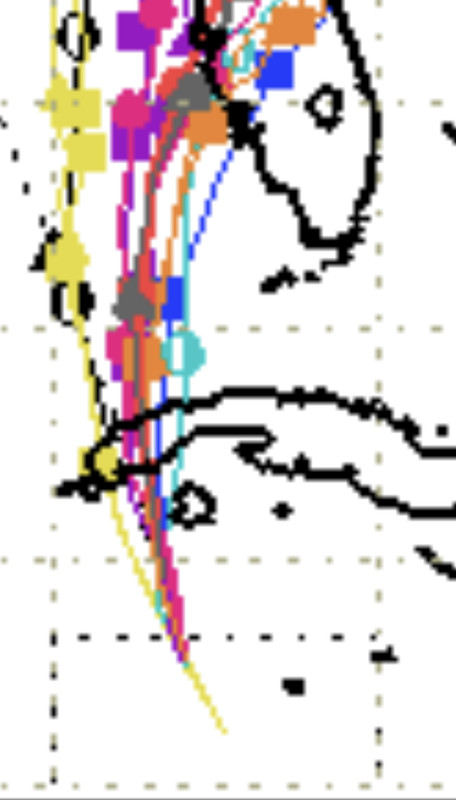
AdamFirst wrote:anyone have the UKM plot? They've consistently been on the southern end of the envelope and I'd like to see where that one ends up.


0Z UKMET: even further south just N of Ft. Myers, exits FL near Cape Canaveral, and then 2nd landfall Charleston:


MET OFFICE TROPICAL CYCLONE GUIDANCE FOR NORTH-EAST PACIFIC AND ATLANTIC

GLOBAL MODEL DATA TIME 0000UTC 27.09.2022

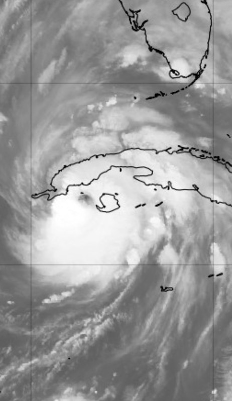
HURRICANE IAN ANALYSED POSITION : 20.8N 83.3W

ATCF IDENTIFIER : AL092022

LEAD CENTRAL MAXIMUM WIND
VERIFYING TIME TIME POSITION PRESSURE (MB) SPEED (KNOTS)
-------------- ---- -------- ------------- -------------
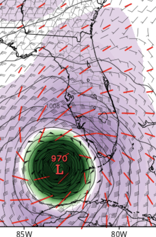
0000UTC 27.09.2022 0 20.8N 83.3W 984 51
1200UTC 27.09.2022 12 22.8N 83.4W 985 47
0000UTC 28.09.2022 24 24.4N 83.2W 983 49
1200UTC 28.09.2022 36 26.1N 82.5W 982 59
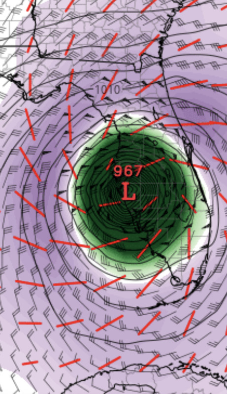
0000UTC 29.09.2022 48 27.4N 81.6W 991 45
1200UTC 29.09.2022 60 28.4N 80.6W 995 46
0000UTC 30.09.2022 72 29.4N 80.4W 993 53
1200UTC 30.09.2022 84 30.5N 79.9W 993 44
0000UTC 01.10.2022 96 33.0N 80.1W 990 38
1200UTC 01.10.2022 108 35.0N 81.1W 999 28
0000UTC 02.10.2022 120 36.4N 80.6W 1005 21
1200UTC 02.10.2022 132 36.8N 79.9W 1008 23
0000UTC 03.10.2022 144 CEASED TRACKING
2 likes   
Personal Forecast Disclaimer:
The posts in this forum are NOT official forecasts and should not be used as such. They are just the opinion of the poster and may or may not be backed by sound meteorological data. They are NOT endorsed by any professional institution or storm2k.org. For official information, please refer to the NHC and NWS products.

MrJames
Tropical Storm
Tropical Storm
Posts: 183
Joined: Fri Sep 10, 2004 11:56 am
Location: Jax, FL

Re: ATL: IAN - Models

#3086 Postby MrJames » Mon Sep 26, 2022 11:31 pm

CMC shifted east. Just offshore Tampa with landfall near Cedar Key heading N.

00z UKMET has landfall near Port Charlotte and crosses central Florida then heads for Charleston.
2 likes   

User avatar
Meteorcane
Category 2
Category 2
Posts: 541
Joined: Thu Jul 21, 2011 6:49 am
Location: North Platte Nebraska

Re: ATL: IAN - Models

#3087 Postby Meteorcane » Mon Sep 26, 2022 11:32 pm

Poonwalker wrote:Omg. Iam actually going to get flooded if that happens. Can someone verify if that’s possible?


It is a very tricky setup as evidenced by the fact you have a camp of models (UKMET/ICON/latest Euro) with a fairly clean and quick eastward trek across Florida as the system is faster and further east and is easily picked up by the trough, while the GFS/CMC have a slower and slightly further west system which gets left behind by the trough resulting in a period of weak steering and a near stall or slow drift northward (The GFS stalls just inland, while the CMC stalls just offshore). You can tell it will be a close shave by the fact that roughly 48 hours out there is still 2 fairly disparate camps. The trend is a bit further east with the system (likely because the eastern CONUS trough a bit more amplified than some models progged a few days ago) which may slightly favor a cleaner interaction with the trough, but I wouldn't necessarily throw out the stall solution just yet.
4 likes   

User avatar
Stormgodess
Tropical Storm
Tropical Storm
Posts: 219
Joined: Mon Sep 14, 2020 1:31 am

Re: ATL: IAN - Models

#3088 Postby Stormgodess » Mon Sep 26, 2022 11:34 pm

Poonwalker wrote:Omg. Iam actually going to get flooded if that happens. Can someone verify if that’s possible?


In August 2016, my area in SE Louisiana got 40+ inches of rain in just over 24 hrs from a simple summer storm. Yes it's possible. It's the type of rainfall that leaves people on their roofs waiting for rescue, in areas rhat have never flooded before.

So please make plans in advance. Or leave if you can.
7 likes   

User avatar
SoupBone
Category 5
Category 5
Posts: 3073
Joined: Tue Sep 20, 2005 5:24 pm

Re: ATL: IAN - Models

#3089 Postby SoupBone » Mon Sep 26, 2022 11:36 pm

Poonwalker wrote:Omg. Iam actually going to get flooded if that happens. Can someone verify if that’s possible?


Well lots of people laughed off models when they showed these kinds of numbers for Hurricane Harvey. We all know how that turned out.
6 likes   
Personal Forecast Disclaimer:
The posts in this forum are NOT official forecast and should not be used as such. They are just the opinion of the poster and may or may not be backed by sound meteorological data. They are NOT endorsed by any professional institution or storm2k.org. For official information, please refer to the NHC and NWS products.

Craters
Category 1
Category 1
Posts: 349
Joined: Sat Aug 24, 2013 2:34 pm
Location: Alvin, TX (south of Houston)

Re: ATL: IAN - Models

#3090 Postby Craters » Mon Sep 26, 2022 11:46 pm

SoupBone wrote:
Poonwalker wrote:Omg. Iam actually going to get flooded if that happens. Can someone verify if that’s possible?


Well lots of people laughed off models when they showed these kinds of numbers for Hurricane Harvey. We all know how that turned out.

A good rule of thumb for rainfall totals in tropical systems is to take the forward motion of the storm in miles per hour and divide it into 100. So, if the net speed of the system is 12 mph and it's passing near you, you can expect a total of around 8" of rain or so. Not an exact calculation, but I have verified that it gives surprisingly accurate estimates. For instance, Harvey was moving at around 3 mph here in SE Texas, and we got just about 33" in Alvin.

If I recall correctly, I first heard it when John Hope, God bless him, mentioned it on The Weather Channel.
8 likes   
Nothing that I post here should ever be treated as a forecast or anything resembling one. Please check with your local NWS office or the NHC for forecasts, watches, and warnings.

User avatar
skyline385
Category 5
Category 5
Posts: 2444
Age: 33
Joined: Wed Aug 26, 2020 11:15 pm
Location: Palm Beach County FL

Re: ATL: IAN - Models

#3091 Postby skyline385 » Mon Sep 26, 2022 11:49 pm

SoupBone wrote:
Poonwalker wrote:Omg. Iam actually going to get flooded if that happens. Can someone verify if that’s possible?


Well lots of people laughed off models when they showed these kinds of numbers for Hurricane Harvey. We all know how that turned out.


Both models also showed 20+ inches of rain from Fiona as well. I posted them in the models thread and they were pretty damn accurate at the end.
1 likes   

User avatar
galaxy401
Category 5
Category 5
Posts: 2299
Age: 28
Joined: Sat Aug 25, 2012 9:04 pm
Location: Casa Grande, Arizona

Re: ATL: IAN - Models

#3092 Postby galaxy401 » Mon Sep 26, 2022 11:54 pm

Eek that GFS rainfall graphic is a complete nightmare over at Tampa! :eek: This could be a 1-in-100 year event for them...
1 likes   
Got my eyes on moving right into Hurricane Alley: Florida.

User avatar
Meteorcane
Category 2
Category 2
Posts: 541
Joined: Thu Jul 21, 2011 6:49 am
Location: North Platte Nebraska

Re: ATL: IAN - Models

#3093 Postby Meteorcane » Tue Sep 27, 2022 12:07 am

Best satellite presentation of its lifetime right now... AdjT up to 5.7... wouldn't be surprised if they nudge it to major at 2am.

Image
1 likes   

User avatar
Clearcloudz
Category 2
Category 2
Posts: 523
Joined: Sun Jun 10, 2018 1:46 pm
Location: Rosenberg TX

Re: ATL: IAN - Models

#3094 Postby Clearcloudz » Tue Sep 27, 2022 12:07 am

The bigger story will be the insurance nightmare that follows this storm and most people don't carry freshwater flood insurance like the coastal communities do.
2 likes   

LARanger
Tropical Depression
Tropical Depression
Posts: 82
Joined: Wed Oct 07, 2020 12:45 pm

Re: ATL: IAN - Models

#3095 Postby LARanger » Tue Sep 27, 2022 12:26 am

Stormgodess wrote:
Poonwalker wrote:Omg. Iam actually going to get flooded if that happens. Can someone verify if that’s possible?


In August 2016, my area in SE Louisiana got 40+ inches of rain in just over 24 hrs from a simple summer storm. Yes it's possible. It's the type of rainfall that leaves people on their roofs waiting for rescue, in areas rhat have never flooded before.

So please make plans in advance. Or leave if you can.


Seconded. As I related recently:

The 2016 Louisiana flooding, caused by what was basically a stationary inland hurricane, dropped around 7 trillion gallons on around a third of the state. That was up to 30"+ of rain in places over an area large enough to cover (and defeat) river systems, leaving folks that had barely ever seen so much as an overtopped ditch with water lapping at the ceiling. A year later, Harvey doubled the Louisiana 2016 event in size and intensity, doubling or tripling the total rainfall volume (though you can find some wilder estimates from the time suggesting as high as 33 trillion gallons), and resulting in literally five feet of rain in places. That's sufficient to not just defeat river systems, but basically to defeat drainage *as a concept*.
2 likes   
Baton Rouge area cyclone dilettante, PSWAGGER* tropical weather & hydrology model developer
(* Pseudo-Scientific Wild-A** Guesses Generally Expressed Ridiculously)
The GFDL would've had all this figured out by now.

User avatar
TheDreamTraveler
Category 2
Category 2
Posts: 633
Joined: Sun Aug 22, 2010 3:10 am
Location: PA

Re: ATL: IAN - Models

#3096 Postby TheDreamTraveler » Tue Sep 27, 2022 12:28 am

SoupBone wrote:
Poonwalker wrote:Omg. Iam actually going to get flooded if that happens. Can someone verify if that’s possible?


Well lots of people laughed off models when they showed these kinds of numbers for Hurricane Harvey. We all know how that turned out.


Same goes for the absurd flooding from Florence in 2018. It was showing 30-40 inches of rain and people couldn't believe it. But Harvey had just happened the year prior so I think more people weren't as skeptical. These storms really like to slow down and stall more often nowadays which is something that's become very noticeable
2 likes   

User avatar
Blown Away
S2K Supporter
S2K Supporter
Posts: 9861
Joined: Wed May 26, 2004 6:17 am

Re: ATL: IAN - Models

#3097 Postby Blown Away » Tue Sep 27, 2022 12:50 am

Image

Image

Ian on the east side of the guidance envelope…
1 likes   
Hurricane Eye Experience: David 79, Irene 99, Frances 04, Jeanne 04, Wilma 05...
Hurricane Brush Experience: Andrew 92, Erin 95, Floyd 99, Matthew 16, Irma 17, Ian 22, Nicole 22…

User avatar
Blown Away
S2K Supporter
S2K Supporter
Posts: 9861
Joined: Wed May 26, 2004 6:17 am

Re: ATL: IAN - Models

#3098 Postby Blown Away » Tue Sep 27, 2022 12:58 am

Image
00z ECMWF… Decent E shift at 24 hours… Very close to KW
1 likes   
Hurricane Eye Experience: David 79, Irene 99, Frances 04, Jeanne 04, Wilma 05...
Hurricane Brush Experience: Andrew 92, Erin 95, Floyd 99, Matthew 16, Irma 17, Ian 22, Nicole 22…

User avatar
Blown Away
S2K Supporter
S2K Supporter
Posts: 9861
Joined: Wed May 26, 2004 6:17 am

Re: ATL: IAN - Models

#3099 Postby Blown Away » Tue Sep 27, 2022 1:03 am

Image
00z ECMWF… 48 hrs landfall just N of Sanibel
1 likes   
Hurricane Eye Experience: David 79, Irene 99, Frances 04, Jeanne 04, Wilma 05...
Hurricane Brush Experience: Andrew 92, Erin 95, Floyd 99, Matthew 16, Irma 17, Ian 22, Nicole 22…

User avatar
Bocadude85
Category 5
Category 5
Posts: 2941
Age: 37
Joined: Mon Apr 18, 2005 2:20 pm
Location: Honolulu,Hi

Re: ATL: IAN - Models

#3100 Postby Bocadude85 » Tue Sep 27, 2022 1:07 am

Based on the 0z models I would say it’s time to extend the hurricane warnings southward to Bonita Beach
2 likes   


Return to “2022”

Who is online

Users browsing this forum: No registered users and 54 guests