https://twitter.com/andyhazelton/status/1574085007722831888
ATL: IAN - Models
Moderator: S2k Moderators
-
SFLcane

- S2K Supporter

- Posts: 9612
- Age: 46
- Joined: Sat Jun 05, 2010 1:44 pm
- Location: Lake Worth Florida
Re: ATL: IAN - Models
1 likes
-
gatorcane

- S2K Supporter
- Posts: 23499
- Age: 46
- Joined: Sun Mar 13, 2005 3:54 pm
- Location: Boca Raton, FL
Re: ATL: IAN - Models
Almost a 1 degree shift east on the HWRF at 63 hours. Slower also.
Last edited by gatorcane on Sun Sep 25, 2022 12:41 pm, edited 1 time in total.
3 likes
-
SapphireSea
- Category 1

- Posts: 430
- Joined: Wed Aug 24, 2005 12:13 pm
- Location: Miami, FL
Re: ATL: IAN - Models
tolakram wrote:capepoint wrote:NDG wrote:Not until I see the Euro start trending to the left towards the official track will I say that the NHC track is good in the 3-5 day range.
I admire the loyalty of the NHC to the GFS, but at some.point you have to pay serious attention to the rock solid Euro. Euro has seemingly been locked on for several days now, while GFS has been on a grand tour of the gulf coast. It looks today like the GFS is starting to fold to the Euro solution, which we have seen happen before as we get into the 3 to 5 day range. I think the NHC will have to shift the track east now, even if they expand the cone to take the gfs swings into consideration. Bottom line is, over 2/3 of the gulf coast of Florida, as well as Alabama and Mississippi better be watching closely and ready to act fast.
The cone never changes in size during the year, it's a simple calculated error circle around a forecast point. You make a couple of false statements here so please don't assume you understand how their forecasting works. The technique they use has been responsible for steadily increasing accuracy. Sometimes it doesn't work out, but right now the storm isn't even a hurricane yet so I think it might be a little soon to jump the gun.
This is 100% true. To add a little color; The cone is a static metric made up of previous errors observed by NHC. I believe this is built from the last-5 years of analysis, so it's possible for future cones to change, but not from storm-to-storm. The situation we see with the models is why the NHC forecast can sometimes be an outlier from modeling, because the models are a supplement not the only basis for their forecast; And humans are better equipped for now to make the correct adjustments given the realities that evolve in real time.
That said: This is a tricky forecast. The trough is strong, and is not an extreme anomaly for this time of year, so its hard to discount E solutions. In fact personally I still believe that this is probably too far W, but there are extremely valid determinations in all models for why they handle things. Save for a few GFS runs ago that had the storm intensifying after crossing a frontal boundary and completely unmoved by the W-E flow that would be present with such an active front. The newer runs showing slight NE bends and rapid weakening are more realistic now, and it's becoming increasingly tougher to dismiss the GFS; Making this a tough forecast.
NHC is really showing their stuff right now, and I fully expect them to be well within historical errors (cone) in reality. If you plug in the track on old cones from days ago, we'll see that the storm isn't entirely out of forecast in the long-run. And even in short-term it's out maybe by a few miles due to reformations and disorganization.
2 likes
-
Poonwalker
- Tropical Storm

- Posts: 146
- Joined: Tue Sep 20, 2022 11:12 am
Re: ATL: IAN - Models
Consider Cuba the launching point for this system. The steering dynamics are well established and the GFS and Euro are now operating with a similar trough setup. They also and have the support of weather balloons going up in WA every 6 hrs.
1 likes
-
Blown Away

- S2K Supporter
- Posts: 9863
- Joined: Wed May 26, 2004 6:17 am
Re: ATL: IAN - Models
If a track towards Big Bend is likely the Euro should start trending a little west towards GFS. If Euro trends more SE then landfall S of Tampa becoming an option.
1 likes
Hurricane Eye Experience: David 79, Irene 99, Frances 04, Jeanne 04, Wilma 05...
Hurricane Brush Experience: Andrew 92, Erin 95, Floyd 99, Matthew 16, Irma 17, Ian 22, Nicole 22…
Hurricane Brush Experience: Andrew 92, Erin 95, Floyd 99, Matthew 16, Irma 17, Ian 22, Nicole 22…
-
tolakram
- Admin

- Posts: 19165
- Age: 60
- Joined: Sun Aug 27, 2006 8:23 pm
- Location: Florence, KY (name is Mark)
Re: ATL: IAN - Models

1 likes
M a r k
- - - - -
Join us in chat: Storm2K Chatroom Invite. Android and IOS apps also available.
The posts in this forum are NOT official forecasts and should not be used as such. Posts are NOT endorsed by any professional institution or STORM2K.org. For official information and forecasts, please refer to NHC and NWS products.
-
SFLcane
- S2K Supporter
- Posts: 9612
- Age: 46
- Joined: Sat Jun 05, 2010 1:44 pm
- Location: Lake Worth Florida
Re: ATL: IAN - Models
Blown Away wrote:If a track towards Big Bend is likely the Euro should start trending a little west towards GFS. If Euro trends more SE then landfall S of Tampa becoming an option.
Could be but as yet I have not seen any substantial trend towards the NE we’re it would give Southern Florida anything more then some rainy days.
,
3 likes

Re: ATL: IAN - Models
tolakram wrote:https://i.imgur.com/NtQeWBN.png
This 24 hour 12Z Euro position appears to be a little south of the 6Z Euro 30.
1 likes
Personal Forecast Disclaimer:
The posts in this forum are NOT official forecasts and should not be used as such. They are just the opinion of the poster and may or may not be backed by sound meteorological data. They are NOT endorsed by any professional institution or storm2k.org. For official information, please refer to the NHC and NWS products.
The posts in this forum are NOT official forecasts and should not be used as such. They are just the opinion of the poster and may or may not be backed by sound meteorological data. They are NOT endorsed by any professional institution or storm2k.org. For official information, please refer to the NHC and NWS products.
-
tolakram
- Admin
- Posts: 19165
- Age: 60
- Joined: Sun Aug 27, 2006 8:23 pm
- Location: Florence, KY (name is Mark)
Re: ATL: IAN - Models

1 likes
M a r k
- - - - -
Join us in chat: Storm2K Chatroom Invite. Android and IOS apps also available.
The posts in this forum are NOT official forecasts and should not be used as such. Posts are NOT endorsed by any professional institution or STORM2K.org. For official information and forecasts, please refer to NHC and NWS products.
- - - - -
Join us in chat: Storm2K Chatroom Invite. Android and IOS apps also available.
The posts in this forum are NOT official forecasts and should not be used as such. Posts are NOT endorsed by any professional institution or STORM2K.org. For official information and forecasts, please refer to NHC and NWS products.
-
tolakram
- Admin
- Posts: 19165
- Age: 60
- Joined: Sun Aug 27, 2006 8:23 pm
- Location: Florence, KY (name is Mark)
Re: ATL: IAN - Models
Very close to the same spot as 6Z.
1 likes
M a r k
- - - - -
Join us in chat: Storm2K Chatroom Invite. Android and IOS apps also available.
The posts in this forum are NOT official forecasts and should not be used as such. Posts are NOT endorsed by any professional institution or STORM2K.org. For official information and forecasts, please refer to NHC and NWS products.
- - - - -
Join us in chat: Storm2K Chatroom Invite. Android and IOS apps also available.
The posts in this forum are NOT official forecasts and should not be used as such. Posts are NOT endorsed by any professional institution or STORM2K.org. For official information and forecasts, please refer to NHC and NWS products.
-
toad strangler

- S2K Supporter
- Posts: 4163
- Joined: Sun Jul 28, 2013 3:09 pm
- Location: Earth
- Contact:


-
gatorcane
- S2K Supporter
- Posts: 23499
- Age: 46
- Joined: Sun Mar 13, 2005 3:54 pm
- Location: Boca Raton, FL
Re: ATL: IAN - Models
At 48 hours the Euro looks to have slightly less ridging to the east of Florida than the 06Z.
1 likes
-
Blown Away
- S2K Supporter
- Posts: 9863
- Joined: Wed May 26, 2004 6:17 am
Re: ATL: IAN - Models
12z GFS/Euro basically same spot at 48 hrs. This is where the spread has begun in previous runs.
2 likes
Hurricane Eye Experience: David 79, Irene 99, Frances 04, Jeanne 04, Wilma 05...
Hurricane Brush Experience: Andrew 92, Erin 95, Floyd 99, Matthew 16, Irma 17, Ian 22, Nicole 22…
Hurricane Brush Experience: Andrew 92, Erin 95, Floyd 99, Matthew 16, Irma 17, Ian 22, Nicole 22…
-
tolakram
- Admin
- Posts: 19165
- Age: 60
- Joined: Sun Aug 27, 2006 8:23 pm
- Location: Florence, KY (name is Mark)
Re: ATL: IAN - Models
trend

1 likes
M a r k
- - - - -
Join us in chat: Storm2K Chatroom Invite. Android and IOS apps also available.
The posts in this forum are NOT official forecasts and should not be used as such. Posts are NOT endorsed by any professional institution or STORM2K.org. For official information and forecasts, please refer to NHC and NWS products.
- - - - -
Join us in chat: Storm2K Chatroom Invite. Android and IOS apps also available.
The posts in this forum are NOT official forecasts and should not be used as such. Posts are NOT endorsed by any professional institution or STORM2K.org. For official information and forecasts, please refer to NHC and NWS products.
-
tolakram
- Admin
- Posts: 19165
- Age: 60
- Joined: Sun Aug 27, 2006 8:23 pm
- Location: Florence, KY (name is Mark)
Re: ATL: IAN - Models

1 likes
M a r k
- - - - -
Join us in chat: Storm2K Chatroom Invite. Android and IOS apps also available.
The posts in this forum are NOT official forecasts and should not be used as such. Posts are NOT endorsed by any professional institution or STORM2K.org. For official information and forecasts, please refer to NHC and NWS products.
- - - - -
Join us in chat: Storm2K Chatroom Invite. Android and IOS apps also available.
The posts in this forum are NOT official forecasts and should not be used as such. Posts are NOT endorsed by any professional institution or STORM2K.org. For official information and forecasts, please refer to NHC and NWS products.
-
skillz305
- Tropical Storm
- Posts: 197
- Joined: Sat Sep 08, 2018 11:10 am
- Location: Miami, Florida --> Vero Beach, Florida
Re: ATL: IAN - Models
gatorcane wrote:At 48 hours the Euro looks to have slightly less ridging to the east of Florida than the 06Z.
Slightly less ridging on the east of Florida, would result in?
1 likes
 Hurricanes: Andrew 1992 - Irene 1999 - Frances 2004 - Jeanne 2004 - Katrina 2005 - Wilma 2005 - Matthew 2016 - Irma 2017 - Ian 2022 - Nicole 2022
-
tolakram
- Admin
- Posts: 19165
- Age: 60
- Joined: Sun Aug 27, 2006 8:23 pm
- Location: Florence, KY (name is Mark)
Re: ATL: IAN - Models
EC-FAST does not have a 10m plot, this is 850mb

1 likes
M a r k
- - - - -
Join us in chat: Storm2K Chatroom Invite. Android and IOS apps also available.
The posts in this forum are NOT official forecasts and should not be used as such. Posts are NOT endorsed by any professional institution or STORM2K.org. For official information and forecasts, please refer to NHC and NWS products.
- - - - -
Join us in chat: Storm2K Chatroom Invite. Android and IOS apps also available.
The posts in this forum are NOT official forecasts and should not be used as such. Posts are NOT endorsed by any professional institution or STORM2K.org. For official information and forecasts, please refer to NHC and NWS products.
-
Blown Away
- S2K Supporter
- Posts: 9863
- Joined: Wed May 26, 2004 6:17 am
Re: ATL: IAN - Models
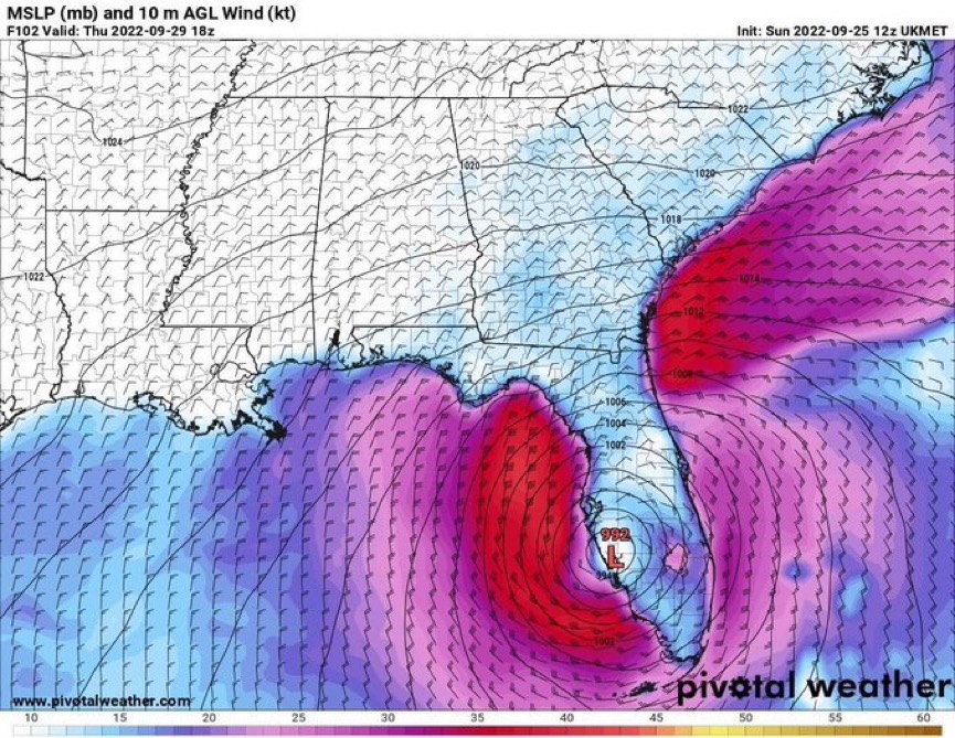
12z Euro starts NE turn from 60-66 hrs
1 likes
Hurricane Eye Experience: David 79, Irene 99, Frances 04, Jeanne 04, Wilma 05...
Hurricane Brush Experience: Andrew 92, Erin 95, Floyd 99, Matthew 16, Irma 17, Ian 22, Nicole 22…
Hurricane Brush Experience: Andrew 92, Erin 95, Floyd 99, Matthew 16, Irma 17, Ian 22, Nicole 22…
Who is online
Users browsing this forum: No registered users and 16 guests