ATL: IAN - Models
Moderator: S2k Moderators
Re: ATL: IAN - Models
My opinion models 5 days and out are just for general information and guidance. Once you get to days 4-5 then what the models produce become more relevant. Yeah the GFS has been all over the coast and the Euro has been mostly pointed at SW FL. But in the grand scheme of things it’s what have you done for me lately. Granted I have no idea where Ian will landfall, in the final analysis if it’s south of Tampa the give kudos to the Euro, but if it landfalls on the Panhandle then some credit should be given to the GFS. And if they split the difference then give both models credit, you certainly don’t want your model to be wrong 3 days out, that’s a given. My humble opinion.
Last edited by Frank P on Sat Sep 24, 2022 10:17 am, edited 1 time in total.
8 likes

Re: ATL: IAN - Models
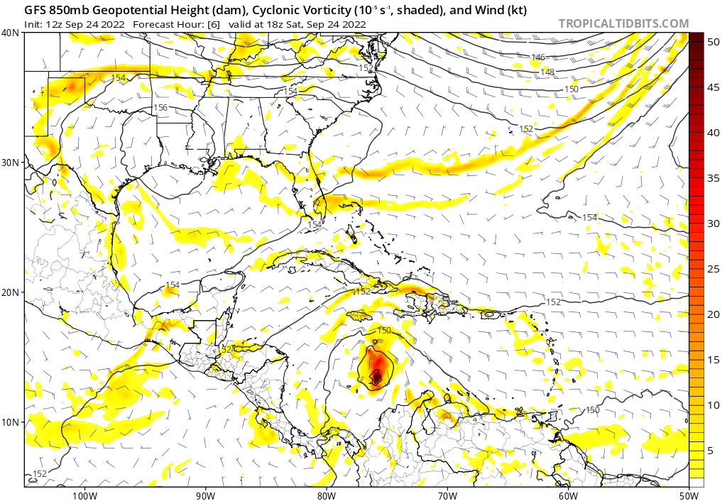
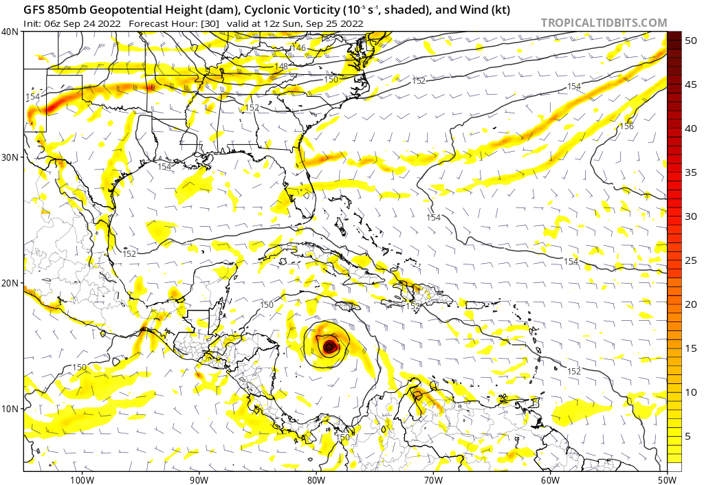
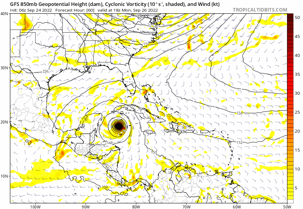
Ian's UL environment becomes the most favorable later on Sunday through midday Monday on the HWRF, but it remains decent even through Tuesday night.


Afterwards, though, the UL pattern quickly becomes more hostile and should weaken Ian. Instead of UL flow expanding away from all quadrants of the storm, it gets directed into Ian from the W or SW.


Afterwards, though, the UL pattern quickly becomes more hostile and should weaken Ian. Instead of UL flow expanding away from all quadrants of the storm, it gets directed into Ian from the W or SW.
1 likes
Irene '11 Sandy '12 Hermine '16 5/15/2018 Derecho Fay '20 Isaias '20 Elsa '21 Henri '21 Ida '21
I am only a meteorology enthusiast who knows a decent amount about tropical cyclones. Look to the professional mets, the NHC, or your local weather office for the best information.
I am only a meteorology enthusiast who knows a decent amount about tropical cyclones. Look to the professional mets, the NHC, or your local weather office for the best information.
-
toad strangler

- S2K Supporter

- Posts: 4162
- Joined: Sun Jul 28, 2013 3:09 pm
- Location: Earth
- Contact:
Re: ATL: IAN - Models
ScottNAtlanta wrote:I hear lots of talk about shear, but if this is a cat 3 or higher coming into the GOM, shear is not going to be much help. Look at Fiona which endured much higher shear than is forecast possibly for Ian almost throughout and maintained as a Cat 4. Strong storms create their own environment many times. Don't put much hope into shear causing much weakening if this is a strong cat 3 into the gulf.
Well I hear what you are saying but when you hear guys like Papin saying it you gotta listen right? It’s not hope. These guys are pros.
5 likes
-
cheezyWXguy

- Category 5

- Posts: 5537
- Joined: Mon Feb 13, 2006 12:29 am
- Location: Dallas, TX
Re: ATL: IAN - Models
aspen wrote:Ian's UL environment becomes the most favorable later on Sunday through midday Monday on the HWRF, but it remains decent even through Tuesday night.
https://i.imgur.com/dgfM3o1.png
https://i.imgur.com/mjJGJPY.png
Afterwards, though, the UL pattern quickly becomes more hostile and should weaken Ian. Instead of UL flow expanding away from all quadrants of the storm, it gets directed into Ian from the W or SW.
https://i.imgur.com/wc4dIFX.png
https://i.imgur.com/VlT4QID.png
I’ve seen a few people mention Michael (not because of strength, but more because of setup), but I don’t remember much of the details as to why it was able to strengthen so much in the shear pattern it contended with. Is this a similar setup?
1 likes
-
Jelmergraaff
- Tropical Storm

- Posts: 127
- Age: 21
- Joined: Fri Aug 27, 2021 1:00 pm
- Location: The Netherlands
Re: ATL: IAN - Models
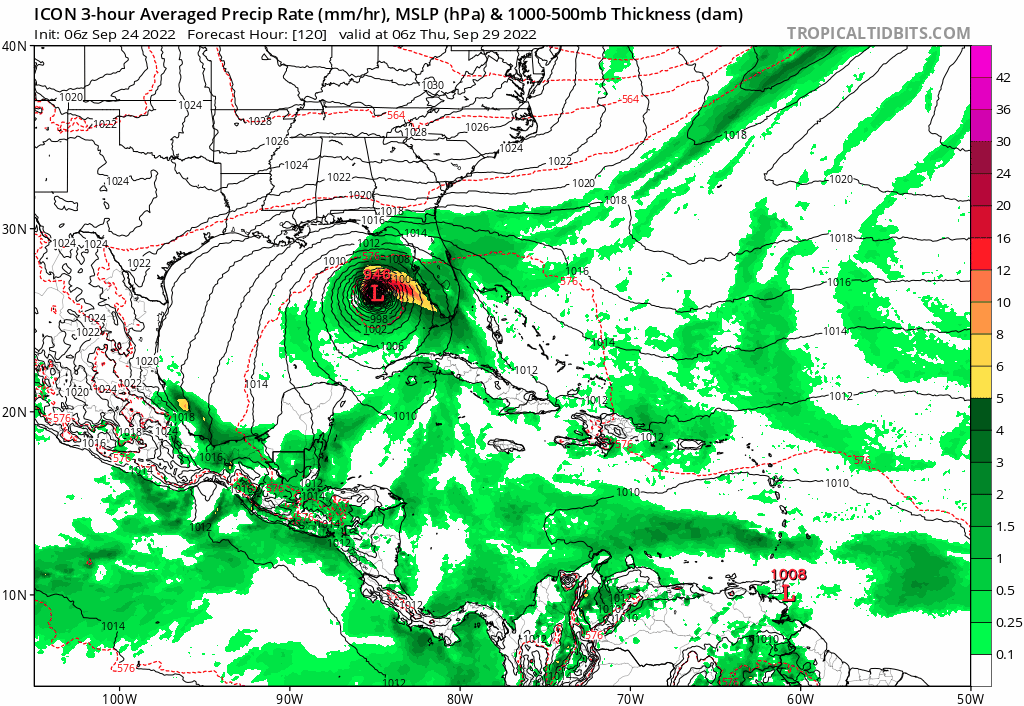
ICON (12z) quite a shift to the north compared to the 00z-run, also later and a lot stronger.
1 likes
20-year old meteorologist from The Netherlands. Interested in all fields of meteorology, including tropical systems like hurricanes.

-
gatorcane

- S2K Supporter
- Posts: 23499
- Age: 46
- Joined: Sun Mar 13, 2005 3:54 pm
- Location: Boca Raton, FL
Re: ATL: IAN - Models
Jelmergraaff wrote:ICON (12z) quite a shift to the north compared to the 00z-run, also later and a lot stronger.
Heading NE towards west coast of Florida and strong
4 likes

Re: ATL: IAN - Models
12z ICON to the east and north of its previous 06z run, a little to the left of the NHC track.

1 likes
-
ConvergenceZone
.gif)
- Category 5
- Posts: 4833
- Joined: Fri Jul 29, 2005 1:40 am
- Location: Northern California
Re: ATL: IAN - Models
Regarding the intense shear in the gulf that people are talking about, yea, they were mentioning on the weather report this morning that due to dry air and very high amounts of shear that if we get lucky, we may only have a tropical storm to deal with in the Gulf of Mexico at time of landfall, but that the NHC is going to keep the strength as it is for now.............and residents should still prepare for a hurricane just in case. Also mentioning that a major hurricane is still very possible in the Carib,
Last edited by ConvergenceZone on Sat Sep 24, 2022 10:47 am, edited 3 times in total.
1 likes
-
ScottNAtlanta

- Category 5
- Posts: 1999
- Joined: Sat May 25, 2013 3:11 pm
- Location: Atlanta, GA
Re: ATL: IAN - Models
toad strangler wrote:ScottNAtlanta wrote:I hear lots of talk about shear, but if this is a cat 3 or higher coming into the GOM, shear is not going to be much help. Look at Fiona which endured much higher shear than is forecast possibly for Ian almost throughout and maintained as a Cat 4. Strong storms create their own environment many times. Don't put much hope into shear causing much weakening if this is a strong cat 3 into the gulf.
Well I hear what you are saying but when you hear guys like Papin saying it you gotta listen right? It’s not hope. These guys are pros.
Even the pros will tell you that our forecasting ability of RI especially in this area of the Caribbean can be way under done. The pros at the NHC have also been saying that as well
1 likes
The posts in this forum are NOT official forecast and should not be used as such. They are just the opinion of the poster and may or may not be backed by sound meteorological data. They are NOT endorsed by any professional institution or storm2k.org. For official information, please refer to the NHC and NWS products.
-
Jelmergraaff
- Tropical Storm
- Posts: 127
- Age: 21
- Joined: Fri Aug 27, 2021 1:00 pm
- Location: The Netherlands
Re: ATL: IAN - Models
Could eventually be positive if it takes (a lot) longer to reach the FL-coast, so that dry-air/shear may weaken it some. On the other hand, however, not passing over Cuba would mean an even stronger system entering the GOM.
2 likes
20-year old meteorologist from The Netherlands. Interested in all fields of meteorology, including tropical systems like hurricanes.
-
FLWeatherX
- Tropical Wave

- Posts: 6
- Joined: Fri Sep 23, 2022 12:09 am
Re: ATL: IAN - Models
gatorcane wrote:Comparison of last two ICON runs. East shift:
https://i.postimg.cc/2j4jG2Mt/icon-mslp-pcpn-watl-fh114-trend.gif
https://twitter.com/wx_tiger/status/157 ... zhbPc98xZQ
Not sure but thinking East shifts might come back....
1 likes


Re: ATL: IAN - Models
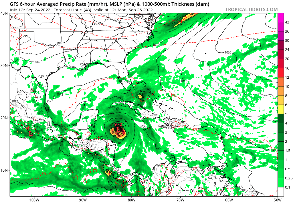
12Z GFS is trending stronger and farther south than the 6Z GFS
At 48 hours - 979 millibars down to 970 millibars
At 48 hours - 979 millibars down to 970 millibars
0 likes
-
Jelmergraaff
- Tropical Storm
- Posts: 127
- Age: 21
- Joined: Fri Aug 27, 2021 1:00 pm
- Location: The Netherlands
Re: ATL: IAN - Models
GFS (12z) will probably find the gap between the Yucatan and Cuba again. At +72h still 6 mb stronger than the 06z-run.

3 likes
20-year old meteorologist from The Netherlands. Interested in all fields of meteorology, including tropical systems like hurricanes.
-
cycloneye

- Admin

- Posts: 139141
- Age: 67
- Joined: Thu Oct 10, 2002 10:54 am
- Location: San Juan, Puerto Rico
Re: ATL: IAN - Models
Goes thru Yucatán Channel.
3 likes
Visit the Caribbean-Central America Weather Thread where you can find at first post web cams,radars
and observations from Caribbean basin members Click Here
and observations from Caribbean basin members Click Here
Who is online
Users browsing this forum: No registered users and 21 guests