EPAC: ORLENE - Remnants

Moderator: S2k Moderators

Message
Author
zeehag
Tropical Storm
Tropical Storm
Posts: 172
Age: 75
Joined: Sun Jul 17, 2011 9:49 pm
Location: mazatlan,sinaloa, mexico, fixing patricia's mess.
Contact:

Re: EPAC: ORLENE - Tropical Storm

#41 Postby zeehag » Fri Sep 30, 2022 5:22 pm

Astromanía wrote:Mazatlan may get hit

may??? looks pretty definite so far to me.. eeps and egads.. and here we go again..
0 likes   
life is an adventure meant to be LIVED!!!

http://www.sksolitarybird.org

User avatar
cycloneye
Admin
Admin
Posts: 139025
Age: 67
Joined: Thu Oct 10, 2002 10:54 am
Location: San Juan, Puerto Rico

Re: EPAC: ORLENE - Tropical Storm

#42 Postby cycloneye » Fri Sep 30, 2022 7:27 pm

BULLETIN
Tropical Storm Orlene Intermediate Advisory Number 8A
NWS National Hurricane Center Miami FL EP162022
600 PM MDT Fri Sep 30 2022

...TINY ORLENE HEADING NORTH-NORTHWESTWARD...
...WATCHES IN EFFECT FOR LAS ISLAS MARIAS AND A PORTION OF MAINLAND
MEXICO...


SUMMARY OF 600 PM MDT...0000 UTC...INFORMATION
----------------------------------------------
LOCATION...16.8N 107.2W
ABOUT 265 MI...425 KM SSW OF CABO CORRIENTES MEXICO
ABOUT 325 MI...525 KM S OF LAS ISLAS MARIAS MEXICO
MAXIMUM SUSTAINED WINDS...65 MPH...100 KM/H
PRESENT MOVEMENT...NNW OR 335 DEGREES AT 5 MPH...7 KM/H
MINIMUM CENTRAL PRESSURE...994 MB...29.36 INCHES
0 likes   
Visit the Caribbean-Central America Weather Thread where you can find at first post web cams,radars
and observations from Caribbean basin members Click Here

User avatar
Yellow Evan
Professional-Met
Professional-Met
Posts: 15951
Age: 25
Joined: Fri Jul 15, 2011 12:48 pm
Location: Henderson, Nevada/Honolulu, HI
Contact:

Re: EPAC: ORLENE - Tropical Storm

#43 Postby Yellow Evan » Fri Sep 30, 2022 7:42 pm

TXPZ28 KNES 010018
TCSENP

A. 16E (ORLENE)

B. 30/2330Z

C. 16.5N

D. 107.4W

E. THREE/GOES-W

F. T3.0/3.0

G. IR/EIR/VIS/SSMIS

H. REMARKS...LLCC THAT IS LOCATED UNDER A WELL-DEFINED CDO WITH A
DIAMETER >1.25 DEG RESULTS IN A DT OF 3.0. MET AND PT=3.5. 2241Z SSMIS
PASS GAVE GOOD FIX FOR LLCC. FT BASED ON DT.

I. ADDL POSITIONS

30/2241Z 16.4N 107.4W SSMIS


...KONON
0 likes   

Sciencerocks
Category 5
Category 5
Posts: 7282
Age: 38
Joined: Thu Jul 06, 2017 1:51 am

Re: EPAC: ORLENE - Tropical Storm

#44 Postby Sciencerocks » Fri Sep 30, 2022 8:57 pm

Image
0 likes   

User avatar
Yellow Evan
Professional-Met
Professional-Met
Posts: 15951
Age: 25
Joined: Fri Jul 15, 2011 12:48 pm
Location: Henderson, Nevada/Honolulu, HI
Contact:

Re: EPAC: ORLENE - Tropical Storm

#45 Postby Yellow Evan » Fri Sep 30, 2022 8:57 pm

Image

Beautiful outflow (you can tell it’s being ventilated by a ULAC) with a small and symmetrical core.
3 likes   

User avatar
cycloneye
Admin
Admin
Posts: 139025
Age: 67
Joined: Thu Oct 10, 2002 10:54 am
Location: San Juan, Puerto Rico

Re: EPAC: ORLENE - Tropical Storm

#46 Postby cycloneye » Fri Sep 30, 2022 10:11 pm

BULLETIN
Tropical Storm Orlene Advisory Number 9
NWS National Hurricane Center Miami FL EP162022
900 PM MDT Fri Sep 30 2022

...ORLENE MOVING NORTHWARD...
...TROPICAL STORM WARNING IN EFFECT FOR A PORTION OF MAINLAND
MEXICO...


SUMMARY OF 900 PM MDT...0300 UTC...INFORMATION
----------------------------------------------
LOCATION...17.0N 107.2W
ABOUT 255 MI...410 KM SSW OF CABO CORRIENTES MEXICO
ABOUT 315 MI...505 KM S OF LAS ISLAS MARIAS MEXICO
MAXIMUM SUSTAINED WINDS...65 MPH...100 KM/H
PRESENT MOVEMENT...N OR 360 DEGREES AT 5 MPH...7 KM/H
MINIMUM CENTRAL PRESSURE...994 MB...29.36 INCHES


WATCHES AND WARNINGS
--------------------
CHANGES WITH THIS ADVISORY:

The Government of Mexico has issued a Tropical Storm Warning for
the coast of mainland Mexico from Playa Perula to San Blas, and a
Hurricane Watch from San Blas to Bahia Tempehuaya.


Tropical Storm Orlene Discussion Number 9
NWS National Hurricane Center Miami FL EP162022
900 PM MDT Fri Sep 30 2022

Orlene had another burst of deep convection in the past few hours.
Earlier microwave imagery from SSMI/S still showed a small inner
core with a curved band to the south. Subjective and objective
satellite Dvorak classifications continue to range between 45 to 65
kt. Therefore, the initial intensity remains at 55 kt to represent
a blend of these estimates.

The storm is embedded in an environment conducive for further
intensification. Global models suggest the vertical wind shear is
low and the surrounding mid-level humidities are relatively moist
and should remain this way for the next day or so. These
conditions, combined with warm sea surface temperatures, create the
potential for steady to rapid intensification. In fact,
statistical guidance indicates there is a higher than average
probability of rapid intensification in the upcoming 24 hours. The
official forecast still shows Orlene steadily strengthening to peak
near 85 kt in 36 hours and little changes have been made since the
previous advisory. Beyond this period, the vertical wind shear is
expected to increase and induce weakening until landfall. It should
be noted that the NHC intensity forecast is on the high end of the
guidance to account for the possibility of rapid intensification.

The cyclone is moving along the periphery of a ridge over central
Mexico. In the next day, Orlene is expected to turn
north-northeastward in the flow between the ridge and an upper-level
trough over northwestern Mexico and the northern Baja California
peninsula and continue this trajectory until landfall. The latest
NHC track prediction is slightly east of the previous track forecast
and a little faster than the consensus model aids. This forecast
favors the GFS track solution over the ECMWF.

Based on the the forecast track and wind radii, the Government of
Mexico has issued a Tropical Storm Warning and a Hurricane Watch for
portions of mainland Mexico. Additional watches and warnings will
likely be required in the coming day.

Key Messages:

1. Hurricane conditions are possible in the Islas Marias on Sunday,
where a hurricane watch has been issued. Tropical storm conditions
are expected within the tropical storm warning area from Playa
Perula to San Blas within the next 36 h. Tropical storm conditions
are possible over other portions of southwestern and west-central
Mexico in the tropical storm watch area.

2. Heavy rainfall from Orlene is expected to lead to flash flooding,
as well as possible landslides in areas of mountainous terrain of
Southwest Mexico into Monday afternoon.


FORECAST POSITIONS AND MAX WINDS

INIT 01/0300Z 17.0N 107.2W 55 KT 65 MPH
12H 01/1200Z 17.6N 107.2W 65 KT 75 MPH
24H 02/0000Z 18.6N 107.1W 75 KT 85 MPH
36H 02/1200Z 19.8N 106.8W 85 KT 100 MPH
48H 03/0000Z 21.1N 106.5W 75 KT 85 MPH
60H 03/1200Z 22.4N 106.3W 65 KT 75 MPH
72H 04/0000Z 23.6N 106.0W 45 KT 50 MPH...INLAND
96H 05/0000Z 25.5N 105.5W 25 KT 30 MPH...INLAND
120H 06/0000Z...DISSIPATED

$$
Forecaster Bucci
0 likes   
Visit the Caribbean-Central America Weather Thread where you can find at first post web cams,radars
and observations from Caribbean basin members Click Here

User avatar
Yellow Evan
Professional-Met
Professional-Met
Posts: 15951
Age: 25
Joined: Fri Jul 15, 2011 12:48 pm
Location: Henderson, Nevada/Honolulu, HI
Contact:

Re: EPAC: ORLENE - Tropical Storm

#47 Postby Yellow Evan » Sat Oct 01, 2022 1:49 am

TXPZ28 KNES 010548
TCSENP

A. 16E (ORLENE)

B. 01/0530Z

C. 17.1N

D. 107.1W

E. THREE/GOES-W

F. T3.5/3.5

G. IR/EIR/SWIR

H. REMARKS...8/10 BANDING RESULTS IN A DT OF 3.5. MET IS 3.0 BASED ON
GRADUAL 24-HOUR DEVELOPMENT. PT IS 3.5. THE FT IS BASED ON THE PT DUE
TO AMBIGUITY IN THE BANDING AND UNCERTAINTY IN CENTER LOCATION.

I. ADDL POSITIONS

NIL


...CLARK
0 likes   

User avatar
cycloneye
Admin
Admin
Posts: 139025
Age: 67
Joined: Thu Oct 10, 2002 10:54 am
Location: San Juan, Puerto Rico

Re: EPAC: ORLENE - Tropical Storm

#48 Postby cycloneye » Sat Oct 01, 2022 3:38 am

BULLETIN
Tropical Storm Orlene Advisory Number 10
NWS National Hurricane Center Miami FL EP162022
300 AM MDT Sat Oct 01 2022

...ORLENE INCHING ITS WAY NORTHWARD...
...EXPECTED TO PASS JUST WEST OF JALISCO, MEXICO LATER THIS
WEEKEND...


SUMMARY OF 300 AM MDT...0900 UTC...INFORMATION
----------------------------------------------
LOCATION...17.2N 107.0W
ABOUT 235 MI...380 KM SSW OF CABO CORRIENTES MEXICO
ABOUT 300 MI...480 KM S OF LAS ISLAS MARIAS MEXICO
MAXIMUM SUSTAINED WINDS...65 MPH...100 KM/H
PRESENT MOVEMENT...N OR 360 DEGREES AT 5 MPH...7 KM/H
MINIMUM CENTRAL PRESSURE...994 MB...29.36 INCHES


Tropical Storm Orlene Discussion Number 10
NWS National Hurricane Center Miami FL EP162022
300 AM MDT Sat Oct 01 2022

Orlene has changed little in organization overnight. Recent
microwave satellite imagery revealed Orlene is trying to maintain
an inner core despite some dry air attempting to wrap in from its
east. Scatterometer data indicated that the low-level center was
slightly to the southeast of what was previously estimated. These
data suggest that the cyclone may be feeling the affects of some
southeasterly shear, possibly caused by flow around the ridge to its
east. The initial intensity remains unchanged at 55 kt and is based
off a blend of the latest Dvorak intensity estimates from SAB and
the UW-CIMSS ADT.

The storm has about 36 h left to take advantage of the relatively
low vertical wind shear and moist thermodynamic environment. After
36 h, increasing southwesterly shear should cause Orlene to steadily
weaken before reaching the coast of mainland Mexico early next week.
The cyclone is then expected to dissipate shortly after moving
inland. The overall model guidance continues to back off on the
peak intensity of Orlene, likely due to the fact the cyclone has not
been able to strengthen as quickly as expected over the past day or
so. The NHC intensity forecast is slightly lower than the previous
one, and is on the high end of the guidance.

Orlene is moving slowly northward, at only 4 kt, to the west of a
mid-level ridge. By tonight, the cyclone should turn
north-northeastward in the flow between the ridge and an upper-level
trough over northwestern Mexico and the northern Baja California
peninsula. This north-northeastward motion is forecast to continue
until Orlene dissipates over mainland Mexico. The latest NHC track
forecast was nudged just east of the previous one, mainly due to the
slight southeastward adjustment of the initial position.

Based on the the forecast track, intensity, and wind radii,
Hurricane or Tropical Storm Warnings will likely be required for
portions of the Hurricane Watch area later today.


Key Messages:

1. Hurricane conditions are possible in the Islas Marias Sunday
night, with tropical storm conditions beginning late Sunday.
Tropical storm conditions are expected within the tropical storm
warning area along the west-central coast of Mexico on Sunday.
Tropical storm conditions are possible over other portions of
southwestern and west-central Mexico in the tropical storm watch
area tonight or Sunday.

2. Heavy rainfall from Orlene is expected to lead to flash flooding,
as well as possible landslides in areas of rugged terrain of
Southwest Mexico into Monday evening.


FORECAST POSITIONS AND MAX WINDS

INIT 01/0900Z 17.2N 107.0W 55 KT 65 MPH
12H 01/1800Z 17.9N 106.9W 65 KT 75 MPH
24H 02/0600Z 18.9N 106.8W 75 KT 85 MPH
36H 02/1800Z 20.0N 106.5W 80 KT 90 MPH
48H 03/0600Z 21.2N 106.2W 70 KT 80 MPH
60H 03/1800Z 22.5N 105.9W 60 KT 70 MPH
72H 04/0600Z 23.7N 105.6W 30 KT 35 MPH...INLAND
96H 05/0600Z...DISSIPATED

$$
Forecaster Latto
0 likes   
Visit the Caribbean-Central America Weather Thread where you can find at first post web cams,radars
and observations from Caribbean basin members Click Here

Sciencerocks
Category 5
Category 5
Posts: 7282
Age: 38
Joined: Thu Jul 06, 2017 1:51 am

Re: EPAC: ORLENE - Tropical Storm

#49 Postby Sciencerocks » Sat Oct 01, 2022 9:49 am

Image
0 likes   

User avatar
Teban54
Category 5
Category 5
Posts: 1952
Joined: Sat May 19, 2018 1:19 pm

Re: EPAC: ORLENE - Tropical Storm

#50 Postby Teban54 » Sat Oct 01, 2022 9:56 am

From IR alone, does look like it's building an eyewall now.
0 likes   

User avatar
Iceresistance
Category 5
Category 5
Posts: 8910
Age: 20
Joined: Sat Oct 10, 2020 9:45 am
Location: Tecumseh, OK/Norman, OK

Re: EPAC: ORLENE - Hurricane

#51 Postby Iceresistance » Sat Oct 01, 2022 9:57 am

Now a hurricane

...ORLENE BECOMES A HURRICANE... ...HURRICANE WARNINGS ISSUED FOR LAS ISLAS MARIAS...

9:00 AM MDT Sat Oct 1
Location: 17.6°N 107.0°W
Moving: N at 5 mph
Min pressure: 989 mb
Max sustained: 75 mph


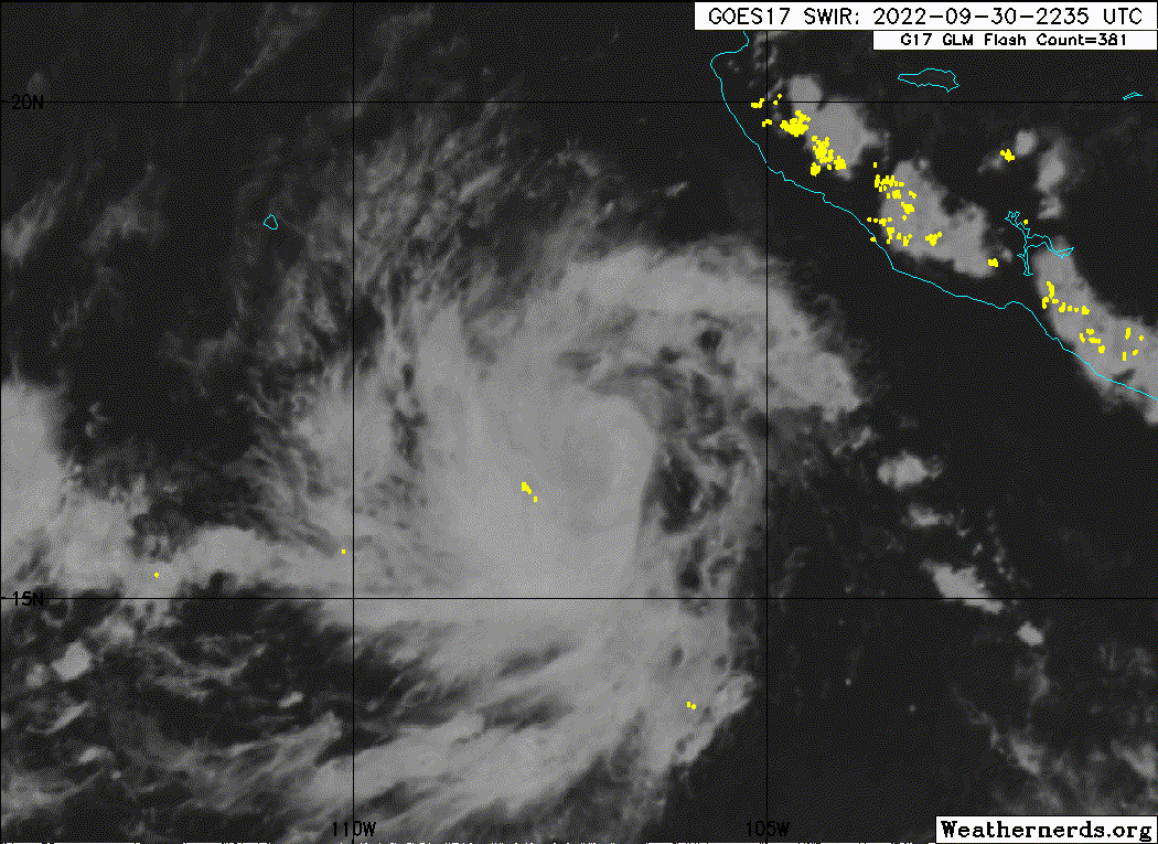
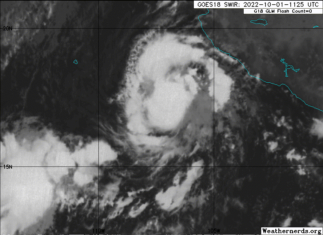
Conventional satellite imagery and a recent SSM/IS overpass indicate
that Orlene is becoming better organized, with the central
convection becoming more symmetric and starting to develop into an
eyewall. There have also been hints of an eye on infrared imagery.
Satellite intensity estimates at 12Z were in the 55-65 kt range, and
since that time estimates from the CIMSS Advanced Dvorak Technique
have increased to over 70 kt. Based on this data, Orlene is
upgraded to a hurricane with an initial intensity of 65 kt. An Air
Force Reserve Hurricane Hunter aircraft is scheduled to investigate
Orlene later today.

Orlene should be in a moist and light-shear environment for about
the next 24 h, and with the increased core organization steady to
rapid intensification is expected. The new intensity forecast
calls for a peak intensity of 80 kt in about 24 h. After that,
strong southwesterly shear should cause steady to rapid weakening
until landfall in Mexico. This should be followed by dissipation
over the mountains of northwestern Mexico between 72-96 h. While
it cannot be ruled out that Orlene could reach mainland Mexico as a
hurricane, the chances of that have decreased since yesterday based
on the current trends and guidance. The new intensity forecast has
some adjustments from the previous forecast and lies near or at the
upper edge of the intensity guidance.

Orlene continues moving slowly northward at 360/4 kt, to the west of
a mid-level ridge. After about 12 h, the cyclone should turn
north-northeastward in the flow between this ridge and an
upper-level trough seen in water vapor imagery over northwestern
Mexico and the northern Baja California peninsula. This
north-northeastward motion is forecast to continue until Orlene
dissipates over mainland Mexico. The track guidance is fairly
tightly clustered around this track, although the GFS is a bit to
the right of the other models. The new forecast track is close to
the various consensus models and is just a little to the left of the
previous forecast.

Based on the the forecast track, intensity, and wind radii, a
Hurricane Warning has been issued for Las Islas Marias.


Key Messages:

1. Hurricane conditions are expected in the Islas Marias Sunday
night, with tropical storm conditions beginning late Sunday.
Hurricane conditions are possible over portions of the west-central
mainland Mexico starting on Monday. Tropical storm conditions are
expected within the tropical storm warning area along the
west-central coast of Mexico on Sunday. Tropical storm conditions
are possible over other portions of southwestern and west-central
Mexico in the tropical storm watch area tonight or Sunday.

2. Heavy rainfall from Orlene is expected to lead to flash flooding,
as well as possible landslides in areas of rugged terrain in
Southwest Mexico through Monday evening.


FORECAST POSITIONS AND MAX WINDS

INIT 01/1500Z 17.6N 107.0W 65 KT 75 MPH
12H 02/0000Z 18.3N 107.0W 70 KT 80 MPH
24H 02/1200Z 19.2N 106.8W 80 KT 90 MPH
36H 03/0000Z 20.5N 106.6W 75 KT 85 MPH
48H 03/1200Z 21.6N 106.3W 65 KT 75 MPH
60H 04/0000Z 22.8N 105.8W 55 KT 65 MPH...INLAND
72H 04/1200Z 24.0N 105.4W 25 KT 30 MPH...INLAND
96H 05/1200Z...DISSIPATED
1 likes   
Bill 2015 & Beta 2020

Winter 2020-2021 :cold:

All observations are in Tecumseh, OK unless otherwise noted.

Winter posts are focused mainly for Oklahoma & Texas.

Take any of my forecasts with a grain of salt, refer to the NWS, SPC, and NHC for official information

Never say Never with weather! Because ANYTHING is possible!

zeehag
Tropical Storm
Tropical Storm
Posts: 172
Age: 75
Joined: Sun Jul 17, 2011 9:49 pm
Location: mazatlan,sinaloa, mexico, fixing patricia's mess.
Contact:

Re: EPAC: ORLENE - Tropical Storm

#52 Postby zeehag » Sat Oct 01, 2022 10:01 am

looks to be tracking south and east a little ... the current track past mazatlan looks reminiscent of willa track to escuinapa... mazatlan is happy but escuinapa is not .
0 likes   
life is an adventure meant to be LIVED!!!

http://www.sksolitarybird.org

User avatar
aspen
Category 5
Category 5
Posts: 8056
Joined: Sat Oct 12, 2019 7:10 pm
Location: Connecticut, USA

Re: EPAC: ORLENE - Hurricane

#53 Postby aspen » Sat Oct 01, 2022 1:11 pm

Recon’s communications went out over an hour ago, because of course they just had to fail on approach to Orlene.
0 likes   
Irene '11 Sandy '12 Hermine '16 5/15/2018 Derecho Fay '20 Isaias '20 Elsa '21 Henri '21 Ida '21

I am only a meteorology enthusiast who knows a decent amount about tropical cyclones. Look to the professional mets, the NHC, or your local weather office for the best information.

User avatar
aspen
Category 5
Category 5
Posts: 8056
Joined: Sat Oct 12, 2019 7:10 pm
Location: Connecticut, USA

Re: EPAC: ORLENE - Hurricane

#54 Postby aspen » Sat Oct 01, 2022 1:49 pm

AF data is finally coming through. Nearly all of the first eyewall pass is missing, but a 979/5 eye drop came through and shows that Orlene is still intensifying.
0 likes   
Irene '11 Sandy '12 Hermine '16 5/15/2018 Derecho Fay '20 Isaias '20 Elsa '21 Henri '21 Ida '21

I am only a meteorology enthusiast who knows a decent amount about tropical cyclones. Look to the professional mets, the NHC, or your local weather office for the best information.

User avatar
Yellow Evan
Professional-Met
Professional-Met
Posts: 15951
Age: 25
Joined: Fri Jul 15, 2011 12:48 pm
Location: Henderson, Nevada/Honolulu, HI
Contact:

Re: EPAC: ORLENE - Hurricane

#55 Postby Yellow Evan » Sat Oct 01, 2022 2:27 pm

They’ll probably find stronger winds on the NE.
0 likes   

User avatar
Teban54
Category 5
Category 5
Posts: 1952
Joined: Sat May 19, 2018 1:19 pm

Re: EPAC: ORLENE - Hurricane

#56 Postby Teban54 » Sat Oct 01, 2022 2:41 pm

Yellow Evan wrote:They’ll probably find stronger winds on the NE.

NE quad: 80 kt FL, 69 kt SFMR.
0 likes   

sikkar
Category 1
Category 1
Posts: 323
Joined: Sun Aug 26, 2012 1:44 am
Location: Florida

Re: EPAC: ORLENE - Hurricane

#57 Postby sikkar » Sat Oct 01, 2022 3:23 pm

Hurricane Willa passed through the Islas Marias on October 23, 2018. The National Hurricane Center reported at 9 AM MDT "Aircraft finds the core of Willa passing over Las Islas Marias Mexico".[6] A subsequent report from the NHC stated that "Life-threatening storm surge is occurring along the coasts of the Isla Marias'.[7] The NHC also reported that "An automated observing site on Las Islas Marias recently reported a sustained wind of 88 mph (142 km/h) with a gust to 112mph (180 km/h)"

Any one has access to that station?
0 likes   
Personal Forecast Disclaimer:
The posts in this forum are NOT official forecast and should not be used as such. They are just the opinion of the poster and may or may not be backed by sound meteorological data. For official information, please refer to the NHC and NWS products.

sikkar
Category 1
Category 1
Posts: 323
Joined: Sun Aug 26, 2012 1:44 am
Location: Florida

Re: EPAC: ORLENE - Hurricane

#58 Postby sikkar » Sat Oct 01, 2022 3:24 pm

Looks like center will pass on top of it..
0 likes   
Personal Forecast Disclaimer:
The posts in this forum are NOT official forecast and should not be used as such. They are just the opinion of the poster and may or may not be backed by sound meteorological data. For official information, please refer to the NHC and NWS products.

Netzero9455
Tropical Low
Tropical Low
Posts: 19
Joined: Sun Oct 23, 2016 6:23 pm

Re: EPAC: ORLENE - Hurricane

#59 Postby Netzero9455 » Sat Oct 01, 2022 3:44 pm

sikkar wrote:Hurricane Willa passed through the Islas Marias on October 23, 2018. The National Hurricane Center reported at 9 AM MDT "Aircraft finds the core of Willa passing over Las Islas Marias Mexico".[6] A subsequent report from the NHC stated that "Life-threatening storm surge is occurring along the coasts of the Isla Marias'.[7] The NHC also reported that "An automated observing site on Las Islas Marias recently reported a sustained wind of 88 mph (142 km/h) with a gust to 112mph (180 km/h)"

Any one has access to that station?


https://meteorologia.semar.gob.mx/dirme ... arias.html

This should work, don't know how accurate it is of course but it updates regularly and has pressure, winds, direction and gusts.
0 likes   

User avatar
cycloneye
Admin
Admin
Posts: 139025
Age: 67
Joined: Thu Oct 10, 2002 10:54 am
Location: San Juan, Puerto Rico

Re: EPAC: ORLENE - Hurricane

#60 Postby cycloneye » Sat Oct 01, 2022 3:47 pm

BULLETIN
Hurricane Orlene Advisory Number 12
NWS National Hurricane Center Miami FL EP162022
300 PM MDT Sat Oct 01 2022

...HURRICANE HUNTER AIRCRAFT REPORTS THAT ORLENE IS STRENGTHENING...


SUMMARY OF 300 PM MDT...2100 UTC...INFORMATION
----------------------------------------------
LOCATION...17.9N 107.1W
ABOUT 195 MI...315 KM SSW OF CABO CORRIENTES MEXICO
ABOUT 255 MI...405 KM S OF LAS ISLAS MARIAS MEXICO
MAXIMUM SUSTAINED WINDS...80 MPH...130 KM/H
PRESENT MOVEMENT...N OR 360 DEGREES AT 5 MPH...7 KM/H
MINIMUM CENTRAL PRESSURE...979 MB...28.91 INCHES


Hurricane Orlene Discussion Number 12
NWS National Hurricane Center Miami FL EP162022
300 PM MDT Sat Oct 01 2022

Orlene has strengthened some since the last advisory. An Air Force
Reserve Hurricane Hunter aircraft reported 700-mb flight-level
winds of 80 kt in the the northeastern eyewall, and reliable-
looking surface wind estimates of 69-72 kt from the SFMR. The
central pressure inside the 16-n mi wide eye was 979 mb. Based on
these data, the initial intensity is increased to a possibly
conservative 70 kt. Data from the aircraft and a recent
scatterometer overpass show that Orlene remains a small tropical
cyclone.

Orlene should remain in a generally moist and light-shear
environment for about the next 18-24 h, and continued steady
intensification is expected during that time. The new intensity
forecast now calls for a peak intensity of 85 kt in about 24 h, a
slightly higher intensity than the previous forecast. After that,
strong southwesterly shear should cause steady to rapid weakening
until landfall in Mexico. This should be followed by dissipation
over the mountains of northwestern Mexico between 72-96 h. As
mentioned previously, while it cannot be ruled out that Orlene
could reach mainland Mexico as a hurricane, the chances of that
are decreasing based on the guidance and the forecast shear. The
new intensity forecast again lies near or at the upper edge of the
intensity guidance.

Orlene is generally moving slowly northward, 360/4 kt, to the
west of a mid-level ridge. After about 12 h, the cyclone should turn
north-northeastward in the flow between this ridge and an upper-
level trough seen in water vapor imagery over northwestern Mexico
and the northern Baja California peninsula. This motion is forecast
to continue until Orlene dissipates over mainland Mexico. The
track guidance is fairly tightly clustered together, although the
GFS remains a bit to the right of the other models after 24 h. The
guidance envelope has shifted a little westward since the previous
advisory, and based on this the new forecast track is again nudged a
little to the west. However, the new track lies a little east of
the various consensus models, between them and the GFS.


Key Messages:

1. Hurricane conditions are expected in the Islas Marias Sunday
night, with tropical storm conditions beginning late Sunday.
Hurricane conditions are possible over portions of west-central
mainland Mexico starting on Monday. Tropical storm conditions are
expected within the tropical storm warning area along the
west-central coast of Mexico on Sunday. Tropical storm conditions
are possible over other portions of southwestern and west-central
Mexico in the tropical storm watch area tonight or Sunday.

2. Heavy rainfall from Orlene is expected to lead to flash flooding,
as well as possible landslides in areas of rugged terrain of
southwest Mexico into Monday evening.


FORECAST POSITIONS AND MAX WINDS

INIT 01/2100Z 17.9N 107.1W 70 KT 80 MPH
12H 02/0600Z 18.6N 107.0W 80 KT 90 MPH
24H 02/1800Z 19.7N 106.8W 85 KT 100 MPH
36H 03/0600Z 20.9N 106.6W 75 KT 85 MPH
48H 03/1800Z 22.1N 106.2W 65 KT 75 MPH
60H 04/0600Z 23.1N 105.8W 45 KT 50 MPH...INLAND
72H 04/1800Z 24.1N 105.2W 25 KT 30 MPH...INLAND
96H 05/1800Z...DISSIPATED

$$
Forecaster Beven
0 likes   
Visit the Caribbean-Central America Weather Thread where you can find at first post web cams,radars
and observations from Caribbean basin members Click Here


Return to “2022”

Who is online

Users browsing this forum: No registered users and 19 guests