EPAC: JULIA - Remnants - Discussion

Moderator: S2k Moderators

Message
Author
User avatar
cycloneye
Admin
Admin
Posts: 139059
Age: 67
Joined: Thu Oct 10, 2002 10:54 am
Location: San Juan, Puerto Rico

Re: ATL: INVEST 91L - Discussion

#41 Postby cycloneye » Sun Oct 02, 2022 7:49 pm

AL, 91, 2022100300, , BEST, 0, 97N, 490W, 25, 1012, DB


https://ftp.nhc.noaa.gov/atcf/btk/bal912022.dat
0 likes   
Visit the Caribbean-Central America Weather Thread where you can find at first post web cams,radars
and observations from Caribbean basin members Click Here

zhukm29
Tropical Storm
Tropical Storm
Posts: 219
Joined: Tue Aug 28, 2018 2:37 pm

Re: ATL: INVEST 91L - Discussion

#42 Postby zhukm29 » Sun Oct 02, 2022 8:17 pm

ASCAT doing what ASCAT does best :lol: Probably the cleanest miss I've seen this year, considering how large the system is!

Image
12 likes   

User avatar
ConvergenceZone
Category 5
Category 5
Posts: 4833
Joined: Fri Jul 29, 2005 1:40 am
Location: Northern California

Re: ATL: INVEST 91L - Discussion

#43 Postby ConvergenceZone » Sun Oct 02, 2022 8:17 pm

kevin wrote:Another Caribbean cruiser, here we go again. As per tradition with these sort of invests on storm2k, here's my post saying 'this is gonna be a long thread'.


It will only be a long thread if it ends up being a USA threat, otherwise, probably a fairly short thread..........Not to mention when you have such a monster that Ian was, it takes alot out of people, so there's that factor as well.......
10 likes   

User avatar
Nimbus
Category 5
Category 5
Posts: 4928
Joined: Mon Jul 19, 2004 10:54 am

Re: ATL: INVEST 91L - Discussion

#44 Postby Nimbus » Sun Oct 02, 2022 8:43 pm

The ULL to the systems NW may shred it so we have just a short term threat.
Models don't seem to agree on that though and they should know.
0 likes   

User avatar
NotSparta
Professional-Met
Professional-Met
Posts: 1647
Age: 22
Joined: Fri Aug 18, 2017 8:24 am
Location: Naples, FL
Contact:

Re: ATL: INVEST 91L - Discussion

#45 Postby NotSparta » Sun Oct 02, 2022 8:47 pm

WiscoWx02 wrote:
NotSparta wrote:
Category5Kaiju wrote:
It really has been a while since we had that kind of system before (last real one was Felix back in 2007). Who knows what this thing will do...


This one won't be that kind either, would develop/strengthen too late


Do you think this wave has much of a chance at all? Hardly any model support but that upper level environment looks pretty favorable.


Probably has a decent chance. Strong wave moving into the Caribbean in October, and eventually finding favorable conditions there? Pretty common way to get development. Meteorology > modelology. Not to say it can't not develop, but you shouldn't throw out the potential of development just because models aren't enthused
9 likes   
This post was probably an opinion of mine, and in no way is official. Please refer to http://www.hurricanes.gov for official tropical analysis and advisories.

My website, with lots of tropical wx graphics, including satellite and recon: http://cyclonicwx.com

Sailingtime
Tropical Low
Tropical Low
Posts: 28
Joined: Thu Aug 29, 2019 7:02 pm

Re: ATL: INVEST 91L - Discussion

#46 Postby Sailingtime » Sun Oct 02, 2022 9:07 pm

ConvergenceZone wrote:
kevin wrote:Another Caribbean cruiser, here we go again. As per tradition with these sort of invests on storm2k, here's my post saying 'this is gonna be a long thread'.


It will only be a long thread if it ends up being a USA threat, otherwise, probably a fairly short thread..........Not to mention when you have such a monster that Ian was, it takes alot out of people, so there's that factor as well.......


I'm in central Florida and came out pretty much OK with Ian. That said, I'm drained from both tracking the storm, preparing for the storm, going through the storm and cleaning up after the storm. Like most on here, I enjoy keeping tabs and tracking the tropics but Ian when it comes knocking on your neighborhood it's an entirely different experience. Mark me down as hoping for a peaceful October and November.
14 likes   

User avatar
tropicwatch
Category 5
Category 5
Posts: 3205
Age: 60
Joined: Sat Jun 02, 2007 10:01 am
Location: Panama City Florida
Contact:

Re: ATL: INVEST 91L - Discussion

#47 Postby tropicwatch » Sun Oct 02, 2022 9:10 pm

Currently the ULL is probably helping 91L's outflow.

Image
6 likes   
Tropicwatch


Agnes 72', Eloise 75, Elena 85', Kate 85', Charley 86', Florence 88', Beryl 94', Dean 95', Erin 95', Opal 95', Earl 98', Georges 98', Ivan 2004', Arlene 2005', Dennis 2005', Ida 2009' Debby 2012' Irma 2017' Michael 2018'

User avatar
Category5Kaiju
Category 5
Category 5
Posts: 3355
Age: 22
Joined: Thu Dec 24, 2020 12:45 pm
Location: Seattle

Re: ATL: INVEST 91L - Discussion

#48 Postby Category5Kaiju » Sun Oct 02, 2022 9:25 pm

NotSparta wrote:
WiscoWx02 wrote:
NotSparta wrote:
This one won't be that kind either, would develop/strengthen too late


Do you think this wave has much of a chance at all? Hardly any model support but that upper level environment looks pretty favorable.


Probably has a decent chance. Strong wave moving into the Caribbean in October, and eventually finding favorable conditions there? Pretty common way to get development. Meteorology > modelology. Not to say it can't not develop, but you shouldn't throw out the potential of development just because models aren't enthused


Not to mention for some reason, seems like this year models aren't always very reliable long-range (as we saw with systems like Fiona), they're mainly latching onto development in the mid-range instead
5 likes   
Unless explicitly stated, all information covered in my posts is based on my opinions and observations. Please refer to a professional meteorologist or an accredited weather research agency otherwise, especially if serious decisions must be made in the event of a potentially life-threatening tropical storm or hurricane.

User avatar
AnnularCane
S2K Supporter
S2K Supporter
Posts: 2634
Joined: Thu Jun 08, 2006 9:18 am
Location: Wytheville, VA

Re: ATL: INVEST 91L - Discussion

#49 Postby AnnularCane » Sun Oct 02, 2022 9:55 pm

zhukm29 wrote:ASCAT doing what ASCAT does best :lol: Probably the cleanest miss I've seen this year, considering how large the system is!

https://i.ibb.co/0cDfVmL/91-L-ASCAT.png


Oh come on, that had to be deliberate. :roflmao:
4 likes   
"But it never rained rain. It never snowed snow. And it never blew just wind. It rained things like soup and juice. It snowed mashed potatoes and green peas. And sometimes the wind blew in storms of hamburgers." -- Judi Barrett, Cloudy with a Chance of Meatballs

zhukm29
Tropical Storm
Tropical Storm
Posts: 219
Joined: Tue Aug 28, 2018 2:37 pm

Re: ATL: INVEST 91L - Discussion

#50 Postby zhukm29 » Sun Oct 02, 2022 10:23 pm

AnnularCane wrote:
zhukm29 wrote:ASCAT doing what ASCAT does best :lol: Probably the cleanest miss I've seen this year, considering how large the system is!

https://i.ibb.co/0cDfVmL/91-L-ASCAT.png


Oh come on, that had to be deliberate. :roflmao:


Well, luckily we have two scatterometers up there, so if one missed, then surely the other one wouldn't miss as well... especially given how much everyone is anticipating ASCAT for this system...

Even if we don't get it head on, we could at least hope for a half pass—

Image

:roflmao:
8 likes   

Sciencerocks
Category 5
Category 5
Posts: 7286
Age: 38
Joined: Thu Jul 06, 2017 1:51 am

Re: ATL: INVEST 91L - Discussion

#51 Postby Sciencerocks » Sun Oct 02, 2022 11:13 pm

Image
3 likes   

LarryWx
Category 5
Category 5
Posts: 5699
Joined: Sun Sep 07, 2003 2:04 pm
Location: GA

Re: ATL: INVEST 91L - Discussion

#52 Postby LarryWx » Mon Oct 03, 2022 1:28 am

Camerooski wrote:
SFLcane wrote:Not looking like a Conus problem at the moment a track towards Central America seems likely.

https://twitter.com/burgwx/status/1576658679310393345?s=46&t=3CQs_axzxPQqgifvOOLE2A


I've been burned on long-range synoptic forecasts enough to know not to play this game. It's October, a digging trough is the usual climatological pattern here. Watch for the models to trend north in the long-range with time.


We're still far enough out for climo/history to be a somewhat useful tool to consider. I looked at all TC geneses Oct 1-10 since 1851. I focused on the CONUS. Before I give the track stats, here's the overall picture via the map for 1851-2015 tracks for geneses Oct 1-10:

https://www.nhc.noaa.gov/climo/images/oct_1_10.png

Here are the stats:

First, I looked at geneses in the central to western Caribbean. I counted 44. Out of these 44, 31 or 70% later landfalled on the CONUS. Only 7 (16%) buried themselves into CA and only 5 (11%) recurved E of the CONUS. There was one (2%) that dissipated in the GOM.

- 21 of these 31 landfalls hit in FL and 6 hit in LA
- 19 of these 31 landfalls hit as a H
- 5 of these 19 H landfalls hit as a MH
- 3 of these 31 landfalls were during the eight 3rd year cold ENSO analog seasons:
- Isabel of 1985: hit FL/GA border as a TS
- #5 of 1910: hit SW FL as a H
- #5 of 1894: hit FL Panhandle as a H

Second, I looked at the 7 geneses between the LAs and 50W that moved westward well into the Caribbean:
- 2 of those 7 (29%) landfalled on the CONUS: one was Hazel of 1954 as a MH at the SC/NC border and the other was #6 of 1879 that hit the FL Panhandle as a TS
- 2 of those 7 (29%) buried themselves into CA
- 2 recurved barely east of the CONUS and 1 dissipated in the Caribbean

So, out of the grand total of 51 looked at, only 9 (18%) buried themselves into CA while 33 (65%) or 3.6 times as many hit the CONUS (majority as a H). The main point is that IF there is going to be TCG from this, we shouldn't assume at this very early stage that it would bury itself in CA regardless of what the model consensus may suggest. The models of course may still be right as 18% is not a tiny percent, but history says don't bet the farm on that this early!

To look at it in another way: had today's models been available, how many of the 42 TCs that didn't get buried in CA would have shown burial in CA at this early stage?
18 likes   
Personal Forecast Disclaimer:
The posts in this forum are NOT official forecasts and should not be used as such. They are just the opinion of the poster and may or may not be backed by sound meteorological data. They are NOT endorsed by any professional institution or storm2k.org. For official information, please refer to the NHC and NWS products.

User avatar
aspen
Category 5
Category 5
Posts: 8057
Joined: Sat Oct 12, 2019 7:10 pm
Location: Connecticut, USA

Re: ATL: INVEST 91L - Discussion

#53 Postby aspen » Mon Oct 03, 2022 6:07 am

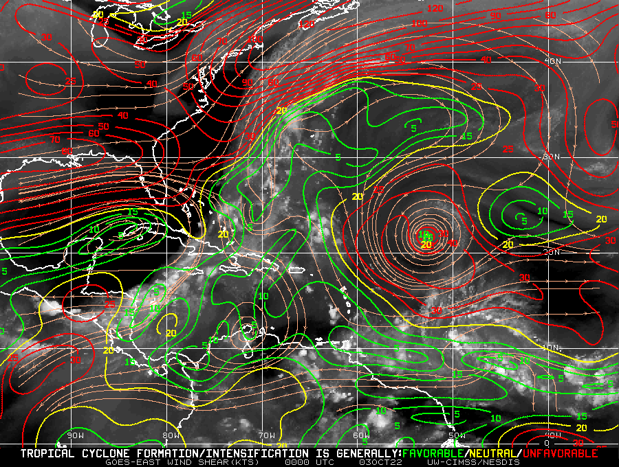
tropicwatch wrote:Currently the ULL is probably helping 91L's outflow.

https://tropicwatch.info/shear190010022022.jpg

That ULL isn’t going to budge during the next several days, and once 91L reaches the Lesser Antilles, it’ll start getting sheared. This is likely why model support is so mixed — some kill off 91L entirely, others have it survive. I don’t know whether the environment becomes better further west.
0 likes   
Irene '11 Sandy '12 Hermine '16 5/15/2018 Derecho Fay '20 Isaias '20 Elsa '21 Henri '21 Ida '21

I am only a meteorology enthusiast who knows a decent amount about tropical cyclones. Look to the professional mets, the NHC, or your local weather office for the best information.

User avatar
chris_fit
Category 5
Category 5
Posts: 3078
Joined: Wed Sep 10, 2003 11:58 pm
Location: Tampa Bay Area, FL
Contact:

Re: ATL: INVEST 91L - Discussion

#54 Postby chris_fit » Mon Oct 03, 2022 6:57 am

Doesn't look too bad this morning.

Image
4 likes   

User avatar
chris_fit
Category 5
Category 5
Posts: 3078
Joined: Wed Sep 10, 2003 11:58 pm
Location: Tampa Bay Area, FL
Contact:

Re: ATL: INVEST 91L - Discussion

#55 Postby chris_fit » Mon Oct 03, 2022 6:58 am

No Change in TWO

2. East of the Windward Islands:
Showers and thunderstorms associated with a tropical wave located
several hundred miles east of the southern Windward Islands have
become slightly better organized since yesterday. Some further
development of the wave is possible, and a tropical depression
could form within the next few days while it moves generally
westward at 15 to 20 mph, reaching the Windward Islands and the
eastern Caribbean Sea by midweek. Interests in the Windward Islands
should monitor the progress of the system.
* Formation chance through 48 hours...low...30 percent.
* Formation chance through 5 days...medium...40 percent.
0 likes   

User avatar
WiscoWx02
Category 1
Category 1
Posts: 340
Age: 21
Joined: Sat Jul 31, 2021 8:09 pm
Location: Minnesota

Re: ATL: INVEST 91L - Discussion

#56 Postby WiscoWx02 » Mon Oct 03, 2022 7:27 am

NotSparta wrote:
WiscoWx02 wrote:
NotSparta wrote:
This one won't be that kind either, would develop/strengthen too late


Do you think this wave has much of a chance at all? Hardly any model support but that upper level environment looks pretty favorable.


Probably has a decent chance. Strong wave moving into the Caribbean in October, and eventually finding favorable conditions there? Pretty common way to get development. Meteorology > modelology. Not to say it can't not develop, but you shouldn't throw out the potential of development just because models aren't enthused


Oh for sure…I remember models dropping Zeta in 2020 and we all remember how that went. I incorrectly interpreted your last post, I thought you were saying it probably wasn’t going to develop and was sort of curious why you thought why, opps :lol: Thank you!!!
3 likes   

User avatar
cycloneye
Admin
Admin
Posts: 139059
Age: 67
Joined: Thu Oct 10, 2002 10:54 am
Location: San Juan, Puerto Rico

Re: ATL: INVEST 91L - Discussion

#57 Postby cycloneye » Mon Oct 03, 2022 8:16 am

1 likes   
Visit the Caribbean-Central America Weather Thread where you can find at first post web cams,radars
and observations from Caribbean basin members Click Here

User avatar
Iceresistance
Category 5
Category 5
Posts: 8911
Age: 20
Joined: Sat Oct 10, 2020 9:45 am
Location: Tecumseh, OK/Norman, OK

Re: ATL: INVEST 91L - Discussion

#58 Postby Iceresistance » Mon Oct 03, 2022 8:40 am

ASCAT was going to make a direct hit, but the data failed.

Why does everything go wrong with ASCAT when we need it the most!? :roll:

EDIT: ASCAT is working, except the data is delayed.
0 likes   
Bill 2015 & Beta 2020

Winter 2020-2021 :cold:

All observations are in Tecumseh, OK unless otherwise noted.

Winter posts are focused mainly for Oklahoma & Texas.

Take any of my forecasts with a grain of salt, refer to the NWS, SPC, and NHC for official information

Never say Never with weather! Because ANYTHING is possible!

User avatar
MGC
S2K Supporter
S2K Supporter
Posts: 5792
Joined: Sun Mar 23, 2003 9:05 pm
Location: Pass Christian MS, or what is left.

Re: ATL: INVEST 91L - Discussion

#59 Postby MGC » Mon Oct 03, 2022 9:41 am

Got some spin down there this morning. Need a bit more convection to get the ball rolling. ULL to the north is not causing much shear over the system...just a little dry air. Something to keep an eye on.....MGC
5 likes   

User avatar
Iceresistance
Category 5
Category 5
Posts: 8911
Age: 20
Joined: Sat Oct 10, 2020 9:45 am
Location: Tecumseh, OK/Norman, OK

Re: ATL: INVEST 91L - Discussion

#60 Postby Iceresistance » Mon Oct 03, 2022 10:22 am

ASCAT has found 25 knot barbs to the east, but may have missed the LLC.
0 likes   
Bill 2015 & Beta 2020

Winter 2020-2021 :cold:

All observations are in Tecumseh, OK unless otherwise noted.

Winter posts are focused mainly for Oklahoma & Texas.

Take any of my forecasts with a grain of salt, refer to the NWS, SPC, and NHC for official information

Never say Never with weather! Because ANYTHING is possible!


Return to “2022”

Who is online

Users browsing this forum: No registered users and 52 guests