EPAC: JULIA - Remnants - Discussion

Moderator: S2k Moderators

Message
Author
jlauderdal
S2K Supporter
S2K Supporter
Posts: 6771
Joined: Wed May 19, 2004 5:46 am
Location: NE Fort Lauderdale
Contact:

Re: ATL: INVEST 91L - Discussion

#201 Postby jlauderdal » Wed Oct 05, 2022 7:59 am

cycloneye wrote:
kevin wrote:Another Caribbean cruiser, here we go again. As per tradition with these sort of invests on storm2k, here's my post saying 'this is gonna be a long thread'.


Is still early to the end but I can tell you that it looks like much less long than the 308 pages of Ian because it will not be a long duration cyclone and no U.S tracking.

Floridians do the heavy lifting on this board when it comes to content so when there is no threat to the sunshine state, the post count plummets like a dropsonde dropped from a plane. :D :D
4 likes   

User avatar
GCANE
S2K Supporter
S2K Supporter
Posts: 10787
Joined: Mon Oct 22, 2007 8:03 am

Re: ATL: INVEST 91L - Discussion

#202 Postby GCANE » Wed Oct 05, 2022 8:04 am

Recon is finding tons of west winds
0 likes   

User avatar
tropicwatch
Category 5
Category 5
Posts: 3205
Age: 60
Joined: Sat Jun 02, 2007 10:01 am
Location: Panama City Florida
Contact:

Re: ATL: INVEST 91L - Discussion

#203 Postby tropicwatch » Wed Oct 05, 2022 8:07 am

Looks like a couple of vortices in that area. Very disorganized.
0 likes   
Tropicwatch


Agnes 72', Eloise 75, Elena 85', Kate 85', Charley 86', Florence 88', Beryl 94', Dean 95', Erin 95', Opal 95', Earl 98', Georges 98', Ivan 2004', Arlene 2005', Dennis 2005', Ida 2009' Debby 2012' Irma 2017' Michael 2018'

User avatar
GCANE
S2K Supporter
S2K Supporter
Posts: 10787
Joined: Mon Oct 22, 2007 8:03 am

Re: ATL: INVEST 91L - Discussion

#204 Postby GCANE » Wed Oct 05, 2022 8:08 am

Likely, they'll tag this a TD at about 11.5N 61.3W
0 likes   

underthwx
Category 5
Category 5
Posts: 1928
Joined: Sat Jul 30, 2011 2:14 pm
Location: Brazoria County Texas

Re: ATL: INVEST 91L - Discussion

#205 Postby underthwx » Wed Oct 05, 2022 8:24 am

jlauderdal wrote:
cycloneye wrote:
kevin wrote:Another Caribbean cruiser, here we go again. As per tradition with these sort of invests on storm2k, here's my post saying 'this is gonna be a long thread'.


Is still early to the end but I can tell you that it looks like much less long than the 308 pages of Ian because it will not be a long duration cyclone and no U.S tracking.

Floridians do the heavy lifting on this board when it comes to content so when there is no threat to the sunshine state, the post count plummets like a dropsonde dropped from a plane. :D :D


With all my respects, maybe on the content, but there's no shortage of caring about each and every one of yall...promise you that my friend.....be well
2 likes   

User avatar
WiscoWx02
Category 1
Category 1
Posts: 340
Age: 21
Joined: Sat Jul 31, 2021 8:09 pm
Location: Minnesota

Re: ATL: INVEST 91L - Discussion

#206 Postby WiscoWx02 » Wed Oct 05, 2022 8:26 am

wxman57 wrote:Just a wave, still. It's going to be skirting the coast of South America until Saturday afternoon, which is when I have it becoming a TD/TS. It will be hard for it to develop with the southern half over land. Nicaragua is the target. Careful using radar to find a surface circulation, as the farther out from the radar site, the higher up you're looking for a circulation. It does remind me of Joan of 1988 or Cesar of 1996.


wxman57 is usually right about these things, probably going to not form till this weekend…idk about the ceiling on it though. Part of me says a Bonnie repeat while a part of me looks at Iota, Joan, Otto and thinks otherwise.
4 likes   

User avatar
Category5Kaiju
Category 5
Category 5
Posts: 3355
Age: 22
Joined: Thu Dec 24, 2020 12:45 pm
Location: Seattle

Re: ATL: INVEST 91L - Discussion

#207 Postby Category5Kaiju » Wed Oct 05, 2022 8:36 am

WiscoWx02 wrote:
wxman57 wrote:Just a wave, still. It's going to be skirting the coast of South America until Saturday afternoon, which is when I have it becoming a TD/TS. It will be hard for it to develop with the southern half over land. Nicaragua is the target. Careful using radar to find a surface circulation, as the farther out from the radar site, the higher up you're looking for a circulation. It does remind me of Joan of 1988 or Cesar of 1996.


wxman57 is usually right about these things, probably going to not form till this weekend…idk about the ceiling on it though. Part of me says a Bonnie repeat while a part of me looks at Iota, Joan, Otto and thinks otherwise.


Personally, I can't really see this being a Bonnie repeat. June had an abnormally sprawling and strong high pressure, which contributed to that storm being confined to SA (not to mention the speed shear it had to handle during that time, which is very usual for June). October climatology is simply not the same, and it is generally more favorable for westward tracking systems through the Caribbean for a reason.
5 likes   
Unless explicitly stated, all information covered in my posts is based on my opinions and observations. Please refer to a professional meteorologist or an accredited weather research agency otherwise, especially if serious decisions must be made in the event of a potentially life-threatening tropical storm or hurricane.

User avatar
wxman57
Moderator-Pro Met
Moderator-Pro Met
Posts: 22480
Age: 66
Joined: Sat Jun 21, 2003 8:06 pm
Location: Houston, TX (southwest)

Re: ATL: INVEST 91L - Discussion

#208 Postby wxman57 » Wed Oct 05, 2022 8:52 am

Doesn't look like it would qualify as a well-defined LLC. I don't think the NHC will call it a TD. It's a mess. My track has it moving into northern Nicaragua Sunday afternoon/evening as a 50kt TS. First becomes a TD Friday evening after passing Venezuela.
5 likes   

underthwx
Category 5
Category 5
Posts: 1928
Joined: Sat Jul 30, 2011 2:14 pm
Location: Brazoria County Texas

Re: ATL: INVEST 91L - Discussion

#209 Postby underthwx » Wed Oct 05, 2022 8:59 am

wxman57 wrote:Doesn't look like it would qualify as a well-defined LLC. I don't think the NHC will call it a TD. It's a mess. My track has it moving into northern Nicaragua Sunday afternoon/evening as a 50kt TS. First becomes a TD Friday evening after passing Venezuela.


Good enough for me Xman...let's hope it gets squashed and doesn't cause anyone any misery.....have a great day!
0 likes   

underthwx
Category 5
Category 5
Posts: 1928
Joined: Sat Jul 30, 2011 2:14 pm
Location: Brazoria County Texas

Re: ATL: INVEST 91L - Discussion

#210 Postby underthwx » Wed Oct 05, 2022 9:05 am

WiscoWx02 wrote:
wxman57 wrote:Just a wave, still. It's going to be skirting the coast of South America until Saturday afternoon, which is when I have it becoming a TD/TS. It will be hard for it to develop with the southern half over land. Nicaragua is the target. Careful using radar to find a surface circulation, as the farther out from the radar site, the higher up you're looking for a circulation. It does remind me of Joan of 1988 or Cesar of 1996.


wxman57 is usually right about these things, probably going to not form till this weekend…idk about the ceiling on it though. Part of me says a Bonnie repeat while a part of me looks at Iota, Joan, Otto and thinks otherwise.

Similar tracks you mean?
0 likes   

User avatar
tropicwatch
Category 5
Category 5
Posts: 3205
Age: 60
Joined: Sat Jun 02, 2007 10:01 am
Location: Panama City Florida
Contact:

Re: ATL: INVEST 91L - Discussion

#211 Postby tropicwatch » Wed Oct 05, 2022 9:19 am

wxman57 wrote:Doesn't look like it would qualify as a well-defined LLC. I don't think the NHC will call it a TD. It's a mess. My track has it moving into northern Nicaragua Sunday afternoon/evening as a 50kt TS. First becomes a TD Friday evening after passing Venezuela.


Think they might go with PTC.
0 likes   
Tropicwatch


Agnes 72', Eloise 75, Elena 85', Kate 85', Charley 86', Florence 88', Beryl 94', Dean 95', Erin 95', Opal 95', Earl 98', Georges 98', Ivan 2004', Arlene 2005', Dennis 2005', Ida 2009' Debby 2012' Irma 2017' Michael 2018'

User avatar
ColdMiser123
Professional-Met
Professional-Met
Posts: 778
Age: 27
Joined: Mon Sep 26, 2016 3:26 pm
Location: Northeast US

Re: ATL: INVEST 91L - Discussion

#212 Postby ColdMiser123 » Wed Oct 05, 2022 9:21 am

Center appears a bit broad, but there are plenty of west winds being found by recon, and more of a circulation than what the GFS thought at this point. GFS had no westerlies at all.

Since this has stayed weak up until now, it will be CA bound. Will be watching for any quick ramp up in intensity as conditions are quite favorable in the southwest Caribbean.
0 likes   
B.S., M.S., Meteorology & Atmospheric Science

Sciencerocks
Category 5
Category 5
Posts: 7286
Age: 38
Joined: Thu Jul 06, 2017 1:51 am

Re: ATL: INVEST 91L - Discussion

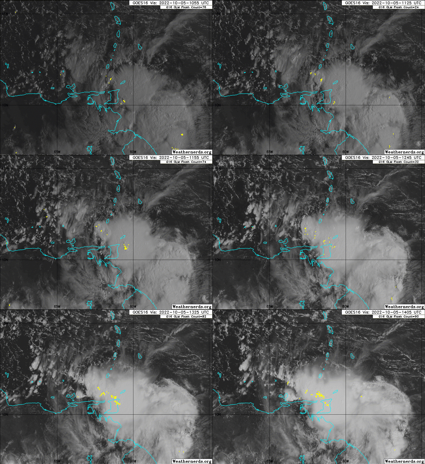
#213 Postby Sciencerocks » Wed Oct 05, 2022 9:23 am

Image
0 likes   

Hurricane Mike
Category 2
Category 2
Posts: 562
Joined: Tue Apr 10, 2018 7:44 am

Re: ATL: INVEST 91L - Discussion

#214 Postby Hurricane Mike » Wed Oct 05, 2022 9:35 am

Wow lots of lightning in those squalls.
0 likes   

User avatar
WiscoWx02
Category 1
Category 1
Posts: 340
Age: 21
Joined: Sat Jul 31, 2021 8:09 pm
Location: Minnesota

Re: ATL: INVEST 91L - Discussion

#215 Postby WiscoWx02 » Wed Oct 05, 2022 9:37 am

Category5Kaiju wrote:
WiscoWx02 wrote:
wxman57 wrote:Just a wave, still. It's going to be skirting the coast of South America until Saturday afternoon, which is when I have it becoming a TD/TS. It will be hard for it to develop with the southern half over land. Nicaragua is the target. Careful using radar to find a surface circulation, as the farther out from the radar site, the higher up you're looking for a circulation. It does remind me of Joan of 1988 or Cesar of 1996.


wxman57 is usually right about these things, probably going to not form till this weekend…idk about the ceiling on it though. Part of me says a Bonnie repeat while a part of me looks at Iota, Joan, Otto and thinks otherwise.


Personally, I can't really see this being a Bonnie repeat. June had an abnormally sprawling and strong high pressure, which contributed to that storm being confined to SA (not to mention the speed shear it had to handle during that time, which is very usual for June). October climatology is simply not the same, and it is generally more favorable for westward tracking systems through the Caribbean for a reason.


Yeah I agree with your thinking too which is why part of me wouldn't be shocked if it gets much stronger than Bonnie. But Wmman57...idk I like to think he's fairly spot on and he doesn't think it'll do much strength wise. Doesn't mean it won't do much flood wise though of course.
0 likes   

User avatar
Iceresistance
Category 5
Category 5
Posts: 8911
Age: 20
Joined: Sat Oct 10, 2020 9:45 am
Location: Tecumseh, OK/Norman, OK

Re: ATL: INVEST 91L - Discussion

#216 Postby Iceresistance » Wed Oct 05, 2022 9:57 am

0 likes   
Bill 2015 & Beta 2020

Winter 2020-2021 :cold:

All observations are in Tecumseh, OK unless otherwise noted.

Winter posts are focused mainly for Oklahoma & Texas.

Take any of my forecasts with a grain of salt, refer to the NWS, SPC, and NHC for official information

Never say Never with weather! Because ANYTHING is possible!

User avatar
Kazmit
Category 5
Category 5
Posts: 1915
Age: 21
Joined: Mon Jul 25, 2016 8:49 am
Location: Williamsburg VA for college, Bermuda otherwise

Re: ATL: INVEST 91L - Discussion

#217 Postby Kazmit » Wed Oct 05, 2022 10:01 am

WiscoWx02 wrote:
Category5Kaiju wrote:
WiscoWx02 wrote:

wxman57 is usually right about these things, probably going to not form till this weekend…idk about the ceiling on it though. Part of me says a Bonnie repeat while a part of me looks at Iota, Joan, Otto and thinks otherwise.


Personally, I can't really see this being a Bonnie repeat. June had an abnormally sprawling and strong high pressure, which contributed to that storm being confined to SA (not to mention the speed shear it had to handle during that time, which is very usual for June). October climatology is simply not the same, and it is generally more favorable for westward tracking systems through the Caribbean for a reason.


Yeah I agree with your thinking too which is why part of me wouldn't be shocked if it gets much stronger than Bonnie. But Wmman57...idk I like to think he's fairly spot on and he doesn't think it'll do much strength wise. Doesn't mean it won't do much flood wise though of course.

Intensity can be a wild card sometimes. Early on, Ian wasn’t supposed to be more than a low end cat 3 at most.
0 likes   
Igor 2010, Sandy 2012, Fay 2014, Gonzalo 2014, Joaquin 2015, Nicole 2016, Humberto 2019

I am only a tropical weather enthusiast. My predictions are not official and may or may not be backed by sound meteorological data. For official information, please refer to the NHC and NWS products.

User avatar
tropicwatch
Category 5
Category 5
Posts: 3205
Age: 60
Joined: Sat Jun 02, 2007 10:01 am
Location: Panama City Florida
Contact:

Re: ATL: INVEST 91L - Discussion

#218 Postby tropicwatch » Wed Oct 05, 2022 10:03 am

Doesn't look like the NHC is going to pull the trigger on anything yet.
0 likes   
Tropicwatch


Agnes 72', Eloise 75, Elena 85', Kate 85', Charley 86', Florence 88', Beryl 94', Dean 95', Erin 95', Opal 95', Earl 98', Georges 98', Ivan 2004', Arlene 2005', Dennis 2005', Ida 2009' Debby 2012' Irma 2017' Michael 2018'

User avatar
wxman57
Moderator-Pro Met
Moderator-Pro Met
Posts: 22480
Age: 66
Joined: Sat Jun 21, 2003 8:06 pm
Location: Houston, TX (southwest)

Re: ATL: INVEST 91L - Discussion

#219 Postby wxman57 » Wed Oct 05, 2022 10:06 am

underthwx wrote:
WiscoWx02 wrote:
wxman57 wrote:Just a wave, still. It's going to be skirting the coast of South America until Saturday afternoon, which is when I have it becoming a TD/TS. It will be hard for it to develop with the southern half over land. Nicaragua is the target. Careful using radar to find a surface circulation, as the farther out from the radar site, the higher up you're looking for a circulation. It does remind me of Joan of 1988 or Cesar of 1996.


wxman57 is usually right about these things, probably going to not form till this weekend…idk about the ceiling on it though. Part of me says a Bonnie repeat while a part of me looks at Iota, Joan, Otto and thinks otherwise.

Similar tracks you mean?


Yes, similar tracks to Cesar and Joan, but not similar intensity, necessarily.
2 likes   

User avatar
wxman57
Moderator-Pro Met
Moderator-Pro Met
Posts: 22480
Age: 66
Joined: Sat Jun 21, 2003 8:06 pm
Location: Houston, TX (southwest)

Re: ATL: INVEST 91L - Discussion

#220 Postby wxman57 » Wed Oct 05, 2022 10:10 am

tropicwatch wrote:
wxman57 wrote:Doesn't look like it would qualify as a well-defined LLC. I don't think the NHC will call it a TD. It's a mess. My track has it moving into northern Nicaragua Sunday afternoon/evening as a 50kt TS. First becomes a TD Friday evening after passing Venezuela.


Think they might go with PTC.


It doesn't meet the requirements for a PTC. First, there must be a high chance of development within 48 hours (it's medium now). Second, there must be a requirement for TS watches or warnings within 48 hours of possible impact. The A-B-C islands are in the path, but I'm not sure if the NHC issues watches/warnings for them. This disturbance will have a very hard time organizing with much of it being over land for the next 48 hrs. Time to issue an advisory on a SOuth Indian Ocean depression...
0 likes   


Return to “2022”

Who is online

Users browsing this forum: No registered users and 62 guests