EPAC: JULIA - Remnants - Discussion
Moderator: S2k Moderators
-
tropicwatch

- Category 5

- Posts: 3205
- Age: 60
- Joined: Sat Jun 02, 2007 10:01 am
- Location: Panama City Florida
- Contact:
Re: ATL: INVEST 91L - Discussion
Looks like HH is starting to fly a quadrant pattern now. Unless they are just staying at operational altitude for a little while before heading to the barn.
0 likes
Tropicwatch
Agnes 72', Eloise 75, Elena 85', Kate 85', Charley 86', Florence 88', Beryl 94', Dean 95', Erin 95', Opal 95', Earl 98', Georges 98', Ivan 2004', Arlene 2005', Dennis 2005', Ida 2009' Debby 2012' Irma 2017' Michael 2018'
Agnes 72', Eloise 75, Elena 85', Kate 85', Charley 86', Florence 88', Beryl 94', Dean 95', Erin 95', Opal 95', Earl 98', Georges 98', Ivan 2004', Arlene 2005', Dennis 2005', Ida 2009' Debby 2012' Irma 2017' Michael 2018'
-
Hurricane Mike
- Category 2

- Posts: 562
- Joined: Tue Apr 10, 2018 7:44 am
Re: ATL: INVEST 91L - Discussion
Here is a morning video update for those interested
https://www.youtube.com/watch?v=4dZy13aNVK4
https://www.youtube.com/watch?v=4dZy13aNVK4
0 likes
-
cycloneye

- Admin

- Posts: 139027
- Age: 67
- Joined: Thu Oct 10, 2002 10:54 am
- Location: San Juan, Puerto Rico
Re: ATL: INVEST 91L - Discussion
tropicwatch wrote:Looks like HH is starting to fly a quadrant pattern now. Unless they are just staying at operational altitude for a little while before heading to the barn.
The mission is over.
0 likes
Visit the Caribbean-Central America Weather Thread where you can find at first post web cams,radars
and observations from Caribbean basin members Click Here
and observations from Caribbean basin members Click Here
-
cycloneye
- Admin
- Posts: 139027
- Age: 67
- Joined: Thu Oct 10, 2002 10:54 am
- Location: San Juan, Puerto Rico
Re: ATL: INVEST 91L - Discussion
3 likes
Visit the Caribbean-Central America Weather Thread where you can find at first post web cams,radars
and observations from Caribbean basin members Click Here
and observations from Caribbean basin members Click Here
-
hurricanes1234
- Category 5
- Posts: 2903
- Joined: Sat Jul 28, 2012 6:19 pm
- Location: Trinidad and Tobago
Re: ATL: INVEST 91L - Discussion
I can confirm this. Northern parts of the island are currently experiencing severe flash flooding from this system and videos keep coming in of cars being swept away as well as houses being inundated. There's also a lot of traffic as large roadways linking east and west are completely impassable.
Flooding is common here during the wet season with afternoon thunderstorms and tropical waves but this is more intense.
3 likes
PLEASE NOTE: With the exception of information from weather agencies that I may copy and paste here, my posts will NEVER be official, since I am NOT a meteorologist. They are solely my amateur opinion, and may or may not be accurate. Therefore, please DO NOT use them as official details, particularly when making important decisions. Thank you.
-
Iceresistance

- Category 5
- Posts: 8910
- Age: 20
- Joined: Sat Oct 10, 2020 9:45 am
- Location: Tecumseh, OK/Norman, OK
Re: ATL: INVEST 91L - Discussion
ASCAT has made a direct hit, still no LLC.
0 likes
Bill 2015 & Beta 2020
Winter 2020-2021
All observations are in Tecumseh, OK unless otherwise noted.
Winter posts are focused mainly for Oklahoma & Texas.
Take any of my forecasts with a grain of salt, refer to the NWS, SPC, and NHC for official information
Never say Never with weather! Because ANYTHING is possible!
Winter 2020-2021
All observations are in Tecumseh, OK unless otherwise noted.
Winter posts are focused mainly for Oklahoma & Texas.
Take any of my forecasts with a grain of salt, refer to the NWS, SPC, and NHC for official information
Never say Never with weather! Because ANYTHING is possible!
-
cycloneye
- Admin
- Posts: 139027
- Age: 67
- Joined: Thu Oct 10, 2002 10:54 am
- Location: San Juan, Puerto Rico
Re: ATL: INVEST 91L - Discussion
Iceresistance wrote:ASCAT has made a direct hit, still no LLC.
Where is the graphic?
0 likes
Visit the Caribbean-Central America Weather Thread where you can find at first post web cams,radars
and observations from Caribbean basin members Click Here
and observations from Caribbean basin members Click Here
-
tropicwatch
- Category 5
- Posts: 3205
- Age: 60
- Joined: Sat Jun 02, 2007 10:01 am
- Location: Panama City Florida
- Contact:
Re: ATL: INVEST 91L - Discussion
cycloneye wrote:Iceresistance wrote:ASCAT has made a direct hit, still no LLC.
Where is the graphic?
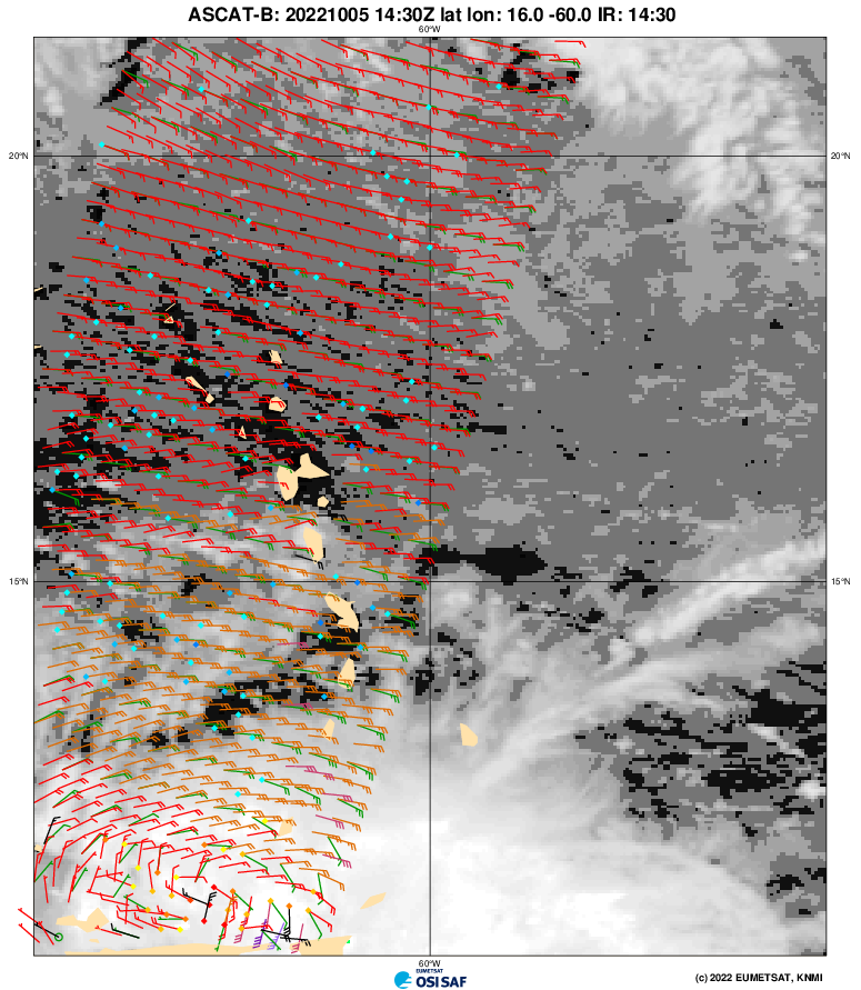
1 likes
Tropicwatch
Agnes 72', Eloise 75, Elena 85', Kate 85', Charley 86', Florence 88', Beryl 94', Dean 95', Erin 95', Opal 95', Earl 98', Georges 98', Ivan 2004', Arlene 2005', Dennis 2005', Ida 2009' Debby 2012' Irma 2017' Michael 2018'
Agnes 72', Eloise 75, Elena 85', Kate 85', Charley 86', Florence 88', Beryl 94', Dean 95', Erin 95', Opal 95', Earl 98', Georges 98', Ivan 2004', Arlene 2005', Dennis 2005', Ida 2009' Debby 2012' Irma 2017' Michael 2018'

Re: ATL: INVEST 91L - Discussion
tropicwatch wrote:cycloneye wrote:Iceresistance wrote:ASCAT has made a direct hit, still no LLC.
Where is the graphic?
https://tropicwatch.info/ascat1430z.png
Is that not an LLC....?
3 likes
-
tropicwatch
- Category 5
- Posts: 3205
- Age: 60
- Joined: Sat Jun 02, 2007 10:01 am
- Location: Panama City Florida
- Contact:
Re: ATL: INVEST 91L - Discussion
Teban54 wrote:
Is that not an LLC....?
It is also the vicinity the HH was flying in.
0 likes
Tropicwatch
Agnes 72', Eloise 75, Elena 85', Kate 85', Charley 86', Florence 88', Beryl 94', Dean 95', Erin 95', Opal 95', Earl 98', Georges 98', Ivan 2004', Arlene 2005', Dennis 2005', Ida 2009' Debby 2012' Irma 2017' Michael 2018'
Agnes 72', Eloise 75, Elena 85', Kate 85', Charley 86', Florence 88', Beryl 94', Dean 95', Erin 95', Opal 95', Earl 98', Georges 98', Ivan 2004', Arlene 2005', Dennis 2005', Ida 2009' Debby 2012' Irma 2017' Michael 2018'
-
skyline385

- Category 5
- Posts: 2444
- Age: 33
- Joined: Wed Aug 26, 2020 11:15 pm
- Location: Palm Beach County FL
ATL: INVEST 91L - Discussion
It looks like it is getting hit pretty hard by what looks like a PV streamer, some of the models showed it too


Sent from my iPhone using Tapatalk
Sent from my iPhone using Tapatalk
0 likes
-
Aric Dunn
- Category 5
- Posts: 21228
- Age: 41
- Joined: Sun Sep 19, 2004 9:58 pm
- Location: Ready for the Chase.
- Contact:
Re: ATL: INVEST 91L - Discussion
Now that the broad circ has tiled and the southerly surge has picked up we are starting to see the circ tighten and getting better curvature.

Last edited by Aric Dunn on Wed Oct 05, 2022 12:21 pm, edited 1 time in total.
4 likes
Note: If I make a post that is brief. Please refer back to previous posts for the analysis or reasoning. I do not re-write/qoute what my initial post said each time.
If there is nothing before... then just ask
Space & Atmospheric Physicist, Embry-Riddle Aeronautical University,
I believe the sky is falling...
If there is nothing before... then just ask
Space & Atmospheric Physicist, Embry-Riddle Aeronautical University,
I believe the sky is falling...

Re: ATL: INVEST 91L - Discussion
skyline385 wrote:It looks like it is getting hit pretty hard by what looks like a PV streamer, some of the models showed it too
https://uploads.tapatalk-cdn.com/20221005/10092e9656ddfe46950ee868fbb69c10.gif
https://uploads.tapatalk-cdn.com/20221005/634d63fce7530f83ec9b05229fbc4570.gif
Sent from my iPhone using Tapatalk
That would explain why most of the convection is over SA or right on the coast. It might outrun the PVS in the next day or so and will probably have better odds of TCG then.
0 likes
Irene '11 Sandy '12 Hermine '16 5/15/2018 Derecho Fay '20 Isaias '20 Elsa '21 Henri '21 Ida '21
I am only a meteorology enthusiast who knows a decent amount about tropical cyclones. Look to the professional mets, the NHC, or your local weather office for the best information.
I am only a meteorology enthusiast who knows a decent amount about tropical cyclones. Look to the professional mets, the NHC, or your local weather office for the best information.
-
cheezyWXguy

- Category 5
- Posts: 5528
- Joined: Mon Feb 13, 2006 12:29 am
- Location: Dallas, TX
Re: ATL: INVEST 91L - Discussion
Aric Dunn wrote:Now that the broad circ has tiled and the southerly surge has picked up we are starting to see the circ tighten and getting better curvature.
https://i.ibb.co/yqwwHTH/ezgif-com-gif-maker-60.gif
Was just gonna post about this. Hadn’t seen radar til your post, but looking at visible, the circulation looks pretty elongated w-e, like there’s a string of vorticity centers. Ascat shows this elongation as well. The inflow coming off of SA and the surface boundaries to the north make it look as though there may be a center near or just west of Tobago, and it looks like your radar confirms that. Granted the radar is seeing aloft, but given the convection I could see that working to the surface.
0 likes
-
cycloneye
- Admin
- Posts: 139027
- Age: 67
- Joined: Thu Oct 10, 2002 10:54 am
- Location: San Juan, Puerto Rico
Re: ATL: INVEST 91L - Discussion
Tropical Weather Outlook
NWS National Hurricane Center Miami FL
200 PM EDT Wed Oct 5 2022
For the North Atlantic...Caribbean Sea and the Gulf of Mexico:
Eastern Caribbean Sea:
Surface observations and data from an Air Force Reserve
reconnaissance aircraft mission this morning indicate that the
broad area of low pressure located over the far southeastern
Caribbean Sea does not have a well-defined center. Although the
system is producing a large area of showers and thunderstorms over
the southern Windward Islands and adjacent waters, satellite and
radar imagery from Barbados show that it is not well organized.
The system is forecast to move generally westward near the northern
coast of South America, and interaction with land is likely to
hinder significant development during the next day or so. After
that time, environmental conditions are expected to become more
conducive for development, and a tropical depression is likely to
form within the next two to three days when the system is over the
south-central Caribbean Sea.
Regardless of development, heavy rainfall with localized flooding,
as well as gusty winds to gale force, are expected over portions of
the Windward Islands, northern portions of South America, and the
ABC Islands during the next day or two. Interests in those
locations, in addition to those in Central America, should continue
to monitor the progress of this system.
* Formation chance through 48 hours...medium...60 percent.
* Formation chance through 5 days...high...80 percent.
0 likes
Visit the Caribbean-Central America Weather Thread where you can find at first post web cams,radars
and observations from Caribbean basin members Click Here
and observations from Caribbean basin members Click Here


-
wxman57

- Moderator-Pro Met

- Posts: 22480
- Age: 66
- Joined: Sat Jun 21, 2003 8:06 pm
- Location: Houston, TX (southwest)
Re: ATL: INVEST 91L - Discussion
From the NHC outlook:
The system is forecast to move generally westward near the northern
coast of South America, and interaction with land is likely to
hinder significant development during the next day or so. After
that time, environmental conditions are expected to become more
conducive for development, and a tropical depression is likely to
form within the next two to three days when the system is over the
south-central Caribbean Sea.
Who would have thought development was not likely until it passes Venezuela (in 48 hrs)?
3 likes
-
cheezyWXguy
- Category 5
- Posts: 5528
- Joined: Mon Feb 13, 2006 12:29 am
- Location: Dallas, TX
Re: ATL: INVEST 91L - Discussion
wxman57 wrote:From the NHC outlook:
The system is forecast to move generally westward near the northern
coast of South America, and interaction with land is likely to
hinder significant development during the next day or so. After
that time, environmental conditions are expected to become more
conducive for development, and a tropical depression is likely to
form within the next two to three days when the system is over the
south-central Caribbean Sea.
Who would have thought development was not likely until it passes Venezuela (in 48 hrs)?
This is the first I’m hearing of it. Rumors have it there’s a pro met on this board (a “weatherman” if you will) who could have offered some insight. If only he would have chimed in
1 likes
Re: ATL: INVEST 91L - Discussion
Would a PTC designation have been appropriate in this situation? Flooding looks very concerning.
0 likes
Andrew (1992), Irene (1999), Frances (2004), Katrina (2005), Wilma (2005), Fay (2008), Irma (2017), Eta (2020), Ian (2022)
-
wxman57
- Moderator-Pro Met
- Posts: 22480
- Age: 66
- Joined: Sat Jun 21, 2003 8:06 pm
- Location: Houston, TX (southwest)
Re: ATL: INVEST 91L - Discussion
Nuno wrote:Would a PTC designation have been appropriate in this situation? Flooding looks very concerning.
Heavy rain and wind gusts to tropical storm strength are common with just about every moderate tropical wave. That's not enough to begin advisories. Just hold your horses, NHC will begin advisories by Friday morning, as a TS watch will be needed for Nicaragua and 91L will likely be a TD at some point on Friday.
0 likes
Who is online
Users browsing this forum: No registered users and 29 guests