Still hard to tell using IR and LR radar - But I believe the next TWO will have a bit more aggressive wording with it. Not sure if they will mention that a depression could be forming, though with the proximity to land it wouldn't be surprising.
Not much movement at all either.
Tropical Depression HUMBERTO Discussion & Images
Moderator: S2k Moderators
-
Stratosphere747
- Category 5

- Posts: 3772
- Joined: Thu Sep 11, 2003 8:34 pm
- Location: Surfside Beach/Freeport Tx
- Contact:
-
Matt-hurricanewatcher
Re: Invest 90L up again,West GOM-Discussion & Images
There is NO depression forming at this moment. This system is a lot like 92L with a MLC and convection forming on top of it, but the difference is it has a sharp surface trough. Only about 50-80 miles offshore Texas, but a surface trough none the less. Could it close off near the northern side? I say if enough convection forms and forms convergents in turn allowing a LLC to form. Sure, I give this a 20 percent chance of becoming something.
0 likes
-
southerngale

- Retired Staff

- Posts: 27418
- Joined: Thu Oct 10, 2002 1:27 am
- Location: Southeast Texas (Beaumont area)
Re: Invest 90L up again,West GOM-Discussion & Images
From a tiny dot of convection to this in just 4 hours:

It was obvious on radar that it was going to look better after the eclipse, but it looks better than I expected. It shouldn't be anything more than another heavy rainmaker for Texas, but interesting nonetheless.
It was obvious on radar that it was going to look better after the eclipse, but it looks better than I expected. It shouldn't be anything more than another heavy rainmaker for Texas, but interesting nonetheless.
0 likes
-
Stormcenter
- S2K Supporter

- Posts: 6689
- Joined: Wed Sep 03, 2003 11:27 am
- Location: Houston, TX
Re: Invest 90L up again,West GOM-Discussion & Images
Matt-hurricanewatcher wrote:There is NO depression forming at this moment. This system is a lot like 92L with a MLC and convection forming on top of it, but the difference is it has a sharp surface trough. Only about 50-80 miles offshore Texas, but a surface trough none the less. Could it close off near the northern side? I say if enough convection forms and forms convergents in turn allowing a LLC to form. Sure, I give this a 20 percent chance of becoming something.
I'm sorry but I disagree with your odds.
0 likes
-
Matt-hurricanewatcher
Re: Invest 90L up again,West GOM-Discussion & Images
Stormcenter wrote:Matt-hurricanewatcher wrote:There is NO depression forming at this moment. This system is a lot like 92L with a MLC and convection forming on top of it, but the difference is it has a sharp surface trough. Only about 50-80 miles offshore Texas, but a surface trough none the less. Could it close off near the northern side? I say if enough convection forms and forms convergents in turn allowing a LLC to form. Sure, I give this a 20 percent chance of becoming something.
I'm sorry but I disagree with your odds.
The buoys show a eastly winds from brownsville Texas lat north Along the coastline. To the east around 95 west there is some southeast winds...But that shows there is still a surface trough with in the area. The MLC is what is forming the convection, we have to watch closely for a LLC to form down to the surface. Also I'm putting the fact that they(nhc) has not upgraded 91L, a system that looks about 500 times more organized to anything yet into my odds.
0 likes

-
Extremeweatherguy

- Category 5
- Posts: 11095
- Joined: Mon Oct 10, 2005 8:13 pm
- Location: Florida
Well one thing that stands out is that fact that most of the models are now running on this system. Last night there were only 3 running.
https://my.sfwmd.gov/sfwmd/common/image ... orm_90.gif
(sorry, i didn't have time to upload the image on photobucket)
https://my.sfwmd.gov/sfwmd/common/image ... orm_90.gif
(sorry, i didn't have time to upload the image on photobucket)
0 likes
-
Cryomaniac
- Category 5
- Posts: 1289
- Joined: Tue Aug 15, 2006 2:26 pm
- Location: Newark, Nottinghamshire, UK
- Contact:

-
Extremeweatherguy
- Category 5
- Posts: 11095
- Joined: Mon Oct 10, 2005 8:13 pm
- Location: Florida
-
Meso

- Category 5
- Posts: 1609
- Age: 39
- Joined: Mon Aug 09, 2004 12:14 pm
- Location: South Africa
- Contact:
8am TWD
THE AREA OF LOW PRES IN THE NW GULF HAS BECOME BETTER ORGANIZED
OVERNIGHT. AS OF 09Z...THE LOW WAS ANALYZED NEAR 27N95W 1008
MB...WHICH IS 2 MB LOWER THAN OBSERVED 3 HOURS EARLIER AT 06Z.
IN ACCORDANCE...SHIP AND BUOY DATA DEPICT AN INCREASE IN WINDS
WITH THE HIGHEST REPORT NEAR 29 KT E OF THE CENTER. HOWEVER
...THIS REPORT SEEMS SUSPECT AND UNREPRESENTATIVE WHEN COMPARED
TO THE SURROUNDING 10-20 KT REPORTS. THESE OBSERVATIONS ALSO
REVEAL THAT THIS SYSTEM IS STILL AN ELONGATED N-S TROUGH
AXIS...THOUGH DOPPLER RADAR AND SATELLITE IMAGERY CLEARLY SHOW
AN IMPROVED AREA OF CYCLONIC TURNING TO THE CLOUD AND RAIN
ELEMENTS. PROBABLY THE CLEAREST INDICATION OF THE IMPROVED
STRUCTURE IS THE INCREASED SHOWER ACTIVITY WHICH HAS STARTED TO
SPREAD ACROSS EXTREME SE TEXAS. CURRENTLY SCATTERED SHOWERS AND
TSTMS ARE ROUGHLY WITHIN 90-120 NM OF THE LOW. ENVIRONMENTAL
CONDITIONS APPEAR TO BE CONDUCIVE FOR SOME DEVELOPMENT OF THIS
SYSTEM OVER THE NEXT DAY OR SO AS IT DRIFTS SLOWLY
WEST-NORTHWESTWARD.
0 likes

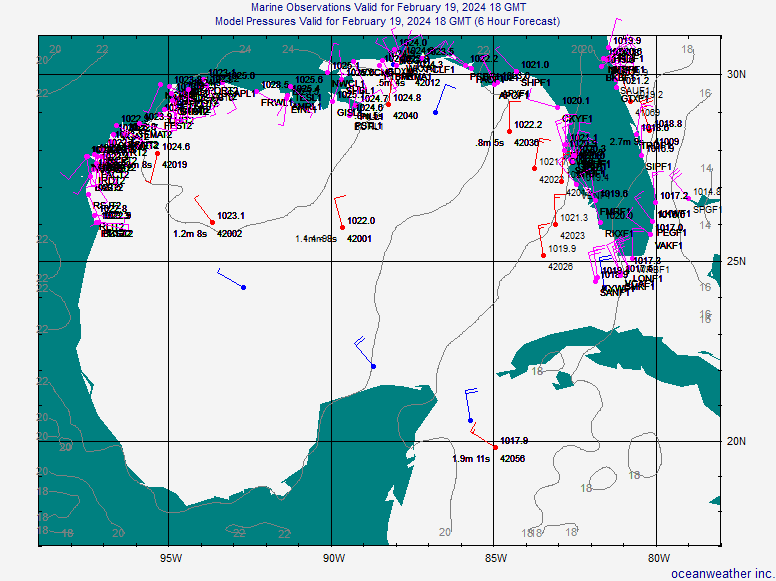
Re: Invest 90L up again,West GOM-Discussion & Images
Pressures have fallen overnight at buoy 42016, down to near 1008mb:
http://www.ndbc.noaa.gov/show_plot.php? ... wdpr&uom=E
Winds have also turned to NNW over the past hour there.
http://www.ndbc.noaa.gov/station_page.php?station=42019
It's looking more organized the recent days on satellite imagery and there is definitely an area low pressure spinning there, but maybe not closed entirely. Winds don't seem to be very strong either. But I do think it could develop, since it's not moving much.
0 likes

-
HURAKAN

- Professional-Met

- Posts: 46084
- Age: 39
- Joined: Thu May 20, 2004 4:34 pm
- Location: Key West, FL
- Contact:
Re: Invest 90L up again,West GOM-Discussion & Images
Station FGBL1 - High Island 334
28.12 N 93.67 W (28°7'6" N 93°40'12" W)
09 12 5:46 am S 22.0 25.1 - - - - - - 81.9 - - - - -
09 12 5:31 am SSE 25.1 28.0 - - - - - - 81.5 - - - - -
09 12 5:16 am S 22.9 25.1 - - - - - - 82.4 - - - - -
09 12 5:01 am S 24.1 26.0 - - - - - - 82.2 - - - - -
09 12 4:46 am SSE 27.0 28.0 - - - - - - 82.4 - - - - -
09 12 4:31 am S 26.0 28.9 - - - - - - 82.4 - - - - -
09 12 4:16 am SSE 24.1 28.9 - - - - - - 82.4 - - - - -
09 12 4:01 am S 22.9 25.1 - - - - - - 82.9 - - - - -
09 12 3:46 am S 25.1 28.0 - - - - - - 83.3 - - - - -
09 12 3:31 am SSE 26.0 28.9 - - - - - - 82.6 - - - - -
09 12 3:16 am S 24.1 27.0 - - - - - - 82.9 - - - - -
09 12 3:01 am SSE 25.1 28.0 - - - - - - 82.9 - - - - -
09 12 2:46 am S 26.0 29.9 - - - - - - 83.1 - - - - -
09 12 2:31 am SSE 27.0 31.1 - - - - - - 81.7 - - - - -
09 12 2:16 am SE 27.0 29.9 - - - - - - 82.2 - - - - -
09 12 2:00 am SE 22.0 25.1 - - - - - - 79.2 - - - - -
09 12 1:46 am SSE 28.9 33.0 - - - - - - 80.2 - - - - -
09 12 1:31 am SSE 22.0 24.1 - - - - - - 81.7 - - - - -
09 12 1:16 am SE 21.0 24.1 - - - - - - 82.0 - - - - -
09 12 1:01 am SE 22.9 26.0 - - - - - - 81.5 - - - - -
09 12 12:46 am SSE 26.0 28.0 - - - - - - 81.5 - - - - -
09 12 12:31 am SSE 22.0 24.1 - - - - - - 81.3 - - - - -
09 12 12:16 am SSE 21.0 24.1 - - - - - - 81.3 - - - - -
09 12 12:01 am SSE 19.0 21.0
If these reports are valid, then the report of the ship could also be valid. I will not be the first time a system organizing in the GOM jumps to a tropical storm from the first advisory.
0 likes
-
Matt-hurricanewatcher
Re: Invest 90L up again,West GOM-Discussion & Images
Maybe a LLC is starting to close off. I'm sorry the buoy center buoy's had no northwestly wind reports. Also I can't get into that site right now. But this system could get numbered? 91L sets the goal post...
0 likes


-
Extremeweatherguy
- Category 5
- Posts: 11095
- Joined: Mon Oct 10, 2005 8:13 pm
- Location: Florida
The "center of circulation" looks to be stationary east of Corpus and south of Houston a couple of hundred miles offshore. Based on that satellite and radar image..as well as surface reports..I feel that a depression could be declared by 11am or 5pm today (possibly even a TS if it continues getting it's act together and stronger winds are reported). We shall see what the NHC decides to do..
0 likes

Re:
Extremeweatherguy wrote:Well one thing that stands out is that fact that most of the models are now running on this system. Last night there were only 3 running.
https://my.sfwmd.gov/sfwmd/common/image ... orm_90.gif
(sorry, i didn't have time to upload the image on photobucket)
That model plot looks like a 5 year old got a hold of the map with a box of crayons.
0 likes
-
Cryomaniac
- Category 5
- Posts: 1289
- Joined: Tue Aug 15, 2006 2:26 pm
- Location: Newark, Nottinghamshire, UK
- Contact:
Re:
Extremeweatherguy wrote:The "center of circulation" looks to be stationary east of Corpus and south of Houston a couple of hundred miles offshore. Based on that satellite and radar image..as well as surface reports..I feel that a depression could be declared by 11am or 5pm today (possibly even a TS if it continues getting it's act together and stronger winds are reported). We shall see what the NHC decides to do..
Just as a matter of intrest, which gets which name if these are both upgraded to TS at 11? I presume this get Humberto and 91L gets Ingrid?
0 likes
Who is online
Users browsing this forum: No registered users and 46 guests