CAT 5 Hurricane Dean - Archived threads

Moderator: S2k Moderators

Message
Author
User avatar
Agua
Category 5
Category 5
Posts: 1138
Joined: Thu Jul 31, 2003 4:54 pm
Location: Biloxi, Mississippi

Re:

#1401 Postby Agua » Tue Aug 14, 2007 12:26 pm

Steve wrote: In fact, if I was a moderator, it would be open to anyone, but those who I thought were guilty, I'd temporarily ban them to fight out model runs in that particular area until things were more conclusive.
:D

Steve

I think that's an excellent idea. The only criteria for temporary banishment would be them being from the state they predict landfall where said landfall is outside the cone.
0 likes   

destruction92
Category 1
Category 1
Posts: 312
Joined: Sun Jul 22, 2007 10:43 pm

Re: Tropical Storm Dean (pg.28) - Discussions, Analysis and Sats

#1402 Postby destruction92 » Tue Aug 14, 2007 12:28 pm

Derek what do you think about the GFS doing another major shift in its long range forecast track?
Will this encounter another major change or is Dean set for the Gulf of Mexico?
0 likes   

User avatar
ekal
Tropical Storm
Tropical Storm
Posts: 210
Age: 36
Joined: Thu Aug 25, 2005 11:13 am
Location: Miami, Florida

Re:

#1403 Postby ekal » Tue Aug 14, 2007 12:29 pm

Derek Ortt wrote:Dean looks great on vis

But is IR was all we had, this thing would not even be classified as a depression. Its really just holding its own as a weak TS at the moment


I think the relatively warm cloud tops are due to the stable air this system has been injesting. A large expanse of stratocumulus clouds continues to be entrained into the circulation. Do you think that will hinder strengthening, Derek?
0 likes   

User avatar
Jevo
S2K Supporter
S2K Supporter
Posts: 1729
Age: 47
Joined: Tue Aug 03, 2004 8:45 pm
Location: The Flemish Cap
Contact:

Re: T Storm Dean - Global Models=12z GFS,CMC Posted

#1404 Postby Jevo » Tue Aug 14, 2007 12:29 pm

Throw your models out the window. This storm is going through the Herbert Box on its current forcast track

Image

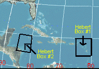
This image shows the two Hebert boxes. If Floridians want an indication of a possible hit they need to keep an eye on any hurricane that passes through these boxes. Nearly every major Hurricane that hit S Florida since 1900 passed through these boxes. When major Hurricanes miss these boxes,they virtually always miss South Florida. If a major Hurricane moves into these boxes South Florida really needs to watch out. These boxes approx 335 miles x 335 miles includes the Virgin Islands but not Puerto Rico. The pattern has proven accurate for 9 out of 10 storms storms that developed & hit Dade,Broward & Palm Bch Counties. The following is a list showing Hurricanes that passed through these Boxes,starting with Box #1.

1950 Baker--Alabama....
1950 Dog--out to sea....
1951 Charlie--Yucatan/Mexico....
1952 Baker-- out to sea....
1953 Carol--Nova scotia....
1954 ALice--Leeward isl out to sea....
1955 Connie--N Carolina....
1955 Ione--N Carolina....
1956 Betsy--N Antilles, PR,Bahamas....
1958 Fifi--out to sea....
1958 Ilsa--out to sea....
1960 DonnaN Antilles,Bahamas,Fla,east seaboard....
1963 Edith--windward isl,PR,Hispaniola....
1964 Cleo--N Antilles,Hispaniola,Haiti,Cuba,Fla....
1966 Faith--N Antilles....
1966 Inez--N Antilles,Hispaniola,Haiti,Cuba,Bahamas,Fla,Yucatan,Mex....
1967Beulah--Hispaniola,Yucata,S Texas....
1975 Eloise--Hispaniola,Fla panhandle....
1979 David--Antilles,Hispaniola,Haiti,Fla,Ga,Sc....
1984 Klaus--out to sea....
1985 Gloria--NE U.S....
1989 dean--Bermuda,Newfoundland....
1989 Hugo--N Antilles,PR,SC....
1990 Klaus-- out to sea....
1995 Luis--N Antilles,New foundland....
1995 Marilyn--N antilles,VI.PR....
1996 Bertha--N antilles,VI,PR,N carolina....
1996 Fran--N Carolina....
1996 Hortense--PR,Nova scotia....
1997 Erika--out to sea....
1998 Georges--N antilles,VI,PR,Hispaniola,Haiti,Cuba,Keys,mississippi....
1999 Jose--N antilles,VI....
1999 Lenny--N antilles....
2000 Debby--n antilles,VI,Hispaniola....
2004 FrancesBahamas,Treasure coast,Fla....
0 likes   

User avatar
storms in NC
S2K Supporter
S2K Supporter
Posts: 2338
Joined: Thu Jul 28, 2005 2:58 pm
Location: Wallace,NC 40 miles NE of Wilm
Contact:

#1405 Postby storms in NC » Tue Aug 14, 2007 12:31 pm

You can see in the last loop a jump to the north.
http://www.ssd.noaa.gov/goes/flt/t1/loop-vis.html

Don't think it is any one storm but the Islands right now.
You will see a flop back and forth till this TS Dean can make up his mine what he wants to do. If he stays like he is then it will be straight into Nicaragua. If he slows down to catch his self then he can build or deepen and become a Hurricane and then you will see a more northern turn. Into where Don't know till it gets to about 55-60 then we can have a better grasp on it. But till We really know what the ridge is really going to do is any ones guess. So lets see what we can do for the people in the Islands now. Then worry later if it will be a Gulf or Fla Or EC. Pick a straw.lllllll1llllllll
0 likes   

User avatar
jasons2k
Storm2k Executive
Storm2k Executive
Posts: 8245
Age: 51
Joined: Wed Jul 06, 2005 12:32 pm
Location: The Woodlands, TX

Re: T Storm Dean - Global Models=12z GFS,CMC Posted

#1406 Postby jasons2k » Tue Aug 14, 2007 12:32 pm

The problem is that this is a show. Whenever the GFS hints at a Texas landfall, people start crediting it...but then when GFS predicts Dean out to sea or skirting NC, then most of the people here say that it is bogus.

Funny how people stop ranting at the GFS when it conveniently changes its track back to Texas (only to be followed thereafter by another major shift and criticism re-emerging).


There's good reason for that. What the GFS did yesterday made no sense. I called it "bogus" then and if it flip-flops again, I'll call it "bogus" again too. Unless I see a clear reason why either 1) this will get picked-up by a trough or 2) the ridge collapses and it goes north, I will call the GFS "bogus" every time it plows Dean into the ridge. No flip-flopping here.
Last edited by jasons2k on Tue Aug 14, 2007 12:35 pm, edited 1 time in total.
0 likes   

User avatar
cycloneye
Admin
Admin
Posts: 145464
Age: 68
Joined: Thu Oct 10, 2002 10:54 am
Location: San Juan, Puerto Rico

Re: T Storm Dean - Global Models=12z GFS,CMC Posted

#1407 Postby cycloneye » Tue Aug 14, 2007 12:33 pm


069
WHXX04 KWBC 141728
CHGQLM
ATTENTION...NATIONAL HURRICANE CENTER

NCEP COUPLED GFDL HURRICANE MODEL FORECAST MADE FOR

TROPICAL DEPRESSION FOUR 04L

INITIAL TIME 12Z AUG 14

DISCLAIMER ... THIS INFORMATION IS PROVIDED AS GUIDANCE. IT
REQUIRES INTERPRETATION BY HURRICANE SPECIALISTS AND SHOULD
NOT BE CONSIDERED AS A FINAL PRODUCT. PLEASE SEE THE TPC/NHC
OFFICIAL FORECAST.


FORECAST STORM POSITION

HOUR LATITUDE LONGITUDE HEADING/SPEED(KT)

0 11.6 38.7 260./20.0
6 12.1 39.6 297./10.8
12 12.3 40.9 280./12.5
18 12.5 42.5 277./15.7
24 12.6 44.5 272./19.1
30 12.8 46.2 277./17.6
36 12.8 48.0 268./16.7
42 12.8 49.9 273./19.0
48 13.0 51.7 275./17.1
54 13.1 53.6 273./19.4
60 13.2 55.3 273./16.5
66 13.3 57.1 274./16.9
72 13.4 59.1 273./19.5
78 13.3 60.8 265./16.8
84 13.4 62.1 274./12.8
90 13.7 63.7 280./16.0
96 13.9 65.6 277./18.0
102 13.9 67.1 271./14.5
108 14.2 68.5 284./14.0
114 14.4 70.2 275./17.1
120 14.6 72.0 277./17.3
126 14.3 73.6 260./15.6


12z GFDL Caribbean bound.
0 likes   

User avatar
storms in NC
S2K Supporter
S2K Supporter
Posts: 2338
Joined: Thu Jul 28, 2005 2:58 pm
Location: Wallace,NC 40 miles NE of Wilm
Contact:

Re: Re:

#1408 Postby storms in NC » Tue Aug 14, 2007 12:33 pm

Dean4Storms wrote:
Steve wrote:Canadian looks interesting and mirrors the WPAC. It's bringing an elongated N-S ridge down from Canada to merge up with the Bermuda High. = Westward bound.

>>The problem is that this is a show. Whenever the GFS hints at a Texas landfall, people start crediting it...but then when GFS predicts Dean out to sea or skirting NC, then most of the people here say that it is bogus.

I say that all the time. I coined the term STATECASTING. I think there should be a sub-sub forum where people can argue between Texas and North Carolina and Texas and Florida. People always jump on the runs that impact them. It's a weather forum phenominon not exclusive to Storm2k. In fact, if I was a moderator, it would be open to anyone, but those who I thought were guilty, I'd temporarily ban them to fight out model runs in that particular area until things were more conclusive. That way people could keep score on the worst offenders and determine if they had any real credibility.

:D

Steve


This is one Floridian who hopes it goes out to sea or to Texas or anywhere else but here. I've already had to replace my homeowners insurance because AllState bailed.


So did my Daughter Dean. She was so mad you could really see fire come out of her mouth.
0 likes   

User avatar
vacanechaser
Category 5
Category 5
Posts: 1461
Joined: Wed Dec 03, 2003 9:34 pm
Location: Portsmouth, Va
Contact:

Re:

#1409 Postby vacanechaser » Tue Aug 14, 2007 12:35 pm

storms in NC wrote:You can see in the last loop a jump to the north.
http://www.ssd.noaa.gov/goes/flt/t1/loop-vis.html

Don't think it is any one storm but the Islands right now.
You will see a flop back and forth till this TS Dean can make up his mine what he wants to do. If he stays like he is then it will be straight into Nicaragua. If he slows down to catch his self then he can build or deepen and become a Hurricane and then you will see a more northern turn. Into where Don't know till it gets to about 55-60 then we can have a better grasp on it. But till We really know what the ridge is really going to do is any ones guess. So lets see what we can do for the people in the Islands now. Then worry later if it will be a Gulf or Fla Or EC. Pick a straw.lllllll1llllllll


dont see a jump north.. looks like the convection to me.. jmo... looks like it may be right on track or maybe a tick south of the forecast points...


Jesse V. Bass III
http://www.vastormphoto.com
Hurrciane Intercept Research Team
0 likes   

Dean4Storms
S2K Supporter
S2K Supporter
Posts: 6358
Age: 62
Joined: Sun Aug 31, 2003 1:01 pm
Location: Miramar Bch. FL

Re:

#1410 Postby Dean4Storms » Tue Aug 14, 2007 12:38 pm

storms in NC wrote:You can see in the last loop a jump to the north.
http://www.ssd.noaa.gov/goes/flt/t1/loop-vis.html

Don't think it is any one storm but the Islands right now.
You will see a flop back and forth till this TS Dean can make up his mine what he wants to do. If he stays like he is then it will be straight into Nicaragua. If he slows down to catch his self then he can build or deepen and become a Hurricane and then you will see a more northern turn. Into where Don't know till it gets to about 55-60 then we can have a better grasp on it. But till We really know what the ridge is really going to do is any ones guess. So lets see what we can do for the people in the Islands now. Then worry later if it will be a Gulf or Fla Or EC. Pick a straw.lllllll1llllllll


I don't think it was a jump either, just convection expanding in the upper Levels.

See the loop here from RAMSDIS.......

http://www1.cira.colostate.edu/ramm/rms ... PICAL.html
0 likes   

Dean4Storms
S2K Supporter
S2K Supporter
Posts: 6358
Age: 62
Joined: Sun Aug 31, 2003 1:01 pm
Location: Miramar Bch. FL

#1411 Postby Dean4Storms » Tue Aug 14, 2007 12:39 pm

Its now clearly past 40w
0 likes   

User avatar
storms in NC
S2K Supporter
S2K Supporter
Posts: 2338
Joined: Thu Jul 28, 2005 2:58 pm
Location: Wallace,NC 40 miles NE of Wilm
Contact:

Re: Re:

#1412 Postby storms in NC » Tue Aug 14, 2007 12:40 pm

vacanechaser wrote:
storms in NC wrote:You can see in the last loop a jump to the north.
http://www.ssd.noaa.gov/goes/flt/t1/loop-vis.html

Don't think it is any one storm but the Islands right now.
You will see a flop back and forth till this TS Dean can make up his mine what he wants to do. If he stays like he is then it will be straight into Nicaragua. If he slows down to catch his self then he can build or deepen and become a Hurricane and then you will see a more northern turn. Into where Don't know till it gets to about 55-60 then we can have a better grasp on it. But till We really know what the ridge is really going to do is any ones guess. So lets see what we can do for the people in the Islands now. Then worry later if it will be a Gulf or Fla Or EC. Pick a straw.lllllll1llllllll


dont see a jump north.. looks like the convection to me.. jmo... looks like it may be right on track or maybe a tick south of the forecast points...


Jesse V. Bass III
http://www.vastormphoto.com
Hurrciane Intercept Research Team


Maybe the old eyes here. Most likely it is the clouds moving away from the low.To make it look like it.
0 likes   

User avatar
windstorm99
S2K Supporter
S2K Supporter
Posts: 1578
Age: 47
Joined: Sat May 26, 2007 8:10 am
Location: Miami, Florida
Contact:

Re: T Storm Dean - Global Models=12z GFS,CMC,GFDL Posted

#1413 Postby windstorm99 » Tue Aug 14, 2007 12:40 pm

I think you will definately see a change in the nhc's cone after the lastest GFDL...

Image
0 likes   

User avatar
El Nino
Category 1
Category 1
Posts: 454
Age: 47
Joined: Sun Oct 16, 2005 3:18 pm
Location: Lima - Miraflores (Peru)
Contact:

Re: T Storm Dean - Global Models=12z GFS,CMC,GFDL Posted

#1414 Postby El Nino » Tue Aug 14, 2007 12:41 pm

Hmmm GFDL well to the South
0 likes   

destruction92
Category 1
Category 1
Posts: 312
Joined: Sun Jul 22, 2007 10:43 pm

Re: T Storm Dean - Global Models=12z GFS,CMC Posted

#1415 Postby destruction92 » Tue Aug 14, 2007 12:42 pm

jschlitz wrote:
The problem is that this is a show. Whenever the GFS hints at a Texas landfall, people start crediting it...but then when GFS predicts Dean out to sea or skirting NC, then most of the people here say that it is bogus.

Funny how people stop ranting at the GFS when it conveniently changes its track back to Texas (only to be followed thereafter by another major shift and criticism re-emerging).


There's good reason for that. What the GFS did yesterday made no sense. I called it "bogus" then and it it flip-flops again, I'll call it "bogus" again too. Unless I see a clear reason why either 1) this will get picked-up by a trough or 2) the ridge collapses and it goes north, I will call the GFS "bogus" every time it plows Dean into the ridge. No flip-flopping here.


But that's the problem...the GFS did not "plow Dean into the ridge". It showed a weakening ridge under the influence of an approaching trough. These models run on logarithms and do not show two contradictory things like what you suggested when Dean went "plowing" through the ridge...What would have been a better way to phrase that statement would be that "Dean got pulled in through a weakness between the ridges just off the east coast, which the GFS clearly depicted on yesterday's run.

So what I am seeing here is arbitrary cherry-picking of the GFS models that support a strong ridge scenario over a weakening ridge scenario.

Yesterday's GFS run graphic did show why Dean would 1) get picked up by a trough and 2) how the ridge partially eroded off the east coast around Bermuda so that Dean could go in a more northerly direction.
0 likes   

User avatar
HURAKAN
Professional-Met
Professional-Met
Posts: 46086
Age: 38
Joined: Thu May 20, 2004 4:34 pm
Location: Key West, FL
Contact:

#1416 Postby HURAKAN » Tue Aug 14, 2007 12:44 pm

The consensus farther south is because of a stronger ridge or a weaker storm?
0 likes   

Brent
S2K Supporter
S2K Supporter
Posts: 38094
Age: 37
Joined: Sun May 16, 2004 10:30 pm
Location: Tulsa Oklahoma
Contact:

Re: T Storm Dean - Global Models=12z GFS,CMC,GFDL Posted

#1417 Postby Brent » Tue Aug 14, 2007 12:45 pm

Models still inconsistent even for the islands...
0 likes   

User avatar
punkyg
Category 2
Category 2
Posts: 770
Joined: Mon Apr 23, 2007 7:37 pm
Location: sanford florida

#1418 Postby punkyg » Tue Aug 14, 2007 12:46 pm

When will Dean get into more favorable conditions to develop further?
0 likes   

User avatar
windstorm99
S2K Supporter
S2K Supporter
Posts: 1578
Age: 47
Joined: Sat May 26, 2007 8:10 am
Location: Miami, Florida
Contact:

Re: T Storm Dean - Global Models=12z GFS,CMC,GFDL Posted

#1419 Postby windstorm99 » Tue Aug 14, 2007 12:47 pm

Lots of time to watch but expect a track change from the NHC if not at 5pm then later tonight with now the UKMET,GFDL and the GFS all going south.
Last edited by windstorm99 on Tue Aug 14, 2007 12:48 pm, edited 1 time in total.
0 likes   

User avatar
Weatherfreak14
Category 5
Category 5
Posts: 1383
Joined: Sat Sep 24, 2005 3:40 pm
Location: Beaufort, SC
Contact:

Re: T Storm Dean - Global Models=12z GFS,CMC,GFDL Posted

#1420 Postby Weatherfreak14 » Tue Aug 14, 2007 12:48 pm

A big difference in the models today, makes me really wonder what this storm will really do. Im still leaning on a treack towards the WNW towards the east coast but my mind could change if most models switch back to the Carribean into the gulf.
0 likes   


Return to “2007”

Who is online

Users browsing this forum: No registered users and 1 guest