Hurricane NOEL : Discussions & Images
Moderator: S2k Moderators


-
Stratosphere747
- Category 5

- Posts: 3772
- Joined: Thu Sep 11, 2003 8:34 pm
- Location: Surfside Beach/Freeport Tx
- Contact:
Re: Tropical Storm NOEL : Discussions & Images
gatorcane wrote:BigA wrote:Wow, convection is exploding to the southwest. I dont think this necessarily means much intensification (although it could) but I've never seen a system with so much black-top infrared.
I have with Wilma
Me to -
Invest 98L from a few years back that never was even classified....
0 likes
cantore said the high wind advisory was due to the high pressure being the dominant feature
and the tropical storm watches and warnings simply mean the tropical cyclone is the more dominant feature
now if the tropical storm warnings get issued inland , most likely we would see winds just a tad bit stronger than we have already experienced ........so reallly no biggie
the bahamas are the one's with the issue
0 likes
-
CrazyC83
- Professional-Met

- Posts: 34315
- Joined: Tue Mar 07, 2006 11:57 pm
- Location: Deep South, for the first time!
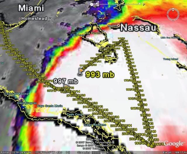
URNT15 KNHC 010347
AF304 1016A NOEL HDOB 28 20071101
033530 2350N 07800W 8420 01497 9990 +187 +169 120032 032 020 010 00
033600 2349N 07801W 8417 01497 9993 +179 +179 123036 037 023 010 00
033630 2348N 07803W 8420 01495 9991 +180 +180 124034 035 024 011 00
033700 2346N 07804W 8418 01497 9988 +183 +183 125037 038 029 011 00
033730 2345N 07805W 8432 01482 9994 +172 +172 128035 037 031 012 00
033800 2344N 07806W 8418 01493 9993 +170 +170 128042 043 031 011 00
033830 2343N 07808W 8421 01489 9988 +172 +172 118036 039 032 011 00
033900 2342N 07809W 8419 01486 9983 +177 +177 114030 031 030 010 00
033930 2340N 07810W 8421 01482 9977 +183 +178 115029 030 033 009 00
034000 2339N 07812W 8420 01478 9973 +182 +182 118031 033 033 009 00
034030 2338N 07813W 8420 01478 9969 +186 +186 115030 031 031 010 00
034100 2337N 07814W 8418 01478 9973 +176 +176 112031 033 033 010 00
034130 2336N 07816W 8418 01476 9977 +164 +164 112035 036 033 011 00
034200 2334N 07817W 8416 01475 9969 +172 +172 112030 033 030 010 00
034230 2333N 07818W 8419 01469 9973 +163 +163 109026 029 030 011 00
034300 2332N 07820W 8423 01460 9958 +179 +179 111021 021 030 011 00
034330 2331N 07821W 8417 01466 9953 +185 +185 104021 021 029 010 03
034400 2329N 07822W 8423 01458 9946 +192 +181 095020 021 029 010 00
034430 2328N 07823W 8419 01458 9937 +201 +181 080017 018 028 031 03
034500 2326N 07824W 8419 01454 9931 +208 +186 071013 014 023 010 03
$$
;
Pressure 993mb and not in the core yet...
0 likes

Re: Tropical Storm NOEL : Discussions & Images
OK I was just looking at the old images of Cat5 Wilma and you all definitely have a point about that having more black-top Unfortunately at that time in 2005 I did not have access to the internet. No worries though.
Last edited by BigA on Wed Oct 31, 2007 10:47 pm, edited 1 time in total.
0 likes
-
'CaneFreak

- Category 5
- Posts: 1487
- Joined: Mon Jun 05, 2006 10:50 am
- Location: New Bern, NC
Re: Tropical Storm NOEL : Discussions & Images
cpdaman wrote:lets see derek pointed out earlier that the model that predicted the loop earlier today called for another loop, then a move to the n and then ne
so another little loop tonite is not out of the question IMO
the question i have is how close are the winds that will actually steer this thing in a direction (presumably north, and then north east at a DECENT rate of speed)
Not far. The system is getting deeper and deeper and the deeper it gets the better the chance it will NOT do another loop and it will go ahead and move NE this time. BTW, I hope you read my physics analogy in the previous pages because that is EXACTLY what is going on.
0 likes
-
gatorcane

- S2K Supporter

- Posts: 23708
- Age: 48
- Joined: Sun Mar 13, 2005 3:54 pm
- Location: Boca Raton, FL
Pressures are rising across SE Florida:
W PALM BEACH PTCLDY 79 72 79 E14 29.82S
FT LAUDER-EXEC PTCLDY 79 72 78 NE16G29 29.79S
FT LAUDERDALE MOCLDY 81 71 71 NE18G25 29.78R
POMPANO BEACH PTCLDY 79 72 78 E22G28 29.80R
PEMBROKE PINES LGT RAIN 78 72 81 NE16 29.80S
OPA LOCKA MOCLDY 79 73 82 NE15G24 29.78S
MIAMI RAIN 79 72 79 NE17G23 29.78R
MIAMI BEACH N/A 80 75 84 NE28G39 N/A
WEST KENDALL CLOUDY 78 73 84 NE15 29.77R
HOMESTEAD PTCLDY 78 74 87 NE21G28 29.76S
0 likes
-
Evil Jeremy

- S2K Supporter
- Posts: 5463
- Age: 32
- Joined: Mon Apr 10, 2006 2:10 pm
- Location: Los Angeles, CA
Re: Tropical Storm NOEL : Discussions & Images
As I said on the previous page, every morning has provided us with a new suprise, so nothing is out of the question for tommorow morning. Heck, we are already seeing an expansion of the storm's western side! Also, wont the fact that the storm is not aligned and the fact that the winds are weak near the center effect where the storm will go?
0 likes
-
destruction92
- Category 1

- Posts: 312
- Joined: Sun Jul 22, 2007 10:43 pm
Re:
Vortex wrote:This has really expaned significantly to the SW..This is the last direction I would of expected the storm to expand towards...Mystery continues..
What is the latest direction of movement of Noel reported by RECON or the Hurricane Hunters? Anyone? Please?
0 likes
-
cycloneye

- Admin

- Posts: 149579
- Age: 69
- Joined: Thu Oct 10, 2002 10:54 am
- Location: San Juan, Puerto Rico
Re: Tropical Storm NOEL Recon discussion
Plane has not reached the center and the pressure has dropped to 993 mbs.
0 likes

-
CrazyC83
- Professional-Met
- Posts: 34315
- Joined: Tue Mar 07, 2006 11:57 pm
- Location: Deep South, for the first time!
Re: Tropical Storm NOEL Recon discussion
cycloneye wrote:Plane has not reached the center and the pressure has dropped to 993 mbs.
Correct, and surface winds were still 23 kt at that point, so it should be a bit lower still - around 991mb is my guess.
0 likes
Who is online
Users browsing this forum: No registered users and 32 guests