Hurricane NOEL : Discussions & Images
Moderator: S2k Moderators

-
CrazyC83
- Professional-Met

- Posts: 34315
- Joined: Tue Mar 07, 2006 11:57 pm
- Location: Deep South, for the first time!
URNT15 KNHC 020159
AF306 1216A NOEL HDOB 38 20071102
014730 2533N 07450W 6966 03086 9965 +098 +098 217070 073 051 003 03
014800 2532N 07450W 6960 03095 9965 +101 +101 218070 071 050 003 03
014830 2530N 07450W 6970 03088 9965 +101 +101 217070 070 050 003 00
014900 2529N 07450W 6965 03090 9961 +106 +103 216068 069 050 001 00
014930 2528N 07450W 6971 03086 9959 +108 +099 216067 067 049 002 00
015000 2527N 07450W 6965 03094 9965 +104 +096 213069 070 048 003 00
015030 2526N 07450W 6963 03100 9967 +103 +103 213065 066 048 004 03
015100 2525N 07451W 6957 03110 9973 +101 +101 215064 064 999 999 03
015130 2526N 07452W 6964 03100 9990 +114 +999 212063 064 999 999 05
015200 2528N 07452W 6964 03092 9990 +111 +999 214065 067 049 001 05
015230 2530N 07452W 6967 03089 9990 +101 +999 210067 068 049 002 01
015300 2532N 07451W 6966 03094 9973 +094 +094 211067 068 049 003 03
015330 2534N 07451W 6964 03091 9965 +100 +100 213070 071 050 003 00
015400 2537N 07450W 6967 03087 9960 +103 +103 211068 069 050 002 00
015430 2539N 07450W 6971 03081 9959 +104 +104 212065 066 050 002 00
015500 2541N 07450W 6969 03083 9959 +102 +102 215064 065 050 002 00
015530 2543N 07450W 6963 03088 9958 +102 +102 213065 066 049 004 00
015600 2545N 07450W 6967 03083 9959 +100 +100 212067 068 050 006 00
015630 2547N 07450W 6964 03086 9959 +100 +100 210067 068 050 005 00
015700 2550N 07449W 6969 03082 9955 +104 +104 208066 067 049 005 00
$$
;
Hurricane wind field rapidly spreading.
0 likes
-
Ed Mahmoud
Re:
Derek Ortt wrote:there would not be a game if that forecast verifies
I'd love to see a game played in 50 or 60 mph winds. Beacon Hill is inland, maybe 20 miles from the harbor. My late Grandmother lived in Quincy. Of course, without power the street cars wouldn't run.
You may have a point, they may not have a backup generator for the stadium lights.
0 likes
-
CrazyC83
- Professional-Met
- Posts: 34315
- Joined: Tue Mar 07, 2006 11:57 pm
- Location: Deep South, for the first time!
Re: Re:
Ed Mahmoud wrote:Derek Ortt wrote:there would not be a game if that forecast verifies
I'd love to see a game played in 50 or 60 mph winds. Beacon Hill is inland, maybe 20 miles from the harbor. My late Grandmother lived in Quincy. Of course, without power the street cars wouldn't run.
You may have a point, they may not have a backup generator for the stadium lights.
It isn't just that; it could be extremely dangerous for the fans to get to the stadium.
0 likes
-
Derek Ortt
-
wxman57

- Moderator-Pro Met

- Posts: 23175
- Age: 68
- Joined: Sat Jun 21, 2003 8:06 pm
- Location: Houston, TX (southwest)
Re: Hurricane NOEL : Discussions & Images
cycloneye wrote:wxman57,one more hurricane for the pool in your office.But you will still be short of your number right?
Right, Noel needs to split into 3 separate hurricanes all named "Noel" - two of them majors to get my 14/8/4
0 likes
-
cycloneye

- Admin

- Posts: 149568
- Age: 69
- Joined: Thu Oct 10, 2002 10:54 am
- Location: San Juan, Puerto Rico
Re: Hurricane NOEL : Discussions & Images
wxman57 wrote:cycloneye wrote:wxman57,one more hurricane for the pool in your office.
Right, Noel needs to split into 3 separate hurricanes all named "Noel" - two of them majors to get my 14/8/4
However,it will be two more below your 8 as Karen for sure will be upgraded to hurricane in the cyclone report.
0 likes


This is really going to be something else. Makes me want to learn a lot about these types of systems in more detail (ET cyclones).
This is just another piece of 2007 Atlantic hurricane season and I never get tired of this. What's really crazy is this is a La Nina and there wasn't any hurricanes in October but there was one in November.
This is just another piece of 2007 Atlantic hurricane season and I never get tired of this. What's really crazy is this is a La Nina and there wasn't any hurricanes in October but there was one in November.
0 likes
-
CrazyC83
- Professional-Met
- Posts: 34315
- Joined: Tue Mar 07, 2006 11:57 pm
- Location: Deep South, for the first time!
URNT15 KNHC 020209
AF306 1216A NOEL HDOB 39 20071102
015730 2552N 07449W 6964 03084 9958 +099 +099 207067 069 048 004 00
015800 2554N 07449W 6969 03079 9955 +101 +101 209067 069 049 006 00
015830 2556N 07449W 6966 03081 9973 +088 +088 206069 071 050 008 00
015900 2558N 07449W 6969 03080 9979 +083 +083 204068 069 049 009 00
015930 2601N 07448W 6975 03073 9957 +100 +100 203067 070 046 004 00
020000 2603N 07448W 6966 03082 9956 +100 +100 201067 068 047 002 00
020030 2605N 07448W 6967 03084 9954 +101 +101 200067 068 046 002 00
020100 2607N 07448W 6967 03077 9951 +102 +102 200067 068 049 004 00
020130 2609N 07448W 6965 03078 9956 +096 +096 198066 066 049 009 00
020200 2612N 07448W 6955 03089 9965 +090 +090 195074 077 048 010 00
020230 2614N 07447W 6964 03078 9952 +098 +098 195072 074 047 006 00
020300 2616N 07447W 6968 03075 9946 +103 +103 195072 072 047 003 00
020330 2619N 07447W 6971 03074 9939 +109 +105 194069 070 045 002 00
020400 2621N 07447W 6964 03075 9941 +106 +103 195070 071 044 001 00
020430 2623N 07447W 6967 03076 9945 +102 +102 195071 072 046 002 00
020500 2626N 07446W 6967 03073 9945 +100 +100 196070 071 047 000 00
020530 2628N 07446W 6965 03071 9942 +102 +102 198069 070 046 001 00
020600 2630N 07446W 6966 03071 9943 +102 +102 197069 069 047 001 00
020630 2633N 07446W 6965 03072 9937 +106 +103 196066 068 048 002 00
020700 2635N 07446W 6963 03074 9935 +105 +104 196065 066 048 002 00
$$
;
77 kt FL.
0 likes
-
brunota2003

- S2K Supporter

- Posts: 9476
- Age: 35
- Joined: Sat Jul 30, 2005 9:56 pm
- Location: Stanton, KY...formerly Havelock, NC
- Contact:
Re:
brunota2003 wrote:Wow...
THIS FORECAST PATTERN
RESULTS IN A TRACK FOR NOEL A LITTLE CLOSER TO THE U.S. EAST
COAST...AND WITH THE FORECAST EXPANSION OF THE WIND RADII...IS
EXPECTED TO RESULT IN A SIGNIFICANT EXTRATROPICAL WIND EVENT FROM
THE NORTH CAROLINA OUTER BANKS NORTHWARD. PLEASE CONSULT STATEMENTS
FROM YOUR NWS LOCAL FORECAST OFFICE. THE OFFICIAL FORECAST HAS BEEN
ADJUSTED WESTWARD FROM THE PREVIOUS ADVISORY BUT IS STILL TO THE
RIGHT OF THE MODEL CONSENSUS. ADDITIONAL WESTWARD ADJUSTMENTS MAY
BE NECESSARY THIS EVENING.
So, I missed a lot while I was gone...With this new data, what are the chances higher winds come on the NC coast? The very coastal counties (Cateret, Mainland Hyde and Dare) are under wind advisories and The OBX are at High Wind Warnings...what are the chances of those being pushed inland, now? Especially if the track shifts westward? They are already saying 20-25 mph here, so almost advisory criteria as it is...Any westward shift, resulting in much higher winds, would catch a bunch of people off guard...
Also, most importantly, what kind of westward shift? (as in, how far west would we be talking?)
Just reposting, to make sure it was not overlooked.
0 likes
-
CrazyC83
- Professional-Met
- Posts: 34315
- Joined: Tue Mar 07, 2006 11:57 pm
- Location: Deep South, for the first time!
URNT15 KNHC 020219
AF306 1216A NOEL HDOB 40 20071102
020730 2637N 07446W 6967 03073 9931 +109 +105 196064 065 047 001 00
020800 2639N 07445W 6965 03072 9936 +105 +105 196064 065 048 000 00
020830 2642N 07445W 6971 03066 9933 +107 +104 197064 065 047 002 00
020900 2644N 07445W 6973 03058 9928 +111 +093 196063 064 048 000 00
020930 2646N 07445W 6967 03064 9927 +110 +091 192061 062 049 002 00
021000 2648N 07445W 6965 03068 9933 +107 +094 193063 064 048 001 00
021030 2650N 07444W 6965 03069 9936 +105 +097 194063 063 050 000 00
021100 2653N 07444W 6967 03068 9931 +107 +102 192063 063 049 001 00
021130 2655N 07444W 6967 03066 9930 +109 +095 192063 064 049 001 00
021200 2657N 07444W 6967 03069 9931 +109 +089 192061 062 049 001 00
021230 2659N 07444W 6964 03070 9934 +107 +092 192063 065 049 001 00
021300 2702N 07444W 6969 03068 9946 +097 +097 191065 066 048 003 00
021330 2704N 07443W 6967 03071 9945 +099 +099 191065 066 048 003 00
021400 2706N 07443W 6971 03060 9944 +099 +099 193067 069 046 006 00
021430 2709N 07443W 6958 03073 9951 +090 +090 188075 080 051 011 00
021500 2711N 07443W 6956 03075 9957 +074 +074 180082 088 059 020 01
021530 2714N 07443W 6963 03063 9990 +070 +999 173075 077 058 025 05
021600 2716N 07442W 6961 03070 9990 +074 +999 176082 088 058 021 01
021630 2718N 07442W 6961 03066 9956 +081 +081 180080 082 055 019 00
021700 2721N 07442W 6972 03052 9965 +073 +073 177084 086 056 023 00
$$
;
88 kt FL (supports 80 kt at 90%)
0 likes
-
cycloneye
- Admin
- Posts: 149568
- Age: 69
- Joined: Thu Oct 10, 2002 10:54 am
- Location: San Juan, Puerto Rico
Re: Hurricane NOEL Recon discussion
88kts at flight level and plane has not reached the center.Hmm this thing is growing stronger very fast.
0 likes
-
brunota2003
- S2K Supporter
- Posts: 9476
- Age: 35
- Joined: Sat Jul 30, 2005 9:56 pm
- Location: Stanton, KY...formerly Havelock, NC
- Contact:
-
CrazyC83
- Professional-Met
- Posts: 34315
- Joined: Tue Mar 07, 2006 11:57 pm
- Location: Deep South, for the first time!
Re: Hurricane NOEL Recon discussion
cycloneye wrote:88kts at flight level and plane has not reached the center.Hmm this thing is growing stronger very fast.
That is at 3,000 ft as well...which supports 79 kt. I'd say we have at least a 75 kt storm right now.
My pressure guess is 975mb.
0 likes
-
CrazyC83
- Professional-Met
- Posts: 34315
- Joined: Tue Mar 07, 2006 11:57 pm
- Location: Deep South, for the first time!
URNT15 KNHC 020229
AF306 1216A NOEL HDOB 41 20071102
021730 2724N 07442W 6968 03061 9972 +070 +070 173081 083 055 018 00
021800 2726N 07442W 6978 03044 9963 +075 +075 172081 084 057 015 00
021830 2728N 07441W 6960 03066 9945 +090 +090 179082 085 057 014 00
021900 2731N 07441W 6969 03057 9959 +081 +081 175085 088 054 015 00
021930 2733N 07441W 6967 03058 9964 +076 +076 170084 085 054 013 00
022000 2736N 07441W 6968 03063 9974 +070 +070 167083 085 054 011 00
022030 2738N 07441W 6971 03058 9966 +079 +079 161081 084 052 010 00
022100 2741N 07440W 6979 03051 9970 +077 +077 162083 086 051 012 00
022130 2743N 07440W 6955 03083 9980 +072 +072 154076 079 051 012 00
022200 2746N 07440W 6968 03067 9983 +071 +071 158071 074 050 013 00
022230 2748N 07440W 6964 03081 9986 +073 +073 163071 073 050 016 00
022300 2750N 07440W 6967 03075 9990 +072 +072 161072 074 050 014 00
022330 2753N 07439W 6964 03083 9989 +076 +076 163071 074 050 014 00
022400 2755N 07439W 6964 03087 9990 +081 +081 164066 066 050 010 03
022430 2757N 07438W 6964 03093 9992 +080 +080 162062 067 053 011 00
022500 2759N 07437W 6968 03089 0007 +070 +070 152060 062 055 017 00
022530 2800N 07436W 6973 03081 0029 +052 +052 141055 061 055 020 01
022600 2802N 07435W 6946 03115 0028 +056 +056 149053 058 055 021 00
022630 2804N 07434W 6968 03094 0023 +061 +061 144058 064 054 017 00
022700 2806N 07433W 6957 03108 0027 +058 +058 145064 067 052 016 03
$$
;
More FL winds in the 80s.
0 likes
Re: Hurricane NOEL Recon discussion
cycloneye wrote:88kts at flight level and plane has not reached the center.Hmm this thing is growing stronger very fast.
Noel is becoming big boy.
0 likes
-
tolakram
- Admin
- Posts: 20186
- Age: 62
- Joined: Sun Aug 27, 2006 8:23 pm
- Location: Florence, KY (name is Mark)
Re: Hurricane NOEL : Discussions & Images

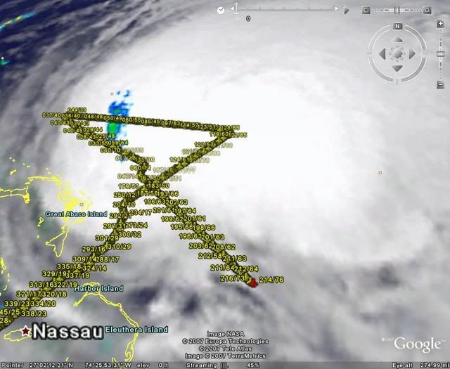
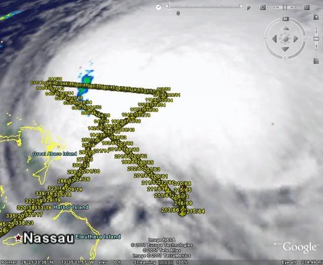
Possible *eye like* feature forming on the lower left of the blob but the convection is being thrown out in front. Doesn't look very healthy, but who can argue with the winds.
http://www.ssd.noaa.gov/goes/flt/t1/loop-jsl.html
0 likes
Who is online
Users browsing this forum: No registered users and 36 guests