CAT 5 Hurricane Dean - Archived threads
Moderator: S2k Moderators
-
PTrackerLA

- Category 5

- Posts: 5281
- Age: 42
- Joined: Thu Oct 10, 2002 8:40 pm
- Location: Lafayette, LA
Re: 12z GFS,NOGAPS,CMC,UKMET,GFDL Posted,EURO Shortly
0 likes
-
windstorm99

- S2K Supporter

- Posts: 1578
- Age: 48
- Joined: Sat May 26, 2007 8:10 am
- Location: Miami, Florida
- Contact:
Re: Hurricane DEAN:(Page 106) Discussions, Analysis and Imagery
I would think the HWRF is over doing things a bit cause if not we are talking about a storm just about as strong as wilma at her peak.
0 likes
-
hurricanefloyd5

- Category 5
- Posts: 1659
- Age: 45
- Joined: Sun May 02, 2004 10:53 am
- Location: Spartanburg
- Contact:
Re: Hurricane DEAN:(Page 106) Discussions, Analysis and Imagery
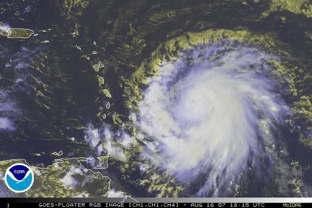
now that is very very scary aric... that reminds me of Hurricane Wilma at her strongest peak this Mean Dean could become a Cat.5 aric????
0 likes
-
DESTRUCTION5

- Category 5
- Posts: 4430
- Age: 44
- Joined: Wed Sep 03, 2003 11:25 am
- Location: Stuart, FL
Re: 12z GFS,NOGAPS,CMC,UKMET,GFDL Posted,EURO Shortly
Sabanic wrote:DESTRUCTION5 wrote:cycloneye wrote:Yes,lets take a break from the 12z runs and focus tonight on the 00z guidance that will have the data ingested from the gulfstream jet.
I don't think they will change much...previous storms have proven that..
Huh?
I don't know the facts on it but just by observation last year they were more trouble than they were worth..Inputed not inputed..Very confusing and the shifts in tracks were minimal, and yes i meant in the long run..
0 likes

Re: Re:
tronbunny wrote:caribepr wrote:I know I may be over-sensitive here...but adjectives like "great" "improving" and "awesome" are a little hard for those of us in the islands to stomach at the moment, regardless of the power and intensity and perfection of a storm moving into a high mode. Can the thrill of watching this be couched in a bit more thoughtful terms? And we will do the same for CONUS when it applies (though, I can't think of any of the island posters who use these terms, for obvious, or maybe not so obvious reasons).
Dear friend,
I hope you and your neighbors are preparing to protect yourselves from the awesome power of these storms.
These adjectives are appropriate to express the deep respect and awe we have for nature's power.
The Earth's geological activity should humble us all. we, mere mortals, should appreciate the forces that give and take life, for without such processes, we would not exist.
So please, see what beauty and goodness you can, and plan/prepare to take care of yourself in the case that you should have to experience it, first hand.
We see the beauty and goodness every day and night of our lives. That's one of the reasons we live on islands. Check your PM.
0 likes
-
Sabanic

- Category 2

- Posts: 683
- Age: 66
- Joined: Wed Aug 01, 2007 7:01 am
- Location: Mobile, AL
- Contact:
Re: 12z GFS,NOGAPS,CMC,UKMET,GFDL Posted,EURO Shortly
PTrackerLA wrote::eek: The latest models are starting to concern me, especially if Dean missed the Yucatan completely, we're going to have an all out monster threatening Texas or maybe even LA.
Or other points. . . .
Still a week away, and MANY things can change, and do so several more times. Southern Texas all the way to Florida STILL NEED to monitor closely.
0 likes


Re: 12z GFS,NOGAPS,CMC,UKMET,GFDL Posted,EURO Shortly
HWRF=wow GFDL is impressive also and both of their tracks suck.
0 likes
-
windstorm99
- S2K Supporter
- Posts: 1578
- Age: 48
- Joined: Sat May 26, 2007 8:10 am
- Location: Miami, Florida
- Contact:
Re: Hurricane DEAN:(Page 106) Discussions, Analysis and Imagery
hurricanefloyd5 wrote:now that is very very scary aric... that reminds me of Hurricane Wilma at her strongest peak this Mean Dean could become a Cat.5 aric????
Dean has a good shot at at solid cat4 or even a cat5 once in the western caribbean.
Very high heat content in the area.
0 likes

Re: 12z GFS,NOGAPS,CMC,UKMET,GFDL Posted,EURO Shortly
PTrackerLA wrote::eek: The latest models are starting to concern me, especially if Dean missed the Yucatan completely, we're going to have an all out monster threatening Texas or maybe even LA.
Lets hope that doesn't happen. If Dean misses the Yucatan,he could likely become cat 5 in GOM
0 likes
-
SouthFloridawx

- S2K Supporter
- Posts: 8346
- Age: 47
- Joined: Tue Jul 26, 2005 1:16 am
- Location: Sarasota, FL
- Contact:
-
PTrackerLA
- Category 5
- Posts: 5281
- Age: 42
- Joined: Thu Oct 10, 2002 8:40 pm
- Location: Lafayette, LA
Re: 12z GFS,NOGAPS,CMC,UKMET,GFDL Posted,EURO Shortly
Sabanic wrote:PTrackerLA wrote::eek: The latest models are starting to concern me, especially if Dean missed the Yucatan completely, we're going to have an all out monster threatening Texas or maybe even LA.
Or other points. . . .
Still a week away, and MANY things can change, and do so several more times. Southern Texas all the way to Florida STILL NEED to monitor closely.
Yeah the whole gulf coast should be watching!
0 likes

-
Wx_Warrior
- Category 5
- Posts: 2718
- Joined: Thu Aug 03, 2006 3:58 pm
- Location: Beaumont, TX
Re: 12z GFS,NOGAPS,CMC,UKMET,GFDL Posted,EURO Shortly
I'm sending the Yucatan a special care package...Help us out Yucsters! 

0 likes

-
cycloneye

- Admin

- Posts: 149368
- Age: 69
- Joined: Thu Oct 10, 2002 10:54 am
- Location: San Juan, Puerto Rico
Re: 12z GFS,NOGAPS,CMC,UKMET,GFDL Posted,EURO Shortly
Wx_Warrior wrote:I'm sending the Yucatan a special care package...Help us out Yucsters!
There is nothing to celebrate here.
0 likes
-
SouthFloridawx
- S2K Supporter
- Posts: 8346
- Age: 47
- Joined: Tue Jul 26, 2005 1:16 am
- Location: Sarasota, FL
- Contact:
Re: Hurricane DEAN:(Page 106) Discussions, Analysis and Imagery
That is freaking cool looking...
0 likes
-
JonathanBelles
- Professional-Met

- Posts: 11430
- Age: 35
- Joined: Sat Dec 24, 2005 9:00 pm
- Location: School: Florida State University (Tallahassee, FL) Home: St. Petersburg, Florida
- Contact:
Re: Fact789's Forcasts
The following post is NOT an official forecast and should not be used as such. It is just the opinion of the poster and may or may not be backed by sound meteorological data. It is NOT endorsed by any professional institution including storm2k.org For Official Information please refer to the NHC and NWS products.
Advisory 0816A07
Today Tropical Storm Dean has strengthened to a Category 1 hurricane and is now on the verge of Category 2 status. Tropical Storm Erin has now dissipated and I will not be doing a forecast on her.

Southwestern North Atlantic...Category 1 Hurricane Dean. Dean is still quickly moving W and intensifying. Recon is flying through Dean and will likely find a Category 2 hurricane. I predict landfall in St. Lucia tomorrow late morning. From there it will continue towards Jamaica on Sunday as a Category 3. From there it may near the Cayman islands on Monday and the northern most tip of the Yucatan on Tuesday morning. From there it may either go towards Houston or points southward. At this point I think landfall may be very close or just south of Gavelston. This is likely to change. Hurricane warnings are out for the middle Lesser Antilles and Hurricane Watches are up for areas north of the warning. Those in these warnings/watches should expect very strong winds and a lot of rain in the next 24 hours. Tropical Storm Warnings are out for the northernmost and southernmost islands of the Lesser Antilles. Those in these areas should expect high winds and a lot of rain from Dean. All those in the Caribbean and Texas should be preparing for Hurricane Dean. Those in LA, MS, AL, and Fl should also be watching Dean for any changes and may want to prepare.
Possibility of hurricane development in the next 3 days:Hurricane Dean active
US threat of Tropical development in next 24 hours: ongoing from Erin
Amateur Forecaster Jonathan-Fact789
0 likes
Re: Hurricane DEAN:(Page 106) Discussions, Analysis and Imagery
windstorm99 wrote:I would think the HWRF is over doing things a bit cause if not we are talking about a storm just about as strong as wilma at her peak.
One model is forecasting 167kts,which would translate 175-180mph.I don't know if this is the one
0 likes
-
Tenspeed

- S2K Supporter
- Posts: 24
- Age: 64
- Joined: Tue Sep 09, 2003 9:54 pm
- Location: Lafayette, LA
- Contact:
Re: Hurricane DEAN:(Page 106) Discussions, Analysis and Imagery
Huricanes always look cool, almost perfect. So beautiful and powerful leaving behind a wake of destruction.
0 likes
Who is online
Users browsing this forum: No registered users and 66 guests