
Hurricane NOEL : Discussions & Images
Moderator: S2k Moderators

Re: Tropical Depression SIXTEEN : Discussions & Images
destruction92 wrote:Nimbus wrote:The inflow wrapping in toward the center is real obvious now. We may have a TS when recon gets there.
There is no good place for this to go with Jamaica to the west and Cuba and Haiti north of it.
One things for sure the way things are looking now, the U.S. mainland will be spared BIG TIME! Maybe even the bahamas if things keep up.
I've noticed that you have said variations of the same thing that you have said above about 8-9 times now over the past 3 pages.
0 likes
-
destruction92
- Category 1

- Posts: 312
- Joined: Sun Jul 22, 2007 10:43 pm
Re: Tropical Depression SIXTEEN : Discussions & Images
interesting... look at what jeff masters says....
"Another possibility, preferred by the NOGAPS and ECMWF models, is that TD 16 will stay south of Cuba and make it all the way to the extreme Western Caribbean near Mexico's Yucatan. The trough of low pressure forecast to move off the U.S. East Coast four days from now might not be strong enough to turn TD 16 northeastward in this case, and the storm could stay trapped in the Western Caribbean for many days. This scenario might allow TD 16 to intensify into a hurricane, and possibly a major hurricane, since wind shear is predicted to be light over the area, and the ocean heat content is high. This is the scenario I have been favoring, but this is a low-confidence forecast."
"Another possibility, preferred by the NOGAPS and ECMWF models, is that TD 16 will stay south of Cuba and make it all the way to the extreme Western Caribbean near Mexico's Yucatan. The trough of low pressure forecast to move off the U.S. East Coast four days from now might not be strong enough to turn TD 16 northeastward in this case, and the storm could stay trapped in the Western Caribbean for many days. This scenario might allow TD 16 to intensify into a hurricane, and possibly a major hurricane, since wind shear is predicted to be light over the area, and the ocean heat content is high. This is the scenario I have been favoring, but this is a low-confidence forecast."
0 likes

Product: Air Force High Density (HDOB) Message (URNT15 KNHC)
Transmitted: 28th day of the month at 17:16Z
Date: October 28, 2007
Aircraft: Air Force Aircraft (Last 3 digits of the tail number are 303)
Storm Number: 16
Storm Name: Cyclone1 (in the North Atlantic basin)
Mission Number: 1
Observation Number: 01
Time Coordinates Acft. Static Air Pressure Acft. Geopotential Hgt. Extrap. Sfc. Pressure D-value Flt. Level Wind (30s Avg.) Air Temp. Dew Point Peak (10s Avg.) Flt. Level Wind SFMR Peak (10s Avg.) Sfc. Wind SFMR Rain Rate
17:04:30Z 17.75N 71.68W 692.2 mb 3,194 m Missing - From 128° at 23 kts (From the SE at ~ 26.4 mph) 5.5°C* (~ 41.9°F*) -* 24 kts (~ 27.6 mph) 44 kts* (~ 50.6 mph*) 6 mm/hr* (~ 0.24 in/hr*)
17:05:00Z 17.73N 71.70W 692.2 mb 3,197 m Missing - From 124° at 20 kts (From the SE at ~ 23.0 mph) 6.5°C* (~ 43.7°F*) -* 22 kts (~ 25.3 mph) 40 kts (~ 46.0 mph) 8 mm/hr (~ 0.31 in/hr)
17:05:30Z 17.72N 71.73W 710.5 mb 2,978 m Missing - From 112° at 29 kts (From the ESE at ~ 33.3 mph) 7.1°C* (~ 44.8°F*) -* 33 kts (~ 37.9 mph) 41 kts (~ 47.1 mph) 8 mm/hr (~ 0.31 in/hr)
17:06:00Z 17.70N 71.77W 733.2 mb 2,712 m Missing - From 103° at 37 kts (From the ESE at ~ 42.5 mph) 9.7°C* (~ 49.5°F*) -* 41 kts (~ 47.1 mph) 42 kts (~ 48.3 mph) 8 mm/hr (~ 0.31 in/hr)
17:06:30Z 17.68N 71.80W 756.7 mb 2,442 m 1004.6 mb (29.67 inHg) - From 101° at 41 kts (From between the E and ESE at ~ 47.1 mph) 11.8°C (~ 53.2°F) 10.9°C (~ 51.6°F) 42 kts (~ 48.3 mph) 43 kts (~ 49.4 mph) 7 mm/hr (~ 0.28 in/hr)
17:07:00Z 17.67N 71.83W 779.0 mb 2,202 m 1005.0 mb (29.68 inHg) - From 93° at 48 kts (From the E at ~ 55.2 mph) 12.7°C (~ 54.9°F) 11.7°C (~ 53.1°F) 49 kts (~ 56.3 mph) 43 kts (~ 49.4 mph) 8 mm/hr (~ 0.31 in/hr)
17:07:30Z 17.65N 71.87W 802.0 mb 1,948 m Missing - From 95° at 55 kts (From the E at ~ 63.2 mph) 13.2°C* (~ 55.8°F*) -* 57 kts (~ 65.5 mph) 43 kts (~ 49.4 mph) 6 mm/hr (~ 0.24 in/hr)
17:08:00Z 17.63N 71.88W 821.6 mb 1,744 m Missing - From 94° at 54 kts (From the E at ~ 62.1 mph) 14.3°C* (~ 57.7°F*) -* 57 kts (~ 65.5 mph) 41 kts (~ 47.1 mph) 4 mm/hr (~ 0.16 in/hr)
17:08:30Z 17.62N 71.92W 843.6 mb 1,519 m Missing - From 81° at 49 kts (From the E at ~ 56.3 mph) 15.0°C* (~ 59.0°F*) -* 51 kts (~ 58.6 mph) 39 kts (~ 44.8 mph) 5 mm/hr (~ 0.20 in/hr)
17:09:00Z 17.60N 71.95W 868.1 mb 1,270 m Missing - From 81° at 52 kts (From the E at ~ 59.8 mph) 16.6°C* (~ 61.9°F*) -* 53 kts (~ 60.9 mph) 39 kts (~ 44.8 mph) 2 mm/hr (~ 0.08 in/hr)
17:09:30Z 17.58N 71.98W 891.6 mb 1,053 m Missing - From 67° at 52 kts (From the ENE at ~ 59.8 mph) 16.5°C* (~ 61.7°F*) -* 56 kts (~ 64.4 mph) 39 kts (~ 44.8 mph) 5 mm/hr (~ 0.20 in/hr)
17:10:00Z 17.57N 72.02W 911.5 mb 850 m Missing - From 65° at 47 kts (From the ENE at ~ 54.0 mph) 18.1°C* (~ 64.6°F*) -* 50 kts (~ 57.5 mph) 40 kts (~ 46.0 mph) 3 mm/hr (~ 0.12 in/hr)
17:10:30Z 17.55N 72.05W 933.3 mb 638 m Missing - From 64° at 46 kts (From the ENE at ~ 52.9 mph) 20.0°C* (~ 68.0°F*) -* 47 kts (~ 54.0 mph) 41 kts (~ 47.1 mph) 1 mm/hr (~ 0.04 in/hr)
17:11:00Z 17.53N 72.08W 960.0 mb 393 m Missing - From 57° at 46 kts (From the ENE at ~ 52.9 mph) 21.0°C* (~ 69.8°F*) -* 49 kts (~ 56.3 mph) 43 kts (~ 49.4 mph) 1 mm/hr (~ 0.04 in/hr)
17:11:30Z 17.52N 72.10W 976.2 mb 243 m Missing - From 49° at 44 kts (From the NE at ~ 50.6 mph) 22.3°C* (~ 72.1°F*) -* 45 kts (~ 51.7 mph) 43 kts (~ 49.4 mph) 2 mm/hr (~ 0.08 in/hr)
17:12:00Z 17.50N 72.13W 976.6 mb 240 m Missing - From 48° at 45 kts (From the NE at ~ 51.7 mph) 22.2°C* (~ 72.0°F*) -* 46 kts (~ 52.9 mph) 43 kts* (~ 49.4 mph*) 0 mm/hr* (~ 0 in/hr*)
17:12:30Z 17.47N 72.15W 976.8 mb 235 m Missing - From 49° at 44 kts (From the NE at ~ 50.6 mph) 22.4°C* (~ 72.3°F*) -* 46 kts (~ 52.9 mph) 39 kts* (~ 44.8 mph*) 1 mm/hr* (~ 0.04 in/hr*)
17:13:00Z 17.45N 72.15W 977.0 mb 235 m Missing - From 47° at 42 kts (From the NE at ~ 48.3 mph) 22.7°C* (~ 72.9°F*) -* 43 kts (~ 49.4 mph) 42 kts* (~ 48.3 mph*) 0 mm/hr* (~ 0 in/hr*)
17:13:30Z 17.42N 72.15W 976.7 mb 235 m 1003.5 mb (29.63 inHg) - From 50° at 40 kts (From the NE at ~ 46.0 mph) 22.9°C* (~ 73.2°F*) 22.7°C* (~ 72.9°F*) 45 kts (~ 51.7 mph) 37 kts (~ 42.5 mph) 0 mm/hr (~ 0 in/hr)
17:14:00Z 17.38N 72.15W 976.7 mb 236 m 1003.4 mb (29.63 inHg) - From 60° at 41 kts (From the ENE at ~ 47.1 mph) 23.3°C (~ 73.9°F) 22.0°C (~ 71.6°F) 42 kts (~ 48.3 mph) 38 kts (~ 43.7 mph) 3 mm/hr (~ 0.12 in/hr)
At 17:04:30Z (first observation), the observation was 70 miles (112 km) to the SE (142°) from Port-au-Prince, Haiti.
At 17:14:00Z (last observation), the observation was 81 miles (131 km) to the S (171°) from Port-au-Prince, Haiti.
0 likes
-
Dean4Storms
- S2K Supporter

- Posts: 6358
- Age: 63
- Joined: Sun Aug 31, 2003 1:01 pm
- Location: Miramar Bch. FL
I wouldn't be so quick to jump on the early turn north and then east, the models especially early on in storm development had all the Carib. storms this year turning northerly. (remember Dean and Felix?) The models had a bad habit of under estimating the ridge over the Atlantic. I know the synoptics and climatology this time of year appear to argue against a further west track, but it cannot be ruled out at this time.
Last edited by Dean4Storms on Sun Oct 28, 2007 12:25 pm, edited 1 time in total.
0 likes
-
destruction92
- Category 1
- Posts: 312
- Joined: Sun Jul 22, 2007 10:43 pm
Re: Tropical Depression SIXTEEN : Discussions & Images
Tropics_Dude83 wrote:destruction92 wrote:Nimbus wrote:The inflow wrapping in toward the center is real obvious now. We may have a TS when recon gets there.
There is no good place for this to go with Jamaica to the west and Cuba and Haiti north of it.
One things for sure the way things are looking now, the U.S. mainland will be spared BIG TIME! Maybe even the bahamas if things keep up.
I've noticed that you have said variations of the same thing that you have said above about 8-9 times now over the past 3 pages.
you have been mistaken buddy....read my previous post.
by the way, thanks for your warm words....i appreciate it man.
0 likes
-
caneman
Re: Tropical Depression SIXTEEN : Discussions & Images
And I would add that since this person is using WXMAN57's and Derek's name, perhaps they should step in and announce an all clear but I don't believe I've read that. And even if if they did, I wouldn't believe them as the margin of error is some 300 miles - 5 days out.
0 likes
Re: Tropical Depression SIXTEEN Recon Obs
758
URNT11 KNHC 281718
97779 17110 10175 72100 03100 05043 22//8 /0004
40640
RMK AF303 0116A CYCLONE1 OB 01
SWS = 041KTS
;
Est Surface 40 knts
URNT11 KNHC 281718
97779 17110 10175 72100 03100 05043 22//8 /0004
40640
RMK AF303 0116A CYCLONE1 OB 01
SWS = 041KTS
;
Est Surface 40 knts
0 likes
-
CrazyC83
- Professional-Met

- Posts: 34315
- Joined: Tue Mar 07, 2006 11:57 pm
- Location: Deep South, for the first time!
URNT15 KNHC 281728
AF303 0116A CYCLONE1 HDOB 02 20071028
171430 1721N 07209W 9765 00235 0034 +228 +224 053035 037 038 000 03
171500 1720N 07209W 9763 00235 0031 +232 +215 051039 041 037 000 00
171530 1718N 07210W 9769 00228 0029 +232 +209 047042 043 041 000 00
171600 1716N 07210W 9767 00231 0028 +229 +212 041040 044 041 000 03
171630 1715N 07211W 9767 00230 0029 +226 +220 036043 044 999 999 03
171700 1714N 07213W 9775 00227 0031 +228 +224 042040 042 041 000 00
171730 1713N 07215W 9771 00229 9990 +231 +999 047037 040 999 999 05
171800 1711N 07215W 9774 00227 9990 +230 +999 042032 034 035 001 05
171830 1710N 07216W 9772 00226 9990 +230 +999 040036 038 040 000 01
171900 1708N 07216W 9770 00226 9990 +229 +999 030035 036 040 000 01
171930 1706N 07216W 9773 00223 9990 +234 +999 033034 036 024 003 05
172000 1705N 07215W 9769 00224 9990 +235 +999 028033 034 036 000 01
172030 1703N 07214W 9771 00221 9990 +235 +999 024030 031 035 000 01
172100 1702N 07213W 9767 00224 9990 +235 +999 028031 031 035 000 01
172130 1701N 07212W 9765 00223 9990 +239 +999 036036 041 035 000 01
172200 1700N 07211W 9763 00223 9990 +237 +999 037040 043 046 000 01
172230 1658N 07210W 9777 00211 0017 +237 +220 042041 044 043 000 00
172300 1657N 07209W 9767 00219 0015 +231 +220 043048 049 045 001 00
172330 1656N 07208W 9772 00212 0012 +229 +220 040049 051 049 000 00
172400 1654N 07207W 9771 00210 0009 +230 +220 040051 053 044 005 03
$$
53 kt FL, 49 kt SFMR, pressure 1001mb
0 likes
Re: Tropical Depression SIXTEEN : Discussions & Images
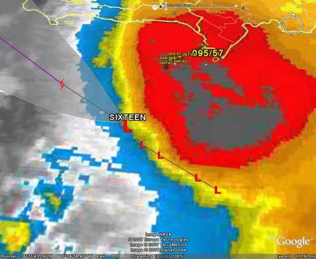
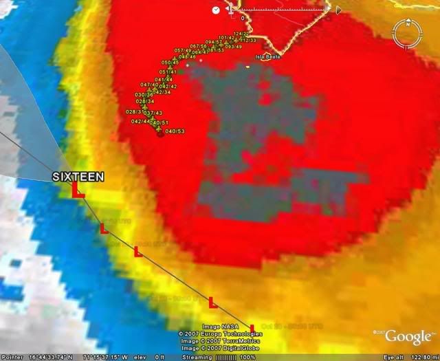
Looks like it's already N of track. That brings it closer to the mountains. Spin in the CDO looks like a hurricane.
0 likes
-
jlauderdal
- S2K Supporter
- Posts: 7240
- Joined: Wed May 19, 2004 5:46 am
- Location: NE Fort Lauderdale
- Contact:
Re: Tropical Depression SIXTEEN : Discussions & Images
caneman wrote:destruction92 wrote:cmc has andros island struck....not miami.....even with that track, SE florida is spared.
when the gfdl starts pointing at florida, then start paying attention.
Umm, you must be mixing up the GFDL with years past. It hasn't done well this year and is thus far been ignored by the NHC>
oh really, you really think nhc ignores the gfdl?
0 likes
Re: Tropical Depression SIXTEEN Recon discussion
heights look to support near 995 system as they approach the center...
0 likes

Re: Tropical Depression SIXTEEN Recon discussion
cycloneye wrote:They may be having some transmission problems.
It looks that way by the lack of obs and dropsondes.
Yes, they been in their for some time now. May have already done a VDM and it looks like their finding a fairly strong TS, to nobody's suprise.
Actually looking at the flight path, they probably haven't done a fix yet.
Last edited by Thunder44 on Sun Oct 28, 2007 12:37 pm, edited 1 time in total.
0 likes
-
caneman
Re: Tropical Depression SIXTEEN : Discussions & Images
jlauderdal wrote:caneman wrote:destruction92 wrote:cmc has andros island struck....not miami.....even with that track, SE florida is spared.
when the gfdl starts pointing at florida, then start paying attention.
Umm, you must be mixing up the GFDL with years past. It hasn't done well this year and is thus far been ignored by the NHC>
oh really, you really think nhc ignores the gfdl?
Read for yourself from 11:00. Its been clear the NHC hasn't trusted as much in the model this year as much as they have in the past. I know because I bandwagoned with GFDL alot this year only to have been burned. And perhaps discounting or not paying as much attention to is better wording than ignoring.
SOME OF THE TRACK MODELS...IN
PARTICULAR THE GFDL AND HWRF...RESPOND TO THIS PATTERN CHANGE BY
FORECASTING A RELATIVELY QUICK RECURVATURE OUT OF THE CARIBBEAN VIA
EASTERN CUBA. MOST OF THE GLOBAL MODELS...HOWEVER...FORECAST A
SLOWER MOTION GENERALLY TOWARD THE WEST-NORTHWEST AND KEEP THE
CYCLONE SOUTH OF CUBA BETWEEN 3 AND 5 DAYS. THE NEW OFFICIAL TRACK
FORECAST FOLLOWS THE SAME PATH AS IN THE PREVIOUS ADVISORY...BUT AT
A SLIGHTLY SLOWER PACE IN DEFERENCE TO THE GLOBAL MODELS.
Last edited by caneman on Sun Oct 28, 2007 12:40 pm, edited 1 time in total.
0 likes

Who is online
Users browsing this forum: No registered users and 41 guests