CAT 5 Hurricane Dean - Archived threads
Moderator: S2k Moderators
-
hurricanefloyd5

- Category 5

- Posts: 1659
- Age: 45
- Joined: Sun May 02, 2004 10:53 am
- Location: Spartanburg
- Contact:
Re: Hurricane DEAN: Global Models=12z run of models are posted
I have to agree it might be taking the track to the edge of the cone off error!!!!!! but i think it wont make landfall on the YP just stay over waters!!!!!
0 likes
-
weatherguru18
Re: Major Hurricane DEAN: (2 PM page 224) Discussions, Analysis
Sanibel wrote:Post by "Southerngale" - 2nd down - Page 150 - "Models" thread
http://wxcaster.com/GFS_ENSEMBLE_GULF-MEXICO_DEAN.png
Thanks...but how reliable are those models? Do they don't even have names, just numbers.
0 likes
Re: Major Hurricane DEAN: (2 PM page 224) Discussions, Analysis
Follow the trend. The reason they do the spaghetti charts is because they tend to average correctly. The rest has been said numerous time about changes.
0 likes
-
Extremeweatherguy

- Category 5
- Posts: 11095
- Joined: Mon Oct 10, 2005 8:13 pm
- Location: Florida
FWIW, JB currently thinks Dean will move in and make landfall in south Texas. He thinks that there are just too many things that could happen over the next few days that it would need pretty much the perfect setup to move into Mexico (which he doesn't think will happen). He does have a worry that it could go further north than that, but ATM he does not think it will. Considering he got Erin pretty much dead on, I will definitely be listening to him closely with Dean too.
0 likes
-
windstorm99

- S2K Supporter

- Posts: 1578
- Age: 48
- Joined: Sat May 26, 2007 8:10 am
- Location: Miami, Florida
- Contact:
-
Wthrman13

- Professional-Met

- Posts: 502
- Joined: Sun Jul 06, 2003 12:44 pm
- Location: West Lafayette, IN
- Contact:
Re: Major Hurricane DEAN: (2 PM page 224) Discussions, Analysis
weatherguru18 wrote:Sanibel wrote:Post by "Southerngale" - 2nd down - Page 150 - "Models" thread
http://wxcaster.com/GFS_ENSEMBLE_GULF-MEXICO_DEAN.png
Thanks...but how reliable are those models? Do they don't even have names, just numbers.
Those are tracks of the hurricane from several different runs of the GFS model (collectively called an ensemble), each one with a slightly "tweaked" initial condition. They do this to try to get an idea of the sensitivity of the forecast (not just for the hurricane track, but for all the rest of the weather in the model forecast) to the initial conditions. Since observations have errors, by running several versions of the model whose initial conditions differ within the range of observational error, we can get an idea of how predictable a certain weather pattern is. In the case of Dean, most of the ensemble members have been consistently north of the operational GFS. Why, I'm not sure, but it suggests that the GFS may be too far south in its prediction, or at the very least, it lends greater confidence to a more northern landfall scenario. However, even the GFS ensemble envelope has been slowly shifting south.
0 likes
weatherguru i have been guessing at that same location for landfall for a while.
i also think it gives sw haiti a scare and if it gets close enough to sw haiti that may weaken it a bit for jamaica at least that's what i'm hoping for jam. but i guess that would be at the expense of haiti (so no option is really wonderful) unless ULL is able to somehow shear this thing although i don't think so
i also think it gives sw haiti a scare and if it gets close enough to sw haiti that may weaken it a bit for jamaica at least that's what i'm hoping for jam. but i guess that would be at the expense of haiti (so no option is really wonderful) unless ULL is able to somehow shear this thing although i don't think so
0 likes
-
vacanechaser

- Category 5
- Posts: 1461
- Joined: Wed Dec 03, 2003 9:34 pm
- Location: Portsmouth, Va
- Contact:
Re: Major Hurricane DEAN: (2 PM page 224) Discussions, Analysis
Wthrman13 wrote:weatherguru18 wrote:Sanibel wrote:Post by "Southerngale" - 2nd down - Page 150 - "Models" thread
http://wxcaster.com/GFS_ENSEMBLE_GULF-MEXICO_DEAN.png
Thanks...but how reliable are those models? Do they don't even have names, just numbers.
Those are tracks of the hurricane from several different runs of the GFS model (collectively called an ensemble), each one with a slightly "tweaked" initial condition. They do this to try to get an idea of the sensitivity of the forecast (not just for the hurricane track, but for all the rest of the weather in the model forecast) to the initial conditions. Since observations have errors, by running several versions of the model whose initial conditions differ within the range of observational error, we can get an idea of how predictable a certain weather pattern is. In the case of Dean, most of the ensemble members have been consistently north of the operational GFS. Why, I'm not sure, but it suggests that the GFS may be too far south in its prediction, or at the very least, it lends greater confidence to a more northern landfall scenario. However, even the GFS ensemble envelope has been slowly shifting south.
and generally speaking, the ensemble runs usually do better than the operational run.. so, the u.s. (texas) is not out of the woods just yet..
Jesse V. Bass III
http://www.vastormphoto.com
Hurricane Intercept Research Team
0 likes
-
ConvergenceZone
.gif)
- Category 5
- Posts: 5241
- Joined: Fri Jul 29, 2005 1:40 am
- Location: Northern California
Re: Major Hurricane DEAN: (2 PM page 224) Discussions, Analysis
yep, if anything the models are moving further south...I wouldn't be shocked to see them completely south of Brownsville by tonight....They are slowly all coming into agreement on where Dean is going. I think we will see a further consolidation with them tomorrow, really narrowing it down.
0 likes
-
Cape Verde

- Category 2

- Posts: 564
- Age: 70
- Joined: Tue Aug 31, 2004 5:53 pm
- Location: Houston area


-
hurrican19
- Tropical Storm

- Posts: 153
- Joined: Sun Jun 13, 2004 1:36 pm
- Location: Northwest Austin, TX
Re: Hurricane DEAN: Global Models
southerngale wrote:tolakram wrote:and all those tracks had the Storms south of Jamacia....what would happen to the tracks if the Storms were North of Jamacia as we will probably see in the case of Dean?
I don't understand why people are comparing Dean to other tracks? The track is dependent on the weather around the storm, not a previous track.
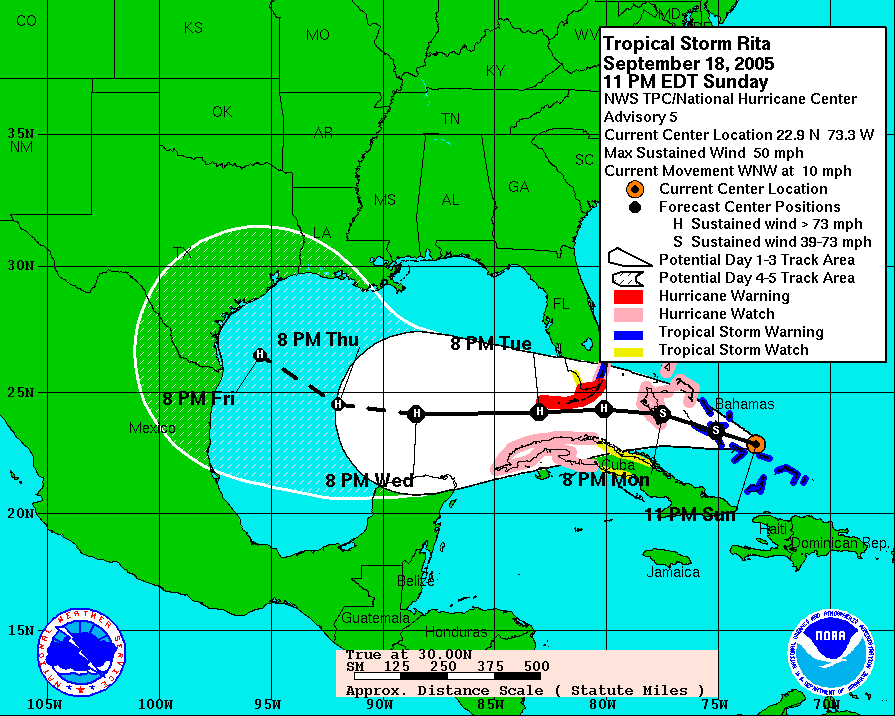
True... totally different scenario. I think the comparison to the Rita forecast track (at least for me) was that 5 days out, it seemed like SE TX would NOT get hit. The models, as well as the official 5 day track, pointed to Northern Mexico / Deep South Texas. With Rita still on everyone's mind (at least where I live), there's just an uneasy feeling of something similar occurring. That's all. I think it's normal to be a little nervous after going through the hell that was Rita. Exactly 5 days later from this advisory (10 pm cdt Friday), we were sitting in the pitch dark, with Rita's winds howling outside as she approached the coast.
I guess they didn't archive the 5-day graphic, but here's the 3-day, 5 days out, plus a few hours.
Found the 5day cone.
0 likes
-
vacanechaser
- Category 5
- Posts: 1461
- Joined: Wed Dec 03, 2003 9:34 pm
- Location: Portsmouth, Va
- Contact:
Re: Hurricane DEAN: Global Models=12z run of models are posted
looks way to far south to me.. of course i have been known to be wrong before!!!
Jesse V. Bass III
http://www.vastormphoto.com
Hurricane Intercept Research Team
0 likes
-
Extremeweatherguy
- Category 5
- Posts: 11095
- Joined: Mon Oct 10, 2005 8:13 pm
- Location: Florida
Re: Hurricane DEAN: Global Models=12z run of models are posted
The NOGAPS just seems so weird to me. It is pretty much in line with the other models for 24-48 hours and then it all of the sudden it makes the storm dive SW. It would sure be weird to see something like that happen.
0 likes
-
Extremeweatherguy
- Category 5
- Posts: 11095
- Joined: Mon Oct 10, 2005 8:13 pm
- Location: Florida
I think I should post this here too for anyone that was wondering about JBs latest thoughts..
FWIW, JB currently thinks Dean will move in and make landfall in south Texas. He thinks that there are just too many things that could happen over the next few days that it would need pretty much the perfect setup to move into Mexico (which he doesn't think will happen). He does have a worry that it could go further north than south TX, but ATM he does not think it will. Considering he got Erin pretty much dead on, I will definitely be listening to him closely with Dean too.
FWIW, JB currently thinks Dean will move in and make landfall in south Texas. He thinks that there are just too many things that could happen over the next few days that it would need pretty much the perfect setup to move into Mexico (which he doesn't think will happen). He does have a worry that it could go further north than south TX, but ATM he does not think it will. Considering he got Erin pretty much dead on, I will definitely be listening to him closely with Dean too.
Last edited by Extremeweatherguy on Sat Aug 18, 2007 1:36 pm, edited 1 time in total.
0 likes
-
HouTXmetro

- Category 5
- Posts: 3949
- Joined: Sun Jun 13, 2004 6:00 pm
- Location: District of Columbia, USA
Re: Major Hurricane DEAN: (2 PM page 224) Discussions, Analysis
ConvergenceZone wrote:yep, if anything the models are moving further south...I wouldn't be shocked to see them completely south of Brownsville by tonight....They are slowly all coming into agreement on where Dean is going. I think we will see a further consolidation with them tomorrow, really narrowing it down.
I don't think you can be confident on at track until about 48-60 hours out.
0 likes
-
vacanechaser
- Category 5
- Posts: 1461
- Joined: Wed Dec 03, 2003 9:34 pm
- Location: Portsmouth, Va
- Contact:
Re: Hurricane DEAN: Global Models=12z run of models are posted
Extremeweatherguy wrote:The NOGAPS just seems so weird to me. It is pretty much in line with the other models for 24-48 hours and then it all of the sudden it makes the storm dive SW. It would sure be weird to see something like that happen.
well, i will say this, the nogaps didnt even have dean developing for days while all the other models did.. so the nogaps has been one i have not looked at much.. seemed to be in la la land from the begining
Jesse V. Bass III
http://www.vastormphoto.com
Hurricane Intercept Research Team
0 likes
-
WindRunner

- Category 5
- Posts: 5803
- Age: 35
- Joined: Fri Jul 29, 2005 8:07 pm
- Location: Warrenton, VA, but Albany, NY for school
- Contact:
-
Innotech

- Category 5
- Posts: 1031
- Joined: Mon Aug 30, 2004 5:32 pm
- Location: Lafayette, Louisiana
- Contact:
Re: Major Hurricane DEAN: (2 PM page 224) Discussions, Analysis
Dean REALLY looks like a Cat 5 now. extremely dense and thick CDO, perfect eye, almost annular structure....Jesus.
0 likes
Who is online
Users browsing this forum: No registered users and 15 guests