CAT 5 Hurricane Dean - Archived threads

Moderator: S2k Moderators

Message
Author
User avatar
Dionne
S2K Supporter
S2K Supporter
Posts: 1616
Age: 72
Joined: Mon Jan 02, 2006 8:51 am
Location: SW Mississippi....Alaska transplant via a Southern Belle.

Re: Pictures from rightside eyewall?

#11561 Postby Dionne » Wed Aug 22, 2007 10:50 am

Harry Cane wrote:For me the most astonishing picture is of the house on the beach (with the two soldiers). I mean this is a concrete structure that has been lifted and pushed to the side. Just look at the loo's position.... :shocked!:


Even reinforced concrete cannot withstand storm surge. We saw the same thing on the gulf coast with Katrina. Very interesting picture. Similar structural designs like this are used in the West Indies.....stacked block, poured solid with rebar.
0 likes   

tolakram
Admin
Admin
Posts: 19165
Age: 60
Joined: Sun Aug 27, 2006 8:23 pm
Location: Florence, KY (name is Mark)

Re: Cat 1 Hurricane DEAN: 7 AM p326, discussions, analyses, sat

#11562 Postby tolakram » Wed Aug 22, 2007 11:00 am

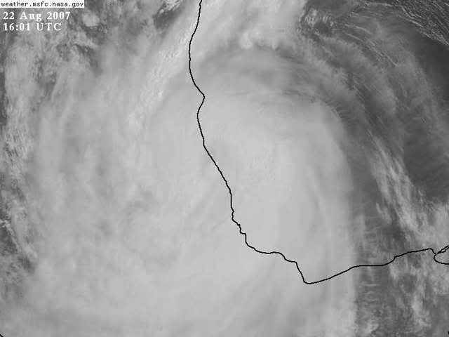
Looks like landfall.

Good riddance Dean.

Image
0 likes   

User avatar
karenfromheaven
Tropical Storm
Tropical Storm
Posts: 166
Age: 69
Joined: Thu Sep 09, 2004 4:45 pm
Location: Lehigh Acres FL

Re: Re:

#11563 Postby karenfromheaven » Wed Aug 22, 2007 11:18 am

isawitonline wrote:
Derek Ortt wrote:is that 10 dead in jamaica or 10 total dead in all affected states


They were reporting 10 dead in Jamaica but having read 2 in most reports I would find that 10 to be overall (at least for now).


The Jamaica Star is reporting 3 dead:
http://www.jamaica-star.com/thestar/200 ... news5.html
0 likes   

User avatar
HURAKAN
Professional-Met
Professional-Met
Posts: 46086
Age: 37
Joined: Thu May 20, 2004 4:34 pm
Location: Key West, FL
Contact:

#11564 Postby HURAKAN » Wed Aug 22, 2007 11:22 am

HURRICANE DEAN DISCUSSION NUMBER 38
NWS TPC/NATIONAL HURRICANE CENTER MIAMI FL AL042007
1100 AM EDT WED AUG 22 2007

AN AIR FORCE RESERVE UNIT RECONNAISSANCE AIRCRAFT INVESTIGATING DEAN
IS FINDING FLIGHT LEVEL WINDS OF CLOSE TO 100 KT...AND RECENT
OBSERVATIONS ARE SHOWING A CONTRACTION OF THE INNER CORE WIND
FIELD. A DROPSONDE ABOUT 20 NMI NORTH OF THE CENTER RECENTLY
REPORTED A WL150...I.E. LOW-LEVEL...MEAN WIND OF 100 KT...
CORRESPONDING TO 85 KT AT THE SURFACE. ON THIS BASIS...THE
ADVISORY INTENSITY IS INCREASED TO 85 KT...MAKING DEAN A CATEGORY
TWO HURRICANE. FORTUNATELY...THESE CHANGES IN THE CORE STRUCTURE
ARE OCCURRING TOO CLOSE TO LANDFALL TO ALLOW FOR MUCH FURTHER
INTENSIFICATION.

THE INITIAL MOTION IS ABOUT THE SAME...285/16. THERE HAS BEEN NO
CHANGE IN THE TRACK FORECAST THINKING...AND DEAN IS EXPECTED TO
MAKE LANDFALL WITHIN THE NEXT FEW HOURS NEAR TUXPAN.


FORECAST POSITIONS AND MAX WINDS

INITIAL 22/1500Z 20.6N 96.3W 85 KT
12HR VT 23/0000Z 21.2N 98.6W 65 KT...INLAND
24HR VT 23/1200Z 21.3N 101.6W 25 KT...INLAND
36HR VT 24/0000Z...DISSIPATED

$$
FORECASTER FRANKLIN/MAINELLI

_______________________________________________

Short discussion. I guess since it's (or was) close to landfall and it was discussion #38, there's not much to say that hasn't been said already!!!
0 likes   

User avatar
karenfromheaven
Tropical Storm
Tropical Storm
Posts: 166
Age: 69
Joined: Thu Sep 09, 2004 4:45 pm
Location: Lehigh Acres FL

Re: HURRICANE DEAN - Threat Area - Jamaica, Caymans, Hispanola

#11565 Postby karenfromheaven » Wed Aug 22, 2007 11:22 am

mf_dolphin wrote:Hopefully someone will run across good news and post it here. Keeping a prayer going until then....


THEY MADE IT THROUGH!!

See story in the Jamaica Gleaner:

http://www.jamaica-gleaner.com/gleaner/ ... lead9.html
0 likes   

User avatar
HURAKAN
Professional-Met
Professional-Met
Posts: 46086
Age: 37
Joined: Thu May 20, 2004 4:34 pm
Location: Key West, FL
Contact:

#11566 Postby HURAKAN » Wed Aug 22, 2007 11:24 am

Image

The 9th strongest of all time says bye.
0 likes   

HurricaneHunter914
Category 5
Category 5
Posts: 4439
Age: 30
Joined: Fri Mar 10, 2006 7:36 pm
Location: College Station, TX

#11567 Postby HurricaneHunter914 » Wed Aug 22, 2007 11:25 am

Wow, 100 mph. Seems like Dean is trying to make the most of it's time over water. Hopefully everyone on the coast of Mexico is prepared.
0 likes   

Cozumel
Tropical Low
Tropical Low
Posts: 11
Joined: Sat Aug 18, 2007 5:50 pm

Re: DEAN -Threat Area -Yucatan Peninsula-Belize-Mainland Mexico

#11568 Postby Cozumel » Wed Aug 22, 2007 11:34 am

As many of you have already posted, life in Cozumel and Cancun is back to normal. Many residents have been assisting in relief efforts for the Mayan zone. And yes, from Puerto Aventuras to the southern parts of the state things are quite bad. In Chetumal the water flooded at least five blocks from the bay area inland. Cozumel lost power during the first hours of Tuesday and there's a lot of sand on the roads on other side of the Island, some roads did not do so well; there wasn't too much rain as the winds were quite strong. Many residents in Cozumel will leave their homes "boarded-up" and "just in case".

Como muchos de ustedes ya han mencionado, la vida en Cozumel y Cancun regreso a la normalidad. Muchos residentes han colaborado con los esfuerzos de ayuda hacia la zona maya. Y si, a partir de Puerto Aventuras hacia el sur del estado, las cosas estan un poco mal. En Chetumal el agua inundo cinco cuadras desde la bahia hacia la ciudad. Cozumel perdio la energia electrica durante las primeras horas del martes y hay mucha area sobre la carretera del otro lado de la Isla, algunos pedazos de la carretera no les fue muy bien; no hubo mucha lluvia gracias a los fuertes vientos. Muchos residentes en Cozumel dejaran las tablas colocadas en sus casas "por si algo sucede"
0 likes   

User avatar
x-y-no
Category 5
Category 5
Posts: 8359
Age: 63
Joined: Wed Aug 11, 2004 12:14 pm
Location: Fort Lauderdale, FL

Re: HURRICANE DEAN - Threat Area - Jamaica, Caymans, Hispanola

#11569 Postby x-y-no » Wed Aug 22, 2007 11:53 am

karenfromheaven wrote:
mf_dolphin wrote:Hopefully someone will run across good news and post it here. Keeping a prayer going until then....


THEY MADE IT THROUGH!!

See story in the Jamaica Gleaner:

http://www.jamaica-gleaner.com/gleaner/ ... lead9.html


Wow ... great news!
0 likes   

User avatar
Ptarmigan
Category 5
Category 5
Posts: 5272
Joined: Wed Aug 16, 2006 9:06 pm

Re: Cat 2 Hurricane DEAN: 10 AM p327, discussions, analyses, sat

#11570 Postby Ptarmigan » Wed Aug 22, 2007 11:55 am

Adios Dean. :grrr:
0 likes   

User avatar
msbee
S2K Supporter
S2K Supporter
Posts: 3010
Joined: Wed Jun 11, 2003 10:11 am
Location: St. Maarten

Re: HURRICANE DEAN - Threat Area - Jamaica, Caymans, Hispanola

#11571 Postby msbee » Wed Aug 22, 2007 11:56 am

x-y-no wrote:
karenfromheaven wrote:
mf_dolphin wrote:Hopefully someone will run across good news and post it here. Keeping a prayer going until then....


THEY MADE IT THROUGH!!

See story in the Jamaica Gleaner:

http://www.jamaica-gleaner.com/gleaner/ ... lead9.html


Wow ... great news!


fabulous!
0 likes   

Ed Mahmoud

Re: Cat 2 Hurricane DEAN: 10 AM p327, discussions, analyses, sat

#11572 Postby Ed Mahmoud » Wed Aug 22, 2007 12:13 pm

Ptarmigan wrote:Adios Dean. :grrr:


The GFS shows the 700 mb vorticity making ot over the mountains, regaining some strength, and passing near Cabo San Lucas.
0 likes   

Windsurfer_NYC
Tropical Storm
Tropical Storm
Posts: 233
Joined: Wed Jun 07, 2006 3:27 pm
Location: New York, NY

#11573 Postby Windsurfer_NYC » Wed Aug 22, 2007 12:17 pm

HURRICANE DEAN TROPICAL CYCLONE UPDATE
NWS TPC/NATIONAL HURRICANE CENTER MIAMI FL AL042007
1150 AM CDT WED AUG 22 2007

THE CENTER OF HURRICANE DEAN MADE LANDFALL IN MEXICO NEAR THE TOWN
OF TECOLUTLA...JUST EAST OF GUTIERREZ ZAMORA AND ABOUT 40 MILES
SOUTH-SOUTHEAST OF TUXPAN AT ABOUT 1130 AM CDT...1630 UTC. THE
ESTIMATED INTENSITY OF DEAN AT LANDFALL WAS 100 MPH...160
KPH....CATEGORY TWO ON THE SAFFIR-SIMPSON HURRICANE SCALE.
0 likes   

User avatar
HURAKAN
Professional-Met
Professional-Met
Posts: 46086
Age: 37
Joined: Thu May 20, 2004 4:34 pm
Location: Key West, FL
Contact:

#11574 Postby HURAKAN » Wed Aug 22, 2007 12:55 pm

Image

Based on the recount by the NHC, this picture was taken 2 minutes after landfall.
0 likes   

User avatar
HURAKAN
Professional-Met
Professional-Met
Posts: 46086
Age: 37
Joined: Thu May 20, 2004 4:34 pm
Location: Key West, FL
Contact:

#11575 Postby HURAKAN » Wed Aug 22, 2007 12:56 pm

...Dean inland over Mexico and beginning to weaken...


a Hurricane Warning remains in effect along the Gulf Coast of Mexico
from Coatzacoalcos northward to La Cruz.


A Tropical Storm Warning remains in effect along the Gulf Coast of
Mexico from north of La Cruz to Bahia Algodones.


For storm information specific to your area...including possible
inland watches and warnings...please monitor products issued
by your local weather office.


At 100 PM CDT...1800z...the center of Hurricane Dean was located
inland near latitude 20.5 north...longitude 97.3 west or very near
poza rica Mexico.


Dean is moving toward the west near 19 mph...31 km/hr...and this
motion is expected to continue through tonight.


Maximum sustained winds have decreased to near 85 mph...140 km/hr...
with higher gusts. Dean is now a category one hurricane on the
Saffir-Simpson scale. Continued weakening is expected until Dean
dissipates over the mountains of central Mexico tonight.


Hurricane force winds extend outward up to 70 miles...110 km...from
the center...and tropical storm force winds extend outward up to 275
miles...445 km...mainly to the northeast of the center.


The estimated minimum central pressure is 982 mb...29.00 inches.


Storm surge flooding of 6 to 8 feet above normal tide levels is
possible...along with large and dangerous battering waves...near and
to the north of where the center made landfall.


Dean is expected to produce storm total rainfall of 5 to 10 inches
over parts of southern and central Mexico...with maximum amounts of
up to 20 inches. These rains could cause life-threatening flash
floods and mudslides.

Repeating the 100 PM CDT position...20.5 N...97.3 W. Movement
toward...west near 19 mph. Maximum sustained winds...85 mph.
Minimum central pressure...982 mb.


The next advisory will be issued by the National Hurricane Center at
400 PM CDT.


$$
Forecaster Franklin/Mainelli
0 likes   

Lost in Belize
Tropical Wave
Tropical Wave
Posts: 8
Joined: Sun Aug 19, 2007 12:57 pm

Re: DEAN -Threat Area -Yucatan Peninsula-Belize-Mainland Mexico

#11576 Postby Lost in Belize » Wed Aug 22, 2007 12:57 pm

Hi All,
Finally got back to a computer. I spent the storm in the western part of Belize in the Cayo Districts. This is high mountainous terrain, and we had little or no effect other than some gusts up to 30-40mph and a bit of rain. Belize City sustained no damage whatsoever, even though it was pretty much evacuated. I took a boat trip to Ambergris Caye later yesterday afternoon. We were the only boat on the water, as the return to the town had not yet started. The island was mostly out of power, but power was restored by 6:30 pm to most areas. There is little sign of major damage, except to docks, most of which are left crooked with missing planks and shaky pilings. There is some beach erosion evident along the main seawall with huge gaping holes where sand used to be. Since about 9000 of the 12000 residents were evacuated, the island seemed deserted, although a few grocery stores were open. The good news is the the tourism infrastructure on teh island remains intact, and none of the hotels seem to have sustained any significant damage.

Reports from Northern Belize are not as encouraging. The Papaya Industry, which is owned by Brooks Tropical, and represents the largest importer of papayas into the US and Canada and a very large employer in Northern Belize lost a large percentage of their crops. Company officials are assessing the damage, and the silver lining is that Brooks, headquartered in Homestead, FL, is no stranger to hurricane recovery, having lost and recovered a major production of Avocados after Hurricane Andrew in 1992.

Corozal Town lost a few houses, several roofs, but thankfully no loss of life. Power is still down in the area, but damage is a lot less than was expected in light of a Cat 5 storm.

Belize
0 likes   

User avatar
HURAKAN
Professional-Met
Professional-Met
Posts: 46086
Age: 37
Joined: Thu May 20, 2004 4:34 pm
Location: Key West, FL
Contact:

#11577 Postby HURAKAN » Wed Aug 22, 2007 1:01 pm

Image

Dean: "Damn it, land again. I should've bough a GPS or at least a compass."
0 likes   

User avatar
msbee
S2K Supporter
S2K Supporter
Posts: 3010
Joined: Wed Jun 11, 2003 10:11 am
Location: St. Maarten

Re: DEAN -Threat Area -Yucatan Peninsula-Belize-Mainland Mexico

#11578 Postby msbee » Wed Aug 22, 2007 1:05 pm

I am os happy to read your post and see that Belize came through relatively OK>
Belize is one of my favorite places in the whole world.
0 likes   

User avatar
cycloneye
Admin
Admin
Posts: 139081
Age: 67
Joined: Thu Oct 10, 2002 10:54 am
Location: San Juan, Puerto Rico

Re: DEAN -Threat Area -Yucatan Peninsula-Belize-Mainland Mexico

#11579 Postby cycloneye » Wed Aug 22, 2007 1:16 pm

I am also happy to see that Belize did not suffer too much.

Belice salio relativamente bien de esto.Claro siempre hubo daños pero no perdida de vidas.
0 likes   

User avatar
cycloneye
Admin
Admin
Posts: 139081
Age: 67
Joined: Thu Oct 10, 2002 10:54 am
Location: San Juan, Puerto Rico

Re: Hurricane DEAN Advisories & Official Forecast Maps

#11580 Postby cycloneye » Wed Aug 22, 2007 1:19 pm

089
WTNT34 KNHC 221753
TCPAT4
BULLETIN
HURRICANE DEAN INTERMEDIATE ADVISORY NUMBER 38A
NWS TPC/NATIONAL HURRICANE CENTER MIAMI FL AL042007
100 PM CDT WED AUG 22 2007

...DEAN INLAND OVER MEXICO AND BEGINNING TO WEAKEN...

A HURRICANE WARNING REMAINS IN EFFECT ALONG THE GULF COAST OF MEXICO
FROM COATZACOALCOS NORTHWARD TO LA CRUZ.

A TROPICAL STORM WARNING REMAINS IN EFFECT ALONG THE GULF COAST OF
MEXICO FROM NORTH OF LA CRUZ TO BAHIA ALGODONES.

FOR STORM INFORMATION SPECIFIC TO YOUR AREA...INCLUDING POSSIBLE
INLAND WATCHES AND WARNINGS...PLEASE MONITOR PRODUCTS ISSUED
BY YOUR LOCAL WEATHER OFFICE.

AT 100 PM CDT...1800Z...THE CENTER OF HURRICANE DEAN WAS LOCATED
INLAND NEAR LATITUDE 20.5 NORTH...LONGITUDE 97.3 WEST OR VERY NEAR
POZA RICA MEXICO.

DEAN IS MOVING TOWARD THE WEST NEAR 19 MPH...31 KM/HR...AND THIS
MOTION IS EXPECTED TO CONTINUE THROUGH TONIGHT.

MAXIMUM SUSTAINED WINDS HAVE DECREASED TO NEAR 85 MPH...140 KM/HR...
WITH HIGHER GUSTS. DEAN IS NOW A CATEGORY ONE HURRICANE ON THE
SAFFIR-SIMPSON SCALE. CONTINUED WEAKENING IS EXPECTED UNTIL DEAN
DISSIPATES OVER THE MOUNTAINS OF CENTRAL MEXICO TONIGHT.

HURRICANE FORCE WINDS EXTEND OUTWARD UP TO 70 MILES...110 KM...FROM
THE CENTER...AND TROPICAL STORM FORCE WINDS EXTEND OUTWARD UP TO 275
MILES...445 KM...MAINLY TO THE NORTHEAST OF THE CENTER.

THE ESTIMATED MINIMUM CENTRAL PRESSURE IS 982 MB...29.00 INCHES.

STORM SURGE FLOODING OF 6 TO 8 FEET ABOVE NORMAL TIDE LEVELS IS
POSSIBLE...ALONG WITH LARGE AND DANGEROUS BATTERING WAVES...NEAR AND
TO THE NORTH OF WHERE THE CENTER MADE LANDFALL.

DEAN IS EXPECTED TO PRODUCE STORM TOTAL RAINFALL OF 5 TO 10 INCHES
OVER PARTS OF SOUTHERN AND CENTRAL MEXICO...WITH MAXIMUM AMOUNTS OF
UP TO 20 INCHES. THESE RAINS COULD CAUSE LIFE-THREATENING FLASH
FLOODS AND MUDSLIDES.

REPEATING THE 100 PM CDT POSITION...20.5 N...97.3 W. MOVEMENT
TOWARD...WEST NEAR 19 MPH. MAXIMUM SUSTAINED WINDS...85 MPH.
MINIMUM CENTRAL PRESSURE...982 MB.

THE NEXT ADVISORY WILL BE ISSUED BY THE NATIONAL HURRICANE CENTER AT
400 PM CDT.

$$
FORECASTER FRANKLIN/MAINELLI
0 likes   


Return to “2007”

Who is online

Users browsing this forum: No registered users and 131 guests